List of listed buildings in Wigtown, Dumfries and Galloway
This is a list of listed buildings in the civil parish of Wigtown, in Dumfries and Galloway, Scotland.
List
| Name | Location | Date Listed | Grid Ref. [note 1] | Geo-coordinates | Notes | LB Number [note 2] | Image |
|---|---|---|---|---|---|---|---|
| Harbour Road Dunmore With Gates Gatepiers And Boundary Walls | 54°52′00″N 4°26′22″W | Category C(S) | 42390 |  | |||
| 10 And 12 High Street | 54°52′01″N 4°26′42″W | Category C(S) | 42396 | | |||
| 3A And 3B North Main Street | 54°52′08″N 4°26′32″W | Category C(S) | 42401 | | |||
| 17 North Main Street | 54°52′06″N 4°26′37″W | Category B | 42409 | | |||
| 27 North Main Street | 54°52′04″N 4°26′40″W | Category C(S) | 42414 | | |||
| 6 South Main Street | 54°52′06″N 4°26′28″W | Category B | 42422 | | |||
| 18 South Main Street | 54°52′04″N 4°26′33″W | Category B | 42427 | | |||
| 24 South Main Street | 54°52′03″N 4°26′36″W | Category B | 42430 | | |||
| Windy Hill Martyrs Monument And Enclosure | 54°52′08″N 4°26′51″W | Category B | 42442 | 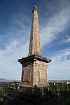 | |||
| 1-4 (Inclusive Nos) Acre Place | 54°51′57″N 4°26′41″W | Category C(S) | 42336 | | |||
| 26 And 28 Agnew Crescent | 54°51′58″N 4°26′39″W | Category C(S) | 42349 | | |||
| 7 Bank Street | 54°52′08″N 4°26′28″W | Category C(S) | 42351 | | |||
| 8 Bank Street | 54°52′08″N 4°26′28″W | Category C(S) | 42358 | | |||
| 24 Bank Street | 54°52′09″N 4°26′25″W | Category C(S) | 42362 | | |||
| 4 And 5 Bladnoch Village | 54°51′29″N 4°27′26″W | Category C(S) | 42366 | | |||
| 27 South Main Street, Post Office | 54°52′03″N 4°26′37″W | Category C(S) | 43768 | | |||
| 19 Bladnoch Village | 54°51′29″N 4°27′32″W | Category C(S) | 42374 | | |||
| 6 And 8 High Street | 54°52′02″N 4°26′41″W | Category C(S) | 42395 | | |||
| 28 High Street | 54°52′01″N 4°26′45″W | Category C(S) | 42397 | | |||
| 32 High Street | 54°52′00″N 4°26′45″W | Category C(S) | 42399 | | |||
| 5 Low Vennel Smithy | 54°52′09″N 4°26′31″W | Category C(S) | 42400 | | |||
| 34 North Main Street The Granite House | 54°52′03″N 4°26′42″W | Category C(S) | 42419 | | |||
| 16 South Main Street Sunningdale | 54°52′04″N 4°26′33″W | Category C(S) | 42426 | | |||
| 22 South Mains Treet | 54°52′04″N 4°26′35″W | Category B | 42428 | | |||
| Woodside With Coach House, Retaining Walls And Railings | 54°51′52″N 4°26′49″W | Category B | 42443 | | |||
| 11 And 13 Agnew Crescent | 54°52′00″N 4°26′41″W | Category C(S) | 42338 | | |||
| 4 Bank Street | 54°52′08″N 4°26′29″W | Category C(S) | 42356 | | |||
| 2 Bladnoch Village | 54°51′29″N 4°27′25″W | Category C(S) | 42365 | | |||
| 11 Bladnoch Village | 54°51′29″N 4°27′28″W | Category C(S) | 42368 | | |||
| 13, 14 And 15 Bladnoch Village | 54°51′29″N 4°27′29″W | Category C(S) | 42370 | | |||
| 26 Bladnoch Village | 54°51′29″N 4°27′36″W | Category C(S) | 42380 | | |||
| Fountainblue Terrace Craigmount Guest House | 54°52′01″N 4°26′50″W | Category C(S) | 42388 | | |||
| 13 North Main Street | 54°52′06″N 4°26′35″W | Category C(S) | 42406 | | |||
| 23 South Main Street Galloway Inn | 54°52′04″N 4°26′35″W | Category B | 42429 | | |||
| 31 And 32 South Main Street | 54°52′02″N 4°26′39″W | Category B | 42435 | | |||
| Bank Street Bank House Garden Wall And Garden Houses | 54°52′08″N 4°26′24″W | Category B | 42363 | | |||
| Bladnoch Bridge | 54°51′28″N 4°27′43″W | Category B | 19151 | | |||
| 24 Bladnoch Village | 54°51′29″N 4°27′34″W | Category C(S) | 42378 | | |||
| 27 Bladnoch Village | 54°51′29″N 4°27′36″W | Category C(S) | 42381 | | |||
| 32 Bladnoch Village | 54°51′30″N 4°27′38″W | Category C(S) | 42383 | | |||
| Harbour Road, Old Prison House With Boundary Walls (Former Jail And Police Station) | 54°51′57″N 4°26′26″W | Category B | 42391 | | |||
| 30 High Street | 54°52′00″N 4°26′45″W | Category C(S) | 42398 | | |||
| 5 And 7 North Main Street | 54°52′08″N 4°26′33″W | Category C(S) | 42403 | | |||
| 29 And 30 North Main Street | 54°52′03″N 4°26′40″W | Category B | 42416 | | |||
| 31 North Main Street | 54°52′03″N 4°26′41″W | Category C(S) | 42417 | | |||
| 29 And 30 South Main Street County Hotel | 54°52′03″N 4°26′39″W | Category C(S) | 42434 | | |||
| The Square Old Market Cross | 54°52′04″N 4°26′37″W | Category B | 42438 | | |||
| The Square Town Hall | 54°52′07″N 4°26′29″W | Category B | 42439 | 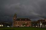 | |||
| 21 Agnew Crescent | 54°51′59″N 4°26′41″W | Category C(S) | 42342 | | |||
| 10 Bank Street | 54°52′09″N 4°26′28″W | Category B | 42359 | | |||
| 20 Bank Street | 54°52′09″N 4°26′26″W | Category C(S) | 42360 | | |||
| 22 Bank Street | 54°52′09″N 4°26′25″W | Category C(S) | 42361 | | |||
| 17 17A And 17B Bladnoch Village | 54°51′29″N 4°27′30″W | Category C(S) | 42372 | | |||
| 9 Harbour Road Former Uf Manse Boundary Wall And Gatepiers | 54°52′02″N 4°26′23″W | Category B | 42392 | | |||
| 18 North Main Street | 54°52′05″N 4°26′37″W | Category C(S) | 42410 | | |||
| 28 North Main Street | 54°52′03″N 4°26′40″W | Category C(S) | 42415 | | |||
| Wigtown Old Parish Church (St Machute`S Church) | 54°52′12″N 4°26′22″W | Category B | 42440 | 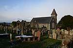 | |||
| 18-20 (Even Nos) Agnew Crescent | 54°51′59″N 4°26′40″W | Category B | 42348 | | |||
| 3 Bank Street | 54°52′07″N 4°26′40″W | Category C(S) | 42350 | | |||
| 11 Bank Street | 54°52′08″N 4°26′27″W | Category C(S) | 42353 | | |||
| 1 Bladnoch Village | 54°51′29″N 4°27′24″W | Category C(S) | 42364 | | |||
| 16 Bladnoch Village | 54°51′29″N 4°27′30″W | Category B | 42371 | | |||
| 18 Bladnoch Village Ashleigh | 54°51′29″N 4°27′31″W | Category B | 42373 | | |||
| 29 Bladnoch Village | 54°51′29″N 4°27′38″W | Category C(S) | 42382 | | |||
| 34 Bladnoch Village And Railings | 54°51′30″N 4°27′40″W | Category C(S) | 42385 | | |||
| 4 High Street | 54°52′02″N 4°26′41″W | Category C(S) | 42394 | | |||
| 11 North Main Street | 54°52′07″N 4°26′34″W | Category B | 42404 | | |||
| 19 North Main Street | 54°52′05″N 4°26′37″W | Category C(S) | 42411 | | |||
| 21 North Main Street, Bank Of Scotland | 54°52′05″N 4°26′38″W | Category C(S) | 42413 | | |||
| 8 South Main Street The Old Custom House And Bank With Railings | 54°52′06″N 4°26′28″W | Category B | 42423 | | |||
| 26 South Main Street | 54°52′03″N 4°26′37″W | Category C(S) | 42432 | | |||
| Wigtown Parish Church (Church Of Scotland) And Churchyard | 54°52′12″N 4°26′21″W | Category B | 42441 | 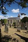 | |||
| 19 Agnew Crescent | 54°51′59″N 4°26′41″W | Category C(S) | 42341 | | |||
| 6 Agnew Crescent | 54°52′01″N 4°26′39″W | Category C(S) | 42343 | | |||
| 10 Agnew Crescent | 54°52′00″N 4°26′39″W | Category C(S) | 42345 | | |||
| 9 Bank Street | 54°52′08″N 4°26′27″W | Category C(S) | 42352 | | |||
| 2 Bank Street | 54°52′08″N 4°26′30″W | Category C(S) | 42355 | | |||
| 7 And 8 Bladnoch | 54°51′29″N 4°27′27″W | Category C(S) | 42367 | | |||
| Newmilns Mill | 54°51′58″N 4°29′28″W | Category C(S) | 19153 | | |||
| Torhousemuir House And Gatepiers | 54°52′50″N 4°30′15″W | Category C(S) | 19154 | | |||
| 20 Bladnoch Village | 54°51′29″N 4°27′32″W | Category C(S) | 42375 | | |||
| Harbour Road Applegarth | 54°52′07″N 4°26′25″W | Category C(S) | 42389 | | |||
| 2 High Street | 54°52′02″N 4°26′41″W | Category C(S) | 42393 | | |||
| 12 North Main Street | 54°52′07″N 4°26′35″W | Category C(S) | 42405 | | |||
| 14 North Main Street | 54°52′06″N 4°26′36″W | Category C(S) | 42407 | | |||
| 15 North Main Street | 54°52′06″N 4°26′36″W | Category C(S) | 42408 | | |||
| 20 North Main Street | 54°52′05″N 4°26′38″W | Category C(S) | 42412 | | |||
| 33 North Main Street The Granite House | 54°52′03″N 4°26′41″W | Category C(S) | 42418 | | |||
| 14 South Main Street | 54°52′05″N 4°26′32″W | Category C(S) | 42424 | | |||
| 25 South Main Street | 54°52′03″N 4°26′37″W | Category C(S) | 42431 | | |||
| The Square, New Market Cross | 54°52′04″N 4°26′37″W | Category B | 42437 | | |||
| 15 Agnew Crescent Rowan House | 54°52′00″N 4°26′41″W | Category C(S) | 42339 | | |||
| 17 Agnew Crescent | 54°51′59″N 4°26′41″W | Category C(S) | 42340 | | |||
| 14 Agnew Crescent | 54°52′00″N 4°26′40″W | Category C(S) | 42346 | | |||
| 16 Agnew Crescent | 54°51′59″N 4°26′40″W | Category C(S) | 42347 | | |||
| 13 And 15 Bank Street | 54°52′08″N 4°26′27″W | Category C(S) | 42354 | | |||
| 6 Bank Street | 54°52′08″N 4°26′29″W | Category B | 42357 | | |||
| Bladnoch Distillery | 54°51′30″N 4°27′45″W | Category B | 19152 | 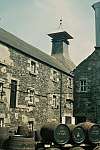 | |||
| 4 Agnew Crescent | 54°52′01″N 4°26′40″W | Category C(S) | 43767 | | |||
| 22 Bladnoch Village | 54°51′29″N 4°27′33″W | Category C(S) | 42376 | | |||
| 23 Bladnoch Village | 54°51′29″N 4°27′34″W | Category C(S) | 42377 | | |||
| 25 Bladnoch Village Riverside | 54°51′29″N 4°27′35″W | Category B | 42379 | | |||
| 33 Bladnoch Village | 54°51′30″N 4°27′39″W | Category B | 42384 | | |||
| Church Lane, The Laigh House (Former Manse) | 54°52′16″N 4°26′26″W | Category C(S) | 42386 | | |||
| Dunure House Boundary Walls Gates And Outbuildings | 54°51′54″N 4°26′40″W | Category B | 42387 | | |||
| 4 North Main Street The Red Lion Inn | 54°52′08″N 4°26′32″W | Category C(S) | 42402 | | |||
| South Main Street Sacred Heart R.C. Church With Gates Gateposts,Railings And Boundary Walls | 54°52′04″N 4°26′31″W | Category C(S) | 42420 | | |||
| 4 South Main Street And Garden Wall | 54°52′07″N 4°26′28″W | Category B | 42421 | | |||
| 15 South Main Street | 54°52′05″N 4°26′32″W | Category C(S) | 42425 | | |||
| 28 South Main Street Craiglachie | 54°52′03″N 4°26′38″W | Category B | 42433 | | |||
| 33 And 34 South Main Street | 54°52′02″N 4°26′40″W | Category C(S) | 42436 | | |||
| 9 Agnew Crescent | 54°52′00″N 4°26′41″W | Category C(S) | 42337 | | |||
| 8 Agnew Crescent | 54°52′01″N 4°26′39″W | Category C(S) | 42344 | | |||
| 12 Bladnoch Village | 54°51′29″N 4°27′28″W | Category C(S) | 42369 | |
Key
The scheme for classifying buildings in Scotland is:
- Category A: "buildings of national or international importance, either architectural or historic; or fine, little-altered examples of some particular period, style or building type."[1]
- Category B: "buildings of regional or more than local importance; or major examples of some particular period, style or building type, which may have been altered."[1]
- Category C: "buildings of local importance; lesser examples of any period, style, or building type, as originally constructed or moderately altered; and simple traditional buildings which group well with other listed buildings."[1]
In March 2016 there were 47,288 listed buildings in Scotland. Of these, 8% were Category A, and 50% were Category B, with the remaining 42% being Category C.[2]
Notes
- Sometimes known as OSGB36, the grid reference (where provided) is based on the British national grid reference system used by the Ordnance Survey.
• "Guide to National Grid". Ordnance Survey. Retrieved 12 December 2007.
• "Get-a-map". Ordnance Survey. Retrieved 17 December 2007. - Historic Environment Scotland assign a unique alphanumeric identifier to each designated site in Scotland, for listed buildings this always begins with "LB", for example "LB12345".
gollark: This is all very, well, 2018.
gollark: Um...
gollark: His shop says 550 per diamond shulker box.
gollark: GMart now has potatoes again after they were all bought up yesterday.
gollark: Visit GMart on Trisomy Street (north of the haskell logo) for low prices on iron (0.8KST), cactus (0.5KST), sugarcane (0.1KST) and potatoes (0.1KST)!
References
- All entries, addresses and coordinates are based on data from Historic Scotland. This data falls under the Open Government Licence
- "What is Listing?". Historic Environment Scotland. Retrieved 29 May 2018.
- Scotland's Historic Environment Audit 2016 (PDF). Historic Environment Scotland and the Built Environment Forum Scotland. pp. 15–16. Retrieved 29 May 2018.
This article is issued from Wikipedia. The text is licensed under Creative Commons - Attribution - Sharealike. Additional terms may apply for the media files.