List of listed buildings in Whithorn, Dumfries and Galloway
This is a list of listed buildings in the civil parish of Whithorn, in Dumfries and Galloway, Scotland.
List
| Name | Location | Date Listed | Grid Ref. [note 1] | Geo-coordinates | Notes | LB Number [note 2] | Image |
|---|---|---|---|---|---|---|---|
| 107 George Street | 54°43′54″N 4°25′01″W | Category B | 43766 |  | |||
| 51 George Street | 54°43′59″N 4°24′57″W | Category C(S) | 42194 | | |||
| 53 George Street And Entrance To Priory | 54°43′59″N 4°24′57″W | Category A | 42195 | 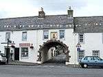 | |||
| 55-57 (Odd Nos) George Street | 54°43′59″N 4°24′57″W | Category A | 42196 | | |||
| 65, 67 And 69 George Street, Including Old Town Hall And Bell Tower | 54°43′58″N 4°24′59″W | Category B | 42197 | 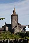 | |||
| 77 George Street, The Clydesdale Bank, Walls And Railings | 54°43′56″N 4°24′59″W | Category C(S) | 42200 | | |||
| 79 George Street | 54°43′56″N 4°24′59″W | Category B | 42201 | | |||
| 83 George Street | 54°43′56″N 4°24′59″W | Category C(S) | 42203 | | |||
| 101 George Street | 54°43′54″N 4°25′01″W | Category C(S) | 42210 | | |||
| 8 George Street | 54°44′03″N 4°24′52″W | Category B | 42220 | | |||
| 58 George Street | 54°43′58″N 4°24′56″W | Category C(S) | 42234 | | |||
| 118 George Street | 54°43′52″N 4°25′01″W | Category C(S) | 42251 | | |||
| 122 George Street | 54°43′51″N 4°25′02″W | Category C(S) | 42253 | | |||
| 25 St John Street | 54°44′09″N 4°24′53″W | Category B | 42259 | | |||
| 70 St John Street | 54°44′04″N 4°24′52″W | Category C(S) | 42263 | | |||
| Isle Of Whithorn, 66-70 (Even Nos) Main Street | 54°41′59″N 4°21′45″W | Category C(S) | 19238 | | |||
| Isle Of Whithorn, 76-78 (Even Nos) Main Street | 54°41′58″N 4°21′44″W | Category C(S) | 19240 | | |||
| Reiffer Park With Retaining Walls | 54°46′42″N 4°25′09″W | Category B | 19247 | | |||
| Isle Of Whithorn, 38 Main Street, Low Isle House | 54°42′03″N 4°21′55″W | Category B | 17070 | | |||
| Isle Of Whithorn, Isle Parish Church (Church Of Scotland) | 54°41′58″N 4°21′46″W | Category B | 16722 | | |||
| 71 And 73 George Street | 54°43′57″N 4°24′58″W | Category B | 42198 | | |||
| 81 George Street | 54°43′56″N 4°24′59″W | Category C(S) | 42202 | | |||
| 85 George Street | 54°43′55″N 4°24′59″W | Category C(S) | 42204 | | |||
| 91-93 (Odd Nos) George Street | 54°43′55″N 4°25′01″W | Category C(S) | 42207 | | |||
| 109 George Street | 54°43′53″N 4°25′02″W | Category B | 42212 | | |||
| 2 George Street (Corner With St John Street) The Cross House | 54°44′04″N 4°24′52″W | Category C(S) | 42217 | | |||
| 12-14 (Even Nos) George Street And Rubble Wall To Rear | 54°44′02″N 4°24′53″W | Category B | 42222 | | |||
| 26 George Street | 54°44′01″N 4°24′54″W | Category B | 42226 | | |||
| 30-32 (Even Nos) George Street | 54°44′00″N 4°24′54″W | Category B | 42228 | | |||
| 60 George Street | 54°43′58″N 4°24′56″W | Category B | 42235 | | |||
| 96 And 98 George Street | 54°43′54″N 4°24′58″W | Category C(S) | 42241 | | |||
| 102 George Street | 54°43′53″N 4°24′59″W | Category B | 42243 | | |||
| 112 George Street | 54°43′52″N 4°25′01″W | Category B | 42248 | | |||
| 114 George Street | 54°43′52″N 4°25′01″W | Category C(S) | 42249 | | |||
| 126 George Street | 54°43′51″N 4°25′02″W | Category B | 42255 | | |||
| 33 High Street | 54°43′46″N 4°25′08″W | Category C(S) | 42258 | | |||
| 53 St John Street, Whithorn Town Hall With Gate, Railings And Quadrant Wall | 54°44′06″N 4°24′54″W | Category C(S) | 42261 | | |||
| Whithorn Priory | 54°44′01″N 4°25′01″W | Category A | 42266 | 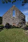 | |||
| Isle Of Whithorn, 24-30 (Even Nos) Main Street | 54°42′03″N 4°21′59″W | Category C(S) | 19233 | | |||
| Isle Of Whithorn, 86 Main Street | 54°41′57″N 4°21′42″W | Category C(S) | 19243 | | |||
| Isle Of Whithorn, 12 Main Street | 54°42′04″N 4°22′03″W | Category C(S) | 16724 | | |||
| Isle Of Whithorn, 14 Main Street | 54°42′04″N 4°22′03″W | Category C(S) | 16725 | | |||
| Castlewigg Steading, Principal Range | 54°45′33″N 4°26′48″W | Category C(S) | 16750 | | |||
| Bruce Street, Museum And Custodian's House And Boundary Walls | 54°44′00″N 4°25′00″W | Category B | 42185 | | |||
| 17 George Street, The Central Cafe | 54°44′02″N 4°24′55″W | Category C(S) | 42191 | | |||
| 89 George Street | 54°43′55″N 4°25′00″W | Category B | 42206 | | |||
| 111-113 (Odd Nos) George Street | 54°43′53″N 4°25′02″W | Category C(S) | 42213 | | |||
| 137 George Street | 54°43′51″N 4°25′04″W | Category B | 42216 | | |||
| 56 George Street | 54°43′58″N 4°24′56″W | Category C(S) | 42233 | | |||
| 108 George Street | 54°43′53″N 4°25′00″W | Category B | 42246 | | |||
| 130 George Street | 54°43′50″N 4°25′02″W | Category C(S) | 42257 | | |||
| Whithorn Manse | 54°44′04″N 4°25′09″W | Category B | 42264 | | |||
| Isle Of Whithorn, 80 Main Street | 54°41′58″N 4°21′43″W | Category C(S) | 19241 | | |||
| Isle Of Whithorn, Isle Castle | 54°42′05″N 4°21′57″W | Category A | 16751 | | |||
| Isle Of Whithorn, Harbour Row, Warehouses Including Isle Smugglers | 54°41′54″N 4°21′46″W | Category B | 16755 | | |||
| 11 George Street | 54°44′02″N 4°24′54″W | Category C(S) | 42189 | | |||
| 28 George Street | 54°44′01″N 4°24′54″W | Category B | 42227 | | |||
| 52-54 (Even Nos) George Street | 54°43′58″N 4°24′55″W | Category C(S) | 42232 | | |||
| 94 George Street | 54°43′54″N 4°24′58″W | Category B | 42240 | | |||
| 120 George Street | 54°43′52″N 4°25′01″W | Category C(S) | 42252 | | |||
| Whithorn Parish Church, (Church Of Scotland) And Graveyard | 54°44′02″N 4°25′03″W | Category B | 42265 | | |||
| Isle Of Whithorn, 5 Tonderghie Road | 54°42′02″N 4°22′02″W | Category C(S) | 19246 | | |||
| Tonderghie House | 54°41′31″N 4°25′02″W | Category A | 19248 | 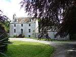 | |||
| Isle Of Whithorn, 16 Main Street | 54°42′04″N 4°22′02″W | Category B | 16726 | | |||
| Broughton Mains Farmhouse | 54°46′34″N 4°24′34″W | Category B | 16740 | | |||
| Isle Of Whithorn, Harbour | 54°41′53″N 4°21′48″W | Category B | 16753 | | |||
| 7-9 (Odd Nos) George Street | 54°44′03″N 4°24′54″W | Category B | 42188 | | |||
| 103-105 (Odd Nos) George Street | 54°43′54″N 4°25′01″W | Category C(S) | 42211 | | |||
| 6 George Street | 54°44′03″N 4°24′52″W | Category B | 42219 | | |||
| 16-18 (Even Nos) George Street | 54°44′01″N 4°24′53″W | Category B | 42223 | | |||
| 34 George Street | 54°44′00″N 4°24′54″W | Category B | 42229 | | |||
| 36 And 38 George Street | 54°44′00″N 4°24′55″W | Category C(S) | 42230 | | |||
| Isle Of Whithorn, 20 Main Street | 54°42′03″N 4°22′02″W | Category B | 19231 | | |||
| Isle Of Whithorn, 62 Main Street | 54°41′59″N 4°21′45″W | Category C(S) | 19236 | | |||
| Isle Of Whithorn, 64 Main Street | 54°41′59″N 4°21′45″W | Category C(S) | 19237 | | |||
| Isle Of Whithorn, 72-74 (Even Nos) Main Street | 54°41′59″N 4°21′44″W | Category C(S) | 19239 | | |||
| Isle Of Whithorn, 82 Main Street | 54°41′58″N 4°21′43″W | Category B | 19242 | | |||
| Isle Of Whithorn, 3 Tonderghie Road | 54°42′02″N 4°22′02″W | Category B | 19245 | | |||
| Isle Of Whithorn, Harbour Row, Harbour House, The Wigtown Bay Sailing Club | 54°41′57″N 4°21′44″W | Category C(S) | 16754 | | |||
| Castlewigg Castle | 54°45′32″N 4°26′42″W | Category B | 16741 | | |||
| 5 George Street | 54°44′03″N 4°24′54″W | Category C(S) | 42187 | | |||
| 19 George Street, The Royal Bank Of Scotland | 54°44′02″N 4°24′55″W | Category C(S) | 42192 | | |||
| 99 George Street | 54°43′54″N 4°25′00″W | Category C(S) | 42209 | | |||
| 125-127 (Odd Nos) George Street | 54°43′52″N 4°25′03″W | Category B | 42214 | | |||
| 129 George Street | 54°43′51″N 4°25′04″W | Category B | 42215 | | |||
| 70 And 72 George Street | 54°43′56″N 4°24′56″W | Category B | 42238 | | |||
| 124 George Street | 54°43′51″N 4°25′02″W | Category C(S) | 42254 | | |||
| Isle Of Whithorn, 58 Main Street | 54°42′00″N 4°21′46″W | Category C(S) | 19234 | | |||
| Tonderghie Steadings | 54°41′22″N 4°25′07″W | Category A | 19249 | | |||
| Isle Of Whithorn, St Ninians Kirk | 54°41′53″N 4°21′39″W | Category B | 16723 | 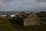 | |||
| Isle Of Whithorn, 13 Main Street, Captain's Garden, Formerly Sea View | 54°42′01″N 4°21′48″W | Category B | 43736 | | |||
| 29 George Street And Walled Garden | 54°44′01″N 4°24′55″W | Category B | 42193 | | |||
| 87 George Street | 54°43′55″N 4°25′00″W | Category C(S) | 42205 | | |||
| 4 George Street | 54°44′03″N 4°24′52″W | Category B | 42218 | | |||
| George Street, The Grapes Hotel | 54°44′02″N 4°24′53″W | Category C(S) | 42221 | | |||
| 22 And 24 George Street | 54°44′01″N 4°24′53″W | Category B | 42225 | | |||
| 42-44 (Even Nos) George Street | 54°43′59″N 4°24′55″W | Category C(S) | 42231 | | |||
| 92 George Street | 54°43′55″N 4°24′58″W | Category B | 42239 | | |||
| 104 George Street | 54°43′53″N 4°25′00″W | Category C(S) | 42244 | | |||
| 106 George Street | 54°43′53″N 4°25′00″W | Category C(S) | 42245 | | |||
| 128 George Street | 54°43′51″N 4°25′02″W | Category C(S) | 42256 | | |||
| 27 St John Street, "The Neuk" And Boundary Walls | 54°44′09″N 4°24′54″W | Category B | 42260 | | |||
| Isle Of Whithorn, 22 Main Street, The Queens Arms | 54°42′03″N 4°22′01″W | Category C(S) | 19232 | | |||
| Castlewigg Hotel | 54°45′22″N 4°26′11″W | Category B | 16742 | | |||
| Isle Of Whithorn, Isle Farm | 54°42′35″N 4°21′41″W | Category B | 16752 | | |||
| Isle Of Whithorn, 5 Main Street | 54°42′03″N 4°22′02″W | Category C(S) | 44188 | | |||
| Isle Of Whithorn, 88 Main Street | 54°41′57″N 4°21′42″W | Category C(S) | 43737 | | |||
| 13-15 (Odd Nos) George Street | 54°44′02″N 4°24′55″W | Category B | 42190 | | |||
| 75 George Street, Registrar's Office | 54°43′57″N 4°24′58″W | Category B | 42199 | | |||
| 97 George Street | 54°43′55″N 4°25′00″W | Category B | 42208 | | |||
| 20 George Street | 54°44′01″N 4°24′53″W | Category B | 42224 | | |||
| 62-64 (Even Nos) George Street | 54°43′57″N 4°24′56″W | Category C(S) | 42236 | | |||
| Post Office, 68 George Street | 54°43′57″N 4°24′56″W | Category B | 42237 | | |||
| 100 George Street | 54°43′54″N 4°24′59″W | Category B | 42242 | | |||
| 110 George Street | 54°43′52″N 4°25′01″W | Category B | 42247 | | |||
| 116 George Street | 54°43′52″N 4°25′01″W | Category C(S) | 42250 | | |||
| 22 St John Street, St John's Garage (Former Up Church) | 54°44′11″N 4°24′52″W | Category C(S) | 42262 | 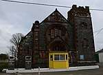 | |||
| Isle Of Whithorn, 60 Main Street | 54°42′00″N 4°21′45″W | Category C(S) | 19235 | | |||
| Isle Of Whithorn, Sea Breeze And Rosnay, With Sea Wall | 54°42′01″N 4°21′49″W | Category C(S) | 19244 | | |||
| Isle Of Whithorn, 56 Main Street | 54°42′00″N 4°21′46″W | Category B | 17071 | | |||
| Isle Of Whithorn, 18 Main Street | 54°42′03″N 4°22′02″W | Category B | 16727 | | |||
| George Street, St Martin And St Ninian Roman Catholic Church, Including Quadrant Walls | 54°43′55″N 4°24′57″W | Category C(S) | 51291 | |
Key
The scheme for classifying buildings in Scotland is:
- Category A: "buildings of national or international importance, either architectural or historic; or fine, little-altered examples of some particular period, style or building type."[1]
- Category B: "buildings of regional or more than local importance; or major examples of some particular period, style or building type, which may have been altered."[1]
- Category C: "buildings of local importance; lesser examples of any period, style, or building type, as originally constructed or moderately altered; and simple traditional buildings which group well with other listed buildings."[1]
In March 2016 there were 47,288 listed buildings in Scotland. Of these, 8% were Category A, and 50% were Category B, with the remaining 42% being Category C.[2]
Notes
- Sometimes known as OSGB36, the grid reference (where provided) is based on the British national grid reference system used by the Ordnance Survey.
• "Guide to National Grid". Ordnance Survey. Retrieved 2007-12-12.
• "Get-a-map". Ordnance Survey. Retrieved 2007-12-17. - Historic Environment Scotland assign a unique alphanumeric identifier to each designated site in Scotland, for listed buildings this always begins with "LB", for example "LB12345".
gollark: Probably a bunch?
gollark: You should make laws for possible cases, especially where it exposes holes.
gollark: They are not known to exist now but good ethical frameworks should consider them generally. (EDIT: in order to not produce "human maximizers" running amok over the universe which don't consider the rights of other possible types of being, which I think would be, er, bad)
gollark: That's... bad.
gollark: How do you know? Why?
References
- All entries, addresses and coordinates are based on data from Historic Scotland. This data falls under the Open Government Licence
- "What is Listing?". Historic Environment Scotland. Retrieved 29 May 2018.
- Scotland's Historic Environment Audit 2016 (PDF). Historic Environment Scotland and the Built Environment Forum Scotland. pp. 15–16. Retrieved 29 May 2018.
This article is issued from Wikipedia. The text is licensed under Creative Commons - Attribution - Sharealike. Additional terms may apply for the media files.