List of listed buildings in Stranraer, Dumfries and Galloway
List
| Name | Location | Date Listed | Grid Ref. [note 1] | Geo-coordinates | Notes | LB Number [note 2] | Image |
|---|---|---|---|---|---|---|---|
| 15 Bridge Street Including Boundary Walls And Gatepiers | 54°54′14″N 5°01′36″W | Category B | 45212 | 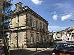 | |||
| 8 And 10 Castle Street | 54°54′16″N 5°01′33″W | Category C(S) | 45214 |  | |||
| 18 And 20 King Street | 54°54′18″N 5°01′49″W | Category A | 45230 | | |||
| London Road, Westwood,Viewfield, And Woodside Cottage Including Boundary Walls, Gatepiers And Railings | 54°54′12″N 5°00′43″W | Category C(S) | 45234 | | |||
| 25 London Road Including Boundary Walls, Gatepiers, Gate And Railings | 54°54′12″N 5°01′05″W | Category B | 45237 | | |||
| London Road, St Andrew's Church (Church Of Scotland) And Graveyard Including Boundary Walls, Gatepiers, Gates And Railings | 54°54′11″N 5°01′15″W | Category B | 45238 | | |||
| 45 And 47 London Road, Wenova And Merslaugh, Including Boundary Walls, Gatepiers, Gates And Railings | 54°54′11″N 5°01′13″W | Category B | 41762 | | |||
| 37 London Road, Helenslea Including Boundary Walls, Gatepiers, Gate Railings And Outhouse To Rear | 54°54′11″N 5°01′10″W | Category B | 41763 | | |||
| 14 King Street | 54°54′19″N 5°01′49″W | Category B | 41770 | | |||
| Off Glebe Street, Park House Stables | 54°54′14″N 5°02′07″W | Category B | 41776 | | |||
| 49 George Street, George Hotel Including Postbox | 54°54′16″N 5°01′41″W | Category B | 41781 | | |||
| 58 George Street, The Golden Cross | 54°54′17″N 5°01′42″W | Category C(S) | 41787 | | |||
| Lewis Street, Lewis Street Gospel Hall | 54°54′07″N 5°01′37″W | Category B | 41755 | | |||
| 2 Hanover Street | 54°54′12″N 5°01′19″W | Category C(S) | 41758 | | |||
| 49 London Road, Brunswick House Including Boundary Walls, Gatepiers, Gate And Railings | 54°54′11″N 5°01′14″W | Category B | 41761 | | |||
| Ailsa Crescent, Darrochmhor Including Boundary Walls And Gatepiers | 54°54′23″N 5°02′21″W | Category C(S) | 45210 | | |||
| 15-21 (Odd Nos) Church Street | 54°54′15″N 5°01′40″W | Category C(S) | 45217 | | |||
| 65-67A George Street (Odd Nos) Including Boundary Walls | 54°54′16″N 5°01′44″W | Category C(S) | 45222 | | |||
| 77 Hanover Street And 1 Hanover Square | 54°54′12″N 5°01′30″W | Category C(S) | 45226 | | |||
| 4 And 6 Hanover Street | 54°54′12″N 5°01′20″W | Category C(S) | 45228 | | |||
| Fisher Street, Wellington House And 5, The Cottage Including Boundary Walls, Gatepiers And Gates | 54°54′19″N 5°01′37″W | Category B | 41769 | | |||
| Leswalt High Road, The High Kirk Of Stranraer (Church Of Scotland) Including Graveyard, Boundary Walls, Gatepiers, Gates And Railings | 54°54′17″N 5°02′02″W | Category B | 41774 | | |||
| 34-38 (Even Nos) George Street | 54°54′17″N 5°01′39″W | Category C(S) | 41782 | | |||
| Church Street, Old Parish Church (Church Of Scotland) Including Lamp Standards | 54°54′15″N 5°01′41″W | Category B | 41743 | | |||
| Dalrymple Street, Reformed Presbyterian Church And Church Hall Including Graveyard, Boundary Walls And Gatepiers | 54°54′11″N 5°01′24″W | Category C(S) | 45218 | | |||
| 57 Hanover Street | 54°54′12″N 5°01′28″W | Category C(S) | 45225 | | |||
| 25 Lewis Street Including Boundary Walls, Gatepiers, Gate And Railings | 54°54′11″N 5°01′37″W | Category C(S) | 45232 | | |||
| Bridge Street, Stranraer Parish Church Hall Including Graveyard And Boundary Walls | 54°54′13″N 5°01′37″W | Category C(S) | 41764 | | |||
| 34 Bridge Street | 54°54′14″N 5°01′39″W | Category C(S) | 41750 | | |||
| London Road, L'Aperitif (Formerly Ivy House) | 54°54′11″N 5°01′18″W | Category B | 41760 | | |||
| Market Street, Harbour Office With Weighbridge | 54°54′22″N 5°01′49″W | Category C(S) | 49655 | | |||
| 8 And 10 Academy Street Including Boundary Walls, Railings And Gate | 54°54′03″N 5°01′26″W | Category C(S) | 45209 | | |||
| 9 Bridge Street, Former Grain Store Including Boundary Walls | 54°54′13″N 5°01′34″W | Category B | 45211 | | |||
| 12 And 14 Castle Street | 54°54′15″N 5°01′33″W | Category C(S) | 45215 | | |||
| 32 Charlotte Street | 54°54′18″N 5°01′30″W | Category C(S) | 45216 | | |||
| 45 And 47 George Street | 54°54′16″N 5°01′40″W | Category C(S) | 45221 | | |||
| 30 George Street | 54°54′17″N 5°01′38″W | Category C(S) | 45223 | | |||
| 89 And 91 Hanover Street | 54°54′13″N 5°01′33″W | Category C(S) | 45227 | | |||
| 8 And 10 George Street | 54°54′17″N 5°01′36″W | Category C(S) | 41766 | | |||
| Glebe Street, Park House Gatepiers And Boundary Walls | 54°54′15″N 5°02′07″W | Category B | 41777 | | |||
| 23, 25 And 27 (Odd Nos) Church Street | 54°54′15″N 5°01′39″W | Category C(S) | 41748 | | |||
| 39 Lewis Street Including Boundary Walls | 54°54′08″N 5°01′35″W | Category B | 41754 | | |||
| 1 Academy Street Including Boundary Walls, Railings And Gate | 54°54′02″N 5°01′24″W | Category B | 41757 | | |||
| South Strand Street, Fountain | 54°54′16″N 5°01′42″W | Category C(S) | 45220 | | |||
| 23 Lewis Street Including Boundary Walls And Gatepier | 54°54′11″N 5°01′37″W | Category C(S) | 45231 | | |||
| London Road, Stair Park Gatepiers And Gates | 54°54′13″N 5°00′49″W | Category C(S) | 45236 | | |||
| Springwell Road, Encliffe House Including Boundary Walls, Gates And Outhouse | 54°54′19″N 5°02′11″W | Category C(S) | 45241 | | |||
| George Street And Castle Street, Stranraer Castle | 54°54′16″N 5°01′34″W | Category A | 41765 | 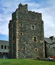 | |||
| 11 Market Street | 54°54′21″N 5°01′44″W | Category C(S) | 41772 | | |||
| Bellevilla Road, Anne House Including Outbuildings, Boundary Walls, Gatepiers, Gates And Railings | 54°54′16″N 5°01′20″W | Category B | 41783 | | |||
| Lewis Street, Sheriff Courthouse Including War Memorial, Gatepiers And Boundary Walls | 54°54′11″N 5°01′38″W | Category B | 41785 | | |||
| Lewis Street, St Ninian's Church (Church Of Scotland) Including Boundary Walls, Gatepiers And Gates | 54°54′11″N 5°01′40″W | Category B | 41786 | | |||
| Church Street, Graveyard Including Boundary Walls And Gate | 54°54′15″N 5°01′41″W | Category B | 41744 | | |||
| 12 Church Street, Formerly Bank Of Scotland | 54°54′14″N 5°01′41″W | Category B | 41746 | | |||
| 6 Lewis Street Including Boundary Walls | 54°54′12″N 5°01′40″W | Category B | 41752 | | |||
| 21 Lewis Street Including Boundary Walls, Gatepiers, Gate And Railings | 54°54′12″N 5°01′37″W | Category C(S) | 41753 | | |||
| London Road, Morland (Formerly Bowie Cottage) Including Boundary Walls And Gatepiers | 54°54′11″N 5°01′19″W | Category C(S) | 41759 | | |||
| 4 And 6 Bridge Street, The Grapes, Including Courtyard Outbuildings At Rear | 54°54′14″N 5°01′33″W | Category C(S) | 51120 | | |||
| 28 And 30 Harbour Street With Warehouse To Rear, Including Boundary Walls | 54°54′20″N 5°01′35″W | Category B | 41768 | | |||
| 85- 89 (Odd Nos) George Street | 54°54′16″N 5°01′47″W | Category C(S) | 41780 | | |||
| 55 George Street, Stranraer Museum Formerly Old Town Hall | 54°54′16″N 5°01′42″W | Category A | 41745 | 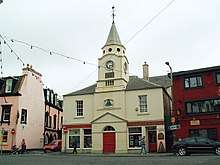 | |||
| 10 Market Street | 54°54′21″N 5°01′44″W | Category C(S) | 41771 | | |||
| 31 Church Street | 54°54′14″N 5°01′40″W | Category B | 41749 | | |||
| 6 Academy Street Including Boundary Walls, Railings And Gate | 54°54′03″N 5°01′25″W | Category C(S) | 41756 | | |||
| Broadstone Road, Briarbrae Including Boundary Walls, Gatepiers, Gate And Garage | 54°54′46″N 5°02′30″W | Category C(S) | 45213 | | |||
| 40-44 (Even Nos) George Street | 54°54′17″N 5°01′40″W | Category C(S) | 45224 | | |||
| 8 Hanover Street | 54°54′12″N 5°01′21″W | Category C(S) | 45229 | | |||
| London Road, Stair Park Bandstand | 54°54′12″N 5°00′45″W | Category B | 45235 | | |||
| 17 North Strand Street | 54°54′18″N 5°01′34″W | Category B | 45239 | | |||
| 5 St John Street | 54°54′17″N 5°01′26″W | Category C(S) | 45240 | | |||
| 2-6 (Even Nos) George Street | 54°54′17″N 5°01′35″W | Category C(S) | 41767 | | |||
| Off Glebe Street, Park House | 54°54′15″N 5°02′07″W | Category B | 41775 | | |||
| 5 And 7 High Street | 54°54′17″N 5°01′50″W | Category C(S) | 41779 | | |||
| Church Street, Dunbae House, Including Boundary Walls, Gatepiers And Railings | 54°54′14″N 5°01′42″W | Category B | 41747 | |
Key
The scheme for classifying buildings in Scotland is:
- Category A: "buildings of national or international importance, either architectural or historic; or fine, little-altered examples of some particular period, style or building type."[1]
- Category B: "buildings of regional or more than local importance; or major examples of some particular period, style or building type, which may have been altered."[1]
- Category C: "buildings of local importance; lesser examples of any period, style, or building type, as originally constructed or moderately altered; and simple traditional buildings which group well with other listed buildings."[1]
In March 2016 there were 47,288 listed buildings in Scotland. Of these, 8% were Category A, and 50% were Category B, with the remaining 42% being Category C.[2]
Notes
- Sometimes known as OSGB36, the grid reference (where provided) is based on the British national grid reference system used by the Ordnance Survey.
• "Guide to National Grid". Ordnance Survey. Retrieved 12 December 2007.
• "Get-a-map". Ordnance Survey. Retrieved 17 December 2007. - Historic Environment Scotland assign a unique alphanumeric identifier to each designated site in Scotland, for listed buildings this always begins with "LB", for example "LB12345".
gollark: Originally it just did... fortunes, I think? Then DDG access.
gollark: I think ABR was written in 2018-2019ish.
gollark: I will physically eat in the next hour or so.
gollark: Yes, I will do this and take some honey along to eat.
gollark: GPS is the American system.
References
- All entries, addresses and coordinates are based on data from Historic Scotland. This data falls under the Open Government Licence
- "What is Listing?". Historic Environment Scotland. Retrieved 29 May 2018.
- Scotland's Historic Environment Audit 2016 (PDF). Historic Environment Scotland and the Built Environment Forum Scotland. pp. 15–16. Retrieved 29 May 2018.
This article is issued from Wikipedia. The text is licensed under Creative Commons - Attribution - Sharealike. Additional terms may apply for the media files.