List of listed buildings in Girthon, Dumfries and Galloway
List
| Name | Location | Date Listed | Grid Ref. [note 1] | Geo-coordinates | Notes | LB Number [note 2] | Image |
|---|---|---|---|---|---|---|---|
| Clauchan Cottage Girthon | 54°51′26″N 4°10′25″W | Category C(S) | 9861 |  | |||
| The Temple, (Cally Estate) | 54°51′50″N 4°10′26″W | Category B | 9851 | | |||
| Disdow And Outbuildings | 54°53′08″N 4°09′36″W | Category C(S) | 9856 | | |||
| Enrick Farmhouse | 54°52′01″N 4°09′32″W | Category B | 9857 | | |||
| High Lodge, (Cally Estate) | 54°52′18″N 4°09′34″W | Category B | 9860 | | |||
| Belvedere Lodge (Cally Estate) | 54°52′07″N 4°10′41″W | Category B | 9865 | | |||
| Girthon Old Kirk And Churchyard | 54°51′21″N 4°10′26″W | Category A | 9859 | 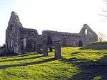 | |||
| Cally Mains Hay Barn | 54°51′47″N 4°11′45″W | Category B | 9853 | | |||
| Dalmalin Lodge | 54°53′58″N 4°11′11″W | Category C(S) | 9863 | | |||
| Cally Palace Hotel, Formerly Cally House | 54°52′11″N 4°11′00″W | Category A | 9854 | | |||
| Furgusson Tombstone | 55°00′45″N 4°11′08″W | Category C(S) | 9858 | | |||
| Kirk House (Former Manse) | 54°51′22″N 4°10′26″W | Category B | 9862 | | |||
| Cally Mains Farm Steading | 54°51′49″N 4°11′43″W | Category B | 9866 | | |||
| Cross Cottage, (Cally Estate) | 54°52′29″N 4°10′41″W | Category B | 9855 | | |||
| Walled Garden, (Calley Estate) | 54°52′12″N 4°10′35″W | Category B | 43278 | | |||
| Auchencloy Monument | 55°00′46″N 4°11′06″W | Category C(S) | 9864 | | |||
| Cally Mains Farmhouse | 54°51′46″N 4°11′50″W | Category B | 9852 | |
Key
The scheme for classifying buildings in Scotland is:
- Category A: "buildings of national or international importance, either architectural or historic; or fine, little-altered examples of some particular period, style or building type."[1]
- Category B: "buildings of regional or more than local importance; or major examples of some particular period, style or building type, which may have been altered."[1]
- Category C: "buildings of local importance; lesser examples of any period, style, or building type, as originally constructed or moderately altered; and simple traditional buildings which group well with other listed buildings."[1]
In March 2016 there were 47,288 listed buildings in Scotland. Of these, 8% were Category A, and 50% were Category B, with the remaining 42% being Category C.[2]
Notes
- Sometimes known as OSGB36, the grid reference (where provided) is based on the British national grid reference system used by the Ordnance Survey.
• "Guide to National Grid". Ordnance Survey. Retrieved 2007-12-12.
• "Get-a-map". Ordnance Survey. Retrieved 2007-12-17. - Historic Environment Scotland assign a unique alphanumeric identifier to each designated site in Scotland, for listed buildings this always begins with "LB", for example "LB12345".
gollark: hello
gollark: <@805534998660775986> <@!258639553357676545>
gollark: h h
gollark: <@805534998660775986> <@!258639553357676545>
gollark: h
References
- All entries, addresses and coordinates are based on data from Historic Scotland. This data falls under the Open Government Licence
- "What is Listing?". Historic Environment Scotland. Retrieved 29 May 2018.
- Scotland's Historic Environment Audit 2016 (PDF). Historic Environment Scotland and the Built Environment Forum Scotland. pp. 15–16. Retrieved 29 May 2018.
| Wikimedia Commons has media related to Girthon. |
This article is issued from Wikipedia. The text is licensed under Creative Commons - Attribution - Sharealike. Additional terms may apply for the media files.