List of listed buildings in Langholm, Dumfries and Galloway
List
| Name | Location | Date Listed | Grid Ref. [note 1] | Geo-coordinates | Notes | LB Number [note 2] | Image |
|---|---|---|---|---|---|---|---|
| Townhead, Eskvale | 55°09′09″N 3°00′02″W | Category B | 37143 |  | |||
| Buccleuch Square, Pump | 55°09′11″N 3°00′14″W | Category B | 37108 | | |||
| Charles Street Old, Langholm Parish Church Hall | 55°09′01″N 3°00′06″W | Category C(S) | 37109 | | |||
| 26, 28, 30 Drove Road | 55°09′00″N 2°59′50″W | Category B | 37113 | | |||
| 1-63 (Inclusive Nos) Eskdaill Street | 55°09′01″N 3°00′30″W | Category B | 37114 | | |||
| 97 High Street | 55°08′59″N 2°59′50″W | Category C(S) | 37126 | | |||
| 12, 14 High Street | 55°09′07″N 3°00′02″W | Category C(S) | 37130 | | |||
| Langholm Lodge (Both Houses) | 55°09′29″N 3°00′42″W | Category B | 9733 | | |||
| Malcolm Monument On Whita Hill | 55°09′09″N 2°58′32″W | Category B | 9762 | | |||
| 9 High Street, Erskine Parish Church | 55°09′08″N 3°00′00″W | Category B | 37117 | | |||
| 15, 17 (Odd Nos) High Street, Buck Hotel Including Barn At Rear | 55°09′07″N 3°00′00″W | Category C(S) | 37119 | | |||
| High Street, Statue Of Sir Pulteney Malcolm (In Library Garden) | 55°09′02″N 2°59′53″W | Category C(S) | 37124 | | |||
| High Street, Ashley Bank Hotel, Lodge And Retaining Walls | 55°08′58″N 2°59′47″W | Category B | 37128 | | |||
| Broomholm House And Gatepiers | 55°07′30″N 2°59′08″W | Category B | 9752 | | |||
| Broomholm House, Sundial | 55°07′32″N 2°59′05″W | Category B | 9753 | | |||
| Thomas Telford Road, Langholm Academy (Block On South Side Of Road) | 55°09′12″N 3°00′23″W | Category B | 37141 | | |||
| Townhead, Clinthead | 55°09′10″N 3°00′02″W | Category B | 37144 | | |||
| 11 High Street, Townhead House | 55°09′08″N 3°00′01″W | Category B | 37118 | | |||
| High Street, Town House | 55°09′02″N 2°59′54″W | Category B | 37122 | | |||
| 30 High Street/2 John Street, Bank Of Scotland Building | 55°09′06″N 3°00′00″W | Category B | 37131 | | |||
| 74-80 (Even Nos) High Street | 55°09′02″N 2°59′55″W | Category C(S) | 37134 | | |||
| High Street, Tollbar Cottage South | 55°08′55″N 2°59′41″W | Category B | 37135 | | |||
| Ewesbank House And Adjoining Cottage, Workshops/Stores | 55°09′23″N 3°00′03″W | Category B | 9757 | | |||
| Staplegordon Old Churchyard | 55°10′53″N 3°01′08″W | Category B | 9719 | | |||
| Townhead, Tollbar Cottage North | 55°09′12″N 3°00′01″W | Category B | 37145 | | |||
| Suspension Bridge (Boatford Bridge) | 55°09′03″N 3°00′08″W | Category B | 37139 | | |||
| Thomas Telford Road, The Holm | 55°09′11″N 3°00′16″W | Category C(S) | 37140 | | |||
| Townhead, Bridge (B709 Over River Esk) | 55°09′09″N 3°00′04″W | Category B | 37146 | | |||
| High Street, Crown Hotel | 55°09′06″N 2°59′58″W | Category B | 37121 | | |||
| High Street, Telford Doorcase Or Gateway (In Library Garden) | 55°09′02″N 2°59′53″W | Category B | 37125 | | |||
| Langholm Old Churchyard | 55°09′07″N 2°59′52″W | Category C(S) | 37136 | | |||
| Langholm Parish Church, Driveway Bridge, Gates And Gatepiers | 55°09′03″N 3°00′10″W | Category B | 37138 | | |||
| Langholm Lodge, Duchess Bridge (Over River Esk) | 55°09′26″N 3°00′44″W | Category A | 9734 | 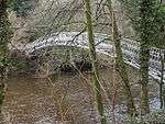 | |||
| Longwood Cottage And Outbuilding With Glass House | 55°08′15″N 2°59′14″W | Category B | 9761 | | |||
| Milnholm Farmhouse And Steading | 55°10′32″N 3°00′50″W | Category A | 9763 | | |||
| Thomas Telford Road, Schoolhouse | 55°09′12″N 3°00′16″W | Category B | 37142 | | |||
| David Street, Thomas Hope Hospital, Hospital Lodge, Mortuary And Enclosure Walls, Gates And Railings | 55°09′03″N 2°59′57″W | Category B | 37110 | | |||
| Ewes Bridge (Over Ewes Water) | 55°09′20″N 3°00′04″W | Category B | 37115 | | |||
| 56 High Street And The Edinburgh Woollen Mill Shop, Market Place | 55°09′04″N 2°59′57″W | Category C(S) | 37132 | | |||
| Langholm Parish Church | 55°09′01″N 3°00′12″W | Category A | 37137 | 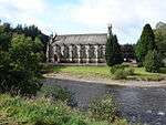 | |||
| Broomholm House ,Steading And Former Stables | 55°07′34″N 2°59′05″W | Category B | 9754 | | |||
| Highmill Bridge (A7 Over Ewes Water) | 55°09′46″N 2°59′32″W | Category B | 9758 | | |||
| Langholm Lodge, Episcopal Church | 55°09′24″N 3°00′12″W | Category B | 9760 | | |||
| Skipper's Bridge (A7 Over River Esk) | 55°08′27″N 2°59′20″W | Category A | 9764 | 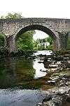 | |||
| Springhill (Former Wauchope Manse) | 55°08′52″N 3°00′44″W | Category C(S) | 9765 | | |||
| 8 Buccleuch Square, Hamnavoe | 55°09′11″N 3°00′16″W | Category C(S) | 37107 | | |||
| House To South Of 12 Drove Road, Fronting Un-Named Close | 55°09′06″N 2°59′55″W | Category C(S) | 37112 | | |||
| Glenesk Road, Waverley Mills | 55°08′50″N 2°59′50″W | Category B | 37116 | | |||
| Cleuchfoot | 55°08′06″N 3°04′35″W | Category B | 9755 | | |||
| Wauchope Churchyard | 55°08′49″N 3°00′47″W | Category B | 9720 | | |||
| Buccleuch Square, Police Station Building | 55°09′10″N 3°00′16″W | Category B | 37106 | | |||
| Drove Road, House Opposite Number 26 | 55°09′00″N 2°59′49″W | Category C(S) | 37111 | | |||
| High Street, Royal Bank Of Scotland Building | 55°09′06″N 2°59′58″W | Category C(S) | 37120 | | |||
| High Street, Library | 55°09′02″N 2°59′54″W | Category B | 37123 | | |||
| High Street, Buccleuch House | 55°08′59″N 2°59′49″W | Category B | 37127 | | |||
| 10 High Street, Bridge House | 55°09′08″N 3°00′02″W | Category C(S) | 37129 | | |||
| High Street, Eskdale Hotel | 55°09′02″N 2°59′56″W | Category B | 37133 | |
Key
The scheme for classifying buildings in Scotland is:
- Category A: "buildings of national or international importance, either architectural or historic; or fine, little-altered examples of some particular period, style or building type."[1]
- Category B: "buildings of regional or more than local importance; or major examples of some particular period, style or building type, which may have been altered."[1]
- Category C: "buildings of local importance; lesser examples of any period, style, or building type, as originally constructed or moderately altered; and simple traditional buildings which group well with other listed buildings."[1]
In March 2016 there were 47,288 listed buildings in Scotland. Of these, 8% were Category A, and 50% were Category B, with the remaining 42% being Category C.[2]
Notes
- Sometimes known as OSGB36, the grid reference (where provided) is based on the British national grid reference system used by the Ordnance Survey.
• "Guide to National Grid". Ordnance Survey. Retrieved 2007-12-12.
• "Get-a-map". Ordnance Survey. Retrieved 2007-12-17. - Historic Environment Scotland assign a unique alphanumeric identifier to each designated site in Scotland, for listed buildings this always begins with "LB", for example "LB12345".
gollark: Masks are almost certainly in the "worth it" box, since the only major downside is that... masks are somewhat expensive?
gollark: I mean, generally speaking, because sometimes preventing people from dying now incurs significant costs of various kinds.
gollark: I don't wear masks, although I would if I actually *had any* and was going out.
gollark: "we can't immediately totally fix it and it's not a problem which has affected me yet so let's ignore it"
gollark: That is a... food product or something... which exists, alright.
References
- All entries, addresses and coordinates are based on data from Historic Scotland. This data falls under the Open Government Licence
- "What is Listing?". Historic Environment Scotland. Retrieved 29 May 2018.
- Scotland's Historic Environment Audit 2016 (PDF). Historic Environment Scotland and the Built Environment Forum Scotland. pp. 15–16. Retrieved 29 May 2018.
This article is issued from Wikipedia. The text is licensed under Creative Commons - Attribution - Sharealike. Additional terms may apply for the media files.