List of listed buildings in Kirkmaiden, Dumfries and Galloway
This is a list of listed buildings in the civil parish of Kirkmaiden, in Dumfries and Galloway, Scotland.
List
| Name | Location | Date Listed | Grid Ref. [note 1] | Geo-coordinates | Notes | LB Number [note 2] | Image |
|---|---|---|---|---|---|---|---|
| Terally, Tile Works Cottages | 54°43′32″N 4°55′18″W | Category B | 13592 |  | |||
| K6 Telephone Kiosk, At Gateway To Mull School | 54°39′45″N 4°54′04″W | Category B | 13557 | | |||
| Kirkbride, Farmhouse And Steading | 54°43′13″N 4°55′31″W | Category C(S) | 13560 | | |||
| Logan, Logan Botanic Garden | 54°44′30″N 4°57′36″W | Category B | 13565 | 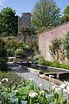 | |||
| Low Currochtrie, Farmhouse | 54°41′50″N 4°55′06″W | Category C(S) | 13573 | | |||
| Mull Of Galloway Lighthouse, Lighthouse Keepers' Houses And Boundary Walls | 54°38′06″N 4°51′26″W | Category A | 13578 | 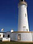 | |||
| Drummore, 5 Shore Street, Ship Inn | 54°41′28″N 4°53′36″W | Category C(S) | 10101 | | |||
| East Tarbet, Cottage And Quay | 54°38′22″N 4°52′35″W | Category B | 10126 | | |||
| Drummore, 19 Shore Street | 54°41′29″N 4°53′40″W | Category B | 10131 | | |||
| Kennedy's Cairn | 54°38′08″N 4°52′25″W | Category C(S) | 13558 | | |||
| Logan, Bridge | 54°44′08″N 4°57′49″W | Category C(S) | 13561 | | |||
| Low Drummore, Farmhouse | 54°41′17″N 4°53′41″W | Category C(S) | 13574 | | |||
| Mull Hill, Beacon | 54°44′13″N 4°59′10″W | Category C(S) | 13575 | | |||
| Port Logan, Laigh Row, Port Logan Lodge | 54°43′25″N 4°57′22″W | Category C(S) | 13585 | | |||
| Drummore, 17 Mill Street, Ingleston | 54°41′22″N 4°53′43″W | Category C(S) | 10090 | | |||
| Drummore, 33 Mill Street | 54°41′23″N 4°53′41″W | Category C(S) | 10096 | | |||
| Terally Brick And Tile Works | 54°43′35″N 4°55′13″W | Category B | 13590 | | |||
| Longbows (Former Drummore School And Schoolhouse) | 54°41′34″N 4°54′19″W | Category C(S) | 13571 | | |||
| Port Logan Lighthouse Tower And Pier | 54°43′26″N 4°57′36″W | Category B | 13586 | | |||
| St Agnes's (Former) Church And Manse, With Railings | 54°45′08″N 4°56′08″W | Category B | 13589 | | |||
| Drummore, 41 Mill Street | 54°41′24″N 4°53′39″W | Category C(S) | 10097 | | |||
| Drummore, 36 And 38 Stair Street, With Railings, Gates And Gatepiers | 54°41′31″N 4°53′48″W | Category C(S) | 10124 | | |||
| Terally Brick, Coal Store | 54°43′47″N 4°55′00″W | Category C(S) | 13591 | | |||
| Logan Mills, Fishing Store | 54°45′12″N 4°55′43″W | Category C(S) | 13568 | | |||
| Port Logan, Laigh Row (Mr Davey) | 54°43′24″N 4°57′24″W | Category C(S) | 13584 | | |||
| Drummore, 57 Mill Street, Warehouse | 54°41′28″N 4°53′34″W | Category C(S) | 10098 | | |||
| Drummore, 13 Shore Street, Norwood | 54°41′29″N 4°53′39″W | Category B | 10103 | | |||
| Drummore, 15 Shore Street, Anwoth | 54°41′29″N 4°53′39″W | Category B | 10129 | | |||
| Logan, Hen Knowe Cottages | 54°44′46″N 4°57′43″W | Category C(S) | 13563 | | |||
| Logan Mills, Sawmill, With Water-Wheel | 54°45′07″N 4°55′46″W | Category B | 13569 | | |||
| Logan Windmill | 54°45′13″N 4°55′50″W | Category A | 13570 | 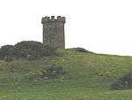 | |||
| Mullhill, Farmhouse | 54°44′18″N 4°58′54″W | Category C(S) | 13576 | | |||
| Mull School And Schoolhouse | 54°39′46″N 4°54′05″W | Category C(S) | 13579 | | |||
| Old Parish Church Of Kirkmaiden, With Graveyard, Graveyard Walls And Gatepiers | 54°41′32″N 4°54′42″W | Category A | 13581 | 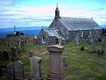 | |||
| Port Logan, 15 Laigh Row | 54°43′23″N 4°57′25″W | Category C(S) | 13583 | | |||
| Balgowan, Farmhouse | 54°44′53″N 4°55′58″W | Category B | 10086 | | |||
| Chapel Rossan | 54°45′53″N 4°56′27″W | Category B | 10088 | | |||
| Drummore, 29 And 31 Mill Street, Queen's Hotel | 54°41′23″N 4°53′41″W | Category B | 10092 | | |||
| Drummore, Saint Medan's Church Boundary Walls, Railings, Gates And War Memorial | 54°41′27″N 4°53′44″W | Category B | 10100 | | |||
| Drummore, 40 Stair Street | 54°41′31″N 4°53′49″W | Category C(S) | 10125 | | |||
| Logan, Logan Court (Former Coach House And Stables) | 54°44′46″N 4°57′34″W | Category B | 13566 | | |||
| Port Logan School | 54°43′47″N 4°57′21″W | Category C(S) | 13587 | | |||
| Castle Clanyard | 54°41′46″N 4°56′12″W | Category C(S) | 10087 | | |||
| Drummore, Mill Street, Wylie's Mill, With Water-Wheel | 54°41′27″N 4°53′33″W | Category C(S) | 10089 | | |||
| Drummore, 17 Shore Street | 54°41′29″N 4°53′40″W | Category B | 10130 | | |||
| Drummore, Stair Street, Lamb Monument | 54°41′27″N 4°53′43″W | Category C(S) | 10132 | | |||
| Logan, Folly Tower | 54°44′39″N 4°57′53″W | Category C(S) | 13562 | | |||
| Low Clanyard, Farmhouse | 54°41′46″N 4°56′20″W | Category B | 13572 | | |||
| Old Kirkmaiden House (Former Manse) | 54°41′40″N 4°54′58″W | Category B | 13580 | | |||
| Port Logan, 14 Laigh Row | 54°43′23″N 4°57′25″W | Category C(S) | 13582 | | |||
| Port Logan Schoolhouse | 54°43′49″N 4°57′19″W | Category C(S) | 13588 | | |||
| Drummore, 19 Mill Street | 54°41′22″N 4°53′43″W | Category C(S) | 10091 | | |||
| Drummore, 4 Mill Street, Cairnsmore | 54°41′20″N 4°53′44″W | Category C(S) | 10099 | | |||
| Killumpha, Farmhouse | 54°43′34″N 4°55′57″W | Category B | 13559 | | |||
| Logan House | 54°44′39″N 4°57′32″W | Category A | 13564 | .jpg) | |||
| Logan, Logan Fish Pond, Cottage And Bathing Hut | 54°43′50″N 4°57′53″W | Category B | 13567 | | |||
| Auchness, Farmhouse And Cottage | 54°45′37″N 4°56′38″W | Category B | 10085 | | |||
| Drummore, 11 Shore Street, Tudor House | 54°41′29″N 4°53′38″W | Category B | 10102 | |
Key
The scheme for classifying buildings in Scotland is:
- Category A: "buildings of national or international importance, either architectural or historic; or fine, little-altered examples of some particular period, style or building type."[1]
- Category B: "buildings of regional or more than local importance; or major examples of some particular period, style or building type, which may have been altered."[1]
- Category C: "buildings of local importance; lesser examples of any period, style, or building type, as originally constructed or moderately altered; and simple traditional buildings which group well with other listed buildings."[1]
In March 2016 there were 47,288 listed buildings in Scotland. Of these, 8% were Category A, and 50% were Category B, with the remaining 42% being Category C.[2]
Notes
- Sometimes known as OSGB36, the grid reference (where provided) is based on the British national grid reference system used by the Ordnance Survey.
• "Guide to National Grid". Ordnance Survey. Retrieved 2007-12-12.
• "Get-a-map". Ordnance Survey. Retrieved 2007-12-17. - Historic Environment Scotland assign a unique alphanumeric identifier to each designated site in Scotland, for listed buildings this always begins with "LB", for example "LB12345".
gollark: Wait, what's the unlabelled end?
gollark: extremely boring idea: Brain[REDACTED] encoded using frequency shift keying.
gollark: indecipherable squiggle indecipherable squiggle indecipherable squiggle a indecipherable squiggle h
gollark: open curly bracket standard colon colon c out less than less than double quote hello world double quote semicolon close bracket
gollark: integer main open bracket integer argument count comma char star star argument vector close bracket
References
- All entries, addresses and coordinates are based on data from Historic Scotland. This data falls under the Open Government Licence
- "What is Listing?". Historic Environment Scotland. Retrieved 29 May 2018.
- Scotland's Historic Environment Audit 2016 (PDF). Historic Environment Scotland and the Built Environment Forum Scotland. pp. 15–16. Retrieved 29 May 2018.
This article is issued from Wikipedia. The text is licensed under Creative Commons - Attribution - Sharealike. Additional terms may apply for the media files.