List of listed buildings in Lockerbie, Dumfries and Galloway
List
| Name | Location | Date Listed | Grid Ref. [note 1] | Geo-coordinates | Notes | LB Number [note 2] | Image |
|---|---|---|---|---|---|---|---|
| High Street, War Memorial | 55°07′19″N 3°21′19″W | Category B | 37563 |  | |||
| 78, 80 High Street | 55°07′19″N 3°21′19″W | Category C(S) | 37576 | | |||
| 82-88 (Even Nos) High Street | 55°07′19″N 3°21′18″W | Category C(S) | 37577 | | |||
| 75 Mains Street | 55°07′02″N 3°21′22″W | Category B | 37585 | | |||
| 14 And 16 Main Street, Masonic Hall | 55°07′10″N 3°21′21″W | Category C(S) | 49584 | | |||
| 2, 3 Ferguson Place | 55°07′21″N 3°20′57″W | Category B | 37562 | | |||
| 77, 79 High Street | 55°07′16″N 3°21′21″W | Category B | 37573 | | |||
| 108, 110 High Street | 55°07′16″N 3°21′19″W | Category C(S) | 37581 | | |||
| Arthur's Place, St George's Villa, Including Gatepiers | 55°07′11″N 3°21′26″W | Category B | 37557 | | |||
| Ashgrove Terrace, All Saints Episcopal Church | 55°07′23″N 3°21′36″W | Category B | 37558 | | |||
| 29 High Street, King's Arms Hotel | 55°07′20″N 3°21′22″W | Category C(S) | 37569 | | |||
| 81, 83 High Street, Bank Of Scotland | 55°07′16″N 3°21′21″W | Category B | 37574 | | |||
| 1, 3 And 5 Station Road, Tower Buildings | 55°07′19″N 3°21′16″W | Category B | 37578 | | |||
| High Street, Town Hall | 55°07′18″N 3°21′17″W | Category A | 37579 | 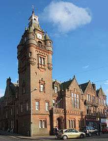 | |||
| Lockerbie Auction Mart | 55°07′32″N 3°21′10″W | Category B | 37583 | | |||
| 11 St Bryde's Terrace, Dryfemount, Including Gatepiers | 55°07′14″N 3°21′32″W | Category B | 37587 | | |||
| 13 St Bryde's Terrace, Fairfield | 55°07′13″N 3°21′31″W | Category B | 37588 | | |||
| 7-11 (Odd Nos) High Street | 55°07′22″N 3°21′23″W | Category C(S) | 37565 | | |||
| 21, 23 High Street, Rogerson And Jamieson | 55°07′21″N 3°21′22″W | Category B | 37567 | | |||
| 55 High Street, Abbey National | 55°07′18″N 3°21′20″W | Category B | 37572 | | |||
| Station Square Lockerbie Station | 55°07′20″N 3°21′14″W | Category B | 37590 | | |||
| 21-27 (Odd Nos) Townhead Street | 55°07′29″N 3°21′25″W | Category B | 37591 | | |||
| 92, 94, 96 High Street | 55°07′18″N 3°21′18″W | Category B | 37580 | | |||
| 44 Mains Street, The Old Manse, Including Boundary Walls And Outbuilding | 55°07′06″N 3°21′22″W | Category B | 37586 | | |||
| Carlisle Road, Somerton House Hotel, Including Gatepiers | 55°06′44″N 3°21′19″W | Category B | 37561 | | |||
| 15, 17 High Street | 55°07′22″N 3°21′23″W | Category C(S) | 37566 | | |||
| 43 High Street | 55°07′19″N 3°21′21″W | Category C(S) | 37570 | | |||
| 47, 49 High Street, Royal Bank Of Scotland | 55°07′19″N 3°21′20″W | Category C(S) | 37571 | | |||
| Arthur's Place, Holy Trinity Roman Catholic Church | 55°07′13″N 3°21′22″W | Category B | 37556 | | |||
| Bridge Street, Library | 55°07′18″N 3°21′16″W | Category B | 37559 | | |||
| Bridge Street, St Cuthbert's Church And Hall (Church Of Scotland) | 55°07′18″N 3°21′07″W | Category B | 37560 | | |||
| High Street, Dryfesdale And Trinity Parish Church, Churchyard And Lodge (Church Of Scotland) | 55°07′25″N 3°21′25″W | Category B | 37564 | | |||
| 25, 27 High Street, Clydesdale Bank | 55°07′21″N 3°21′22″W | Category B | 37568 | | |||
| 10 High Street, Dryfesdale Parish Church Hall | 55°07′24″N 3°21′22″W | Category B | 37575 | | |||
| 27 Mains Street | 55°07′09″N 3°21′23″W | Category C(S) | 37584 | | |||
| 112 High Street, Blue Bell Hotel | 55°07′16″N 3°21′20″W | Category B | 37582 | | |||
| Station Road, Black Bull Inn | 55°07′19″N 3°21′16″W | Category C(S) | 37589 | |
Key
The scheme for classifying buildings in Scotland is:
- Category A: "buildings of national or international importance, either architectural or historic; or fine, little-altered examples of some particular period, style or building type."[1]
- Category B: "buildings of regional or more than local importance; or major examples of some particular period, style or building type, which may have been altered."[1]
- Category C: "buildings of local importance; lesser examples of any period, style, or building type, as originally constructed or moderately altered; and simple traditional buildings which group well with other listed buildings."[1]
In March 2016 there were 47,288 listed buildings in Scotland. Of these, 8% were Category A, and 50% were Category B, with the remaining 42% being Category C.[2]
Notes
- Sometimes known as OSGB36, the grid reference (where provided) is based on the British national grid reference system used by the Ordnance Survey.
• "Guide to National Grid". Ordnance Survey. Retrieved 12 December 2007.
• "Get-a-map". Ordnance Survey. Retrieved 17 December 2007. - Historic Environment Scotland assign a unique alphanumeric identifier to each designated site in Scotland, for listed buildings this always begins with "LB", for example "LB12345".
gollark: No, which is probably for the best.
gollark: This is called an "autoformatter" and it already "exists".
gollark: Try knowing Macron more.
gollark: Unfortunately, the macro is 1.3GB, although it *is* very elegant.
gollark: Although it *is* impressive that it's possible to express the entire text editing workflow in one glorious macro.
References
- All entries, addresses and coordinates are based on data from Historic Scotland. This data falls under the Open Government Licence
- "What is Listing?". Historic Environment Scotland. Retrieved 29 May 2018.
- Scotland's Historic Environment Audit 2016 (PDF). Historic Environment Scotland and the Built Environment Forum Scotland. pp. 15–16. Retrieved 29 May 2018.
This article is issued from Wikipedia. The text is licensed under Creative Commons - Attribution - Sharealike. Additional terms may apply for the media files.