List of listed buildings in Rerrick, Dumfries and Galloway
This is a list of listed buildings in the civil parish of Rerrick, in Dumfries and Galloway, Scotland.
List
| Name | Location | Date Listed | Grid Ref. [note 1] | Geo-coordinates | Notes | LB Number [note 2] | Image |
|---|---|---|---|---|---|---|---|
| Dundrennan Old School And Adjoining School House | 54°48′31″N 3°56′54″W | Category B | 17074 |  | |||
| Orchardton House | 54°51′33″N 3°51′15″W | Category B | 17079 | | |||
| Auchencairn, 45-47 (Odd Nos) Main Street | 54°50′33″N 3°52′27″W | Category C(S) | 17103 | | |||
| Auchencairn, 49-51 (Odd Nos) Main Street | 54°50′32″N 3°52′28″W | Category C(S) | 17104 | | |||
| Balcary Tower | 54°49′38″N 3°49′40″W | Category C(S) | 14880 | | |||
| Hazelfield House | 54°49′20″N 3°54′23″W | Category B | 17077 | | |||
| Auchencairn, 53 Main Street, (Kirkbrae) | 54°50′32″N 3°52′29″W | Category C(S) | 17105 | | |||
| Balcary Lifeboat Station | 54°49′32″N 3°49′34″W | Category B | 17112 | | |||
| Auchencairn, 6 And 8 Crocket Road | 54°50′40″N 3°52′21″W | Category C(S) | 17121 | | |||
| Auchencairn, Main Street, Blairmae | 54°50′30″N 3°52′31″W | Category C(S) | 17122 | | |||
| Auchencairn, 29 Main Street And 2 Wellwood Terrace | 54°50′37″N 3°52′24″W | Category C(S) | 19800 | | |||
| Auchencairn, Craignair | 54°50′32″N 3°52′19″W | Category C(S) | 17083 | | |||
| Port Mary House | 54°47′17″N 3°56′36″W | Category B | 17087 | | |||
| Rerrick Old Churchyard And Ruins Of Old Church | 54°48′00″N 3°55′49″W | Category B | 17088 | | |||
| Auchencairn, Mclure House | 54°50′35″N 3°52′25″W | Category C(S) | 17108 | | |||
| Auchencairn, The Smugglers Inn | 54°50′37″N 3°52′18″W | Category B | 17109 | | |||
| Dundrennan Parish Church Church Of Scotland | 54°48′32″N 3°56′53″W | Category B | 17075 | | |||
| Dundrennan Abbey | 54°48′24″N 3°56′50″W | Category A | 17072 | 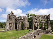 | |||
| Auchencairn, Former Commercial Hotel | 54°50′36″N 3°52′21″W | Category B | 17081 | | |||
| Auchencairn Church, Church Of Scotland | 54°50′31″N 3°52′17″W | Category B | 17082 | | |||
| Auchencairn Lodge And Gatepiers To Auchencairn House | 54°50′03″N 3°50′30″W | Category B | 17111 | | |||
| Auchencairn, 61 And 63 Main Street And Boundary Walls, (Viewfield And Kirklee) | 54°50′30″N 3°52′31″W | Category C(S) | 17106 | | |||
| Auchencairn House | 54°49′54″N 3°50′32″W | Category B | 17110 | | |||
| Orroland House | 54°47′59″N 3°54′38″W | Category B | 17086 | | |||
| Dundrennan Bridge Over Abbey Burn One Quarter Of A Mile North East Of Dundrennan Abbey | 54°48′32″N 3°56′40″W | Category B | 17073 | | |||
| Dundrennan Village Rerrickfield | 54°48′23″N 3°56′56″W | Category B | 17076 | | |||
| Orchardton House Stables | 54°51′31″N 3°51′19″W | Category B | 17085 | | |||
| Auchencairn, 31 Main Street | 54°50′35″N 3°52′23″W | Category C(S) | 17102 | | |||
| Auchencairn, Main Street, Solwayside Guest House | 54°50′35″N 3°52′22″W | Category B | 17107 | | |||
| Collin House | 54°51′06″N 3°52′49″W | Category B | 17113 | |
Key
The scheme for classifying buildings in Scotland is:
- Category A: "buildings of national or international importance, either architectural or historic; or fine, little-altered examples of some particular period, style or building type."[1]
- Category B: "buildings of regional or more than local importance; or major examples of some particular period, style or building type, which may have been altered."[1]
- Category C: "buildings of local importance; lesser examples of any period, style, or building type, as originally constructed or moderately altered; and simple traditional buildings which group well with other listed buildings."[1]
In March 2016 there were 47,288 listed buildings in Scotland. Of these, 8% were Category A, and 50% were Category B, with the remaining 42% being Category C.[2]
Notes
- Sometimes known as OSGB36, the grid reference (where provided) is based on the British national grid reference system used by the Ordnance Survey.
• "Guide to National Grid". Ordnance Survey. Retrieved 2007-12-12.
• "Get-a-map". Ordnance Survey. Retrieved 2007-12-17. - Historic Environment Scotland assign a unique alphanumeric identifier to each designated site in Scotland, for listed buildings this always begins with "LB", for example "LB12345".
gollark: I typed this with my eyes closed and it came out surprisingly not wrongly.
gollark: Wow, that was actually *right*?
gollark: You know what they say, bees approach you at 87THz and you cannot possibly hope to escape, due to the unlimited power of typing .
gollark: Ah, touch typing.
gollark: Just because you don't need 481 zero-ohm resistors on a chip doesn't mean nobody does.
References
- All entries, addresses and coordinates are based on data from Historic Scotland. This data falls under the Open Government Licence
- "What is Listing?". Historic Environment Scotland. Retrieved 29 May 2018.
- Scotland's Historic Environment Audit 2016 (PDF). Historic Environment Scotland and the Built Environment Forum Scotland. pp. 15–16. Retrieved 29 May 2018.
This article is issued from Wikipedia. The text is licensed under Creative Commons - Attribution - Sharealike. Additional terms may apply for the media files.