List of listed buildings in Kelton, Dumfries and Galloway
List
| Name | Location | Date Listed | Grid Ref. [note 1] | Geo-coordinates | Notes | LB Number [note 2] | Image |
|---|---|---|---|---|---|---|---|
| Slatehole | 54°55′11″N 3°57′34″W | Category B | 9827 |  | |||
| Billies Farmhouse | 54°53′39″N 3°59′25″W | Category B | 9833 | | |||
| Douglas Mausoleum, Near To Kelton Parish Church, Railings And Gatepiers | 54°55′20″N 3°56′18″W | Category A | 9835 | 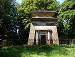 | |||
| Gelston Castle Estate, Gelston Coach House And Gatepiers | 54°54′13″N 3°54′35″W | Category B | 9837 | | |||
| Kelton Old Church In Old Churchyard | 54°55′15″N 3°56′05″W | Category C(S) | 9821 | | |||
| Kelton Parish Church | 54°55′17″N 3°56′15″W | Category B | 9822 | | |||
| Ingleston | 54°54′05″N 3°54′55″W | Category B | 9817 | | |||
| Rhonehouse, Rodney House | 54°55′02″N 3°57′48″W | Category C(S) | 9826 | | |||
| Threave Bridge | 54°55′18″N 3°58′18″W | Category B | 9828 | | |||
| Kelton Mill, Byre | 54°55′17″N 3°57′32″W | Category C(S) | 9820 | | |||
| Threave House | 54°55′22″N 3°56′51″W | Category B | 9829 | 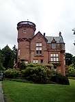 | |||
| Threave Stables | 54°55′29″N 3°56′56″W | Category B | 9830 | | |||
| Dildawn House And Walled Garden | 54°54′43″N 3°59′13″W | Category B | 9834 | | |||
| Old Bridge Of Dee | 54°55′06″N 3°58′34″W | Category A | 9838 | .jpg) | |||
| Kelton Mains Farm | 54°56′03″N 3°57′33″W | Category B | 9818 | | |||
| Airieland Farm House | 54°53′40″N 3°56′20″W | Category B | 9831 | | |||
| Gelston Castle | 54°54′17″N 3°54′31″W | Category A | 9836 | 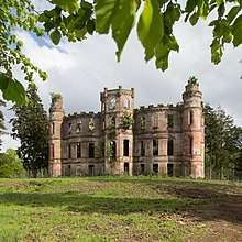 | |||
| Gelston Castle Estate, Gelston Stables And Walled Gardens | 54°54′14″N 3°54′34″W | Category B | 9816 | 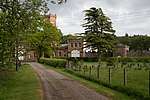 | |||
| Kelton Mill | 54°55′18″N 3°57′31″W | Category C(S) | 9819 | | |||
| Rhonehouse, Creaghlas | 54°55′03″N 3°57′46″W | Category C(S) | 9824 | | |||
| Rhonehouse Of Kelton, Millhill | 54°55′03″N 3°57′44″W | Category B | 9825 | | |||
| Rhonehouse, An Teallach | 54°55′00″N 3°57′49″W | Category C(S) | 9823 | | |||
| Airieland House | 54°53′42″N 3°56′14″W | Category B | 9832 | |
Key
The scheme for classifying buildings in Scotland is:
- Category A: "buildings of national or international importance, either architectural or historic; or fine, little-altered examples of some particular period, style or building type."[1]
- Category B: "buildings of regional or more than local importance; or major examples of some particular period, style or building type, which may have been altered."[1]
- Category C: "buildings of local importance; lesser examples of any period, style, or building type, as originally constructed or moderately altered; and simple traditional buildings which group well with other listed buildings."[1]
In March 2016 there were 47,288 listed buildings in Scotland. Of these, 8% were Category A, and 50% were Category B, with the remaining 42% being Category C.[2]
Notes
- Sometimes known as OSGB36, the grid reference (where provided) is based on the British national grid reference system used by the Ordnance Survey.
• "Guide to National Grid". Ordnance Survey. Retrieved 2007-12-12.
• "Get-a-map". Ordnance Survey. Retrieved 2007-12-17. - Historic Environment Scotland assign a unique alphanumeric identifier to each designated site in Scotland, for listed buildings this always begins with "LB", for example "LB12345".
gollark: Also, it was sold.
gollark: You do not have 10000KST.
gollark: <@97888022359470080> Basically, it's lots of krist because people who got in early and/or were on the last switchcraft are ridiculously rich, partly due to ridiculous block values built into the krist system.
gollark: Obviously it'd have to be rounded, so let's go for a flat 0.
gollark: 0.3KST?
References
- All entries, addresses and coordinates are based on data from Historic Scotland. This data falls under the Open Government Licence
- "What is Listing?". Historic Environment Scotland. Retrieved 29 May 2018.
- Scotland's Historic Environment Audit 2016 (PDF). Historic Environment Scotland and the Built Environment Forum Scotland. pp. 15–16. Retrieved 29 May 2018.
This article is issued from Wikipedia. The text is licensed under Creative Commons - Attribution - Sharealike. Additional terms may apply for the media files.