List of listed buildings in Newton Stewart, Dumfries and Galloway
This is a list of listed buildings in the town of Newton Stewart, in Dumfries and Galloway, Scotland.
List
| Name | Location | Date Listed | Grid Ref. [note 1] | Geo-coordinates | Notes | LB Number [note 2] | Image |
|---|---|---|---|---|---|---|---|
| 19-21 Albert Street | 54°57′24″N 4°28′58″W | Category C(S) | 38654 |  | |||
| Corvisel Road, Lynwood And Railings | 54°57′17″N 4°29′11″W | Category C(S) | 38666 | | |||
| Cree Bridge | 54°57′36″N 4°28′57″W | Category A | 38667 | 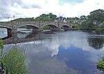 | |||
| King Street Corsbie West | 54°57′55″N 4°29′19″W | Category B | 38671 | | |||
| Penkiln Suspension Footbridge | 54°58′01″N 4°29′08″W | Category B | 38675 | | |||
| 101 And 102 Queen Street, The Crown Hotel | 54°57′12″N 4°28′55″W | Category C(S) | 38682 | | |||
| 36-38 (Even Nos) Victoria Street | 54°57′48″N 4°29′08″W | Category C(S) | 38695 | | |||
| 11 Dashwood Square, Star Inn | 54°57′22″N 4°29′00″W | Category C(S) | 38653 | | |||
| Church Street, Penninghame Graveyard With Mausoleum | 54°57′25″N 4°29′07″W | Category B | 38662 | | |||
| 2, 4, 6 Princes Street And 1 Dashwood Square | 54°57′21″N 4°29′04″W | Category B | 38676 | | |||
| Princes Street, Glenkiel House Former Penninghame Manse With Coach House, Gates, Gatepiers And Railings | 54°57′19″N 4°29′13″W | Category B | 38677 | | |||
| Princes Street, Former Uf Manse | 54°57′19″N 4°29′08″W | Category C(S) | 38679 | | |||
| 1 Victoria Street | 54°57′27″N 4°28′57″W | Category B | 38684 | | |||
| 77-79 (Odd Nos) Victoria Street, Old Town Hall | 54°57′34″N 4°28′59″W | Category B | 38686 | | |||
| 4-10 (Even Nos) Victoria Street | 54°57′28″N 4°28′58″W | Category C(S) | 38689 | | |||
| 76-78 (Even Nos) Victoria Street And Boundary Walls | 54°57′35″N 4°29′01″W | Category B | 38699 | | |||
| Albert Street, Bank Of Scotland | 54°57′25″N 4°28′57″W | Category B | 38655 | | |||
| 37 And 39 Albert Street, Albert House | 54°57′26″N 4°28′57″W | Category C(S) | 38656 | | |||
| Corvisel House, Walled Garden Boundary Walls And Gatepiers | 54°56′58″N 4°28′40″W | Category B | 38664 | | |||
| 12 And 12A Dashwood Square | 54°57′21″N 4°28′59″W | Category C(S) | 38668 | | |||
| Victoria Street, Clydesdale Bank | 54°57′34″N 4°28′59″W | Category C(S) | 38687 | | |||
| 2 Victoria Street, The Central Bar | 54°57′27″N 4°28′58″W | Category B | 38688 | | |||
| Victoria Street, The Galloway Arms Hotel | 54°57′33″N 4°29′00″W | Category B | 38697 | | |||
| Windsor Road, Roman Catholic Presbytery And Churchyward With Boundary Walls, Gatepiers, Gates And Railings | 54°57′41″N 4°29′12″W | Category B | 38702 | | |||
| 4 And 5 Church Street | 54°57′25″N 4°29′03″W | Category C(S) | 38659 | | |||
| Princes Street, Former St Johns Church Hall | 54°57′20″N 4°29′08″W | Category B | 38678 | | |||
| 30 And 32 Victoria Street | 54°57′30″N 4°28′59″W | Category B | 38694 | | |||
| York Road, Former Douglas-Ewart High School, Hill View Apartments | 54°57′39″N 4°29′12″W | Category B | 38703 | | |||
| 41-43 (Odd Nos) Albert Street | 54°57′26″N 4°28′57″W | Category C(S) | 38657 | | |||
| Dashwood Square, The Mcmillan Hall, Railings And Gates | 54°57′21″N 4°29′02″W | Category B | 38669 | | |||
| King Street, Douglas House, Former Douglas School | 54°58′00″N 4°29′15″W | Category A | 38672 | | |||
| 38 King Street, The Beeches | 54°57′49″N 4°29′09″W | Category C(S) | 38673 | | |||
| Queen Street, The Mart, Sale Hall, Office And Railings | 54°57′11″N 4°28′58″W | Category B | 38683 | | |||
| 69-73 (Odd Nos) Victoria Street | 54°57′33″N 4°28′58″W | Category B | 38685 | | |||
| 28 Victoria Street | 54°57′30″N 4°28′59″W | Category C(S) | 38693 | | |||
| York Road, Former Uf Church, Now Newton Stewart Museum With Boundary Walls Gatepiers, And Railings | 54°57′35″N 4°29′10″W | Category B | 38704 | | |||
| 47-49A (Odd Nos) Albert Street | 54°57′27″N 4°28′57″W | Category C(S) | 38658 | | |||
| Church Street, Penninghame Parish Church, St John's (Church_Of Scotland), Boundary Walls And Railings | 54°57′28″N 4°29′07″W | Category A | 38663 | 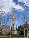 | |||
| 2, Corvisel Road, Prospect House | 54°57′18″N 4°29′10″W | Category C(S) | 38665 | | |||
| 23 King Street, Former Brewery House | 54°57′47″N 4°29′06″W | Category B | 38670 | | |||
| 12 Victoria Street | 54°57′28″N 4°28′58″W | Category C(S) | 38690 | | |||
| 40-44 (Even Nos) Victoria Street, The Royal Bank Of Scotland | 54°57′32″N 4°29′00″W | Category B | 38696 | | |||
| Victoria Street, Monument To 9Th Earl Of Galloway | 54°57′35″N 4°28′59″W | Category B | 38700 | | |||
| Windsor Road, Roman Catholic Church Of Our Lady And St Ninian And Churchyard | 54°57′42″N 4°29′11″W | Category B | 38701 | | |||
| 7 Church Street | 54°57′25″N 4°29′03″W | Category C(S) | 38660 | | |||
| 2 Queen Street, Dashwood House | 54°57′21″N 4°29′00″W | Category B | 38680 | | |||
| Queen Street, Black Horse Hotel With Coach House | 54°57′15″N 4°28′57″W | Category C(S) | 38681 | | |||
| 24-26A (Even Nos) Victoria Street | 54°57′30″N 4°28′59″W | Category C(S) | 38692 | | |||
| 32 King Street | 54°57′47″N 4°29′07″W | Category C(S) | 49412 | | |||
| 13 Church Street | 54°57′27″N 4°29′04″W | Category C(S) | 38661 | | |||
| King Street, Little Corsbie | 54°57′54″N 4°29′13″W | Category B | 38674 | | |||
| 20-22 (Even Nos) Victoria Street | 54°57′29″N 4°28′59″W | Category C(S) | 38691 | | |||
| 70-74 (Even Nos) Victoria Street | 54°57′34″N 4°29′01″W | Category C(S) | 38698 | |
Key
The scheme for classifying buildings in Scotland is:
- Category A: "buildings of national or international importance, either architectural or historic; or fine, little-altered examples of some particular period, style or building type."[1]
- Category B: "buildings of regional or more than local importance; or major examples of some particular period, style or building type, which may have been altered."[1]
- Category C: "buildings of local importance; lesser examples of any period, style, or building type, as originally constructed or moderately altered; and simple traditional buildings which group well with other listed buildings."[1]
In March 2016 there were 47,288 listed buildings in Scotland. Of these, 8% were Category A, and 50% were Category B, with the remaining 42% being Category C.[2]
Notes
- Sometimes known as OSGB36, the grid reference (where provided) is based on the British national grid reference system used by the Ordnance Survey.
• "Guide to National Grid". Ordnance Survey. Retrieved 12 December 2007.
• "Get-a-map". Ordnance Survey. Retrieved 17 December 2007. - Historic Environment Scotland assign a unique alphanumeric identifier to each designated site in Scotland, for listed buildings this always begins with "LB", for example "LB12345".
gollark: It would probably have been sensible to actually put any effort whatsoever into making a submission which wasn't obviously mine.
gollark: Well, at least I was joint second on guess accuracy.
gollark: How did *nobody else* guess Olivia?
gollark: Interesting.
gollark: !cg stop
References
- All entries, addresses and coordinates are based on data from Historic Scotland. This data falls under the Open Government Licence
- "What is Listing?". Historic Environment Scotland. Retrieved 29 May 2018.
- Scotland's Historic Environment Audit 2016 (PDF). Historic Environment Scotland and the Built Environment Forum Scotland. pp. 15–16. Retrieved 29 May 2018.
This article is issued from Wikipedia. The text is licensed under Creative Commons - Attribution - Sharealike. Additional terms may apply for the media files.