List of listed buildings in Sanquhar, Dumfries and Galloway
This is a list of listed buildings in the civil parish of Sanquhar in Dumfries and Galloway, Scotland.
List
| Name | Location | Date Listed | Grid Ref. [note 1] | Geo-coordinates | Notes | LB Number [note 2] | Image |
|---|---|---|---|---|---|---|---|
| High Street, Tolbooth/Town House | 55°22′05″N 3°55′30″W | Category A | 40540 | 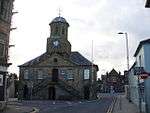 | |||
| 5, 7 High Street, Including Mary Millar's Shop | 55°22′05″N 3°55′29″W | Category C(S) | 40542 |  | |||
| 39, 41 High Street, Post Office And House | 55°22′04″N 3°55′24″W | Category B | 40547 | | |||
| 14-24 High Street (Even Nos) | 55°22′04″N 3°55′28″W | Category C(S) | 40553 | | |||
| 104-106 High Street, Library And House | 55°22′00″N 3°55′17″W | Category C(S) | 40560 | | |||
| Laurie's Wynd, Crichton Schoolhouse | 55°22′06″N 3°55′18″W | Category B | 40562 | | |||
| Sanquar House (Parish Manse) And Walled Garden | 55°22′14″N 3°56′02″W | Category B | 40565 | | |||
| Former Station, Stationmaster's House | 55°22′14″N 3°55′29″W | Category C(S) | 40566 | | |||
| Wanlockhead Village 1-18 (Numbers Inclusive) Fraser Terrace | 55°23′47″N 3°46′45″W | Category B | 17191 | | |||
| Wanlockhead Village 1-4 Mitchell Place (Numbers Inclusive) | 55°23′49″N 3°46′56″W | Category B | 17194 | | |||
| Wanlockhead Village School | 55°23′51″N 3°46′47″W | Category C(S) | 17195 | | |||
| Wanlockhead Village Straight Steps (Cottages At Beam Engine) | 55°23′58″N 3°47′08″W | Category C(S) | 17197 | | |||
| Blackaddie Bridge (Over River Nith) | 55°21′57″N 3°56′04″W | Category B | 40536 | | |||
| 100-102 High Street, Council Offices | 55°22′00″N 3°55′18″W | Category C(S) | 40559 | | |||
| Wanlockhead Village Burnside | 55°23′50″N 3°46′54″W | Category C(S) | 17189 | | |||
| Wanlockhead Village Former Wanlock Manse | 55°23′52″N 3°46′50″W | Category C(S) | 17230 | | |||
| Back Burn Road Bridge (Over Back Burn) | 55°21′03″N 3°54′03″W | Category C(S) | 17251 | | |||
| Eliock House Bridge (Main Driveway Over Garral Burn) | 55°20′45″N 3°53′51″W | Category C(S) | 17257 | | |||
| 31,33 High Street | 55°22′05″N 3°55′25″W | Category C(S) | 40545 | | |||
| High Street, St Ninians Church, Hall, Gatepiers And Screen Wall | 55°21′58″N 3°55′10″W | Category B | 40551 | | |||
| Wanlockhead Village Meadow Foot Burial Enclosure | 55°24′11″N 3°47′40″W | Category C(S) | 17193 | | |||
| Craigdarroch Farmhouse | 55°20′32″N 3°53′11″W | Category C(S) | 17253 | | |||
| Crawick Viaduct | 55°22′39″N 3°55′56″W | Category B | 17254 | | |||
| Euchan Bridge (Over Euchan Water) | 55°21′38″N 3°55′55″W | Category C(S) | 17258 | | |||
| Kello Bridge (Over Kello Water At Old Kelloside) | 55°22′34″N 3°59′31″W | Category B | 17259 | | |||
| Wanlockhead Village, Belton House | 55°23′57″N 3°46′32″W | Category C(S) | 17261 | | |||
| 63 High Street, Bank Of Scotland | 55°22′03″N 3°55′21″W | Category B | 40548 | | |||
| 71, 73 High Street | 55°22′02″N 3°55′18″W | Category B | 40549 | | |||
| 36 And 40 High Street | 55°22′03″N 3°55′26″W | Category C(S) | 40556 | | |||
| Saint Mary Street, Evangelical Union Church | 55°22′09″N 3°55′26″W | Category C(S) | 40564 | | |||
| Wanlockhead Village Stewart Place | 55°23′54″N 3°47′00″W | Category B | 17196 | | |||
| Church Road, Sanquhar Parish Church, (St Bride`S) And Churchyard Including Hamilton Monument | 55°22′13″N 3°55′41″W | Category B | 40538 | | |||
| Crawick Bridge, (A76 Over Crawick Water) | 55°22′30″N 3°56′10″W | Category B | 40539 | | |||
| High Street, Monument | 55°22′01″N 3°55′16″W | Category C(S) | 40550 | | |||
| Mennock Viaduct | 55°21′08″N 3°52′49″W | Category B | 17260 | | |||
| 1, 3 High Street, Nithsdale Hotel | 55°22′06″N 3°55′30″W | Category C(S) | 40541 | | |||
| 27, 29 High Street | 55°22′05″N 3°55′26″W | Category C(S) | 40544 | | |||
| 35, 37 High Street | 55°22′04″N 3°55′25″W | Category C(S) | 40546 | | |||
| 74, 76 High Street | 55°22′01″N 3°55′20″W | Category B | 40557 | | |||
| Laurie's Wynd, Former Crichton School | 55°22′06″N 3°55′18″W | Category B | 40561 | | |||
| Wanlockhead Village Church (Church Of Scotland) | 55°23′56″N 3°47′05″W | Category C(S) | 17190 | | |||
| Wanlockhead Village Library | 55°23′52″N 3°46′47″W | Category A | 17192 | 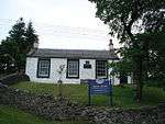 | |||
| Eliock House | 55°20′47″N 3°53′56″W | Category B | 17256 | | |||
| 78-86 High Street (Even Numbers) | 55°22′01″N 3°55′19″W | Category B | 40558 | | |||
| Wanlockhead Village Wanlock House | 55°23′55″N 3°46′38″W | Category C(S) | 17229 | | |||
| Eliock Bridge | 55°21′14″N 3°53′17″W | Category B | 17255 | | |||
| 2 Church Road | 55°22′06″N 3°55′31″W | Category B | 40537 | | |||
| 11, 13 High Street | 55°22′05″N 3°55′29″W | Category C(S) | 40543 | | |||
| High Street, St Ninian's Manse | 55°21′58″N 3°55′10″W | Category C(S) | 40552 | | |||
| 26 High Street, Royal Bank Of Scotland | 55°22′03″N 3°55′27″W | Category B | 40554 | | |||
| 28-34 High Street | 55°22′03″N 3°55′27″W | Category C(S) | 40555 | | |||
| Queensberry Square, School (Range To North East) | 55°22′11″N 3°55′39″W | Category B | 40563 | |
Key
The scheme for classifying buildings in Scotland is:
- Category A: "buildings of national or international importance, either architectural or historic; or fine, little-altered examples of some particular period, style or building type."[1]
- Category B: "buildings of regional or more than local importance; or major examples of some particular period, style or building type, which may have been altered."[1]
- Category C: "buildings of local importance; lesser examples of any period, style, or building type, as originally constructed or moderately altered; and simple traditional buildings which group well with other listed buildings."[1]
In March 2016 there were 47,288 listed buildings in Scotland. Of these, 8% were Category A, and 50% were Category B, with the remaining 42% being Category C.[2]
Notes
- Sometimes known as OSGB36, the grid reference (where provided) is based on the British national grid reference system used by the Ordnance Survey.
• "Guide to National Grid". Ordnance Survey. Retrieved 12 December 2007.
• "Get-a-map". Ordnance Survey. Retrieved 17 December 2007. - Historic Environment Scotland assign a unique alphanumeric identifier to each designated site in Scotland, for listed buildings this always begins with "LB", for example "LB12345".
gollark: <@388340852549877761> Please return those buckets.
gollark: modifiers.
gollark: Or, if you want more modifiers, cobalt/sponge/manyullyn with paper embossed.
gollark: I would recommend, though, cobalt head, knightslime head embossed, sponge binding, manyullyn tool rod.
gollark: <@115156616256552962> Do you have any?
References
- All entries, addresses and coordinates are based on data from Historic Scotland. This data falls under the Open Government Licence
- "What is Listing?". Historic Environment Scotland. Retrieved 29 May 2018.
- Scotland's Historic Environment Audit 2016 (PDF). Historic Environment Scotland and the Built Environment Forum Scotland. pp. 15–16. Retrieved 29 May 2018.
This article is issued from Wikipedia. The text is licensed under Creative Commons - Attribution - Sharealike. Additional terms may apply for the media files.