List of listed buildings in Kirkcudbright, Dumfries and Galloway
This is a list of listed buildings in the parish of Kirkcudbright in Dumfries and Galloway, Scotland.
List
| Name | Location | Date Listed | Grid Ref. [note 1] | Geo-coordinates | Notes | LB Number [note 2] | Image |
|---|---|---|---|---|---|---|---|
| 15 And 17 Millburn Street | 54°50′17″N 4°02′46″W | Category C(S) | 36565 |  | |||
| 9 St Cuthbert's Street | 54°50′13″N 4°03′00″W | Category C(S) | 36571 | | |||
| 38 St Cuthbert's Street | 54°50′12″N 4°03′02″W | Category C(S) | 36590 | | |||
| 15 St Mary's Place, Townend | 54°50′05″N 4°03′03″W | Category C(S) | 36595 | | |||
| 21, 23 And 25 St Mary's Place, Townend | 54°50′05″N 4°03′02″W | Category C(S) | 36598 | | |||
| 35 And 37 St Mary's Street, Royal Bank Of Scotland And Royal Hotel | 54°50′12″N 4°02′56″W | Category C(S) | 36611 | | |||
| 9 Union Street | 54°50′10″N 4°03′14″W | Category C(S) | 36630 | | |||
| 23 Union Street | 54°50′10″N 4°03′16″W | Category C(S) | 36634 | | |||
| 4 Union Street | 54°50′10″N 4°03′12″W | Category C(S) | 36637 | | |||
| Castle Street, Maclellan's Castle | 54°50′13″N 4°03′11″W | Category A | 36484 | 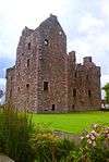 | |||
| 14 Castle Street | 54°50′11″N 4°03′11″W | Category C(S) | 36489 | | |||
| 22 Castle Street | 54°50′10″N 4°03′12″W | Category B | 36491 | | |||
| 13 And 15 Church Place | 54°50′08″N 4°02′57″W | Category C(S) | 36500 | | |||
| 3, 5 High Street And Gazebo | 54°50′13″N 4°03′14″W | Category B | 36502 | | |||
| 7, 9 High Street | 54°50′12″N 4°03′13″W | Category B | 36503 | 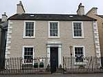 | |||
| 17, 19 And 21 High Street | 54°50′12″N 4°03′14″W | Category B | 36505 | 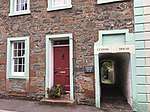 | |||
| 27 And 29 High Street | 54°50′11″N 4°03′16″W | Category B | 36507 | | |||
| 39, 41 And 43 High Street | 54°50′10″N 4°03′17″W | Category C(S) | 36510 | | |||
| 81 High Street | 54°50′08″N 4°03′18″W | Category C(S) | 36516 | | |||
| 109 And 111 High Street | 54°50′06″N 4°03′11″W | Category C(S) | 36521 | | |||
| 8 High Street, Blair House And Summer House And Walls To Castle Dykes | 54°50′13″N 4°03′16″W | Category A | 36529 | 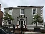 | |||
| 54 And 56 High Street, The Rectory | 54°50′08″N 4°03′21″W | Category B | 36541 | | |||
| High Street, Tolbooth, Market Cross And Well | 54°50′08″N 4°03′20″W | Category A | 36542 | 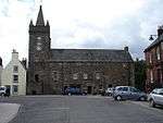 | |||
| 64 High Street (Milroys House) And The Cottage, Steeple Close, 64A High Street | 54°50′07″N 4°03′20″W | Category B | 36544 | | |||
| 74 High Street And Cannon's Close | 54°50′07″N 4°03′19″W | Category A | 36546 | | |||
| 76-82 (Even) High Street (82 In Police Close) | 54°50′06″N 4°03′18″W | Category B | 36547 | | |||
| 110 High Street | 54°50′06″N 4°03′13″W | Category B | 36554 | | |||
| 140 High Street | 54°50′05″N 4°03′09″W | Category C(S) | 36560 | | |||
| Castlebank, Harbour Cottage Gallery | 54°50′15″N 4°03′10″W | Category B | 36456 |  | |||
| 1 And 3 Castle Street | 54°50′12″N 4°03′08″W | Category C(S) | 36461 | | |||
| 34 St Cuthbert's Street | 54°50′12″N 4°03′03″W | Category C(S) | 36588 | | |||
| St Mary's Street, Town Hall | 54°50′10″N 4°03′00″W | Category B | 36604 | 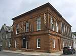 | |||
| 49 St Mary's Street | 54°50′14″N 4°02′54″W | Category C(S) | 36613 | | |||
| St Mary's Street, St Mary's Church | 54°50′16″N 4°02′50″W | Category B | 36616 | 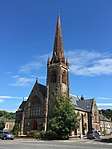 | |||
| St Mary's Street, Selkirk Memorial | 54°50′13″N 4°02′58″W | Category C(S) | 36622 | | |||
| 34, 36, 38 And 40 St Mary's Street | 54°50′15″N 4°02′55″W | Category C(S) | 36624 | | |||
| St Mary's Wynd And 60 High Street, Anchorage | 54°50′08″N 4°03′21″W | Category B | 36625 | | |||
| 27 Castle Street | 54°50′09″N 4°03′11″W | Category C(S) | 36471 | | |||
| 39 Castle Street | 54°50′08″N 4°03′12″W | Category B | 36477 | | |||
| 32 Castle Street | 54°50′09″N 4°03′12″W | Category C(S) | 36494 | | |||
| 15A High Street And 1 Gordon Place | 54°50′12″N 4°03′14″W | Category C(S) | 36504 | | |||
| 23 And 25 High Street | 54°50′12″N 4°03′16″W | Category B | 36506 | | |||
| High Street, Selkirk Arms Hotel And Close And 127 High Street | 54°50′05″N 4°03′07″W | Category B | 36524 |  | |||
| 66 (Wynd End) W. Side Of Close, 68 E. Side Of Close And 70 High Street | 54°50′07″N 4°03′20″W | Category A | 36545 | | |||
| 138 High Street | 54°50′05″N 4°03′09″W | Category C(S) | 36559 | | |||
| Castlebank, The Old Studio | 54°50′13″N 4°03′13″W | Category C(S) | 36454 | | |||
| 1-9 (Odd Nos) Castle Gardens | 54°50′12″N 4°03′11″W | Category B | 36458 | | |||
| 5 Castle Street | 54°50′12″N 4°03′09″W | Category C(S) | 36462 | | |||
| Galloway Hydroelectric Power Scheme, Tongland Dam | 54°52′09″N 4°01′28″W | Category B | 51698 | | |||
| 8 St Cuthbert's Street | 54°50′12″N 4°03′07″W | Category C(S) | 36581 | | |||
| 14 St Cuthbert's Street | 54°50′12″N 4°03′06″W | Category C(S) | 36583 | | |||
| 20 And 22 St Cuthbert's Street | 54°50′12″N 4°03′05″W | Category C(S) | 36585 | | |||
| 10 St Mary's Place, Saddler's Croft | 54°50′04″N 4°03′04″W | Category B | 36602 | | |||
| 23 And 25 St Mary's Street | 54°50′11″N 4°02′57″W | Category B | 36608 | | |||
| 51 St Mary's Street | 54°50′14″N 4°02′54″W | Category C(S) | 36614 | | |||
| St Mary's Street, Kirkcudbright Parish Church | 54°50′11″N 4°03′03″W | Category B | 36621 |  | |||
| 30 And 32 St Mary's Street | 54°50′15″N 4°02′55″W | Category B | 36623 | | |||
| St Mary's Wynd, Kirkcudbright Academy And Cochran Memorial Gymnasium | 54°50′06″N 4°03′25″W | Category C(S) | 36626 | | |||
| 1 Union Street | 54°50′09″N 4°03′12″W | Category C(S) | 36627 | | |||
| 15, 17 And 19 Union Street | 54°50′10″N 4°03′15″W | Category C(S) | 36632 | | |||
| 14 And 16 Union Street | 54°50′10″N 4°03′14″W | Category B | 36640 | | |||
| 35 Castle Street | 54°50′08″N 4°03′11″W | Category C(S) | 36475 | | |||
| 55 Castle Street (Through Cobbled Pend) | 54°50′06″N 4°03′12″W | Category C(S) | 36482 | | |||
| Castle Street, War Memorial, 1st And 2nd World Wars | 54°50′13″N 4°03′09″W | Category C(S) | 36485 | | |||
| 16 Castle Street, Castle Guest House | 54°50′11″N 4°03′11″W | Category B | 36490 | | |||
| 28, 30 Castle Street | 54°50′09″N 4°03′12″W | Category C(S) | 36493 | | |||
| 46, 48 Castle Street | 54°50′08″N 4°03′13″W | Category C(S) | 36496 | | |||
| 3, 5, 7 And 9 Church Place | 54°50′09″N 4°02′59″W | Category C(S) | 36498 | | |||
| 1 High Street | 54°50′14″N 4°03′14″W | Category B | 36501 | | |||
| 33 High Street | 54°50′11″N 4°03′17″W | Category C(S) | 36508 | | |||
| 77 High Street | 54°50′08″N 4°03′18″W | Category C(S) | 36515 | | |||
| 105 High Street | 54°50′06″N 4°03′12″W | Category B | 36520 | | |||
| High Street, Cannonwalls | 54°50′06″N 4°03′10″W | Category B | 36522 | | |||
| 2 High Street, Moatwell | 54°50′15″N 4°03′14″W | Category B | 36526 | | |||
| 4 High Street | 54°50′14″N 4°03′14″W | Category B | 36527 | | |||
| 16 High Street | 54°50′12″N 4°03′17″W | Category B | 36533 | | |||
| 18 High Street | 54°50′11″N 4°03′17″W | Category B | 36534 | | |||
| 46 High Street, Greengate House | 54°50′09″N 4°03′20″W | Category B | 36538 |  | |||
| 62 High Street, Tolbooth Gallery And Steeple Close | 54°50′07″N 4°03′20″W | Category B | 36543 | | |||
| 94 High Street | 54°50′06″N 4°03′16″W | Category B | 36549 | | |||
| 100A, B And C High Street | 54°50′06″N 4°03′15″W | Category C(S) | 36551 | | |||
| 106 And 108 High Street | 54°50′06″N 4°03′15″W | Category B | 36553 | | |||
| High Street, Tolbooth, Market Cross And Well | 54°50′14″N 4°03′13″W | Category B | 36453 |  | |||
| Millburn Street, Former Cornmill | 54°50′19″N 4°02′44″W | Category B | 36563 | | |||
| 19 Millburn Street | 54°50′17″N 4°02′46″W | Category C(S) | 36566 | | |||
| 17 And 19 St Cuthbert's Street | 54°50′13″N 4°02′59″W | Category C(S) | 36574 | | |||
| St Cuthbert's Street, The Commercial Hotel | 54°50′13″N 4°02′57″W | Category C(S) | 36577 | | |||
| 4 And 6 St Cuthbert's Street | 54°50′13″N 4°03′08″W | Category C(S) | 36580 | | |||
| 1 St Mary's Place | 54°50′05″N 4°03′06″W | Category C(S) | 36594 | | |||
| 9, 11 And 13 St Mary's Street | 54°50′10″N 4°02′59″W | Category B | 36605 | | |||
| 19 And 21 St Mary's Street | 54°50′11″N 4°02′58″W | Category B | 36607 | | |||
| 53, 55 And 57 St Mary's Street | 54°50′14″N 4°02′53″W | Category C(S) | 36615 | | |||
| St Mary's Street, Johnston's Free School | 54°50′18″N 4°02′48″W | Category B | 36617 |  | |||
| 7 Union Street | 54°50′10″N 4°03′13″W | Category C(S) | 36629 | | |||
| 26 Union Street | 54°50′11″N 4°03′16″W | Category C(S) | 36643 | | |||
| 37 Castle Street | 54°50′08″N 4°03′12″W | Category B | 36476 | | |||
| 49, 51 Castle Street | 54°50′07″N 4°03′12″W | Category B | 36480 | | |||
| 12 Castle Street | 54°50′12″N 4°03′10″W | Category C(S) | 36488 | | |||
| 37 High Street | 54°50′10″N 4°03′17″W | Category C(S) | 36509 | | |||
| 45 And 45A High Street | 54°50′10″N 4°03′18″W | Category C(S) | 36511 | | |||
| 67A And 67B High Street | 54°50′08″N 4°03′19″W | Category C(S) | 36514 | | |||
| 83 High Street | 54°50′08″N 4°03′17″W | Category C(S) | 36517 | | |||
| High Street, Stewartry District Council Offices | 54°50′06″N 4°03′09″W | Category B | 36523 |  | |||
| 12 High Street, With 10 High Street, Broughton House And Walls To Castle Dykes | 54°50′13″N 4°03′16″W | Category A | 36530 |  | |||
| 96 And 98 High Street | 54°50′06″N 4°03′16″W | Category B | 36550 | | |||
| 104 High Street | 54°50′06″N 4°03′15″W | Category B | 36552 | | |||
| 1 Castle Street And 2 St Cuthbert's Close | 54°50′12″N 4°03′08″W | Category C(S) | 36460 | | |||
| 15 Castle Street | 54°50′11″N 4°03′09″W | Category C(S) | 36465 | | |||
| 21 St Cuthbert's Street | 54°50′13″N 4°02′59″W | Category C(S) | 36575 | | |||
| 28 And 30 St Cuthbert's Street | 54°50′12″N 4°03′04″W | Category C(S) | 36586 | | |||
| 40 And 40A St Cuthbert's Street | 54°50′12″N 4°03′01″W | Category C(S) | 36591 | | |||
| 50 St Cuthbert's Street | 54°50′12″N 4°02′53″W | Category C(S) | 36593 | | |||
| 17 St Mary's Place, Townend | 54°50′05″N 4°03′03″W | Category C(S) | 36596 | | |||
| 4 St Mary's Place | 54°50′04″N 4°03′05″W | Category C(S) | 36601 | | |||
| St Mary's Street, Church Hall | 54°50′08″N 4°03′02″W | Category C(S) | 36603 | | |||
| 27 St Mary's Street | 54°50′12″N 4°02′57″W | Category B | 36609 | | |||
| St Mary's Street, Atkinson's Place | 54°50′21″N 4°02′47″W | Category C(S) | 36618 | | |||
| 3 Union Street | 54°50′09″N 4°03′13″W | Category C(S) | 36628 | | |||
| 11 And 13 Union Street | 54°50′10″N 4°03′14″W | Category C(S) | 36631 | | |||
| 20 And 22 Union Street | 54°50′10″N 4°03′15″W | Category C(S) | 36641 | | |||
| 21 Castle Street | 54°50′10″N 4°03′10″W | Category B | 36468 | | |||
| 25 Castle Street | 54°50′10″N 4°03′10″W | Category C(S) | 36470 | | |||
| 29 Castle Street | 54°50′09″N 4°03′11″W | Category C(S) | 36472 | | |||
| 33 Castle Street | 54°50′09″N 4°03′11″W | Category C(S) | 36474 | | |||
| 53 Castle Street | 54°50′07″N 4°03′13″W | Category B | 36481 | | |||
| 57, 59 Castle Street | 54°50′06″N 4°03′13″W | Category C(S) | 36483 | | |||
| 6, 8 Castle Street | 54°50′12″N 4°03′10″W | Category C(S) | 36487 | | |||
| 11 Church Place | 54°50′09″N 4°02′58″W | Category C(S) | 36499 | | |||
| 57, 59 And 61 High Street | 54°50′09″N 4°03′19″W | Category C(S) | 36512 | | |||
| 44 High Street, Greengate Close | 54°50′10″N 4°03′21″W | Category B | 36537 | | |||
| 122 High Street | 54°50′06″N 4°03′11″W | Category C(S) | 36557 | | |||
| Castlebank, Shorehouse | 54°50′15″N 4°03′11″W | Category C(S) | 36457 | | |||
| Castle Mains | 54°50′07″N 4°03′33″W | Category C(S) | 36459 | | |||
| 9 And 11 Castle Street | 54°50′11″N 4°03′09″W | Category B | 36464 | | |||
| Kirkcudbright Bridge | 54°50′20″N 4°03′01″W | Category B | 9712 | 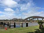 | |||
| St Cuthbert's Churchyard (Formerly Old Kirkyard), Including Boundary Wall | 54°50′16″N 4°02′24″W | Category B | 36567 | | |||
| 1 And 2 St Cuthbert's Place, The Steam Packet Inn | 54°50′14″N 4°03′01″W | Category C(S) | 36569 | | |||
| 27 St Cuthbert's Street | 54°50′13″N 4°02′57″W | Category C(S) | 36578 | | |||
| 36 St Cuthbert's Street | 54°50′12″N 4°03′02″W | Category C(S) | 36589 | | |||
| 15 And 17 St Mary's Street, Bank Of Scotland and Manager's House | 54°50′11″N 4°02′58″W | Category B | 36606 | | |||
| 29 And 31 St Mary's Street | 54°50′12″N 4°02′57″W | Category B | 36610 | | |||
| St Mary's Street, Museum | 54°50′07″N 4°03′06″W | Category C(S) | 36620 | | |||
| 2 Union Street | 54°50′10″N 4°03′12″W | Category B | 36636 | | |||
| 24 Union Street | 54°50′11″N 4°03′16″W | Category C(S) | 36642 | | |||
| 2 Castle Street | 54°50′12″N 4°03′10″W | Category B | 36486 | | |||
| 34, 34A And 36 Castle Street | 54°50′09″N 4°03′13″W | Category C(S) | 36495 | | |||
| 50, 52 Castle Street | 54°50′08″N 4°03′13″W | Category C(S) | 36497 | | |||
| High Street, Sheriff Court House And Public Library | 54°50′07″N 4°03′16″W | Category C(S) | 36518 | | |||
| 103 High Street | 54°50′06″N 4°03′12″W | Category C(S) | 36519 | | |||
| 34 High Street | 54°50′10″N 4°03′18″W | Category C(S) | 36535 | | |||
| 52 High Street | 54°50′09″N 4°03′21″W | Category C(S) | 36540 | | |||
| 118 High Street | 54°50′06″N 4°03′12″W | Category B | 36556 | | |||
| 142 High Street | 54°50′05″N 4°03′09″W | Category C(S) | 36561 | | |||
| Castlebank, Harbour Cottage | 54°50′15″N 4°03′11″W | Category C(S) | 36455 | | |||
| Ellenbank | 54°50′59″N 4°02′22″W | Category B | 9711 | | |||
| Cannee Farm Steading | 54°49′41″N 4°02′42″W | Category B | 9713 | | |||
| St Cuthbert's Street, Greyfriars Church (Episcopal Church) | 54°50′14″N 4°03′09″W | Category B | 36568 | | |||
| 11 And 13 St Cuthbert's Street | 54°50′13″N 4°03′00″W | Category C(S) | 36572 | | |||
| 15 St Cuthbert's Street | 54°50′13″N 4°02′59″W | Category C(S) | 36573 | | |||
| 2 St Cuthbert's Street | 54°50′13″N 4°03′08″W | Category C(S) | 36579 | | |||
| St Cuthbert's Street Well | 54°50′13″N 4°03′00″W | Category C(S) | 36592 | | |||
| 2 St Mary's Place | 54°50′04″N 4°03′05″W | Category B | 36600 | | |||
| 47 St Mary's Street | 54°50′14″N 4°02′54″W | Category C(S) | 36612 | | |||
| 10 And 12 Union Street | 54°50′10″N 4°03′13″W | Category B | 36639 | | |||
| 30 Union Street | 54°50′11″N 4°03′16″W | Category C(S) | 36644 | | |||
| Castle Street, Masonic Arms | 54°50′10″N 4°03′10″W | Category B | 36467 | | |||
| 23 Castle Street | 54°50′10″N 4°03′10″W | Category B | 36469 | | |||
| 24, 26 Castle Street | 54°50′09″N 4°03′12″W | Category C(S) | 36492 | | |||
| 63 High Street | 54°50′08″N 4°03′19″W | Category C(S) | 36513 | | |||
| 129 High Street | 54°50′05″N 4°03′07″W | Category C(S) | 36525 | | |||
| 14 And 14A High Street | 54°50′12″N 4°03′17″W | Category B | 36532 | | |||
| 84 High Street | 54°50′06″N 4°03′17″W | Category B | 36548 |  | |||
| 116 High Street, Gordon House Hotel | 54°50′06″N 4°03′13″W | Category C(S) | 36555 | | |||
| 134 And 136 High Street | 54°50′05″N 4°03′10″W | Category C(S) | 36558 | | |||
| 9 Millburn Street | 54°50′18″N 4°02′45″W | Category C(S) | 36564 | | |||
| 3 And 3A St Cuthbert's Street | 54°50′13″N 4°03′01″W | Category C(S) | 36570 | | |||
| 23 St Cuthbert's Street | 54°50′13″N 4°02′58″W | Category C(S) | 36576 | | |||
| 10 And 12 St Cuthbert's Street | 54°50′13″N 4°03′07″W | Category C(S) | 36582 | | |||
| 16 And 18 St Cuthbert's Street, Solway Tide | 54°50′12″N 4°03′06″W | Category C(S) | 36584 | | |||
| 32 And 32A St Cuthbert's Street | 54°50′12″N 4°03′03″W | Category C(S) | 36587 | | |||
| 19 St Mary's Place, Townend | 54°50′02″N 4°03′02″W | Category C(S) | 36597 | | |||
| 31 St Mary's Place, Townend | 54°50′06″N 4°03′01″W | Category C(S) | 36599 | | |||
| St Mary's Street. Oakley And Wester Oakley | 54°50′02″N 4°03′09″W | Category B | 36619 | | |||
| 21 Union Street | 54°50′10″N 4°03′15″W | Category C(S) | 36633 | | |||
| 25 Union Street | 54°50′10″N 4°03′16″W | Category C(S) | 36635 | | |||
| 6 And 8 Union Street | 54°50′10″N 4°03′13″W | Category C(S) | 36638 | | |||
| 31 Castle Street | 54°50′09″N 4°03′11″W | Category B | 36473 | | |||
| 41, 43 Castle Street | 54°50′07″N 4°03′12″W | Category B | 36478 | | |||
| 47 Castle Street | 54°50′07″N 4°03′12″W | Category C(S) | 36479 | | |||
| 6 High Street | 54°50′14″N 4°03′15″W | Category C(S) | 36528 | | |||
| 36 High Street | 54°50′10″N 4°03′19″W | Category B | 36536 | | |||
| 48 And 48A High Street | 54°50′09″N 4°03′20″W | Category B | 36539 | | |||
| Millburn Street, Millburn House | 54°50′20″N 4°02′45″W | Category C(S) | 36562 | | |||
| 7 Castle Street | 54°50′12″N 4°03′09″W | Category B | 36463 | | |||
| 17 Castle Street | 54°50′11″N 4°03′09″W | Category C(S) | 36466 | |
Key
The scheme for classifying buildings in Scotland is:
- Category A: "buildings of national or international importance, either architectural or historic; or fine, little-altered examples of some particular period, style or building type."[1]
- Category B: "buildings of regional or more than local importance; or major examples of some particular period, style or building type, which may have been altered."[1]
- Category C: "buildings of local importance; lesser examples of any period, style, or building type, as originally constructed or moderately altered; and simple traditional buildings which group well with other listed buildings."[1]
In March 2016 there were 47,288 listed buildings in Scotland. Of these, 8% were Category A, and 50% were Category B, with the remaining 42% being Category C.[2]
Notes
- Sometimes known as OSGB36, the grid reference (where provided) is based on the British national grid reference system used by the Ordnance Survey.
• "Guide to National Grid". Ordnance Survey. Retrieved 12 December 2007.
• "Get-a-map". Ordnance Survey. Retrieved 17 December 2007. - Historic Environment Scotland assign a unique alphanumeric identifier to each designated site in Scotland, for listed buildings this always begins with "LB", for example "LB12345".
gollark: j (integer)
gollark: Okay, maybe not.
gollark: I have entered the final phase.
gollark: This actually says a lot, possibly maybe.
gollark: So you can go through arbitrarily many trivially.
References
- All entries, addresses and coordinates are based on data from Historic Scotland. This data falls under the Open Government Licence
- "What is Listing?". Historic Environment Scotland. Retrieved 29 May 2018.
- Scotland's Historic Environment Audit 2016 (PDF). Historic Environment Scotland and the Built Environment Forum Scotland. pp. 15–16. Retrieved 29 May 2018.
This article is issued from Wikipedia. The text is licensed under Creative Commons - Attribution - Sharealike. Additional terms may apply for the media files.