List of listed buildings in Gatehouse Of Fleet, Dumfries and Galloway
This is a list of listed buildings in the parish of Gatehouse Of Fleet in Dumfries and Galloway, Scotland.
List
| Name | Location | Date Listed | Grid Ref. [note 1] | Geo-coordinates | Notes | LB Number [note 2] | Image |
|---|---|---|---|---|---|---|---|
| 1 Ann Street | 54°52′59″N 4°10′53″W | Category C(S) | 32021 |  | |||
| Ann Street. Roseville, Railings And Outbuildings | 54°52′58″N 4°10′48″W | Category B | 32029 | | |||
| 3-23 Birtwhistle Street | 54°53′05″N 4°11′01″W | Category B | 32033 | | |||
| 5 Boat Green | 54°52′48″N 4°11′12″W | Category C(S) | 32035 | | |||
| 29 Fleet Street | 54°52′50″N 4°11′19″W | Category B | 32051 | | |||
| 6-8 (Even Nos) Fleet Street | 54°52′50″N 4°11′15″W | Category B | 32056 | | |||
| 16 Fleet Street | 54°52′49″N 4°11′16″W | Category B | 32059 | | |||
| 28-30 (Even Nos) Fleet Street | 54°52′49″N 4°11′18″W | Category B | 32064 | | |||
| 49-51 (Odd Nos) High Street | 54°52′56″N 4°11′01″W | Category C(S) | 32075 | | |||
| 53-55 (Odd Nos) High Street | 54°52′56″N 4°11′01″W | Category C(S) | 32076 | | |||
| High Street, Bruachmor Brewery And Brewery Brae | 54°52′54″N 4°11′05″W | Category B | 32095 | | |||
| 5 Ann Street | 54°52′58″N 4°10′52″W | Category C(S) | 32022 | | |||
| 11 Ann Street, Cally Estate Office | 54°52′57″N 4°10′51″W | Category B | 32025 | | |||
| Ann Street, Cox`S Lodge With Boundary Walls And Gatepiers | 54°52′56″N 4°10′46″W | Category B | 32026 | | |||
| Ann Street, The Murray Arms And The Gatehouse | 54°52′59″N 4°10′51″W | Category B | 32027 | | |||
| Ann Street, Neilson Square | 54°52′58″N 4°10′47″W | Category B | 32030 | | |||
| Barlay Mill | 54°53′28″N 4°10′56″W | Category C(S) | 32032 | | |||
| 6-8 (Even Nos) Bridge Terrace | 54°52′50″N 4°11′13″W | Category B | 32040 | | |||
| 24-26 (Even Nos) Fleet Street | 54°52′49″N 4°11′18″W | Category B | 32063 | | |||
| 21 High Street | 54°52′58″N 4°10′57″W | Category B | 32072 | | |||
| 27-29 (Odd Nos) High Street | 54°52′58″N 4°10′58″W | Category C(S) | 32073 | | |||
| 57 High Street | 54°52′56″N 4°11′02″W | Category B | 32077 | | |||
| 2-4 (Even Nos) High Street | 54°52′59″N 4°10′54″W | Category C(S) | 32078 | | |||
| 12-14 (Even Nos) High Street | 54°52′58″N 4°10′55″W | Category C(S) | 32081 | | |||
| 58-60 (Even Nos) High Street | 54°52′55″N 4°11′01″W | Category C(S) | 32090 | | |||
| 62 High Street | 54°52′55″N 4°11′02″W | Category B | 32091 | | |||
| 70 High Street, The Angel Hotel | 54°52′54″N 4°11′03″W | Category B | 32093 | | |||
| Ann Street, The Masonic Arms | 54°52′59″N 4°10′50″W | Category B | 32028 | | |||
| 3 Boat Green | 54°52′48″N 4°11′12″W | Category B | 32034 | | |||
| 4 Bridge Terrace | 54°52′51″N 4°11′13″W | Category B | 32039 | | |||
| Cally Main Gate Lodges, Gates And Gatepiers | 54°52′54″N 4°10′30″W | Category B | 32041 | 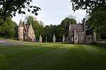 | |||
| 25 Fleet Street | 54°52′50″N 4°11′18″W | Category B | 32049 | | |||
| 27 Fleet Street | 54°52′50″N 4°11′18″W | Category B | 32050 | | |||
| 39-41 (Odd Nos) Fleet Street | 54°52′48″N 4°11′21″W | Category B | 32054 | | |||
| 34-36 (Even Nos) High Street | 54°52′57″N 4°10′57″W | Category B | 32085 | | |||
| 50-52 (Even Nos) High Street | 54°52′56″N 4°11′00″W | Category C(S) | 32088 | | |||
| High Street, Horatio Square | 54°53′00″N 4°10′54″W | Category B | 32097 | | |||
| 7 Ann Street | 54°52′58″N 4°10′52″W | Category C(S) | 32023 | | |||
| 9 Ann Street | 54°52′58″N 4°10′51″W | Category C(S) | 32024 | | |||
| Ann Street, Mill House, (Former Scott`S Cotton Mill) | 54°52′57″N 4°10′44″W | Category B | 32031 | | |||
| 7 Boat Green | 54°52′47″N 4°11′12″W | Category C(S) | 32036 | | |||
| The Bobbin Mill | 54°52′57″N 4°11′07″W | Category B | 32037 | 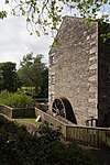 | |||
| Fleet Street, The Anwoth Hotel | 54°52′51″N 4°11′15″W | Category C(S) | 32047 | | |||
| 10-12 (Even Nos) Fleet Street | 54°52′50″N 4°11′15″W | Category B | 32057 | | |||
| 14 Fleet Street | 54°52′50″N 4°11′16″W | Category B | 32058 | | |||
| 3 Hannay Street | 54°52′50″N 4°11′14″W | Category C(S) | 32066 | | |||
| 11-15 (Odd Nos) High Street) | 54°52′59″N 4°10′56″W | Category B | 32070 | | |||
| 64-66 (Even Nos) High Street | 54°52′55″N 4°11′02″W | Category C(S) | 32092 | | |||
| High Street, Brae Cottage | 54°52′54″N 4°11′05″W | Category B | 32096 | | |||
| St Mary`S Episcopal Church With Railings | 54°52′52″N 4°11′14″W | Category C(S) | 32099 | | |||
| Cardonness Castle Cottage | 54°52′23″N 4°11′50″W | Category C(S) | 32043 | | |||
| 15 And 15A Fleet Street | 54°52′50″N 4°11′16″W | Category C(S) | 32048 | | |||
| 6 High Street | 54°52′59″N 4°10′54″W | Category C(S) | 32079 | | |||
| 18-20 (Even Nos) High Street | 54°52′58″N 4°10′56″W | Category B | 32082 | | |||
| 32 High Street | 54°52′57″N 4°10′57″W | Category C(S) | 32084 | | |||
| 38-40 (Even Nos) High Street | 54°52′57″N 4°10′58″W | Category B | 32086 | | |||
| 46-48 (Even Nos) High Street | 54°52′56″N 4°10′59″W | Category B | 32087 | | |||
| Church Street, Girthon Parish Church (C Of S) With Lamp Standards, Gatepiers, Gates And Retaining Walls | 54°53′02″N 4°10′53″W | Category B | 32044 | 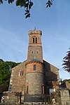 | |||
| 3 And 5 Digby Street | 54°52′58″N 4°10′59″W | Category B | 32045 | | |||
| 2-4 Fleet Street | 54°52′50″N 4°11′14″W | Category B | 32055 | | |||
| 18 Fleet Street | 54°52′49″N 4°11′17″W | Category B | 32060 | | |||
| 32 Fleet Street, Portville With Gates And Boundary Walls | 54°52′48″N 4°11′18″W | Category B | 32065 | | |||
| 3-5 (Odd Nos) High Street | 54°52′59″N 4°10′55″W | Category B | 32068 | | |||
| 7-9 (Odd Nos) High Street | 54°52′59″N 4°10′56″W | Category C(S) | 32069 | | |||
| 47 High Street, Bank Of Fleet Hotel | 54°52′57″N 4°11′00″W | Category B | 32074 | | |||
| Woodside Terrace, Toll House | 54°53′03″N 4°10′49″W | Category B | 32100 | | |||
| 2 Bridge Terrace | 54°52′51″N 4°11′12″W | Category B | 32038 | | |||
| Cardonness Castle | 54°52′20″N 4°11′53″W | Category A | 32042 | 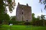 | |||
| Fleet Bridge | 54°52′52″N 4°11′11″W | Category C(S) | 32046 | | |||
| 33 Fleet Street | 54°52′49″N 4°11′20″W | Category B | 32052 | | |||
| 20 Fleet Street | 54°52′49″N 4°11′17″W | Category C(S) | 32061 | | |||
| 22 Fleet Street | 54°52′49″N 4°11′17″W | Category B | 32062 | | |||
| 8-10 (Even Nos) High Street | 54°52′59″N 4°10′55″W | Category B | 32080 | | |||
| 24-28 (Even Nos) High Street | 54°52′58″N 4°10′57″W | Category C(S) | 32083 | | |||
| 56 High Street | 54°52′55″N 4°11′01″W | Category B | 32089 | | |||
| Little Boreland | 54°52′34″N 4°11′48″W | Category B | 32098 | | |||
| 35 Fleet Street | 54°52′49″N 4°11′20″W | Category C(S) | 32053 | | |||
| High Street And Ann Street, Clocktower | 54°53′00″N 4°10′53″W | Category B | 32067 | 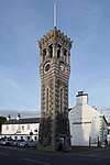 | |||
| 15-17 (Odd Nos) High Street | 54°52′59″N 4°10′56″W | Category B | 32071 | | |||
| High Street, Rutherford Hall | 54°52′53″N 4°11′10″W | Category B | 32094 | |
Key
The scheme for classifying buildings in Scotland is:
- Category A: "buildings of national or international importance, either architectural or historic; or fine, little-altered examples of some particular period, style or building type."[1]
- Category B: "buildings of regional or more than local importance; or major examples of some particular period, style or building type, which may have been altered."[1]
- Category C: "buildings of local importance; lesser examples of any period, style, or building type, as originally constructed or moderately altered; and simple traditional buildings which group well with other listed buildings."[1]
In March 2016 there were 47,288 listed buildings in Scotland. Of these, 8% were Category A, and 50% were Category B, with the remaining 42% being Category C.[2]
Notes
- Sometimes known as OSGB36, the grid reference (where provided) is based on the British national grid reference system used by the Ordnance Survey.
• "Guide to National Grid". Ordnance Survey. Retrieved 2007-12-12.
• "Get-a-map". Ordnance Survey. Retrieved 2007-12-17. - Historic Environment Scotland assign a unique alphanumeric identifier to each designated site in Scotland, for listed buildings this always begins with "LB", for example "LB12345".
gollark: * code
gollark: If you edit the coe.
gollark: Well, it ism
gollark: @Terrariola#0000 Why would squid add that?
gollark: @Terrariola#0000 No.
References
- All entries, addresses and coordinates are based on data from Historic Scotland. This data falls under the Open Government Licence
- "What is Listing?". Historic Environment Scotland. Retrieved 29 May 2018.
- Scotland's Historic Environment Audit 2016 (PDF). Historic Environment Scotland and the Built Environment Forum Scotland. pp. 15–16. Retrieved 29 May 2018.
This article is issued from Wikipedia. The text is licensed under Creative Commons - Attribution - Sharealike. Additional terms may apply for the media files.