Chelsea, London
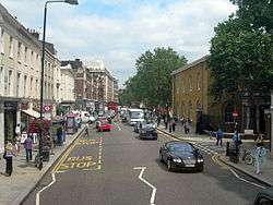
Chelsea is an area of South West London,[2] bounded to the south by the River Thames. Its river frontage runs from Chelsea Bridge along the Chelsea Embankment, Cheyne Walk, Lots Road and Chelsea Harbour. Its eastern boundary was once defined by the River Westbourne, which is now in a pipe above Sloane Square Underground station. The modern eastern boundary is Chelsea Bridge Road and the lower half of Sloane Street, including Sloane Square. To the north and northwest, the area fades into Knightsbridge and Brompton, but it is considered that the area north of King's Road as far northwest as Fulham Road is part of Chelsea.
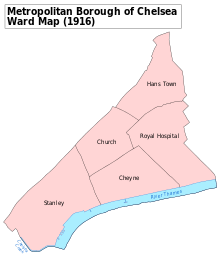
The district lies entirely within the Royal Borough of Kensington and Chelsea, although Chelsea gives its name to nearby locations, such as Chelsea Harbour in the London Borough of Hammersmith and Fulham, and Chelsea Barracks in the City of Westminster. From 1900, and until the creation of Greater London in 1965, it formed the Metropolitan Borough of Chelsea in the County of London.
The exclusivity of Chelsea as a result of its high property-prices historically resulted in the coining of the term "Sloane Ranger" in the 1970s to characterise its residents. Since 2011 Channel 4 has broadcast a reality-television show called Made in Chelsea, documenting the lives of affluent young people living there. Chelsea is home to one of the largest communities of Americans living outside the United States, with 6.53% of Chelsea residents having been born in the US.[3]
History
Early history
The word Chelsea (also formerly Chelceth, Chelchith, or Chelsey,[4]) originates from the Old English term for "landing place [on the river] for chalk or limestone" (Cealc-hyð: chalk-wharf, in Anglo-Saxon). Chelsea hosted the Synod of Chelsea in 787 AD. The first record of the Manor of Chelsea precedes the Domesday Book and records the fact that Thurstan, governor of the King's Palace during the reign of Edward the Confessor (1042–1066), gave the land to the Abbot and Convent of Westminster. Abbot Gervace subsequently assigned the manor to his mother, and it passed into private ownership. By 1086 the Domesday Book records that Chelsea was in the hundred of Ossulstone in Middlesex, with Edward of Salisbury as tenant-in-chief.[5]
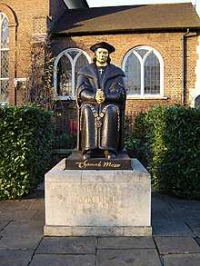
King Henry VIII acquired the manor of Chelsea from Lord Sandys in 1536; Chelsea Manor Street is still extant. Two of King Henry's wives, Catherine Parr and Anne of Cleves, lived in the Manor House; Princess Elizabeth – the future Queen Elizabeth I – resided there; and Thomas More lived more or less next door at Beaufort House. In 1609 James I established a theological college, "King James's College at Chelsey" on the site of the future Royal Hospital Chelsea, which Charles II founded in 1682.

By 1694, Chelsea – always a popular location for the wealthy, and once described as "a village of palaces" – had a population of 3,000. Even so, Chelsea remained rural and served London to the east as a market garden, a trade that continued until the 19th-century development boom which caused the final absorption of the district into the metropolis. The street crossing that was known as Little Chelsea, Park Walk, linked Fulham Road to King's Road and continued to the Thames and local ferry down Lover's Lane, renamed "Milmans Street" in the 18th century.
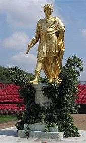
King's Road, named for Charles II, recalls the King's private road from St James's Palace to Fulham, which was maintained until the reign of George IV. One of the more important buildings in King's Road, the former Chelsea Town Hall, popularly known as "Chelsea Old Town hall" – a fine neo-classical building – contains important frescoes. Part of the building contains the Chelsea Public Library. Almost opposite stands the former Odeon Cinema, now Habitat, with its iconic façade which carries high upon it a large sculptured medallion of the now almost-forgotten William Friese-Greene, who claimed to have invented celluloid film and cameras in the 1880s before any subsequent patents.
According to Encyclopædia Britannica, "the better residential portion of Chelsea is the eastern, near Sloane Street and along the river; the western, extending north to Fulham Road, is mainly a poor quarter". This is no longer the case, although housing trusts and Council property do remain. The areas to the west also attract very high prices. This former fashionable village was absorbed into London during the eighteenth century. Many notable people of 18th century London, such as the bookseller Andrew Millar, were both married and buried in the district.[6]
The memorials in the churchyard of Chelsea Old Church, near the river, illustrate much of the history of Chelsea. These include Lord and Lady Dacre (1594/1595); Lady Jane Cheyne (1698); Francis Thomas, "director of the china porcelain manufactory"; Sir Hans Sloane (1753); Thomas Shadwell, Poet Laureate (1692). The intended tomb Sir Thomas More erected for himself and his wives can also be found there, though More is not in fact buried here.
In 1718, the Raw Silk Company was established in Chelsea Park, with mulberry trees and a hothouse for raising silkworms. At its height in 1723, it supplied silk to Caroline of Ansbach, then Princess of Wales.[7]
Chelsea once had a reputation for the manufacture of Chelsea buns, made from a long strip of sweet dough tightly coiled, with currants trapped between the layers, and topped with sugar. The Chelsea Bun House sold these during the 18th century and was patronised by the Georgian royalty. At Easter, great crowds would assemble on the open spaces of the Five Fields – subsequently developed as Belgravia. The Bun House would then do a great trade in hot cross buns and sold about quarter of a million on its final Good Friday in 1839.[8][9]
The area was also famous for its "Chelsea China" ware, though the works, the Chelsea porcelain factory – thought to be the first workshop to make porcelain in England – were sold in 1769, and moved to Derby. Examples of the original Chelsea ware fetch high values.
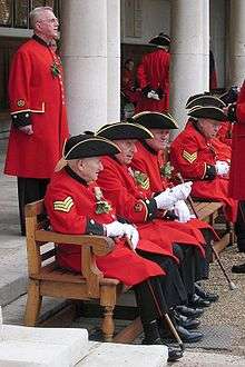
The best-known building is Chelsea Royal Hospital for old soldiers, set up by Charles II (supposedly on the suggestion of Nell Gwynne), and opened in 1694. The beautifully proportioned building by Christopher Wren stands in extensive grounds, where the Chelsea Flower show is held annually. The former Duke of York's Barracks (built 1801-3) off King's Road is now part of Duke of York Square, a redevelopment including shops and cafes and the site of a weekly "farmers' market". The Saatchi Gallery opened in the main building in 2008. Chelsea Barracks, at the end of Lower Sloane Street, was also in use until recently, primarily by ceremonial troops of the Household Division. Situated on the Westminster side of Chelsea Bridge Road, it was bought for re-development by a property group from Qatar.

Chelsea's modern reputation as a centre of innovation and influence originated in a period during the 19th century, when the area became a Victorian artists' colony (see Borough of artists below). It became prominent once again as one of the centres of the "Swinging London" of the 1960s, when house prices were lower than in the staid Royal Borough of Kensington.
The borough of artists
Chelsea once had a reputation as London's bohemian quarter, the haunt of artists, radicals, painters and poets. Little of this seems to survive now – the comfortable squares off King's Road are homes to, amongst others, investment bankers and film stars. The Chelsea Arts Club continues in situ; however, the Chelsea College of Art and Design, founded in 1895 as the Chelsea School of Art, moved from Manresa Road to Pimlico in 2005.
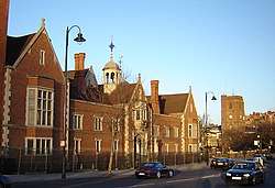
Its reputation stems from a period in the 19th century when it became a sort of Victorian artists' colony: painters such as James Webb, Dante Gabriel Rossetti, J. M. W. Turner, James McNeill Whistler, William Holman Hunt, and John Singer Sargent all lived and worked here. There was a particularly large concentration of artists in the area around Cheyne Walk and Cheyne Row, where the Pre-Raphaelite movement had its heart. The artist Prunella Clough was born in Chelsea in 1919.
The architect John Samuel Phene lived at No. 2 Upper Cheyne Row between 1903 and his death in 1912. He installed numerous artefacts and objets d'art around the house and gardens and it was known locally as the "Gingerbread Castle". It was demolished in 1924.[10]
Chelsea was also home to writers such as George Meredith, Algernon Charles Swinburne, Leigh Hunt and Thomas Carlyle. Jonathan Swift lived in Church Lane, Richard Steele and Tobias Smollett in Monmouth House. Carlyle lived for 47 years at No. 5 (now 24) Cheyne Row. After his death, the house was bought and turned into a shrine and literary museum by the Carlyle Memorial Trust, a group formed by Leslie Stephen, father of Virginia Woolf. Virginia Woolf set her 1919 novel Night and Day in Chelsea, where Mrs. Hilbery has a Cheyne Walk home.
In a book, Bohemia in London by Arthur Ransome which is a partly fictional account of his early years in London, published in 1907 when he was 23, there are some fascinating, rather over-romanticised accounts of bohemian goings-on in the quarter. The American artist Pamela Colman Smith, the designer of A. E. Waite's Tarot card pack and a member of the Hermetic Order of the Golden Dawn, features as "Gypsy" in the chapter "A Chelsea Evening".
A central part of Chelsea's artistic and cultural life was Chelsea Public Library, originally situated in Manresa Road. Its longest serving member of staff was Armitage Denton, who joined in 1896 at the age of 22, and he remained there until his retirement in 1939; he was appointed Chief Librarian in 1929. In 1980, the building was purchased by Chelsea College of Art and Design.
The Chelsea Collection is a priceless anthology of prints and pictures of old Chelsea. Begun in 1887, it contains works by artists as notable and diverse as Rossetti and Whistler. During his time at the Library, Armitage Denton built the Collection assiduously, so that by the time of his death in July 1949 it numbered more than 1,000 items. At the end of the 20th century, the Collection totalled more than 5,000 works, and it continues to grow.
The Chelsea Society, formed in 1927, remains an active amenity society concerned with preserving and advising on changes in Chelsea's built environment. Chelsea Village and Chelsea Harbour are new developments outside of Chelsea itself.
Swinging Chelsea and today
Chelsea shone again, brightly but briefly, in the 1960s Swinging London period and the early 1970s. The Swinging Sixties was defined on King's Road, which runs the length of the area. The Western end of Chelsea featured boutiques Granny Takes a Trip and The Sweet Shop, the latter of which sold medieval silk velvet caftans, tabards and floor cushions, with many of the cultural cognoscenti of the time being customers, including Twiggy and many others.
The "Chelsea girl" was symbol of, John Crosby wrote, what "men [found] utterly captivating", with a "'life is fabulous' philosophy".[11] Chelsea at this time was home to the Beatles and to Rolling Stones members Brian Jones, Mick Jagger, and Keith Richards. In the 1970s, the World's End area of King's Road was home to Malcolm McLaren and Vivienne Westwood's boutique "SEX", and saw the birth of the British punk movement.
By the late 1970s, the growing bohemian and punk population moved from Chelsea into nearby Notting Hill and further north to Camden Town, with the rapid gentrification of the two areas, both of which remain places with a significant population of artists, musicians and those who work in other creative industries, particularly Camden Town.
King's Road remains the major artery through Chelsea and a busy road, and despite its continuing reputation as a shopping mecca, is now home to many of the same shops found on other British high streets, such as Gap, and McDonald's. Sloane Street is quickly catching up with Bond Street as one of London's premier shopping destinations, housing a variety of high-end fashion or jewellery boutiques such as Cartier, Tiffany & Co, Dolce & Gabbana, Prada, Gucci, Harrods, Dior, Louis Vuitton, Jimmy Choo, Giorgio Armani, Yves Saint Laurent, Chanel, Valentino, Bvlgari, Gianni Versace and Graff.
Incidents
On 27 November 1974, the London unit of the Provisional Irish Republican Army exploded twin bombs on Tite Street, injuring 20 people.[12]
Sport
In the 18th century, Chelsea Cricket Club was prominent for a time and played its home matches on what was then Chelsea Common, an area that virtually disappeared under building work in the 19th century.[13] Records have survived of five important matches between 1731 and 1789 which involved the Chelsea club and/or were played on the common.[14][15]
Chelsea Football Club is located at Stamford Bridge in neighbouring Fulham, close to the border with Chelsea. As a result of Chelsea's expensive location and wealthy residents, Chelsea F.C. has the wealthiest local supporters in England.[16] The club is owned by Russian billionaire and Chelsea resident, Roman Abramovich.
Geography
Notable residents
Property

Chelsea consists of two main postcodes (SW3 and SW10) but also includes small sections of SW1. All of Chelsea is, by definition, in the Royal Borough of Kensington and Chelsea (RBKC). On the eastern side RBKC meets the borough of the City of Westminster (COW), this meets at Chelsea Bridge Road where the postcode is SW1W, with one side of the road being in COW and the other in RBKC.
The vast majority of Chelsea lies in the prestigious SW3 postcode. The far west of Chelsea is SW10 and SW5 but due to the absence of tube coverage in large parts of the Borough, most people in SW10 use Earls Court or Fulham Broadway tube stations.
The most desirable part of Chelsea is around Sloane Square and Knightsbridge tube. Around here, Chelsea meets Knightsbridge. This property market attracts considerable (international) attention, and is a very complex market as it consists mainly of short leases under Earl Cadogan as freeholder. Much of Chelsea is now viewed as a "Global Ultra Prime Residential Area".
Much of Chelsea (SW3) and Knightsbridge (SW1X) is still owned by Earl Cadogan, through the Cadogan Estates. Most of the property owned is in and around Cadogan Square. This has a major influence on the markets as the Earl is the freeholder and generally has no desire to sell; although changes in legislation now mean the freeholder is obliged to sell lease extensions to a leaseholder at prices which are determined by the Leasehold valuation tribunal. Lord Cadogan is generally regarded as an effective and successful property developer/landlord being responsible, together with his management team, for bringing all of the fashion labels to Sloane Street, and also forward thinking developments on his own account at Duke of York Square on King's Road, at Peter Jones and on Sloane Street. The Cadogan Estate has a considerable portfolio of retail property throughout Chelsea but notably on Fulham Road, King's Road, and Sloane Street including Peter Jones, Harvey Nichols, and 12 hotels including the Cadogan Hotel. The Estate maintains many of the garden squares, (to which local residents can gain access by subscribing for an annual fee – and optionally the tennis courts where applicable). The area is home to several open spaces including Albert Bridge Gardens, Battersea Bridge Gardens, Chelsea Embankment Gardens, Royal Hospital Chelsea: the grounds of which are used by the annual Chelsea Flower Show and Chelsea Physic Garden.[17]
Transport
Buses
Chelsea is served by many Transport for London bus services.
Tube and rail
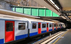
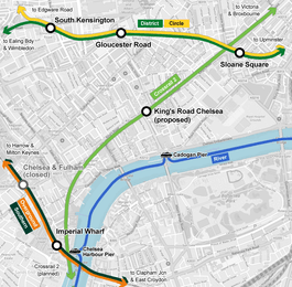
Chelsea does not currently have its own Underground station, but Chelsea is linked to the network on it eastern edge of the district at Sloane Square with a station of the same name for the District and Circle lines. The station opened on 24 December 1868 by the District Railway (DR, now the District line) when the company opened the first section of its line between South Kensington and Westminster stations.[18]
Imperial Wharf railway station at Chelsea Harbour on the West London Line, which is on the southwestern edge of Chelsea. London Overground and Southern trains stop here.
A Chelsea railway station (later renamed Chelsea and Fulham) previously existed on this line, located between the King's Road and the Fulham Road in neighbouring Fulham, but this was closed in 1940 following World War II bomb damage and later demolished.[19]
There is a proposal to construct a Chelsea Underground station on the King's Road as part of the Crossrail 2 project (also known as the Chelsea-Hackney line). The project, run by Transport for London, has not yet been approved or funded but is at the consultation stage.[20] According to plans published by TfL in 2008, it is envisaged that the station would be located on the Dovehouse Green area of King's Road.[21]
References
- Cremorne, Stanley, Royal Hospital, Redcliffe and Hans town wards 2011 http://www.ukcensusdata.com/kensington-and-chelsea-e09000020#sthash.KkJ8v3td.dpbs Archived 16 June 2017 at the Wayback Machine
- Mayor of London (2008). "Map 5G.1 - Central Activities Zone". London Plan. Greater London Authority. Archived from the original on 28 May 2014. Retrieved 27 May 2014.
- BBC Born Abroad Data. News.bbc.co.uk.
-
Lysons, Daniel (1811) [⏯]. The Environs of London: Being an Historical Account of the Towns, Villages, and Hamlets, Within Twelve Miles of that Capital: Interspersed with Biographical Anecdotes. 2 (2 ed.). London. p. 45. Retrieved 14 May 2013.
[...] the most common mode of spelling for some centuries after the Conquest, was Chelceth or Chelchith; in the 16th century it began to be written Chelsey; the modern way of spelling seems to have been first used about a century ago.
- Open Domesday Online: Chelsea, accessed April 2017
- "The manuscripts, Letter from Andrew Millar to Andrew Mitchell, 26 August, 1766. Andrew Millar Project. University of Edinburgh". www.millar-project.ed.ac.uk. Retrieved 3 June 2016.
- Patricia E.C. Croot, ed. (2004). "Economic history: Trade and industry". A History of the County of Middlesex: Volume 12: Chelsea. Institute of Historical Research.
- "Chelsea Bun House", London Encyclopaedia, Pan Macmillan, 2010, p. 155, ISBN 9781405049252
- George Bryan (1869), "The Original Chelsea Bunhouse", Chelsea, in the Olden & Present Times, London, pp. 200–202
- Weinreb, Ben; Hibbert, Christopher; Keay, John; Keay, Julia (2008). The London Encyclopaedia (2nd ed.). Pan Macmillan. p. 961. ISBN 978-1-405-04924-5.
- Seebohm, Caroline (19 July 1971). "English Girls in New York: They Don't Go Home Again". New York. p. 34. Retrieved 6 January 2015.
- "CAIN: Chronology of the Conflict 1974".
- "Chelsea Common". www.rbkc.gov.uk.
- Waghorn, Dawn of Cricket, p. 9.
- Buckley, FL18C, p. 8.
- Premiership clubs by fans' wealth. Talktalk.co.uk.
- "Private Gynaecologist". Retrieved 28 November 2014.
- Rose 1999.
- "Chelsea & Fulham". Disused Stations. Subterranea Britannica. Retrieved 31 July 2013.
- "Regional route". Projects and Schemes – Crossrail 2. Transport for London. Archived from the original on 29 July 2013. Retrieved 1 August 2013.
- "Crossrail 2 safeguarding directions plan part 1 (Wimbledon to Chelsea) - sheet 16" (PDF). March 2015. Archived from the original (PDF) on 1 May 2015. Retrieved 1 May 2015.
Bibliography
- Buckley, G. B. (1935). Fresh Light on 18th Century Cricket. Cotterell.
- Buckley, G. B. (1937). Fresh Light on pre-Victorian Cricket. Cotterell.
- Waghorn, H. T. (1906). The Dawn of Cricket. Electric Press.
- Wilson, Martin (2005). An Index to Waghorn. Bodyline.
Further reading
- Daniel Lysons (1792), "Chelsea", Environs of London, 2: County of Middlesex, London: T. Cadell
- "Chelsea". Chambers's Encyclopaedia. London. 1901.
- Findlay Muirhead, ed. (1922), "Chelsea", London and its Environs (2nd ed.), London: Macmillan & Co., OCLC 365061
- "Chelsea". London. Let's Go. 1998. p. 156+. OL 24256167M.
External links
| Wikimedia Commons has media related to Chelsea, London. |
- Chelsea, The Fascination of London by G. E. Mitton
- LivingBorough – Chelsea via articles, images and videos
- Digital Public Library of America. Works related to Chelsea, London, various dates
- Chelsea Independent College
