Lemoyne, Pennsylvania
Lemoyne is a borough in Cumberland County, Pennsylvania, United States. Lemoyne was incorporated as a borough on May 23, 1905. As of the 2010 census, the borough population was 4,553.[4] It was formerly named "Bridgeport". Lemoyne lies across the Susquehanna River from Harrisburg, Pennsylvania's capital. It is part of the Harrisburg–Carlisle Metropolitan Statistical Area.
Lemoyne, Pennsylvania Bridgeport | |
|---|---|
 | |
| Motto(s): "The little town that has it all!" | |
 Location of Lemoyne in Cumberland County, Pennsylvania. | |
 Lemoyne Location in Pennsylvania and the United States  Lemoyne Lemoyne (the United States) | |
| Coordinates: 40°14′39″N 76°53′56″W | |
| Country | United States |
| State | Pennsylvania |
| County | Cumberland |
| Settled (as Bridgeport) | 1835 |
| Settled (as Riverton) | 1888 |
| Incorporated | May 23, 1905 |
| Named for | French soldier Charles LeMoyne |
| Government | |
| • Type | Council–manager |
| • Mayor | David Beasley |
| • Borough Manager | Cindy L. Foster |
| • Council President | Gale Gallo |
| • Council Vice President | Sue Yenchko |
| • Council Member | List of Council Members
|
| Area | |
| • Total | 1.61 sq mi (4.18 km2) |
| • Land | 1.61 sq mi (4.18 km2) |
| • Water | 0.00 sq mi (0.00 km2) |
| Elevation | 384 ft (117 m) |
| Population | |
| • Total | 4,553 |
| • Estimate (2019)[5] | 4,634 |
| • Density | 2,874.69/sq mi (1,109.85/km2) |
| Time zone | UTC−05:00 (EST) |
| • Summer (DST) | UTC−04:00 (EDT) |
| ZIP Code | 17043 |
| Area codes | 717 and 223 |
| FIPS code | 42-42648 |
| Website | www |
Lemoyne is served by Interstate 83 and U.S. Routes 11/15. Lemoyne is served by the West Shore School District.
Geography
Lemoyne is located on the eastern edge of Cumberland County at 40°14′39″N 76°53′56″W (40.244217, -76.899119),[6] on the west bank of the Susquehanna River, directly across from Harrisburg. It is bordered to the north by Wormleysburg, to the west by Camp Hill, and to the south by the borough of New Cumberland and Lower Allen Township.
According to the United States Census Bureau, the borough has a total area of 1.612 square miles (4.18 km2), all of it land.[6]
Demographics
| Historical population | |||
|---|---|---|---|
| Census | Pop. | %± | |
| 1910 | 1,393 | — | |
| 1920 | 1,939 | 39.2% | |
| 1930 | 4,171 | 115.1% | |
| 1940 | 4,358 | 4.5% | |
| 1950 | 4,605 | 5.7% | |
| 1960 | 4,662 | 1.2% | |
| 1970 | 4,625 | −0.8% | |
| 1980 | 4,178 | −9.7% | |
| 1990 | 3,959 | −5.2% | |
| 2000 | 3,995 | 0.9% | |
| 2010 | 4,553 | 14.0% | |
| Est. 2019 | 4,634 | [5] | 1.8% |
As of the 2010 Census, there were 4,553 people, with a population density of 2,824.4/sq mi (1,090.5/km2) in the borough.[8] There were 2,363 housing units at an average density of 1,465.3/sq mi (565.74/km2).[9]
Age and sex
The median age was 38.3 years, with 264 (5.8%) under the age of 5, 628 (13.8%) in the 5 to 17 age range, 121 (2.7%) in the 18 to 20 age range, 253 (5.6%) in the 21 to 24 age range, 806 (17.7%) in the 25 to 34 age range, 605 (13.3%) in the 35 to 44 age range, 664 (14.6%) in the 45 to 54 age range, 325 (7.1%) in the 55 to 59 age range, 282 (6.2%) in the 60 to 64 age range, 273 (6%) in the 65 to 74 age range, 206 (4.5%) in the 75 to 84 age range, and 126 (2.8%) age 85 and over. 892 (19.6%) were under the age 18 and 605 (13.3%) were age 65 and over. 2,323 (51%) of the population were females, giving a ratio of 100∶96.0 females to males. 1,876 (51.2%) of those over the age of 18 were female with 360 (59.5%) of those age 65 and over being female.[9]
Race and Hispanic or Latino origin
The racial and ethnic makeup of the borough was 4,114 (90.36%) white, 118 (2.59%) African American or Black, 12 (0.26%) American Indian or Alaska Native, 72 (1.58%) Asian, 1 (0.02%) Native Hawaiian and other Pacific Islander, 100 (2.2%) from some other race, and 136 (2.99%) from two or more races. 232 (5.1%) were Hispanic or Latino of any race.[9]
Households and families
There were 2,160 households, with 1,706 (79%) being considered families. The average size of a household was 2.11 and of families 2.85. 44% of the families had children under the age of 18. 764 (71%) of the families were a husband-wife family, 38% of those having children under the age of 18. 228 (21.2%) of families had a female householder with no husband present, 58% of those having children under the age of 18. 84 (7.8%) of families were of some other classification. There were 1,084 (50.2%) households not considered a family, with 850 (78.4%) of those being someone living alone 239 (28.1%) being age 65 and over.[9]
Notable people
- Bob Adams, baseball pitcher
- Edson Hendricks, computer scientist
- Stan Jones, football player
- Paul Minner, baseball pitcher
- Bob Moorhead, baseball pitcher
- Andy Musser, sports announcer
- Dean T. Stevenson, Episcopal bishop
- Helen Waddell, baseball player
References
- "Borough Council". Lemoyne, PA. Archived from the original on July 13, 2020. Retrieved July 13, 2020.
- "Administration". Lemoyne, PA. Archived from the original on July 13, 2020. Retrieved July 13, 2020.
- "2019 U.S. Gazetteer Files". United States Census Bureau. Retrieved July 28, 2020.
- "Annual Estimates of the Resident Population for Incorporated Places in Pennsylvania: April 1, 2010 to July 1, 2019". United States Census Bureau. Archived from the original on July 13, 2020. Retrieved July 13, 2020.
- "Population and Housing Unit Estimates". United States Census Bureau. May 24, 2020. Retrieved May 27, 2020.
- "2019 U.S. Gazetteer Files". United States Census Bureau. Archived from the original on July 13, 2020. Retrieved July 13, 2020.
- "Census of Population and Housing". Census.gov. Retrieved June 4, 2016.
- Pennsylvania: 2010 Population and Housing Unit Counts (PDF). 2010 Census (Report). United States Census Bureau. August 2012. p. 29. Archived (PDF) from the original on July 13, 2020. Retrieved July 13, 2020.
- Pennsylvania: 2010 Population and Housing Characteristics (PDF). 2010 Census (Report). United States Census Bureau. December 2012. Retrieved July 13, 2020.
Municipalities and communities of Cumberland County, Pennsylvania, United States | ||
|---|---|---|
| Boroughs | 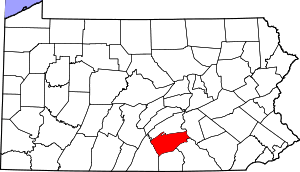 | |
| Townships | ||
| CDPs | ||
| Unincorporated communities | ||
| Footnotes | ‡This populated place also has portions in an adjacent county or counties | |
| Authority control |
|
|---|