Williamstown, Pennsylvania
Williamstown is a borough in Dauphin County, Pennsylvania, United States, 38 miles (61 km) northeast of Harrisburg. Formerly, anthracite coal mines were here, as well as hosiery mills. The population was 1,387 at the 2010 census.[3]
Williamstown, Pennsylvania | |
|---|---|
 Location in Dauphin County and the U.S. state of Pennsylvania. | |
 Williamstown Location in Pennsylvania and the United States  Williamstown Williamstown (the United States) | |
| Coordinates: 40°34′52″N 76°37′06″W | |
| Country | United States |
| State | Pennsylvania |
| County | Dauphin |
| Settled | 1869 |
| Incorporated | 1877 |
| Government | |
| • Type | Borough Council |
| Area | |
| • Total | 0.26 sq mi (0.67 km2) |
| • Land | 0.26 sq mi (0.67 km2) |
| • Water | 0.00 sq mi (0.00 km2) |
| Elevation | 866 ft (264 m) |
| Population (2010) | |
| • Total | 1,387 |
| • Estimate (2019)[2] | 1,386 |
| • Density | 5,351.35/sq mi (2,064.51/km2) |
| Time zone | UTC-5 (Eastern (EST)) |
| • Summer (DST) | UTC-4 (EDT) |
| ZIP code | 17098 |
| Area code(s) | 717 |
| FIPS code | 42-85320 |
Williamstown is part of the Harrisburg–Carlisle Metropolitan Statistical Area.
Geography
Williamstown is located in northeastern Dauphin County at 40°34′52″N 76°37′6″W (40.581075, -76.618296).[4] It is in the valley of Wiconisco Creek, between Big Lick Mountain to the north and Peters Mountain to the south. U.S. Route 209 passes to the south of the borough, leading northeast 24 miles (39 km) to Pottsville and west 11 miles (18 km) to Elizabethville.
According to the United States Census Bureau, the borough has a total area of 0.26 square miles (0.67 km2), all of it land.[3]
Demographics
| Historical population | |||
|---|---|---|---|
| Census | Pop. | %± | |
| 1880 | 1,771 | — | |
| 1890 | 2,324 | 31.2% | |
| 1900 | 2,934 | 26.2% | |
| 1910 | 2,904 | −1.0% | |
| 1920 | 2,878 | −0.9% | |
| 1930 | 2,958 | 2.8% | |
| 1940 | 2,769 | −6.4% | |
| 1950 | 2,332 | −15.8% | |
| 1960 | 2,097 | −10.1% | |
| 1970 | 1,919 | −8.5% | |
| 1980 | 1,664 | −13.3% | |
| 1990 | 1,509 | −9.3% | |
| 2000 | 1,433 | −5.0% | |
| 2010 | 1,387 | −3.2% | |
| Est. 2019 | 1,386 | [2] | −0.1% |
| Sources:[5][6][7] | |||
As of the census[6] of 2000, there were 1,433 people, 611 households, and 406 families residing in the borough. The population density was 5,692.2 people per square mile (2,213.1/km²). There were 716 housing units at an average density of 2,844.1 per square mile (1,105.8/km²). The racial makeup of the borough was 99.02% White, 0.14% African American, 0.07% Native American, 0.21% Asian, 0.07% from other races, and 0.49% from two or more races. Hispanic or Latino of any race were 0.35% of the population.
There were 611 households, 25.7% of which included children under the age of 18. 49.3% were married couples living together, 11.6% had a female householder, and 33.4% were non-families. 29.0% of all households consisted of individuals, and 15.9% were single residents 65 years of age or older. The average household size was 2.35 and the average family size was 2.83.
The borough population included 21.8% under the age of 18; 8.0% from 18 to 24; 27.5% from 25 to 44; 22.0% from 45 to 64; and 20.7% who were 65 years of age or older. The median age was 40 years. For every 100 females there were 90.1 males. For every 100 females age 18 and over, there were 86.5 males.
The median income for a household in the borough was $33,359, and the median income for a family was $36,548. Males had a median income of $31,855 versus $23,125 for females. The per capita income for the borough was $15,744. About 11.9% of families and 14.7% of the population were below the poverty line, including 18.6% of those under age 18 and 10.8% of those age 65 or over.
Notable people
- Gary Collins, NFL player for the Cleveland Browns from 1961 to 1972.
References
- "2019 U.S. Gazetteer Files". United States Census Bureau. Retrieved July 28, 2020.
- "Population and Housing Unit Estimates". United States Census Bureau. May 24, 2020. Retrieved May 27, 2020.
- "Geographic Identifiers: 2010 Demographic Profile Data (G001): Williamstown borough, Pennsylvania". U.S. Census Bureau, American Factfinder. Archived from the original on February 13, 2020. Retrieved December 16, 2015.
- "US Gazetteer files: 2010, 2000, and 1990". United States Census Bureau. February 12, 2011. Retrieved April 23, 2011.
- "Census of Population and Housing". U.S. Census Bureau. Retrieved December 11, 2013.
- "U.S. Census website". United States Census Bureau. Retrieved January 31, 2008.
- "Incorporated Places and Minor Civil Divisions Datasets: Subcounty Resident Population Estimates: April 1, 2010 to July 1, 2012". Population Estimates. U.S. Census Bureau. Retrieved December 11, 2013.
External links
Municipalities and communities of Dauphin County, Pennsylvania, United States | ||
|---|---|---|
| City | 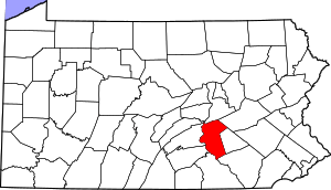 | |
| Boroughs | ||
| Townships | ||
| CDPs | ||
| Unincorporated communities |
| |
| Authority control |
|
|---|