Enhaut, Pennsylvania
Enhaut is an unincorporated community and census-designated place (CDP) located in Dauphin County in the state of Pennsylvania. The community was formerly part of the census-designated place of Bressler-Enhaut-Oberlin, before splitting into three separate CDPs for the 2010 census. As of the 2010 census the population in Enhaut was 1,007.[1]
Enhaut, Pennsylvania | |
|---|---|
 Location in Dauphin County and state of Pennsylvania. | |
| Country | United States |
| State | Pennsylvania |
| County | Dauphin |
| Township | Swatara |
| Area | |
| • Total | 0.23 sq mi (0.60 km2) |
| • Land | 0.23 sq mi (0.60 km2) |
| • Water | 0.0 sq mi (0.0 km2) |
| Elevation | 490 ft (150 m) |
| Population (2010) | |
| • Total | 1,007 |
| • Density | 4,366/sq mi (1,685.9/km2) |
| Time zone | UTC-5 (Eastern (EST)) |
| • Summer (DST) | UTC-4 (EDT) |
| FIPS code | 42-23704 |
| GNIS feature ID | 1174268 |
Enhaut is in Swatara Township and is bordered to the southwest by the borough of Steelton, to the southeast by Bressler, and to the northeast by Oberlin. It is 4 miles (6 km) southeast of the state capitol in Harrisburg.
References
- "Geographic Identifiers: 2010 Demographic Profile Data (G001): Enhaut CDP, Dauphin County, Pennsylvania". U.S. Census Bureau, American Factfinder. Archived from the original on February 13, 2020. Retrieved December 22, 2015.
Municipalities and communities of Dauphin County, Pennsylvania, United States | ||
|---|---|---|
| City | 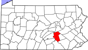 | |
| Boroughs | ||
| Townships | ||
| CDPs | ||
| Unincorporated communities |
| |
This article is issued from Wikipedia. The text is licensed under Creative Commons - Attribution - Sharealike. Additional terms may apply for the media files.