List of listed buildings in Peebles, Scottish Borders
List
| Name | Location | Date Listed | Grid Ref. [note 1] | Geo-coordinates | Notes | LB Number [note 2] | Image |
|---|---|---|---|---|---|---|---|
| 11And 15 Northgate | 55°39′09″N 3°11′21″W | Category C(S) | 39240 |  | |||
| Old Town, Remains Of St Andrews Church | 55°39′10″N 3°11′57″W | Category B | 39248 | | |||
| Rosetta Road, Kingsland Primary School, With Janitor's House, Boundary Walls, Shelters, Gatepiers And Railings | 55°39′26″N 3°11′51″W | Category B | 39255 | | |||
| Springhill Road, Barima With Boundary Walls | 55°38′54″N 3°11′24″W | Category C(S) | 39266 | | |||
| 4 Springhill Road, Falcony Cottage | 55°38′56″N 3°11′28″W | Category C(S) | 39269 | | |||
| 10 Springhill Road, Cruachan | 55°38′56″N 3°11′27″W | Category C(S) | 39272 | | |||
| Springwood Road And Springwood Terrace, Springwood Lodge With Boundary Walls | 55°38′47″N 3°11′24″W | Category B | 39275 | | |||
| Venlaw Road And Edinburgh Road, Holland And Sherry Warehouse And Offices With Boundary Walls | 55°39′14″N 3°11′17″W | Category B | 39285 | | |||
| 1 And 2 Venlaw Road | 55°39′10″N 3°11′15″W | Category C(S) | 39287 | | |||
| West Port, The Bridge Inn (And Nanking Chinese Restaurant) | 55°39′04″N 3°11′34″W | Category B | 39288 | | |||
| 1 Bridgegate | 55°39′08″N 3°11′21″W | Category C(S) | 39152 | | |||
| Caledonian Road, Bridgelands And Rowanbank With Boundary Wall And Gatepiers | 55°38′56″N 3°11′44″W | Category C(S) | 39153 | | |||
| 10 Crossland Crescent With Boundary Walls | 55°39′10″N 3°11′40″W | Category B | 39159 | | |||
| Damdale, Footbridge | 55°39′18″N 3°11′26″W | Category C(S) | 39160 | | |||
| 36-40 (Even Nos) Dean Park, Edinburgh Road | 55°39′18″N 3°11′21″W | Category C(S) | 39163 | | |||
| Edderston Road, Craigerne School With Coach House And Lodge | 55°38′31″N 3°11′44″W | Category B | 39168 | | |||
| 16 Elcho Street, Graham Cottage, With Front Wall, Railings And Gatepiers | 55°39′11″N 3°11′31″W | Category C(S) | 39174 | | |||
| 5-11 (Odd Nos) High Street (Incorporating The Keg Lounge Bar) | 55°39′06″N 3°11′21″W | Category B | 39190 | | |||
| 63-67 (Odd Nos) High Street | 55°39′04″N 3°11′31″W | Category C(S) | 39195 | | |||
| 18 And 20 High Street, The Medical Hall | 55°39′07″N 3°11′23″W | Category B | 39199 | | |||
| Innerleithen Road, Peebles Hotel Hydro Lodge | 55°39′05″N 3°10′31″W | Category B | 39221 | | |||
| Talisman Place, Kingsmeadows Road, 1-7 (Inclusive) Kingsmeadows Stables | 55°38′47″N 3°10′45″W | Category C(S) | 39229 | | |||
| 1-5 (Inclusive Nos) Biggiesknowe, And 1-6 (Inclusive Nos) Bridge House Terrace With Forestairs And Balcony | 55°39′07″N 3°11′33″W | Category C(S) | 39140 | | |||
| 14 Biggiesknowe | 55°39′08″N 3°11′32″W | Category C(S) | 39141 | | |||
| Bonnington Road, Arnsheen, With Garage, Sundial, Gatepiers, Gates And Boundary Wall | 55°38′26″N 3°11′21″W | Category B | 39144 | | |||
| Bonnington Road, Craigmount, With Gatepiers And Boundary Walls | 55°38′27″N 3°11′25″W | Category C(S) | 39145 | | |||
| Edston Toll (Also Known As Lyne Toll) | 55°38′53″N 3°15′17″W | Category C(S) | 15208 | | |||
| Neidpath Castle Including Courtyard Buildings, Gateway, Former Walled Garden And Boundary Wall | 55°39′07″N 3°12′54″W | Category A | 13857 | 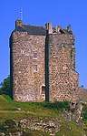 | |||
| Kingsmeadows Road, Kingsmeadows House Including Terrace, Wall, Gazebo, Gate, Gatepiers And Boundary Wall | 55°38′50″N 3°10′40″W | Category B | 47381 | | |||
| Eshiels, Council Depot (Former Gasworks), Railway Buildings, Single Shed, Office Block, Gatepiers And Boundary Wall | 55°38′47″N 3°09′31″W | Category B | 48929 | | |||
| Peebles, South Park Wood, Former Railway Tunnel | 55°39′31″N 3°11′58″W | Category B | 48931 | | |||
| Northgate, Cross Keys Inn, 13 And 26 Northgate (The Couchee Righ) | 55°39′10″N 3°11′19″W | Category B | 39237 | | |||
| 5 And 7 Northgate | 55°39′09″N 3°11′21″W | Category B | 39238 | | |||
| 43, 45 And 47 Northgate | 55°39′13″N 3°11′21″W | Category C(S) | 39241 | | |||
| Rosetta Road, St Joseph Rc Church And Presbytery, With Boundary Walls, Gate And Gatepiers (Presbytery Is 17 Rosetta Road) | 55°39′15″N 3°11′48″W | Category B | 39257 | | |||
| Rosetta Road, St Joseph's Rc Church Hall And 19 And 21 Rosetta Road, With Boundary Walls | 55°39′16″N 3°11′48″W | Category C(S) | 39258 | | |||
| Springhill Road, Victoria Park Gates And Railings | 55°38′54″N 3°11′25″W | Category C(S) | 39268 | | |||
| Talisman Place, White Cottage | 55°38′45″N 3°10′47″W | Category C(S) | 39276 | | |||
| Bonnington Road, Reiverslaw With Lodge, Gatepiers, Gates, Garage, Greenhouse And Boundary Walls | 55°38′25″N 3°11′23″W | Category B | 39149 | | |||
| 2 Bonnington Road, Kingsville | 55°38′40″N 3°11′23″W | Category C(S) | 39150 | | |||
| 7 Crossland Crescent, Edrom Villa, With Boundary Walls | 55°39′09″N 3°11′39″W | Category C(S) | 39157 | | |||
| 3 Damdale With Boundary Wall And Gate | 55°39′14″N 3°11′30″W | Category B | 39161 | | |||
| 3-9 (Odd Nos) Eastgate | 55°39′08″N 3°11′19″W | Category C(S) | 39167 | | |||
| Edinburgh Road, North Lodge, (Venlaw Castle Hotel) With Gatepiers And Boundary Walls | 55°39′45″N 3°11′34″W | Category C(S) | 39172 | | |||
| Edinburgh Road, Venlaw South Lodge With Boundary Walls And Gatepiers | 55°39′23″N 3°11′22″W | Category C(S) | 39173 | | |||
| High Street, Veitch Memorial | 55°39′05″N 3°11′27″W | Category C(S) | 39189 | | |||
| 27, 27A And 29 High Street | 55°39′06″N 3°11′24″W | Category B | 39191 | | |||
| 56 And 58 High Street | 55°39′06″N 3°11′28″W | Category C(S) | 39205 | | |||
| Innerleithen Road, Kerfield, With Bridge | 55°38′58″N 3°10′34″W | Category B | 39213 | | |||
| Innerleithen Road, Kerfield Cottage, Stable, Coach House, Barns And Associated Buildings, With Boundary Walls And Gatepiers | 55°39′00″N 3°10′32″W | Category B | 39216 | | |||
| Kingsmeadows Road, Woodbine Cottage | 55°38′57″N 3°11′22″W | Category C(S) | 39228 | | |||
| 49 March Street, Sunbury Villa With Front Walls And Railings | 55°39′16″N 3°11′45″W | Category C(S) | 39234 | | |||
| Bonnington Road, Kingsmuir Hall, Middle House, And Cottage | 55°38′44″N 3°11′19″W | Category C(S) | 39146 | | |||
| Winkston Farm House | 55°40′30″N 3°12′08″W | Category B | 15213 | | |||
| Redscarhead, George Meikle Kemp Memorial (At Moy Hall) | 55°41′02″N 3°12′38″W | Category B | 15215 | | |||
| 85 Northgate | 55°39′17″N 3°11′23″W | Category B | 39242 | | |||
| Old Town, Hay Lodge Park Gatepiers, Gates, Boundary Walls And Ice House | 55°39′08″N 3°11′57″W | Category C(S) | 39247 | | |||
| 84 Old Town | 55°39′08″N 3°11′48″W | Category C(S) | 39253 | | |||
| 1 St Andrews Place | 55°39′12″N 3°11′53″W | Category C(S) | 39261 | | |||
| St Andrews Road, Cemetery Lodge With Boundary Wall And Gates | 55°39′11″N 3°11′55″W | Category C(S) | 39264 | | |||
| Tweed Green And School Brae, Former English School With Gate And Boundary Wall | 55°39′03″N 3°11′23″W | Category C(S) | 39280 | | |||
| Venlaw High Road, Hyndlea And Rathacraig, With Boundary Walls And Railings | 55°39′14″N 3°10′56″W | Category B | 39283 | | |||
| 4, 4A And 6 Bonnington Road With Boundary Wall | 55°38′38″N 3°11′24″W | Category C(S) | 39151 | | |||
| Edderston Road, Greybield | 55°38′43″N 3°11′53″W | Category B | 39169 | | |||
| Frankscroft, Ravenscraig | 55°38′55″N 3°11′45″W | Category C(S) | 39178 | | |||
| 37 High Street | 55°39′05″N 3°11′26″W | Category B | 39192 | | |||
| 2-6 (Even Nos) High Street And 1 And 3 Northgate | 55°39′07″N 3°11′21″W | Category B | 39198 | | |||
| 50 And 52 High Street | 55°39′06″N 3°11′27″W | Category B | 39203 | | |||
| 54 High Street, Crown Hotel | 55°39′07″N 3°11′28″W | Category C(S) | 39204 | | |||
| 70, 72 And 74 High Street | 55°39′06″N 3°11′30″W | Category C(S) | 39208 | | |||
| 80 And 82 High Street | 55°39′06″N 3°11′31″W | Category C(S) | 39209 | | |||
| Innerleithen Road, Kerfield Kitchen Garden Walls | 55°38′59″N 3°10′27″W | Category C(S) | 39217 | | |||
| 8, 8A And 9 Kingsmeadows Road, St Margaret's And Fernside, With Boundary Walls And Railings | 55°38′57″N 3°11′24″W | Category C(S) | 39226 | | |||
| 19 And 21 March Street, Marion Cottage And Alexander Cottage | 55°39′17″N 3°11′36″W | Category C(S) | 39232 | | |||
| 11 Murray Place, Fairholm, With Boundary Walls | 55°39′18″N 3°11′32″W | Category C(S) | 39235 | | |||
| Neidpath Railway Viaduct (Near Neidpath Castle) | 55°38′57″N 3°13′14″W | Category A | 15206 | .jpg) | |||
| Winkston Tower House | 55°40′31″N 3°12′08″W | Category B | 15214 | | |||
| 32 And 34 Northgate With Boundary Walls And Gatepiers | 55°39′11″N 3°11′19″W | Category B | 39243 | | |||
| 40 Rosetta Road, Ratho Cottage, With Boundary Wall | 55°39′18″N 3°11′47″W | Category C(S) | 39260 | | |||
| Tweed Bridge | 55°39′02″N 3°11′34″W | Category A | 39278 | 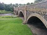 | |||
| Tweed Green, Cabbage Hall, With Boundary Wall | 55°39′04″N 3°11′20″W | Category C(S) | 39279 | | |||
| Tweedgreen, Old Rectory And Tweedbrae, East Rectory | 55°39′05″N 3°11′16″W | Category C(S) | 39282 | | |||
| Venlaw High Road, Redbraes With Gatepiers And Boundary Wall | 55°39′16″N 3°11′07″W | Category B | 39284 | | |||
| Chambers Terrace, Dalhousia | 55°38′54″N 3°11′34″W | Category B | 39154 | | |||
| Edderston Road, Tantah Lodge And Boundary Wall | 55°38′30″N 3°11′54″W | Category C(S) | 39171 | | |||
| High Street, Mercat Cross | 55°39′07″N 3°11′19″W | Category B | 39183 | | |||
| 26 And 28 High Street | 55°39′07″N 3°11′24″W | Category B | 39201 | | |||
| 88 And 90 High Street | 55°39′05″N 3°11′32″W | Category B | 39211 | | |||
| Innerleithen Road, Whiteknowe With Boundary Walls, Gatepiers And Gates | 55°39′04″N 3°10′59″W | Category C(S) | 39224 | | |||
| Kingsmuir Drive, Kingswood With Greenhouse, Boundary Walls And Gatepiers | 55°38′41″N 3°11′19″W | Category B | 39230 | | |||
| 18 Biggiesknowe With Boundary Wall And Railings | 55°39′08″N 3°11′31″W | Category C(S) | 39142 | | |||
| Castle Venlaw Hotel And Terrace | 55°39′32″N 3°11′21″W | Category B | 19729 | | |||
| Chapelhill Farmhouse And Courtyard Farm Buildings | 55°40′02″N 3°12′05″W | Category B | 15211 | | |||
| Chapel Hill Bridge | 55°40′02″N 3°11′58″W | Category B | 15212 | | |||
| Tweed Green, Leckie Memorial Church (Formerly The East U.P. Church) Including Hall, Boundary Walls, Railings, Gatepiers And Gates | 55°39′06″N 3°11′18″W | Category B | 48644 | | |||
| East Station Car Park, Former Goods Office | 55°39′12″N 3°11′15″W | Category C(S) | 44612 | | |||
| 4 Murray Place, Allanbank Villa, With Boundary Walls And Railings | 55°39′17″N 3°11′30″W | Category C(S) | 39236 | | |||
| 9 Northgate, Masonic Lodge | 55°39′09″N 3°11′21″W | Category C(S) | 39239 | | |||
| Old Town, Bridge House, At Cuddy Bridge | 55°39′07″N 3°11′33″W | Category B | 39244 | | |||
| 1 And 3 Old Town | 55°39′07″N 3°11′36″W | Category B | 39250 | | |||
| 51 Old Town | 55°39′07″N 3°11′46″W | Category C(S) | 39251 | | |||
| Priorsford Bridge, Over River Tweed | 55°38′58″N 3°11′15″W | Category B | 39254 | | |||
| 6 Springhill Road, Willowbank | 55°38′56″N 3°11′28″W | Category C(S) | 39270 | | |||
| Venlaw Road, Part Of Old Burgh Wall And Bastion | 55°39′12″N 3°11′15″W | Category B | 39286 | | |||
| West Port, Police Station | 55°39′04″N 3°11′32″W | Category B | 39289 | | |||
| 41 And 43 High Street | 55°39′05″N 3°11′28″W | Category C(S) | 39193 | | |||
| 63-73 (Odd Nos) High Street | 55°39′04″N 3°11′31″W | Category B | 39196 | | |||
| 64 High Street | 55°39′06″N 3°11′28″W | Category C(S) | 39207 | | |||
| Innerleithen Road, Kerfield West Lodge | 55°39′01″N 3°10′36″W | Category B | 39215 | | |||
| Innerleithen Road, Manse With Boundary Walls And Gatepiers | 55°39′06″N 3°10′56″W | Category B | 39218 | | |||
| Innerleithen Road, Park Hotel | 55°39′06″N 3°11′11″W | Category C(S) | 39219 | | |||
| 17 March Street, Rosebery Cottage, With Front Wall | 55°39′17″N 3°11′35″W | Category B | 39231 | | |||
| Neidpath Cottage | 55°39′00″N 3°13′20″W | Category C(S) | 15207 | | |||
| Rosetta House | 55°39′37″N 3°12′12″W | Category B | 15209 | | |||
| Haystoun, Including Courtyard Range And Walled Garden | 55°37′58″N 3°10′40″W | Category B | 15217 | | |||
| Old Town, Former Hay Lodge Stables, With Boundary Wall | 55°39′09″N 3°11′55″W | Category C(S) | 39246 | | |||
| Rosetta Road, Tweeddale District Council Offices, With Gatepiers, Boundary Walls And Lamp Standards | 55°39′26″N 3°11′48″W | Category B | 39256 | | |||
| 3 St Andrews Place | 55°39′12″N 3°11′53″W | Category C(S) | 39262 | | |||
| 2 St Andrews Road, Glenharvey Cottage, With Boundary Wall | 55°39′11″N 3°11′49″W | Category C(S) | 39265 | | |||
| 12 Springhill Road, Haystoun Cottage | 55°38′55″N 3°11′26″W | Category C(S) | 39273 | | |||
| 13 Crossland Crescent, Craiglee, With Boundary Walls | 55°39′10″N 3°11′42″W | Category C(S) | 39158 | | |||
| Eastgate, St Peter's Episcopal Church | 55°39′07″N 3°11′18″W | Category B | 39164 | | |||
| Firknowe | 55°39′13″N 3°12′07″W | Category C(S) | 39175 | | |||
| High Street, Chambers Institution, War Memorial | 55°39′06″N 3°11′21″W | Category B | 39181 | | |||
| High Street, Old Parish Church | 55°39′05″N 3°11′36″W | Category B | 39184 | 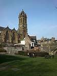 | |||
| High Street, Sheriff Court House, Former County Hall | 55°39′05″N 3°11′33″W | Category B | 39185 | | |||
| 46 And 48 High Street | 55°39′07″N 3°11′27″W | Category C(S) | 39202 | | |||
| Innerleithen Road, Glentrees, With Boundary Walls | 55°39′04″N 3°10′46″W | Category B | 39212 | | |||
| Innerleithen Road, Peebles Hotel Hydro, With Terracing | 55°39′09″N 3°10′38″W | Category B | 39220 | | |||
| Innerleithen Road, The White Stone And Wall | 55°39′04″N 3°10′55″W | Category B | 39223 | | |||
| 45 And 47 March Street, Gregory Place, With Boundary Walls | 55°39′16″N 3°11′44″W | Category C(S) | 39233 | | |||
| Rosetta, Walled Garden And Garden Building | 55°39′35″N 3°12′13″W | Category C(S) | 15210 | | |||
| Standalane Cottage | 55°39′44″N 3°12′09″W | Category C(S) | 48932 | | |||
| Old Town, Hay Lodge, With Boundary Walls | 55°39′05″N 3°11′52″W | Category B | 39245 | | |||
| 1 Rosetta Road, Viewfield, With Boundary Walls | 55°39′12″N 3°11′47″W | Category C(S) | 39259 | | |||
| 8 Springhill Road, Rydale | 55°38′56″N 3°11′27″W | Category C(S) | 39271 | | |||
| Springwood Drive, Springwood House | 55°38′49″N 3°11′29″W | Category C(S) | 39274 | | |||
| Tweed Green And School Brae, Grammar School With Gate | 55°39′03″N 3°11′21″W | Category B | 39281 | | |||
| 8 Cross Road With Boundary Walls, Gatepiers And Gates | 55°39′14″N 3°11′33″W | Category C(S) | 39156 | | |||
| Eastgate And Venlaw Road, Green Tree Inn | 55°39′08″N 3°11′14″W | Category C(S) | 39166 | | |||
| Edderston Road, Tantah | 55°38′24″N 3°11′54″W | Category B | 39170 | | |||
| Frankscroft, Borrowlea | 55°38′53″N 3°11′46″W | Category C(S) | 39176 | | |||
| Frankscroft, Maryfield | 55°38′51″N 3°11′45″W | Category C(S) | 39177 | | |||
| High Street, Chambers Institution | 55°39′06″N 3°11′21″W | Category A | 39180 | .jpg) | |||
| High Street, Telephone Kiosk Outside County Hotel | 55°39′06″N 3°11′25″W | Category B | 39186 | | |||
| High Street, Tontine Hotel | 55°39′04″N 3°11′26″W | Category B | 39187 | | |||
| High Street, Town House | 55°39′05″N 3°11′23″W | Category A | 39188 | | |||
| 49 High Street | 55°39′05″N 3°11′28″W | Category C(S) | 39194 | | |||
| 75 And 77 High Street | 55°39′04″N 3°11′32″W | Category B | 39197 | | |||
| 60 High Street | 55°39′06″N 3°11′28″W | Category C(S) | 39206 | | |||
| Innerleithen Road, Venbrae And Ravensmeade, With Boundary Walls | 55°39′04″N 3°10′50″W | Category C(S) | 39222 | | |||
| Kingsmeadows Road, St. Peter's Old Rectory With Boundary Walls And Gatepiers | 55°38′56″N 3°11′19″W | Category B | 39227 | | |||
| 36 Biggiesknowe, Red Lion House, With Boundary Wall | 55°39′10″N 3°11′28″W | Category B | 39143 | | |||
| Bonnington Road, Kingsmuir Lodge With Quadrant Walls | 55°38′42″N 3°11′22″W | Category C(S) | 39147 | | |||
| Old Town, St Andrew's Cemetery With Boundary Wall, Gatepiers, Gates And Railings | 55°39′12″N 3°12′00″W | Category C(S) | 39249 | | |||
| 53 Old Town | 55°39′07″N 3°11′46″W | Category C(S) | 39252 | | |||
| 5 St Andrews Place | 55°39′13″N 3°11′53″W | Category C(S) | 39263 | | |||
| Springhill Road, Elderscroft With Boundary Walls, Gatepiers, Gates And Railings | 55°38′51″N 3°11′22″W | Category C(S) | 39267 | | |||
| Tweed Avenue, Priorsford House And Lodge With Boundary Walls And Gatepiers | 55°39′00″N 3°11′13″W | Category C(S) | 39277 | | |||
| Cross Road, Remains Of The Cross Kirk With Boundary Walls | 55°39′15″N 3°11′33″W | Category A | 39155 | .jpg) | |||
| 5 Damdale With Front Wall And Gate | 55°39′15″N 3°11′29″W | Category C(S) | 39162 | | |||
| Eastgate, Eastgate Theatre And Arts Centre, Former Free Church | 55°39′09″N 3°11′15″W | Category B | 39165 | | |||
| High Street, County Hotel | 55°39′05″N 3°11′25″W | Category B | 39182 | | |||
| 22 And 24 High Street | 55°39′07″N 3°11′24″W | Category C(S) | 39200 | | |||
| 84 And 86 High Street | 55°39′06″N 3°11′31″W | Category C(S) | 39210 | | |||
| Innerleithen Road, Kerfield East Lodge | 55°38′59″N 3°10′23″W | Category C(S) | 39214 | | |||
| Innerleithen Road, Whitestone House With Boundary Walls | 55°39′04″N 3°10′58″W | Category C(S) | 39225 | | |||
| Bonnington Road, Kingswood Lodge With Boundary Walls | 55°38′42″N 3°11′21″W | Category C(S) | 39148 | | |||
| Rosetta Stables | 55°39′38″N 3°12′14″W | Category B | 19728 | | |||
| Whitehaugh Farm | 55°38′23″N 3°10′18″W | Category B | 15216 | | |||
| Rosetta, Lodge And Gatepiers | 55°39′32″N 3°11′57″W | Category C(S) | 48930 | |
Key
The scheme for classifying buildings in Scotland is:
- Category A: "buildings of national or international importance, either architectural or historic; or fine, little-altered examples of some particular period, style or building type."[1]
- Category B: "buildings of regional or more than local importance; or major examples of some particular period, style or building type, which may have been altered."[1]
- Category C: "buildings of local importance; lesser examples of any period, style, or building type, as originally constructed or moderately altered; and simple traditional buildings which group well with other listed buildings."[1]
In March 2016 there were 47,288 listed buildings in Scotland. Of these, 8% were Category A, and 50% were Category B, with the remaining 42% being Category C.[2]
Notes
- Sometimes known as OSGB36, the grid reference (where provided) is based on the British national grid reference system used by the Ordnance Survey.
• "Guide to National Grid". Ordnance Survey. Retrieved 12 December 2007.
• "Get-a-map". Ordnance Survey. Retrieved 17 December 2007. - Historic Environment Scotland assign a unique alphanumeric identifier to each designated site in Scotland, for listed buildings this always begins with "LB", for example "LB12345".
gollark: It's not. I'm lying. Conditionals do not exist.
gollark: `if x then y else z end`
gollark: It doesn't actually take pictures.
gollark: It works fine.
gollark: OR DID YOU?
References
- All entries, addresses and coordinates are based on data from Historic Scotland. This data falls under the Open Government Licence
- "What is Listing?". Historic Environment Scotland. Retrieved 29 May 2018.
- Scotland's Historic Environment Audit 2016 (PDF). Historic Environment Scotland and the Built Environment Forum Scotland. pp. 15–16. Retrieved 29 May 2018.
This article is issued from Wikipedia. The text is licensed under Creative Commons - Attribution - Sharealike. Additional terms may apply for the media files.