List of listed buildings in Chirnside, Scottish Borders
List
| Name | Location | Date Listed | Grid Ref. [note 1] | Geo-coordinates | Notes | LB Number [note 2] | Image |
|---|---|---|---|---|---|---|---|
| Ninewells Dovecot | 55°47′55″N 2°12′32″W | Category A | 4124 |  | |||
| Chirnside, Kirkgate, The Old Manse, Formerly Glebe House | 55°47′56″N 2°12′40″W | Category B | 178 | | |||
| Blackburn Farm, Former Farm Cottages (Derelict) | 55°49′18″N 2°10′48″W | Category C(S) | 46339 | | |||
| Chirnside, Main Street East End, Leaside | 55°48′09″N 2°12′30″W | Category C(S) | 46347 | | |||
| Chirnside, Waterloo Arms Hotel | 55°47′48″N 2°12′38″W | Category C(S) | 46352 | | |||
| Maines Farmhouse Including Boundary Walls | 55°48′08″N 2°11′32″W | Category C(S) | 46359 | | |||
| Maines South Lodge Including Boundary Wall | 55°48′02″N 2°11′16″W | Category C(S) | 46361 | | |||
| Whitehall Stables | 55°47′20″N 2°12′05″W | Category B | 46363 | | |||
| Whitehall Dovecot | 55°47′25″N 2°12′16″W | Category B | 181 | | |||
| Chirnside, Kirkgate, Braemar | 55°47′51″N 2°12′38″W | Category C(S) | 46344 | | |||
| 1-4 (Inclusive Nos) Edington Mill Cottages | 55°47′15″N 2°10′23″W | Category C(S) | 46357 | | |||
| Ninewells Walled Garden | 55°47′35″N 2°12′51″W | Category C(S) | 46362 | | |||
| Chirnside, Chirnside Primary School Including Playsheds, Boundary Walls, Quadrant Walls, Gates And Gatepiers | 55°47′53″N 2°12′25″W | Category A | 6620 | 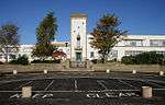 | |||
| Chirnside, 2 Kirkgate (To N Of Kirkgate Cottage) Including Post Box | 55°47′50″N 2°12′37″W | Category C(S) | 46343 | | |||
| Chirnside, Main Street East End, Smithy House | 55°48′12″N 2°11′55″W | Category C(S) | 46349 | | |||
| Chirnside, Main Street West End, Elm Bank (Former Ninewells School And School House) Including Ancillary Structure, Boundary Wall, Gatepiers And Gate | 55°48′03″N 2°13′06″W | Category C(S) | 46351 | | |||
| Chirnside Station (Former) | 55°48′15″N 2°14′14″W | Category C(S) | 46355 | | |||
| Edington Mill (Former) Including Bridge, Lade And Cauld | 55°47′14″N 2°10′14″W | Category B | 6581 | | |||
| Chirnside, Kirkgate, The Old Bakery Including Bakery Building, Ancillary Structure, Boundary Walls, Railings And Gates | 55°47′52″N 2°12′37″W | Category B | 46345 | | |||
| Chirnside, Main Street East End, Field House Including Ancillary Wing And Boundary Wall | 55°48′11″N 2°12′01″W | Category C(S) | 46346 | | |||
| Chirnside, Waterloo Cottage Including Boundary Wall | 55°47′48″N 2°12′37″W | Category C(S) | 46353 | | |||
| Edington Mill Cottage Including Garden Walls And Railings | 55°47′15″N 2°10′24″W | Category C(S) | 46356 | | |||
| Harelaw Farm Steading | 55°48′45″N 2°11′59″W | Category C(S) | 46358 | | |||
| Edington Mains Farmhouse Including Ancillary Structure, Boundary Walls And Gatepiers | 55°47′35″N 2°09′56″W | Category B | 4125 | | |||
| Whitehall House Including Ancillary Structure (Former Gas House), Walled Garden And Gatepiers | 55°47′18″N 2°12′12″W | Category B | 180 | | |||
| Chirnside, Crosshill, Chirnside Community Centre (Former Chirnside North Church) Including Ancillary Block And Boundary Wall | 55°48′08″N 2°12′33″W | Category C(S) | 46340 | | |||
| Chirnside, Crosshill, Jesmond Cottage Including Boundary Walls And Gatepiers | 55°50′33″N 2°07′26″W | Category C(S) | 46341 | | |||
| Chirnside Hall Hotel, Formerly Maines House, Including Ancillary Structures, Iron Railings, Courtyard Wall And Gatepiers | 55°48′12″N 2°11′15″W | Category B | 46354 | | |||
| Maines House Walled Garden Including Greenhouses, Gatepiers And Gates | 55°48′15″N 2°11′11″W | Category B | 46360 | | |||
| Chirnside, Herbert Villa Including Boundary Wall | 55°47′50″N 2°12′41″W | Category C(S) | 46342 | | |||
| Chirnside, Main Street West End, Crofts House Including Garage And Boundary Walls | 55°48′08″N 2°12′42″W | Category C(S) | 46350 | | |||
| Chirnside, Main Street East End, Lochiel Including Boundary Walls, Piers And Gatepiers | 55°48′09″N 2°12′27″W | Category C(S) | 46348 | | |||
| Chirnside, Kirkgate, Chirnside Parish Church (Church Of Scotland) Including Graveyard, Mort-House, War Memorial, Boundary Walls, Gatepiers, Quadrant Walls, Memorial Gateway And Gates | 55°47′51″N 2°12′34″W | Category B | 4122 | | |||
| Chirnside, Kirkgate, Brewery House Including Ancillary Structure, Cobbled Courtyard, Boundary Walls, Gatepiers And Gate | 55°47′50″N 2°12′39″W | Category B | 4123 | |
Key
The scheme for classifying buildings in Scotland is:
- Category A: "buildings of national or international importance, either architectural or historic; or fine, little-altered examples of some particular period, style or building type."[1]
- Category B: "buildings of regional or more than local importance; or major examples of some particular period, style or building type, which may have been altered."[1]
- Category C: "buildings of local importance; lesser examples of any period, style, or building type, as originally constructed or moderately altered; and simple traditional buildings which group well with other listed buildings."[1]
In March 2016 there were 47,288 listed buildings in Scotland. Of these, 8% were Category A, and 50% were Category B, with the remaining 42% being Category C.[2]
Notes
- Sometimes known as OSGB36, the grid reference (where provided) is based on the British national grid reference system used by the Ordnance Survey.
• "Guide to National Grid". Ordnance Survey. Retrieved 2007-12-12.
• "Get-a-map". Ordnance Survey. Retrieved 2007-12-17. - Historic Environment Scotland assign a unique alphanumeric identifier to each designated site in Scotland, for listed buildings this always begins with "LB", for example "LB12345".
gollark: The API should probably be designed so that it provides individual cryptographic primitives for more advanced use but has simpler functions with sensible defaults for the really common things.
gollark: Eh, maybe. But if it's a convenient single-module minified library you can include it easily.
gollark: That's probably enough for most usecases.
gollark: I'm thinking:- SHA256- some somewhat sensible password hashing function- ChaCha20/AES256- ECC stuff
gollark: Yes. People often ask "how do I do [some crypto operation]" so just point them to it.
References
- All entries, addresses and coordinates are based on data from Historic Scotland. This data falls under the Open Government Licence
- "What is Listing?". Historic Environment Scotland. Retrieved 29 May 2018.
- Scotland's Historic Environment Audit 2016 (PDF). Historic Environment Scotland and the Built Environment Forum Scotland. pp. 15–16. Retrieved 29 May 2018.
This article is issued from Wikipedia. The text is licensed under Creative Commons - Attribution - Sharealike. Additional terms may apply for the media files.