List of listed buildings in Foulden, Scottish Borders
List
| Name | Location | Date Listed | Grid Ref. [note 1] | Geo-coordinates | Notes | LB Number [note 2] | Image |
|---|---|---|---|---|---|---|---|
| 37A Foulden Village Including Cobbled Walkway | 55°47′45″N 2°07′05″W | Category C(S) | 46573 |  | |||
| West Foulden Farm, Cartshed And Granary | 55°47′44″N 2°08′44″W | Category C(S) | 46584 | | |||
| Foulden Tithe Barn Including Cobbled Yard And Boundary Walls | 55°47′44″N 2°06′42″W | Category A | 10510 | 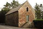 | |||
| Nunlands House Including Ancillary Structures, Boundary Walls, Gatepiers And Quadrant Walls | 55°48′02″N 2°06′20″W | Category B | 10511 | | |||
| Moorpark Farmhouse Or 25 Moorpark | 55°48′38″N 2°07′40″W | Category C(S) | 46583 | | |||
| Foulden Church (Church Of Scotland) Including Graveyard, Boundary Walls, Gatepiers, Gates And Mounting Stone | 55°47′43″N 2°06′42″W | Category B | 10485 | | |||
| Church House (Former Manse) Including Ancillary Structure, Boundary Walls, Gatepiers And Gate | 55°47′42″N 2°06′45″W | Category B | 10486 | | |||
| 16 Foulden Village | 55°47′44″N 2°06′58″W | Category B | 46574 | | |||
| Foulden Village, War Memorial | 55°47′44″N 2°07′06″W | Category C(S) | 46582 | | |||
| 11 And 12 Foulden Holdings | 55°47′56″N 2°07′29″W | Category C(S) | 46570 | | |||
| Foulden Village, Bankhill, Drumoyne And The Old Schoolhouse Including Boundary Wall | 55°47′45″N 2°07′07″W | Category B | 46575 | | |||
| Foulden Village, Mansefield | 55°47′44″N 2°06′57″W | Category B | 46578 | | |||
| 37 Foulden Village Including Cobbled Walkway | 55°47′44″N 2°07′04″W | Category C(S) | 13644 | | |||
| Foulden Village, Cheviot View | 55°47′44″N 2°06′56″W | Category B | 46577 | | |||
| Foulden Village, Rose Cottage Including Cobbled Walkway | 55°47′44″N 2°07′03″W | Category C(S) | 46579 | | |||
| Foulden Village, Thistle Cottage Including Ancillary Structure And Boundary Walls | 55°47′46″N 2°07′08″W | Category C(S) | 46580 | | |||
| Foulden Village, Wallflower Cottage Including Cobbled Walkway | 55°47′45″N 2°07′06″W | Category C(S) | 46581 | |
Key
The scheme for classifying buildings in Scotland is:
- Category A: "buildings of national or international importance, either architectural or historic; or fine, little-altered examples of some particular period, style or building type."[1]
- Category B: "buildings of regional or more than local importance; or major examples of some particular period, style or building type, which may have been altered."[1]
- Category C: "buildings of local importance; lesser examples of any period, style, or building type, as originally constructed or moderately altered; and simple traditional buildings which group well with other listed buildings."[1]
In March 2016 there were 47,288 listed buildings in Scotland. Of these, 8% were Category A, and 50% were Category B, with the remaining 42% being Category C.[2]
Notes
- Sometimes known as OSGB36, the grid reference (where provided) is based on the British national grid reference system used by the Ordnance Survey.
• "Guide to National Grid". Ordnance Survey. Retrieved 2007-12-12.
• "Get-a-map". Ordnance Survey. Retrieved 2007-12-17. - Historic Environment Scotland assign a unique alphanumeric identifier to each designated site in Scotland, for listed buildings this always begins with "LB", for example "LB12345".
gollark: Bee you. I said bees.
gollark: I could make it autoreconnect, although it can't detect mysterious silences.
gollark: What if you use the direct link in VLC or something?
gollark: It might be a poor connection to it, but 128kbps is basically nothing.
gollark: This even counts as a listener for OIR™.
References
- All entries, addresses and coordinates are based on data from Historic Scotland. This data falls under the Open Government Licence
- "What is Listing?". Historic Environment Scotland. Retrieved 29 May 2018.
- Scotland's Historic Environment Audit 2016 (PDF). Historic Environment Scotland and the Built Environment Forum Scotland. pp. 15–16. Retrieved 29 May 2018.
This article is issued from Wikipedia. The text is licensed under Creative Commons - Attribution - Sharealike. Additional terms may apply for the media files.