List of listed buildings in Eccles, Scottish Borders
List
| Name | Location | Date Listed | Grid Ref. [note 1] | Geo-coordinates | Notes | LB Number [note 2] | Image |
|---|---|---|---|---|---|---|---|
| Belchester, Walled Garden Including Greenhouse, Garden Seat, Sundial And Potting Shed | 55°41′01″N 2°19′46″W | Category C(S) | 45863 |  | |||
| Birgham, Springhill Gardener's Cottage And Former Stable Range Including Cobbled Courtyard | 55°38′33″N 2°20′34″W | Category C(S) | 45866 | | |||
| The Braw Bothy, Stablegate Cottage And Stables, (Formerly To Eccles House), Including Cobbled Path, Ancillary Structures, Boundary Wall, Quadrant Walls And Gatepiers | 55°39′51″N 2°22′33″W | Category B | 45867 | | |||
| Eccles House Including Service Wing, Ancillary Structures, Summer House, Boundary Walls, Quadrant Walls, Piers, Gatepiers And Gates | 55°39′48″N 2°22′37″W | Category B | 45872 | | |||
| Eccles Tofts Farmhouse Including Garden Walls, Quadrant Walls, Piers And Gatepiers | 55°41′56″N 2°23′23″W | Category B | 45879 | | |||
| Harlaw Farmhouse | 55°39′26″N 2°24′25″W | Category B | 45880 | | |||
| Springwells Old Farmhouse Including Garden Wall | 55°41′07″N 2°22′22″W | Category C(S) | 45903 | | |||
| Stainrigg House Including Stables, Little Stainrigg (Former Groom's Cottage), Kennels, Cobbled Courtyard, Courtyard Walls And Gatepiers | 55°41′11″N 2°20′59″W | Category B | 45905 | | |||
| Eccles House, St Mary's Convent (Remains Of) | 55°39′52″N 2°22′39″W | Category C(S) | 4077 | | |||
| Kames Stables Including Cobbled Courtyard To Front And Ancillary Structures (Further Stable Range And Barn With Hayloft) To Rear | 55°42′06″N 2°20′59″W | Category B | 4116 | | |||
| Belchester, Stable Block Including Groom's Cottage, Ancillary Structures, Courtyard Walls And Gatepiers | 55°41′08″N 2°19′41″W | Category B | 45862 | | |||
| Bughtrig, West Lodge Including Entrance Walls, Piers And Gatepiers | 55°41′40″N 2°19′38″W | Category C(S) | 45869 | | |||
| Eccles, Glebe House (Former Manse) Including Stables, Boundary Walls, Quadrant Walls And Gatepiers | 55°40′04″N 2°22′23″W | Category B | 45871 | | |||
| Eccles House, Walled Garden Including Greenhouses | 55°39′53″N 2°22′44″W | Category C(S) | 45874 | | |||
| Langrig Farmhouse | 55°42′00″N 2°18′49″W | Category C(S) | 45887 | | |||
| Loanknowe Farmhouse Including Boundary Walls, Mounting Stone, Gatepiers And Gate | 55°39′59″N 2°24′15″W | Category B | 45895 | | |||
| Mersington House Including Stable Block, Garden Walls, Boundary Walls, Quadrant Walls And Gatepiers | 55°41′29″N 2°21′31″W | Category B | 45897 | | |||
| Ploughlands | 55°41′19″N 2°23′20″W | Category C(S) | 45900 | | |||
| Stainrigg, April Cottage | 55°41′15″N 2°20′52″W | Category C(S) | 45904 | | |||
| West Printonan, Threshing Barn And Cartshed And Granary | 55°42′33″N 2°20′58″W | Category B | 45910 | | |||
| Anton's Hill House | 55°41′02″N 2°20′34″W | Category B | 6639 | | |||
| Eccles Church (Church Of Scotland) Including Graveyard, Mounting Stone, Boundary Walls And Gatepiers | 55°39′53″N 2°22′37″W | Category B | 4076 | | |||
| Anton's Hill, Quadrant Walls, Outer Walls And Piers Adjacent To North Lodge | 55°41′10″N 2°20′43″W | Category C(S) | 45859 | | |||
| Birgham, Hollybrae, Including Boundary Walls, Gatepiers And Gates | 55°38′38″N 2°20′14″W | Category C(S) | 45865 | | |||
| Bughtrig, Wood Cottage Including Ancillary Structure | 55°41′50″N 2°19′32″W | Category C(S) | 45870 | | |||
| Eccles Main Street, Eccles Mains Farmhouse Including Boundary Wall | 55°39′59″N 2°22′38″W | Category C(S) | 45877 | | |||
| Eccles Newton Farmhouse Including Garden Railings, Walls And Gatepier | 55°39′29″N 2°21′25″W | Category B | 45878 | | |||
| Kames Cottages | 55°42′04″N 2°21′02″W | Category C(S) | 45882 | | |||
| Leitholm, Church Lane, Leitholm Church (Church Of Scotland) | 55°41′25″N 2°20′06″W | Category C(S) | 45888 | | |||
| Leitholm, Main Street, Bughtrig Cottage | 55°41′31″N 2°19′55″W | Category C(S) | 45892 | | |||
| Stainrigg, Well | 55°41′12″N 2°20′48″W | Category C(S) | 45907 | | |||
| Bughtrig House | 55°41′46″N 2°19′34″W | Category A | 4114 | 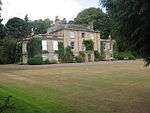 | |||
| West Leitholm Bridge, Crossing Lamden Burn | 55°41′20″N 2°20′25″W | Category B | 211 | | |||
| Eccles House, Lodge | 55°39′53″N 2°22′52″W | Category C(S) | 45873 | | |||
| Homebank House | 55°38′59″N 2°18′59″W | Category B | 45881 | | |||
| Kames Walled Garden | 55°42′02″N 2°20′58″W | Category B | 45884 | | |||
| Leitholm, Main Street, Well Cottage | 55°41′26″N 2°20′06″W | Category C(S) | 45894 | | |||
| Stonefold Farmhouse Including Garden Walls, Gatepiers And Gates | 55°40′31″N 2°24′40″W | Category C(S) | 45908 | | |||
| Eccles Main Street, Village Hall (Former Free Church) Including Boundary Walls | 55°39′57″N 2°22′38″W | Category C(S) | 45876 | | |||
| 1 And 2 Kames West Mains Farm Cottages | 55°41′42″N 2°20′52″W | Category C(S) | 45886 | | |||
| Leitholm, Main Street, Mansfield House Including Garden Walls | 55°41′22″N 2°20′20″W | Category C(S) | 45889 | | |||
| Leitholm, Main Street, Braehead Cottage Including Boundary Wall | 55°41′23″N 2°20′19″W | Category C(S) | 45890 | | |||
| Leitholm, Main Street, Earnslaw House Including Boundary Wall, Railings And Gates | 55°41′27″N 2°20′07″W | Category C(S) | 45891 | | |||
| Leitholm, Main Street, The Plough Hotel Including Cobbled Forecourt | 55°41′25″N 2°20′10″W | Category C(S) | 45893 | | |||
| Pittlesheugh Farmhouse Including Garden Walls | 55°40′56″N 2°23′32″W | Category C(S) | 45899 | | |||
| Kames House Including Cobbled Courtyard | 55°42′08″N 2°20′51″W | Category A | 4115 | | |||
| Bartlehill Farmhouse | 55°39′25″N 2°21′51″W | Category C(S) | 45860 | | |||
| Lochrig Farmhouse | 55°42′20″N 2°19′43″W | Category C(S) | 45896 | | |||
| Mersington Mill Including Garden Walls | 55°41′37″N 2°22′07″W | Category C(S) | 45898 | | |||
| Purves Hall (House) Including Entrance Wall | 55°41′49″N 2°22′52″W | Category C(S) | 45901 | | |||
| Purves Hall, Walled Garden | 55°41′51″N 2°22′54″W | Category C(S) | 45902 | | |||
| West Printonan Farmhouse Including Ancillary Structure And Garden Walls | 55°42′35″N 2°20′56″W | Category B | 45909 | | |||
| Belchester Including Terraced Garden, Sundial, Garden Railings, Gatepiers And Gate | 55°41′05″N 2°19′41″W | Category B | 4113 | | |||
| Birgham, Springhill House Including Dovecot, Well, Quadrant Walls, Gatepiers And Gates | 55°38′33″N 2°20′30″W | Category B | 4117 | | |||
| Bughtrig, East Lodge Including Entrance Walls And Gatepiers | 55°41′45″N 2°19′24″W | Category C(S) | 213 | | |||
| Belchester Lodge Including Quadrant Walls, Piers, Gatepiers And Gates | 55°40′51″N 2°20′04″W | Category C(S) | 45861 | | |||
| Birgham, Dub Cottage | 55°38′27″N 2°20′47″W | Category C(S) | 45864 | | |||
| Bridge, Near Mersington House, Crossing Lambden Burn | 55°41′28″N 2°21′45″W | Category B | 45868 | | |||
| 23 Eccles Main Street, East Lodge (Formerly To Eccles House) Including Gatepiers | 55°39′55″N 2°22′43″W | Category C(S) | 45875 | | |||
| Kames North Entrance | 55°42′24″N 2°21′24″W | Category C(S) | 45883 | | |||
| Kames West Lodge Including Cobbled Forecourt, Quadrant Walls, Piers, Gatepiers And Gates | 55°42′05″N 2°21′23″W | Category C(S) | 45885 | | |||
| Stainrigg, Walled Garden Including Potting Shed, Outer Garden Walls And Railings | 55°41′12″N 2°20′56″W | Category C(S) | 45906 | | |||
| Purves Hall (Tower) | 55°41′50″N 2°22′55″W | Category B | 4144 | | |||
| Anton's Hill, East Lodge Including Gatepiers And Gate | 55°41′08″N 2°20′21″W | Category C(S) | 45858 | |
Key
The scheme for classifying buildings in Scotland is:
- Category A: "buildings of national or international importance, either architectural or historic; or fine, little-altered examples of some particular period, style or building type."[1]
- Category B: "buildings of regional or more than local importance; or major examples of some particular period, style or building type, which may have been altered."[1]
- Category C: "buildings of local importance; lesser examples of any period, style, or building type, as originally constructed or moderately altered; and simple traditional buildings which group well with other listed buildings."[1]
In March 2016 there were 47,288 listed buildings in Scotland. Of these, 8% were Category A, and 50% were Category B, with the remaining 42% being Category C.[2]
Notes
- Sometimes known as OSGB36, the grid reference (where provided) is based on the British national grid reference system used by the Ordnance Survey.
• "Guide to National Grid". Ordnance Survey. Retrieved 2007-12-12.
• "Get-a-map". Ordnance Survey. Retrieved 2007-12-17. - Historic Environment Scotland assign a unique alphanumeric identifier to each designated site in Scotland, for listed buildings this always begins with "LB", for example "LB12345".
gollark: At last.
gollark: ddg! macron deletion.
gollark: Because it's Tuesday.
gollark: Apioforms have propagated to several other servers.
gollark: After that there are gaps in the sequence.
References
- All entries, addresses and coordinates are based on data from Historic Scotland. This data falls under the Open Government Licence
- "What is Listing?". Historic Environment Scotland. Retrieved 29 May 2018.
- Scotland's Historic Environment Audit 2016 (PDF). Historic Environment Scotland and the Built Environment Forum Scotland. pp. 15–16. Retrieved 29 May 2018.
This article is issued from Wikipedia. The text is licensed under Creative Commons - Attribution - Sharealike. Additional terms may apply for the media files.