List of listed buildings in Coldingham, Scottish Borders
List
| Name | Location | Date Listed | Grid Ref. [note 1] | Geo-coordinates | Notes | LB Number [note 2] | Image |
|---|---|---|---|---|---|---|---|
| Coldingham, Coldingham Priory (Church Of Scotland) Including Transept Arch, Former Hearse House And Gravedigger's Store, Graveyard, Boundary Walls, Gatepiers And Gates | 55°53′12″N 2°09′23″W | Category A | 4059 | 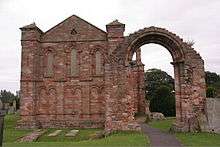 | |||
| Press Castle, Dovecot | 55°52′53″N 2°12′27″W | Category B | 4102 |  | |||
| St Abb's Head, Lighthouse Including Foghorn, Foghorn Engine House, Boundary Walls And Stair | 55°54′59″N 2°08′18″W | Category B | 4103 | | |||
| Coldingham, Paradise, Glencourt Including Garden Walls | 55°53′10″N 2°09′29″W | Category C(S) | 62 | | |||
| Auchencrow, The Craw Inn | 55°50′21″N 2°14′13″W | Category C(S) | 46593 | | |||
| Butterdean Farmhouse Including Ancillary Structures, Walled Garden, Boundary Walls And Gatepiers | 55°52′30″N 2°19′23″W | Category C(S) | 46594 | | |||
| Coldingham, Eyemouth Road, Bonardub Including Ancillary Structure And Gatepiers | 55°53′04″N 2°09′18″W | Category C(S) | 46602 | | |||
| Coldingham, Law House | 55°53′03″N 2°08′55″W | Category C(S) | 46607 | | |||
| Coldingham, School Road, Courtburn House Including Ancillary Structure, Boundary Walls, Gatepiers And Gates | 55°53′14″N 2°09′34″W | Category C(S) | 46613 | | |||
| Grantshouse, Honbu Cottage | 55°53′00″N 2°17′46″W | Category B | 46626 | | |||
| Greenburn Farmhouse Including Garden Walls | 55°50′19″N 2°15′33″W | Category C(S) | 46628 | | |||
| Reston, Main Street, Cruachan Including Ancillary Structure, Boundary Walls, Railings And Gate | 55°51′08″N 2°11′26″W | Category C(S) | 46647 | | |||
| Reston, Main Street, St Mary's Villa And Culblean Including Ancillary Structure, Boundary Walls, Railings, Gatepiers And Gates | 55°51′09″N 2°11′33″W | Category C(S) | 46651 | | |||
| St Abb's Head, The Ranger's House And Office | 55°54′13″N 2°08′38″W | Category C(S) | 46663 | | |||
| Shawbraes Farmhouse Including Garden Walls | 55°51′18″N 2°13′07″W | Category B | 46664 | | |||
| Coldingham, Bogan, Holmleigh | 55°53′17″N 2°09′23″W | Category C(S) | 43376 | | |||
| Coldingham, Bogangreen House Including Stable Block, Walled Garden, Boundary Walls, Quadrant Walls And Gatepiers | 55°53′20″N 2°09′42″W | Category B | 6578 | | |||
| Renton House Including Pavilions, Sundial, Quadrant Walls And Boundary Walls | 55°52′51″N 2°17′05″W | Category A | 4105 | .jpg) | |||
| Houndwood, Houndwood Church (Church Of Scotland) Including Graveyard, Boundary Walls | 55°52′03″N 2°15′06″W | Category B | 4107 | | |||
| Coldingham, The Bow, Burnlea, Including Boundary Walls | 55°53′09″N 2°09′20″W | Category C(S) | 46596 | | |||
| Coldingham, Bridge Street, Abbey Cottage Including Boundary Walls And Gate | 55°53′09″N 2°09′29″W | Category B | 46597 | | |||
| Coldingham, Fisher's Brae, Hill View Including Garden Walls And Piers | 55°53′17″N 2°09′15″W | Category C(S) | 46604 | | |||
| Coldingham School Road, Sunnybank Including Ancillary Structure And Boundary Walls | 55°53′14″N 2°09′36″W | Category B | 46615 | | |||
| Hillend Farm Steading Including Cobbled Yard | 55°51′55″N 2°12′54″W | Category B | 46630 | | |||
| St Abbs, St Abbs Church (Church Of Scotland) Including Boundary Walls And Railings | 55°53′58″N 2°08′02″W | Category C(S) | 46660 | | |||
| St Abb's Head, Lightkeeper's Cottage, Lighthouse Retreat And Keeper's Hold Including Boundary Walls And Gatepiers | 55°54′57″N 2°08′22″W | Category C(S) | 46662 | | |||
| Houndwood House Including Garden Bridges To N And W | 55°51′36″N 2°14′06″W | Category B | 4098 | | |||
| Alemill Farmhouse Including Boundary Walls | 55°51′55″N 2°08′21″W | Category C(S) | 46585 | | |||
| Cairncross Farmhouse Including Boundary Walls, Gatepiers, Gate And Railings | 55°51′55″N 2°10′28″W | Category C(S) | 46595 | | |||
| Coldingham, Bridge Street, Bridge Spanning St Andrew's Burn | 55°53′09″N 2°09′27″W | Category C(S) | 46598 | | |||
| Coldingham, Christison's Brae, Gracehurst | 55°53′16″N 2°09′23″W | Category C(S) | 46600 | | |||
| Coldingham, High Street, Fern Neuk Including Boundary Walls And Gate | 55°53′13″N 2°09′24″W | Category C(S) | 46606 | | |||
| Coldingham, School Road, Coldingham Primary School Including Boundary Walls And Railings | 55°53′18″N 2°09′43″W | Category C(S) | 46612 | | |||
| Fairlaw House Including Former Cartshed, Store, Ancillary Structure And Garden Walls | 55°50′43″N 2°13′52″W | Category B | 46622 | | |||
| Hallydown House Including Walled Garden And Boundary Walls | 55°52′29″N 2°07′22″W | Category B | 46629 | | |||
| Houndwood, Westwood House (Former Manse) Including Ancillary Structure, Boundary Walls And Gatepiers | 55°52′05″N 2°15′15″W | Category C(S) | 46637 | | |||
| Houndwood House, South Lodge | 55°51′30″N 2°14′08″W | Category C(S) | 46640 | | |||
| Reston, The Old School House Including Boundary Walls | 55°51′06″N 2°12′17″W | Category C(S) | 46653 | | |||
| St Abbs, Northfield House Including Turbine House (Former), Walled Garden, Railings, Boundary Walls And Entrance Gate | 55°54′01″N 2°08′06″W | Category B | 46658 | | |||
| Whitecross Farm, Cartshed And Granary | 55°52′35″N 2°08′57″W | Category C(S) | 46667 | | |||
| Press Castle Including Ancillary Range, Courtyard Wall, Boundary Walls, Quadrant Walls, Piers And Gatepiers | 55°52′54″N 2°12′28″W | Category B | 4101 | | |||
| St Abbs, Harbour And Old Fish Houses | 55°53′55″N 2°07′48″W | Category B | 4104 | | |||
| Sunnyside Farmhouse, Near Auchencrow, Including Garden Walls | 55°50′44″N 2°14′13″W | Category C(S) | 4106 | | |||
| Coldingham, Coldingham Public Hall | 55°53′12″N 2°09′24″W | Category C(S) | 46601 | | |||
| Coldingham, Law House Lodge | 55°53′00″N 2°09′03″W | Category C(S) | 46608 | | |||
| Coldingham, School Road, Barrie House Including Boundary Wall | 55°53′13″N 2°09′28″W | Category C(S) | 46610 | | |||
| Ferneycastle Farmhouse Including Ancillary Structure, Garden Walls And Gatepiers | 55°50′07″N 2°11′40″W | Category C(S) | 46623 | | |||
| Hillend Farmhouse Including Cobbled Courtyard And Garden Walls | 55°51′56″N 2°12′52″W | Category C(S) | 46635 | | |||
| Houndwood, The Rest | 55°51′56″N 2°14′48″W | Category C(S) | 46636 | | |||
| Howpark Farmhouse Including Garden Walls | 55°53′19″N 2°16′38″W | Category C(S) | 46642 | | |||
| Press Castle, Gate Lodge | 55°52′48″N 2°12′23″W | Category C(S) | 46643 | | |||
| Renton House, Walled Garden | 55°52′54″N 2°16′57″W | Category C(S) | 46645 | | |||
| Reston, Main Street, Reston Auction Mart, Sheep Ring | 55°51′06″N 2°11′25″W | Category B | 46648 | 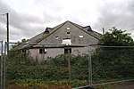 | |||
| St Abbs, Cyrus House | 55°53′55″N 2°07′46″W | Category C(S) | 46656 | | |||
| Reston, Main Street, March House Including Garden Walls | 55°51′09″N 2°11′37″W | Category C(S) | 191 | | |||
| Stoneshiel Hall, Former Dovecot, Ancillary Structure And Courtyard Walls | 55°50′08″N 2°12′22″W | Category C(S) | 193 | | |||
| Auchencrow, Cheviot View | 55°50′21″N 2°14′18″W | Category C(S) | 46586 | | |||
| Coldingham, Fisher's Brae, Teviot House | 55°53′17″N 2°09′15″W | Category C(S) | 46605 | | |||
| Coldingham, School Road, The Anchor Inn | 55°53′13″N 2°09′27″W | Category C(S) | 46609 | | |||
| Grantshouse, Eye View Including Garden Wall | 55°52′59″N 2°18′20″W | Category C(S) | 46624 | | |||
| Houndwood House, Bridge To Sw House | 55°51′31″N 2°14′09″W | Category C(S) | 46639 | | |||
| Reston, Reston Primary School Including Boundary Walls, Railings And Gates | 55°51′08″N 2°12′17″W | Category C(S) | 46654 | | |||
| St Abb's Head, Boat House At Mire Loch | 55°54′37″N 2°08′24″W | Category C(S) | 46661 | | |||
| Westloch House, Former Stable Block (Incorporating Former Chapel) Including Remains Of Walled Garden | 55°54′27″N 2°10′16″W | Category C(S) | 46666 | | |||
| Coldingham, The Bow, Benedict House (Former Parish Manse) Including Ancillary Structure, Garden Walls And Gatepiers | 55°53′12″N 2°09′12″W | Category B | 4095 | | |||
| Stoneshiel Hall Including Ancillary Structure, Boundary Walls, Gatepiers And Gates | 55°50′10″N 2°12′21″W | Category B | 4100 | | |||
| Coldingham, Bridge Street, The New Inn Including Courtyard Wall | 55°53′12″N 2°09′25″W | Category C(S) | 46599 | | |||
| Coldingham, School Road, Bromley House | 55°53′13″N 2°09′28″W | Category C(S) | 46611 | | |||
| Grantshouse, Ivy Bank And Ivy Bank Curios | 55°52′58″N 2°18′27″W | Category C(S) | 46627 | | |||
| Reston, Main Street, Reston House Including Boundary Walls, Railings, Gatepiers And Gate | 55°51′09″N 2°11′31″W | Category C(S) | 46649 | | |||
| Reston, Main Street, Reston Parish Church (Church Of Scotland) Including Boundary Walls | 55°51′07″N 2°11′45″W | Category C(S) | 46650 | | |||
| St Abbs, Rock House Including Ancillary Structure And Boundary Walls | 55°53′57″N 2°07′50″W | Category C(S) | 46659 | | |||
| Coldingham, School Road, Market Cross | 55°53′13″N 2°09′28″W | Category A | 4094 | 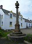 | |||
| Coldingham, School Road, The Barn Including Boundary Walls | 55°53′14″N 2°09′36″W | Category C(S) | 4097 | | |||
| Coldingham, Fisher's Brae, Burnbank Including Boundary Walls, Railings And Gates | 55°53′18″N 2°09′14″W | Category C(S) | 46603 | | |||
| Coldingham, School Road, Woodbine Cottage, Ancillary Structure / Workshop | 55°53′13″N 2°09′30″W | Category C(S) | 46616 | | |||
| Coldingham Loch, Boat House | 55°54′37″N 2°10′03″W | Category C(S) | 46620 | | |||
| Coldlands Farmhouse | 55°50′33″N 2°14′58″W | Category C(S) | 46621 | | |||
| Houndwood House, Walled Garden | 55°51′40″N 2°14′04″W | Category C(S) | 46641 | | |||
| Press Castle, Walled Garden | 55°52′52″N 2°12′29″W | Category C(S) | 46644 | | |||
| Reston, Mill Lade House | 55°51′22″N 2°12′50″W | Category C(S) | 46652 | | |||
| St Abbs, Castle Rock | 55°53′50″N 2°07′43″W | Category C(S) | 46655 | | |||
| St Abbs, Murrayfield, Cliff Cottage Including Garden Walls | 55°53′53″N 2°07′51″W | Category C(S) | 46657 | | |||
| Templehall Lodge | 55°53′02″N 2°10′10″W | Category C(S) | 46665 | | |||
| Coldingham, School Road, Crossgate House Including Ancillary Structures And Boundary Walls | 55°53′13″N 2°09′30″W | Category C(S) | 4096 | | |||
| Coldingham, Bridge Street, Post Office And Post Office House | 55°53′10″N 2°09′26″W | Category C(S) | 190 | | |||
| Coldingham, School Road, Robertson Memorial Hall Including Railings, Gatepiers And Gate | 55°53′11″N 2°09′29″W | Category C(S) | 46614 | | |||
| Coldingham, War Memorial Including Boundary Walls, Gatepiers And Gate | 55°53′13″N 2°09′25″W | Category C(S) | 46617 | | |||
| Grantshouse, Harelawside Farmhouse, Including Garden Walls | 55°53′05″N 2°17′49″W | Category C(S) | 46625 | | |||
| Renton School (Former) Including Boundary Walls | 55°52′26″N 2°17′04″W | Category C(S) | 46646 | |
Key
The scheme for classifying buildings in Scotland is:
- Category A: "buildings of national or international importance, either architectural or historic; or fine, little-altered examples of some particular period, style or building type."[1]
- Category B: "buildings of regional or more than local importance; or major examples of some particular period, style or building type, which may have been altered."[1]
- Category C: "buildings of local importance; lesser examples of any period, style, or building type, as originally constructed or moderately altered; and simple traditional buildings which group well with other listed buildings."[1]
In March 2016 there were 47,288 listed buildings in Scotland. Of these, 8% were Category A, and 50% were Category B, with the remaining 42% being Category C.[2]
Notes
- Sometimes known as OSGB36, the grid reference (where provided) is based on the British national grid reference system used by the Ordnance Survey.
• "Guide to National Grid". Ordnance Survey. Retrieved 2007-12-12.
• "Get-a-map". Ordnance Survey. Retrieved 2007-12-17. - Historic Environment Scotland assign a unique alphanumeric identifier to each designated site in Scotland, for listed buildings this always begins with "LB", for example "LB12345".
gollark: Did you know? GTech™ harbinges environmental devastation.
gollark: This inspires confidence in the book.
gollark: Hi.
gollark: Sorry, network issues meant weird desync.
gollark: According to 9 out of 9 dentists.
References
- All entries, addresses and coordinates are based on data from Historic Scotland. This data falls under the Open Government Licence
- "What is Listing?". Historic Environment Scotland. Retrieved 29 May 2018.
- Scotland's Historic Environment Audit 2016 (PDF). Historic Environment Scotland and the Built Environment Forum Scotland. pp. 15–16. Retrieved 29 May 2018.
This article is issued from Wikipedia. The text is licensed under Creative Commons - Attribution - Sharealike. Additional terms may apply for the media files.