List of listed buildings in Duns, Scottish Borders
List
| Name | Location | Date Listed | Grid Ref. [note 1] | Geo-coordinates | Notes | LB Number [note 2] | Image |
|---|---|---|---|---|---|---|---|
| Manderston, Buxley, Dairyman's House And Archway | 55°47′09″N 2°18′19″W | Category B | 42509 |  | |||
| Manderston, Lake Wood, Chinese Bridge | 55°46′49″N 2°18′11″W | Category B | 42523 | | |||
| Manderston Mains | 55°47′24″N 2°18′06″W | Category C(S) | 42524 | | |||
| Putton Mill, Cottages, Steading And Former Mill | 55°45′38″N 2°19′37″W | Category B | 42541 | | |||
| Brieryhill, Cottages | 55°46′49″N 2°17′36″W | Category B | 42477 | | |||
| Brieryhill, House, Kennels, Steading And Stalk | 55°46′48″N 2°17′37″W | Category B | 42478 | | |||
| Cockburn Mill And Outbuildings | 55°48′55″N 2°21′33″W | Category B | 42485 | | |||
| Duns Castle Estate, Stable Block | 55°46′58″N 2°21′23″W | Category B | 42497 | | |||
| 6 Church Square Parish Church Halls | 55°46′40″N 2°20′32″W | Category B | 26486 | | |||
| 1 Clouds With Former Gig House And Stable, And Boundary Wall | 55°46′45″N 2°20′47″W | Category B | 26487 | | |||
| 12 And 12A Currie Street With Gatepiers, Former Stable, And Hayloft | 55°46′39″N 2°20′27″W | Category B | 26498 | | |||
| 14 Langtongate | 55°46′37″N 2°20′51″W | Category C(S) | 26512 | | |||
| 36 And 37 Market Square (Northern Rock Building Society And Fpc&G Solicitors) | 55°46′39″N 2°20′40″W | Category B | 26530 | | |||
| 50 And 51 Market Square | 55°46′39″N 2°20′38″W | Category B | 26537 | | |||
| 56, 56A, B And C And 57 Market Square | 55°46′39″N 2°20′37″W | Category C(S) | 26538 | | |||
| 9 Murray Street With Wall | 55°46′39″N 2°20′34″W | Category C(S) | 26540 | | |||
| 14 And 16 Murray Street, Marchcroft And Adjoining House With Boundary Walls And Gatepiers | 55°46′37″N 2°20′35″W | Category B | 26546 | | |||
| 29 Newtown Street With Attached Barn And Stables To Rear, With Sundial | 55°46′41″N 2°20′47″W | Category B | 26550 | | |||
| 14 Newtown Street, County Offices With Gatepiers And Railings | 55°46′43″N 2°20′47″W | Category B | 26558 | | |||
| 30 Newtown Street | 55°46′41″N 2°20′52″W | Category C(S) | 26566 | | |||
| Preston Road Cemetery | 55°47′01″N 2°20′08″W | Category C(S) | 26573 | | |||
| Preston Road, Christ Church (Episcopal) With Steps, Boundary Wall, Gates, Lamp Standard And Burial Ground | 55°46′52″N 2°20′34″W | Category B | 26574 | | |||
| 1-7 (Odd Nos) South Street | 55°46′39″N 2°20′39″W | Category B | 26579 | | |||
| Station Road, Blyth Bank With Boundary Wall, Gatepiers And Gates | 55°46′33″N 2°20′25″W | Category B | 26589 | | |||
| Station Road, The Hermitage With Garage, Boundary Wall, Gatepiers And Gates | 55°46′27″N 2°20′29″W | Category B | 26590 | | |||
| Station Road, The Wellnage With Boundary Wall, Gatepiers And Gates | 55°46′31″N 2°20′23″W | Category B | 26596 | | |||
| 15 Tiendhillgreen With Conservatory, Boundary Wall And Gateway | 55°46′51″N 2°20′37″W | Category B | 26603 | | |||
| Bridgend, Lanark Lodge With Stable Buildings | 55°46′32″N 2°20′08″W | Category B | 26455 | | |||
| 10 Bridgend | 55°46′36″N 2°20′20″W | Category C(S) | 26460 | | |||
| 22 Bridgend With Boundary Wall And Gatepiers | 55°46′35″N 2°20′15″W | Category C(S) | 26461 | | |||
| Castle Street, Manse Gates And Barn | 55°46′45″N 2°20′42″W | Category C(S) | 26464 | | |||
| 19-23 (Inclusive Nos) Castle Street | 55°46′43″N 2°20′41″W | Category C(S) | 26467 | | |||
| 28 And 28B Castle Street | 55°46′43″N 2°20′39″W | Category C(S) | 26481 | | |||
| Grueldykes With Cottage, Garage, Boundary Walls And Gatepiers | 55°46′07″N 2°21′09″W | Category B | 4028 | | |||
| Manderston Buxley, Bullock Court And Implement Shed | 55°47′10″N 2°18′19″W | Category B | 4035 | | |||
| Manderston, North Entrance Gatepiers, Railings And Stalk | 55°47′08″N 2°18′27″W | Category B | 42526 | | |||
| Manderston Mill, House | 55°47′47″N 2°18′31″W | Category C(S) | 42527 | | |||
| Manderston, Pinkie Cottages And Pinkie Smithy | 55°46′34″N 2°18′31″W | Category C(S) | 42530 | | |||
| Manderston, Sunken Terraces With Pavilion And Dovecot | 55°46′58″N 2°18′08″W | Category B | 42533 | | |||
| Playfield | 55°47′28″N 2°19′41″W | Category C(S) | 42539 | | |||
| Chalkielaw Farmhouse, Steading And Stalk | 55°46′48″N 2°18′55″W | Category B | 42482 | | |||
| Duns Castle Estate, Gardener's Cottage | 55°46′50″N 2°21′48″W | Category C(S) | 42492 | | |||
| 4 And 5 Golden Square | 55°46′39″N 2°20′42″W | Category C(S) | 26504 | | |||
| 6, 6A And 7 Golden Square | 55°46′40″N 2°20′42″W | Category C(S) | 26505 | | |||
| 7 Langtongate | 55°46′37″N 2°20′50″W | Category C(S) | 26507 | | |||
| 11 And 12 Market Square, The Royal Bank Of Scotland | 55°46′41″N 2°20′36″W | Category B | 26521 | | |||
| 40 And 41 Market Square | 55°46′40″N 2°20′39″W | Category C(S) | 26532 | | |||
| 11 And 13 Newtown Street, Boston House | 55°46′42″N 2°20′43″W | Category C(S) | 26548 | | |||
| Newtown Street, Sheriff Court, With Boundary Wall | 55°46′43″N 2°20′44″W | Category B | 26556 | | |||
| 22 Newtown Street | 55°46′42″N 2°20′49″W | Category C(S) | 26562 | | |||
| 24 Newtown Street, County Council Offices, And Carriage Arch | 55°46′41″N 2°20′50″W | Category C(S) | 26563 | | |||
| 34-38 (Even Nos) Newtown Street | 55°46′40″N 2°20′53″W | Category C(S) | 26568 | | |||
| 47 South Street | 55°46′37″N 2°20′48″W | Category C(S) | 26585 | | |||
| Bridgend, Haymount With Boundary Wall, Gates, Gatepier And Stables | 55°46′35″N 2°20′23″W | Category B | 26454 | | |||
| 15 And 17 Castle Street | 55°46′43″N 2°20′41″W | Category C(S) | 26466 | | |||
| 45 Castle Street | 55°46′47″N 2°20′45″W | Category C(S) | 26476 | | |||
| 18 Castle Street | 55°46′42″N 2°20′39″W | Category B | 26480 | | |||
| Duns Castle, With Screen Walls And Sundial | 55°46′55″N 2°21′21″W | Category A | 4108 | | |||
| Duns Castle, South Lodge, Boundary Walls Gates And Gateway | 55°46′30″N 2°21′16″W | Category B | 4110 | | |||
| Cumledge With Suspension Bridge, Gatepiers And Auxiliary Buildings, Including U-Plan Court And Cottages | 55°48′02″N 2°20′07″W | Category B | 4112 | | |||
| Wedderburn Castle, Stable Block | 55°46′10″N 2°18′38″W | Category B | 4030 | | |||
| Manderston, Pheasantry Wood, Kennels | 55°46′59″N 2°17′43″W | Category B | 4037 | | |||
| Manderston, Buxley Cottages | 55°47′10″N 2°18′22″W | Category B | 42507 | | |||
| Manderston, Eastern Dam | 55°46′55″N 2°18′03″W | Category B | 42521 | | |||
| Manderston, South Lodge With Gates, Gatepiers And Railings | 55°46′44″N 2°17′53″W | Category B | 42531 | | |||
| Manderston, Woodland Garden, Seat | 55°46′53″N 2°18′02″W | Category B | 42536 | | |||
| Ninewar House, With Steading And Horsemill | 55°47′39″N 2°19′05″W | Category B | 42537 | | |||
| Windshiel Steading And Farmhouse | 55°49′15″N 2°24′33″W | Category B | 42548 | | |||
| Cheeklaw House | 55°46′04″N 2°20′16″W | Category C(S) | 42484 | | |||
| Crumstane Lye | 55°46′31″N 2°18′19″W | Category C(S) | 42488 | | |||
| Duns Castle Estate, North Lodge And Entrance Arch | 55°46′52″N 2°20′49″W | Category B | 42494 | | |||
| Edenbank | 55°47′23″N 2°20′04″W | Category C(S) | 42499 | | |||
| 9 Clouds, Woodside With Gateway, Forecourt Walls And Garage | 55°46′45″N 2°20′50″W | Category C(S) | 26490 | | |||
| 10 Currie Street | 55°46′39″N 2°20′28″W | Category C(S) | 26496 | | |||
| 36 Easter Street And Veterinary Surgery With Boundary Wall | 55°46′43″N 2°20′30″W | Category C(S) | 26503 | | |||
| Langtongate, Sunnyside With Boundary Wall, Gatepiers And Gates | 55°46′31″N 2°21′08″W | Category B | 26506 | | |||
| 13 Langtongate, Langton Cottage, With Gatepiers, Boundary Wall And Railings | 55°46′35″N 2°20′58″W | Category C(S) | 26509 | | |||
| 6 Market Square | 55°46′40″N 2°20′34″W | Category C(S) | 26518 | | |||
| 17 Market Square | 55°46′42″N 2°20′38″W | Category C(S) | 26524 | | |||
| 38, 39, 44 And 45 Market Square (Wightmans) | 55°46′40″N 2°20′39″W | Category B | 26531 | | |||
| 19 Newtown Street, The Hunt | 55°46′42″N 2°20′45″W | Category C(S) | 26549 | | |||
| 40 Newtown Street With Garden Wall | 55°46′40″N 2°20′54″W | Category B | 26569 | | |||
| Preston Road Wellfield Cottage, With Boundary Wall | 55°46′53″N 2°20′23″W | Category C(S) | 26577 | | |||
| Post Office, 37 South Street | 55°46′37″N 2°20′45″W | Category C(S) | 26583 | | |||
| 4 And 6 South Street And 2 And 3 Golden Square | 55°46′39″N 2°20′41″W | Category C(S) | 26586 | | |||
| 28 And 30 South Street And 21 North Street | 55°46′38″N 2°20′45″W | Category C(S) | 26588 | | |||
| Station Road, Norham Lodge With Boundary Wall, Gatepiers And Gates | 55°46′23″N 2°20′27″W | Category B | 26593 | | |||
| 11 And 13 Black Bull Street | 55°46′40″N 2°20′43″W | Category C(S) | 26452 | | |||
| 41 Castle Street | 55°46′47″N 2°20′45″W | Category B | 26474 | | |||
| 47 And 49 Castle Street | 55°46′47″N 2°20′45″W | Category C(S) | 26477 | | |||
| Duns Castle Estate, Pavilion Lodge | 55°46′55″N 2°21′05″W | Category B | 4111 | | |||
| Cairnbank With Stable, Coach House And Gatepiers | 55°46′33″N 2°19′42″W | Category B | 4027 | | |||
| Manderston, Buxley, Dairy Court | 55°47′09″N 2°18′19″W | Category A | 42508 | | |||
| Manderston, Buxley, Engineer's House With Gatepiers And Garden Walls | 55°47′11″N 2°18′22″W | Category A | 42511 | | |||
| Manderston, Buxley, Head Gardener's House, Fountain | 55°47′09″N 2°18′21″W | Category B | 42517 | | |||
| Manderston Mill Cottages | 55°47′49″N 2°18′36″W | Category C(S) | 42525 | | |||
| Manderston, Terraces To South And East, Including Ram's Horn Stair, Urns, Mercury Statue And Griffin Gate | 55°46′56″N 2°18′10″W | Category A | 42534 | | |||
| Brieryhill, Bridge | 55°46′50″N 2°17′38″W | Category C(S) | 42476 | | |||
| Crumstane Farmhouse | 55°46′28″N 2°18′29″W | Category C(S) | 42487 | | |||
| The Geans | 55°46′29″N 2°21′33″W | Category C(S) | 42500 | | |||
| 4 Clouds (Incorporating No 2 Clouds) With Boundary Wall | 55°46′46″N 2°20′45″W | Category C(S) | 26489 | | |||
| Currie Street, Former South Church With Boundary Wall, Gatepiers And Former Hall | 55°46′41″N 2°20′31″W | Category C(S) | 26493 | | |||
| 8 Currie Street | 55°46′40″N 2°20′29″W | Category C(S) | 26494 | | |||
| Easter Street, Wellfield House Lodge, With Gatepiers And Boundary Wall | 55°46′48″N 2°20′24″W | Category C(S) | 26499 | | |||
| 24 Langtongate | 55°46′36″N 2°20′56″W | Category C(S) | 26514 | | |||
| Mercat Cross, Market Square | 55°46′40″N 2°20′37″W | Category B | 26516 | | |||
| 15 Market Square, The Whip And Saddle | 55°46′41″N 2°20′37″W | Category B | 26522 | | |||
| 16 Market Square | 55°46′41″N 2°20′37″W | Category B | 26523 | | |||
| 29 And 30 Market Square | 55°46′41″N 2°20′40″W | Category C(S) | 26528 | | |||
| 31-34 (Inclusive Nos) Market Square, The White Swan Hotel | 55°46′41″N 2°20′41″W | Category B | 26529 | 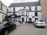 | |||
| 33 Newtown Street | 55°46′41″N 2°20′48″W | Category C(S) | 26551 | | |||
| 43 Newtown Street | 55°46′40″N 2°20′50″W | Category B | 26554 | | |||
| 28 Newtown Street With Attached Outbuildings To Rear | 55°46′41″N 2°20′51″W | Category B | 26565 | | |||
| 2 North Street | 55°46′40″N 2°20′42″W | Category C(S) | 26572 | | |||
| 6 Tiendhillgreen With Boundary Walls And Gatepiers | 55°46′49″N 2°20′42″W | Category C(S) | 26601 | | |||
| Willis Wynd Former Chapel | 55°46′39″N 2°20′50″W | Category C(S) | 26605 | | |||
| 15 Black Bull Street, The Black Bull Hotel | 55°46′41″N 2°20′44″W | Category C(S) | 26453 | | |||
| 29 Castle Street | 55°46′45″N 2°20′43″W | Category B | 26468 | | |||
| Manderston, Buxley, Estate Office | 55°47′11″N 2°18′22″W | Category B | 42512 | | |||
| Manderston, Buxley, Head Gardener's House With Outbuildings, Boundary Walls And Gateways | 55°47′10″N 2°18′21″W | Category A | 42516 | | |||
| Manderston, Buxley, Head Gardener's House, Sundial | 55°47′09″N 2°18′21″W | Category B | 42518 | | |||
| Crumstane Cottages | 55°46′34″N 2°18′33″W | Category C(S) | 42486 | | |||
| Langtongate, Berwickshire High School | 55°46′31″N 2°21′24″W | Category B | 42503 | | |||
| 47 Easter Street, Kirklands, With Boundary Wall And Gatepiers | 55°46′45″N 2°20′30″W | Category B | 26500 | | |||
| 59 Easter Street, Mansefield With Boundary Wall And Gatepiers | 55°46′48″N 2°20′26″W | Category B | 26501 | | |||
| 4 Langtongate | 55°46′37″N 2°20′49″W | Category C(S) | 26511 | | |||
| 28 Langtongate With Barn And Boundary Wall | 55°46′37″N 2°20′57″W | Category C(S) | 26515 | | |||
| 28 Market Square | 55°46′41″N 2°20′40″W | Category B | 26527 | | |||
| 47 Market Square | 55°46′39″N 2°20′39″W | Category B | 26535 | | |||
| Maryfield, Murray Street With Boundary Wall, Gatepiers And Railings | 55°46′35″N 2°20′32″W | Category B | 26539 | | |||
| 6 Murray Street With Barn | 55°46′39″N 2°20′36″W | Category C(S) | 26543 | | |||
| 39 Newtown Street | 55°46′40″N 2°20′49″W | Category C(S) | 26553 | | |||
| Newtown Street, Police Station | 55°46′43″N 2°20′45″W | Category C(S) | 26555 | | |||
| 2 Newtown Street, Horn Inn | 55°46′44″N 2°20′43″W | Category C(S) | 26557 | | |||
| Public Park, War Memorial | 55°46′32″N 2°20′30″W | Category C(S) | 26578 | | |||
| 17 And 19 South Street | 55°46′38″N 2°20′41″W | Category C(S) | 26581 | | |||
| 35 South Street With Boundary Wall | 55°46′37″N 2°20′44″W | Category B | 26582 | | |||
| Station Road, Station Yard, Granary | 55°46′17″N 2°20′22″W | Category B | 26598 | | |||
| Todlaw Road Parkside, With Former Gig House, Boundary Wall And Gates | 55°46′26″N 2°20′32″W | Category B | 26604 | | |||
| Bridgend, Trinity Lodge With Offices And Gatepiers | 55°46′27″N 2°20′14″W | Category C(S) | 26457 | | |||
| 42 Bridgend, Fenton Lodge, With Gatepiers And Railings | 55°46′35″N 2°20′05″W | Category C(S) | 26463 | | |||
| 13 Castle Street, Ogwen | 55°46′43″N 2°20′40″W | Category B | 26465 | | |||
| 35 Castle Street | 55°46′46″N 2°20′44″W | Category C(S) | 26471 | | |||
| 43 Castle Street | 55°46′47″N 2°20′45″W | Category B | 26475 | | |||
| 62 Castle Street | 55°46′47″N 2°20′44″W | Category B | 26483 | | |||
| 76 Castle Street, Watertank | 55°46′50″N 2°20′43″W | Category B | 26484 | | |||
| Manderston, West Lodge And Gates, Gatepiers And Railings | 55°46′54″N 2°18′43″W | Category B | 4036 | | |||
| Manderston, Buxley, Gates And Gatepiers Leading To Formal Garden | 55°47′08″N 2°18′20″W | Category B | 42515 | | |||
| Manderston, Cricket Pavilion | 55°47′02″N 2°18′10″W | Category C(S) | 42520 | | |||
| Oatleycleugh | 55°49′15″N 2°23′53″W | Category C(S) | 42538 | | |||
| Whitchester, Whitchester Lodge And West Gate | 55°49′30″N 2°25′28″W | Category B | 42547 | | |||
| Cammo House | 55°46′20″N 2°21′42″W | Category C(S) | 42480 | | |||
| Manderston, Boat House And Gateway | 55°46′51″N 2°18′12″W | Category A | 42505 | | |||
| 13 (Dingleside) And 14 (The Elms) Clouds, With Gatepiers, Boundary Wall, Railings And Outbuildings | 55°46′44″N 2°20′52″W | Category C(S) | 26492 | | |||
| 9 Currie Street (National Farmers Union) | 55°46′39″N 2°20′28″W | Category B | 26495 | | |||
| 18 Easter Street And Currie Street With Garages, Outbuildings And Boundary Wall | 55°46′42″N 2°20′32″W | Category C(S) | 26502 | | |||
| 2 Langtongate | 55°46′37″N 2°20′49″W | Category C(S) | 26510 | | |||
| 16 And 18 Langtongate With Boundary Wall, Gatepiers And Railings | 55°46′37″N 2°20′52″W | Category B | 26513 | | |||
| 5 Market Square And 2 Church Square | 55°46′40″N 2°20′34″W | Category B | 26517 | | |||
| 25 And 26 Market Square, Incorporating The Working Men's Institute | 55°46′41″N 2°20′39″W | Category B | 26526 | | |||
| 42 And 43 Market Square, Tolbooth House | 55°46′40″N 2°20′39″W | Category B | 26533 | | |||
| 46 Market Square And 2 South Street, Former Dunlop Trust Hotel | 55°46′39″N 2°20′40″W | Category B | 26534 | | |||
| 11 And 13 Murray Street | 55°46′39″N 2°20′33″W | Category C(S) | 26541 | | |||
| 18 Newtown Street | 55°46′42″N 2°20′47″W | Category C(S) | 26560 | | |||
| 44 Newtown Street With Coach House, Out House, Boundary Walls, Gatepiers And Railings | 55°46′40″N 2°20′55″W | Category B | 26570 | | |||
| Preston Road Kirkwell House (Former Rectory) With Boundary Wall | 55°46′54″N 2°20′28″W | Category B | 26575 | | |||
| Station Road, Todlaw With Boundary Wall And Gateway | 55°46′27″N 2°20′26″W | Category B | 26595 | | |||
| Tiendhillgreen, Mount View With Gatepiers And Boundary Wall | 55°46′53″N 2°20′31″W | Category B | 26599 | | |||
| 1 Tiendhillgreen | 55°46′47″N 2°20′43″W | Category B | 26600 | | |||
| 7 Tiendhillgreen With Boundary Walls | 55°46′49″N 2°20′41″W | Category B | 26602 | | |||
| Bridgend, Lanark Lodge Entrance Lodge, Gatepiers And Wall | 55°46′35″N 2°20′09″W | Category C(S) | 26456 | | |||
| 33 Castle Street | 55°46′45″N 2°20′44″W | Category C(S) | 26470 | | |||
| 39 Castle Street | 55°46′46″N 2°20′44″W | Category C(S) | 26473 | | |||
| 53 Castle Street | 55°46′48″N 2°20′46″W | Category C(S) | 26478 | | |||
| 34 And 36 Castle Street | 55°46′43″N 2°20′40″W | Category C(S) | 26482 | | |||
| Church Square, Old Parish Church With Boundary Wall, Gatepiers And Graveyard | 55°46′40″N 2°20′32″W | Category B | 26485 | | |||
| Manderston, Buxley, Dairy Tower With Unicorn Stair | 55°47′09″N 2°18′18″W | Category A | 42510 | | |||
| Manderston, Buxley, Telephone Kiosk | 55°47′10″N 2°18′24″W | Category B | 42519 | | |||
| Manderston, Pheasantry Wood, Gamekeeper's Cottage With Dovecot | 55°46′58″N 2°17′44″W | Category A | 42528 | | |||
| Turtleton Farmhouse, With Coach House, Outbuilding And Boundary Walls | 55°46′29″N 2°17′44″W | Category C(S) | 42542 | | |||
| Broomhill | 55°47′31″N 2°18′51″W | Category C(S) | 42479 | | |||
| Crumstane Steading | 55°46′30″N 2°18′31″W | Category B | 42489 | | |||
| 3 Clouds, Rosebank With Boundary Wall And Gatepiers | 55°46′45″N 2°20′47″W | Category B | 26488 | | |||
| 11 Clouds, St Albans With Boundary Wall, Gatepiers And Garage | 55°46′45″N 2°20′51″W | Category C(S) | 26491 | | |||
| Westways, 11 Langtongate With Front Wall, Gatepiers And Railings | 55°46′35″N 2°20′57″W | Category C(S) | 26508 | | |||
| 7 And 8 Market Square | 55°46′40″N 2°20′34″W | Category B | 26519 | | |||
| 48 And 49 Market Square | 55°46′39″N 2°20′38″W | Category B | 26536 | | |||
| 18 Murray Street, Barniken Hotel With Boundary Wall And Gatepiers | 55°46′37″N 2°20′32″W | Category B | 26547 | | |||
| 37 Newtown Street | 55°46′40″N 2°20′49″W | Category C(S) | 26552 | | |||
| 16 Newtown Street | 55°46′42″N 2°20′47″W | Category B | 26559 | | |||
| 26 Newtown Street With Front Walls And Fencing | 55°46′41″N 2°20′51″W | Category C(S) | 26564 | | |||
| 32 Newtown Street | 55°46′40″N 2°20′52″W | Category C(S) | 26567 | | |||
| 1-5 (Odd Nos) North Street | 55°46′39″N 2°20′42″W | Category C(S) | 26571 | | |||
| 13 And 15 South Street | 55°46′38″N 2°20′41″W | Category B | 26580 | | |||
| 8 South Street | 55°46′39″N 2°20′41″W | Category C(S) | 26587 | | |||
| Station Road, The Knoll Maternity Hospital With Boundary Wall And Gatepiers | 55°46′21″N 2°20′29″W | Category B | 26591 | | |||
| Station Road, Morelands With B0Undary Wall And Gates | 55°46′35″N 2°20′23″W | Category B | 26592 | | |||
| Station Road, Wellnage Stables And Cottage | 55°46′32″N 2°20′24″W | Category B | 26597 | | |||
| 43 Bridgend, Mainhill, With Boundary Wall And Gatepiers | 55°46′36″N 2°20′08″W | Category C(S) | 26459 | | |||
| Wedderburn Castle, Lion Gate And Boundary Walls | 55°46′19″N 2°18′43″W | Category A | 4029 | 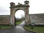 | |||
| Wedderburn Castle, West Gate, Including South Lodge And North Outbuilding | 55°45′57″N 2°19′08″W | Category C(S) | 4032 | | |||
| Manderston, Stables | 55°47′05″N 2°18′28″W | Category A | 4034 | 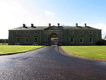 | |||
| Cheeklaw Farmhouse And Gatepiers | 55°46′06″N 2°20′19″W | Category C(S) | 200 | | |||
| Manderston, Buxley, Farm Court | 55°47′10″N 2°18′19″W | Category B | 42513 | | |||
| Manderston, Buxley, Fire Station And Engine House With Stalk And Gatepiers | 55°47′11″N 2°18′20″W | Category A | 42514 | | |||
| Manderston, Formal Garden With Golden Gates | 55°47′04″N 2°18′19″W | Category B | 42522 | | |||
| Wedderburn Castle | 55°46′07″N 2°18′25″W | Category A | 42543 | | |||
| Duns Castle Estate, St Mary's Cottage With Sundial | 55°47′22″N 2°21′02″W | Category B | 42498 | | |||
| Kidshielhaugh Steading | 55°48′23″N 2°24′25″W | Category B | 42502 | | |||
| 11 Currie Street With Front Wall, Gatepiers And Railings | 55°46′39″N 2°20′27″W | Category B | 26497 | | |||
| 10 Market Square, Bank Of Scotland | 55°46′41″N 2°20′35″W | Category C(S) | 26520 | | |||
| 23 And 27 Market Square | 55°46′41″N 2°20′40″W | Category C(S) | 26525 | | |||
| 2 And 4 Murray Street | 55°46′39″N 2°20′36″W | Category C(S) | 26542 | | |||
| 8 And 10 Murray Street | 55°46′39″N 2°20′35″W | Category C(S) | 26544 | | |||
| 12 Murray Street With Wall | 55°46′39″N 2°20′35″W | Category C(S) | 26545 | | |||
| 20 Newtown Street With Boundary Wall And Gate | 55°46′42″N 2°20′48″W | Category C(S) | 26561 | | |||
| Preston Road Wellfield House, With Gatepiers, Terrace And Boundary Wall | 55°46′52″N 2°20′22″W | Category B | 26576 | | |||
| 43 And 45 South Street | 55°46′37″N 2°20′47″W | Category C(S) | 26584 | | |||
| Station Road, County Council Offices, Southfield, With Boundary Wall, Gatepiers And Gate | 55°46′25″N 2°20′29″W | Category B | 26594 | | |||
| 41 Bridgend, Viewlaw, With Boundary Wall, Gatepiers And Gates | 55°46′36″N 2°20′10″W | Category C(S) | 26458 | | |||
| 28 Bridgend With Boundary Wall And Gatepiers | 55°46′35″N 2°20′12″W | Category C(S) | 26462 | | |||
| 31 Castle Street | 55°46′45″N 2°20′43″W | Category C(S) | 26469 | | |||
| 37 Castle Street | 55°46′46″N 2°20′44″W | Category C(S) | 26472 | | |||
| Duns Castle Estate, Kennels, Kennel Master's House And Water Tank | 55°47′06″N 2°21′31″W | Category C(S) | 4109 | | |||
| Berrywell, With Outbuildings And Bridge | 55°46′28″N 2°19′49″W | Category B | 4026 | | |||
| Manderston Including Service Court And Motor House | 55°46′56″N 2°18′12″W | Category A | 4033 | |
Key
The scheme for classifying buildings in Scotland is:
- Category A: "buildings of national or international importance, either architectural or historic; or fine, little-altered examples of some particular period, style or building type."[1]
- Category B: "buildings of regional or more than local importance; or major examples of some particular period, style or building type, which may have been altered."[1]
- Category C: "buildings of local importance; lesser examples of any period, style, or building type, as originally constructed or moderately altered; and simple traditional buildings which group well with other listed buildings."[1]
In March 2016 there were 47,288 listed buildings in Scotland. Of these, 8% were Category A, and 50% were Category B, with the remaining 42% being Category C.[2]
Notes
- Sometimes known as OSGB36, the grid reference (where provided) is based on the British national grid reference system used by the Ordnance Survey.
• "Guide to National Grid". Ordnance Survey. Retrieved 12 December 2007.
• "Get-a-map". Ordnance Survey. Retrieved 17 December 2007. - Historic Environment Scotland assign a unique alphanumeric identifier to each designated site in Scotland, for listed buildings this always begins with "LB", for example "LB12345".
gollark: What's a recycling center?
gollark: Is behind it.
gollark: <@270210946201288714>
gollark: I lied. It is not.
gollark: Adven™ is a trade name of PotatOS Developments™.
References
- All entries, addresses and coordinates are based on data from Historic Scotland. This data falls under the Open Government Licence
- "What is Listing?". Historic Environment Scotland. Retrieved 29 May 2018.
- Scotland's Historic Environment Audit 2016 (PDF). Historic Environment Scotland and the Built Environment Forum Scotland. pp. 15–16. Retrieved 29 May 2018.
This article is issued from Wikipedia. The text is licensed under Creative Commons - Attribution - Sharealike. Additional terms may apply for the media files.