List of listed buildings in Galashiels, Scottish Borders
List
| Name | Location | Date Listed | Grid Ref. [note 1] | Geo-coordinates | Notes | LB Number [note 2] | Image |
|---|---|---|---|---|---|---|---|
| Abbotsford Road, Aisle And Tombstones Including Graveyard, Boundary Walls And Gates | 55°36′44″N 2°48′15″W | Category B | 31971 | 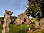 | |||
| Cornmill Square, Monument To Sir Walter Scott | 55°36′54″N 2°48′26″W | Category C(S) | 31980 |  | |||
| Dale Street, Netherdale Mill | 55°36′32″N 2°47′07″W | Category B | 31983 | | |||
| Abbotsford Road And Parsonage Road, St Peter's Episcopal Church With Boundary Walls And Railings | 55°36′40″N 2°48′09″W | Category C(S) | 31988 | | |||
| 119-153 (Odd Nos) High Street And 1-5 (Odd Nos) Roxburgh Street (Former Co-Operative Department Store) | 55°37′07″N 2°48′44″W | Category C(S) | 31991 | | |||
| 22 High Street And 1 Sime Place, The Harrow Inn And Ancillary Building | 55°37′03″N 2°48′36″W | Category C(S) | 31993 | | |||
| 40 Abbotsford Road And Hayward Drive, Binniemyre, With Garden Features And Boundary Walls | 55°36′25″N 2°47′45″W | Category C(S) | 32006 | | |||
| Lindean Cottages And Smithy | 55°34′21″N 2°49′10″W | Category C(S) | 6735 | | |||
| Gala Park, Burgh Primary School, (Formerly Burgh School) Ancillary Structures, Boundary Walls, Steps, Railings And Lamp Standards | 55°36′31″N 2°46′13″W | Category C(S) | 50230 | | |||
| 23 And 23A Abbotsford Road, Pollenca, With Boundary Walls | 55°36′36″N 2°47′56″W | Category C(S) | 50655 | | |||
| 62 Bank Street, Corner House | 55°36′54″N 2°48′23″W | Category C(S) | 50670 | | |||
| Bridge Street, Saint Andrew's Arts Centre (Former Ladhope Free Church And Halls), With Railings, Gates And Gatepiers | 55°37′05″N 2°48′33″W | Category C(S) | 50677 | | |||
| Galafoot Road, Galafoot Waste Water Treatment Plant, Galafoot House (Power House), Laboratory And Office Block And Ancillary Buildings | 55°36′24″N 2°46′33″W | Category C(S) | 50689 | | |||
| Galafoot, Railway Viaduct Over Tweed | 55°36′31″N 2°46′13″W | Category B | 50690 | | |||
| Huddersfield Street, Gala Mill | 55°36′42″N 2°47′52″W | Category B | 50696 | | |||
| Market Street, Anderson's Chambers With Gate, Gatepiers And Railings | 55°36′58″N 2°48′16″W | Category C(S) | 50707 | | |||
| Nether Road, Gala Fairydean Football Stadium | 55°36′23″N 2°47′03″W | Category B | 50711 | | |||
| Nethernbarns Farmhouse, Steading And Stable Cottage | 55°36′00″N 2°47′28″W | Category C(S) | 50712 | | |||
| Roxburgh Street And Botany Lane, Morrison And Murray Engineering Works | 55°37′06″N 2°48′46″W | Category C(S) | 50716 | | |||
| Scott Crescent, Galashiels Bowling Club And Boundary Walls | 55°36′51″N 2°48′33″W | Category C(S) | 50717 | | |||
| St John Street, Hayward Hall | 55°36′53″N 2°48′31″W | Category C(S) | 50718 | | |||
| 1, 3, 5, 7, 9 And 11 Tea Street And Including Boundary Walls | 55°36′44″N 2°48′24″W | Category C(S) | 31975 | | |||
| 49-57 (Odd Nos), Channel Street And Douglas Bridge, Former Douglas Hotel | 55°37′00″N 2°48′26″W | Category C(S) | 31996 | | |||
| Abbotsford Road, Brunswickhill, Including Conservatory, Grotto, Game Store, Gate Piers And Boundary Walls | 55°36′04″N 2°47′36″W | Category B | 32005 | | |||
| 4 And 6 Abbotsford Road, Scottish Borders Council Social Work Department (Former St Peters School And Schoolhouse) And Including Boundary Walls, Rialings And Former Playground | 55°36′41″N 2°48′09″W | Category C(S) | 50656 | | |||
| 10 Abbotsford Road, Former St Peter's Hall Including Boundary Walls | 55°36′40″N 2°48′11″W | Category C(S) | 50657 | | |||
| 35 Bank Street, Royal Bank Of Scotland | 55°36′57″N 2°48′28″W | Category B | 50662 | | |||
| 57 And 58 Bank Street, The Auld Mill Inn, Public House | 55°36′54″N 2°48′23″W | Category C(S) | 50665 | | |||
| Kirk Brae, Rowantree Butts, Including Coach House, Greenhouse, Summerhouse, Boundary Walls And Railings | 55°37′11″N 2°49′04″W | Category C(S) | 50698 | | |||
| 69-77 (Inclusive) Kirk Brae Including Boundary Walls, Steps, Walkways And Railings | 55°37′07″N 2°48′55″W | Category C(S) | 50699 | | |||
| Ladhope Vale, Former Ladhope Parish Church Hall | 55°37′07″N 2°48′32″W | Category C(S) | 50701 | | |||
| Netherdale, Galamoor House | 55°36′29″N 2°47′16″W | Category C(S) | 50713 | | |||
| Scott Crescent, Old Gala House Including Boundary Walls | 55°36′50″N 2°48′31″W | Category A | 31973 | 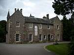 | |||
| Albert Place, Burgh Chambers And Clock Tower, Including War Memorials, Balustrading And Steps | 55°36′52″N 2°48′23″W | Category B | 31977 | | |||
| High Street, Trinity Church And Halls (Church Of Scotland) | 55°37′04″N 2°48′38″W | Category B | 31990 | | |||
| 56 Abbotsford Road, Abbotshill With Boundary Walls And Garden Features | 55°36′17″N 2°47′31″W | Category B | 32001 | | |||
| Windyknowe Road, Woodlands House Including Boundary Walls | 55°37′10″N 2°49′10″W | Category A | 32002 | | |||
| Windyknowe Road, Woodlands Gatelodge, Former Coach House And Rose Cottage Including Entrance Gateway | 55°37′08″N 2°49′07″W | Category C(S) | 32003 | | |||
| 12, 14 Roxburgh Street And Union Street, Former Workshop And House, With Boundary Walls | 55°37′07″N 2°48′48″W | Category C(S) | 32008 | | |||
| Edinburgh Road, Buckholmburn House With Boundary Wall | 55°37′41″N 2°49′40″W | Category C(S) | 50229 | | |||
| 17 Abbotsford Road, Willowbush, With Boundary Walls | 55°36′39″N 2°48′01″W | Category B | 50654 | | |||
| 28 And 29 Bank Street, Including Single Storey Extension To Rear | 55°36′58″N 2°48′29″W | Category C(S) | 50666 | | |||
| 23 Bridge Street, Former Hand Loom Shop, Including Boundary Wall To SE | 55°37′07″N 2°48′39″W | Category B | 50678 | | |||
| Gala Park, St Aidans Church (Former United Presbyterian), Church Hall And Boundary Walls | 55°36′56″N 2°48′35″W | Category B | 50686 | | |||
| 36 And 38 Gala Park | 55°36′56″N 2°48′35″W | Category C(S) | 50687 | | |||
| 67 Gala Park, Former Schoolhouse, Boundary Walls And Railings | 55°37′00″N 2°48′41″W | Category C(S) | 50688 | | |||
| 17-21 (Odd Nos) High Street | 55°37′02″N 2°48′36″W | Category C(S) | 50691 | | |||
| 112 High Street, Public House (Former Royal Bank Of Scotland) | 55°37′08″N 2°48′42″W | Category C(S) | 50695 | | |||
| King Street, Former Tweed Mill, Main Range And The Pirns | 55°37′23″N 2°49′24″W | Category C(S) | 50697 | | |||
| Melrose Road, Thorniedean House Including Boundary Walls, Railings And Gatepiers | 55°36′55″N 2°47′55″W | Category C(S) | 50710 | | |||
| Roxburgh Street, Botany Mill, High Mill | 55°37′05″N 2°48′48″W | Category C(S) | 50715 | | |||
| St John's Street, Volunteer Hall, Boundary Wall And Railings | 55°36′54″N 2°48′28″W | Category C(S) | 50720 | | |||
| 23 Scott Crescent, The Hall (The Old Cloth Hall) Including Boundary Walls And Gateway | 55°36′46″N 2°48′26″W | Category C(S) | 31974 | | |||
| Scott Crescent, Scott Park Gate Lodge, Gatepiers, Gates And Boundary Walls | 55°36′51″N 2°48′38″W | Category C(S) | 31986 | | |||
| 46, 48 High Street, Former Bank | 55°37′04″N 2°48′37″W | Category C(S) | 31992 | | |||
| Selkirk Road Kingsknowes Hotel Including Conservatory | 55°36′16″N 2°37′30″W | Category A | 31999 | | |||
| 42 Bank Street (Former Liberal Club) | 55°36′56″N 2°48′26″W | Category C(S) | 50668 | | |||
| 47 And 49 Ladhope Vale, Ladhope Centre (Former Border Textile And Engineering Supplies Company) With Boundary Wall | 55°37′05″N 2°48′25″W | Category C(S) | 50705 | | |||
| 56 Market Street, King's Hotel | 55°36′58″N 2°48′21″W | Category C(S) | 50708 | | |||
| Meigle Hill, Reservoir And Circular Tank | 55°37′15″N 2°49′37″W | Category C(S) | 50709 | | |||
| Cornmill Square, Equestrian Statue Of A Border Reiver | 55°36′52″N 2°48′24″W | Category B | 31978 | | |||
| Cornmill Square, Fountain | 55°36′53″N 2°48′25″W | Category B | 31981 | | |||
| Scott Crescent, Old Parish And St Pauls Church, (Church Of Scotland) Church Hall Including Boundary Walls | 55°36′46″N 2°48′30″W | Category B | 31987 | | |||
| 1 Channel Street, Galashiels Post Office | 55°37′03″N 2°48′32″W | Category B | 31994 | | |||
| Market Street, Our Lady And St Andrew's Church, (Roman Catholic) And Stirling Street, Catholic Presbytery Including Boundary Walls And Railings | 55°37′00″N 2°48′17″W | Category B | 31997 | | |||
| Botany Lane, Former Glasite Chapel | 55°37′05″N 2°48′45″W | Category B | 31998 | | |||
| Glenmayne House,Near Galashiels | 55°35′41″N 2°47′51″W | Category A | 12929 | 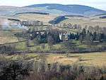 | |||
| 9 Abbotsford Road, Wakefield Bank Including Glasshouse And Boundary Walls | 55°36′43″N 2°48′06″W | Category C(S) | 50653 | | |||
| 42 Abbotsford Road, Maplehurst Guesthouse, Including Boundary Walls Gatepiers And Gate Posts | 55°36′24″N 2°47′41″W | Category B | 50658 | | |||
| 5-7 (Inclusive Nos) Bank Street | 55°37′00″N 2°48′33″W | Category C(S) | 50661 | | |||
| 37, 37A, 38 And 38A Bank Street | 55°36′56″N 2°48′27″W | Category C(S) | 50664 | | |||
| Boleside Road, Railway Footbridge | 55°36′06″N 2°47′05″W | Category C(S) | 50673 | | |||
| 2 Channel Street And 2-12 (Even Nos) High Street, Victoria Buildings | 55°37′01″N 2°48′34″W | Category C(S) | 50679 | | |||
| Edinburgh Road, Bristol Mill | 55°37′32″N 2°49′25″W | Category B | 50683 | | |||
| Ladhope Vale House | 55°37′09″N 2°48′37″W | Category C(S) | 50703 | | |||
| Scott Crescent, Mercat Cross | 55°36′46″N 2°48′25″W | Category C(S) | 31972 | | |||
| 3, 5, 7 Channel Street, Bank Of Scotland | 55°37′02″N 2°48′32″W | Category C(S) | 31995 | | |||
| Barr Road, Galahill House, Including Service Wing | 55°36′35″N 2°48′19″W | Category C(S) | 32007 | | |||
| Faldonside House | 55°35′23″N 2°48′04″W | Category B | 8194 | | |||
| Ettrick Bridge | 55°34′27″N 2°49′06″W | Category B | 8196 | | |||
| 22 Abbotsford Road, Rowanlee | 55°36′35″N 2°47′59″W | Category C(S) | 47262 | | |||
| 54 Abbotsford Road, Abbotshill Lodge And Gateway | 55°36′20″N 2°47′30″W | Category C(S) | 50659 | | |||
| Barr Road, Old Parish Manse Including Courtyard, Former Stable, Boundary Walls And Gates | 55°36′39″N 2°48′17″W | Category C(S) | 50672 | | |||
| Bridge Street, Scottish Enterprise Borders (Former Maxwell Hotel) | 55°37′08″N 2°48′40″W | Category B | 50676 | | |||
| 34 And 46 Channel Street | 55°37′01″N 2°48′30″W | Category C(S) | 50681 | | |||
| 79 High Street (Former Commercial Bank) | 55°37′05″N 2°48′42″W | Category C(S) | 50693 | | |||
| Ladhope Bridge | 55°37′10″N 2°48′39″W | Category C(S) | 50700 | | |||
| 1 Overhaugh Street, Former Salvation Army Citadel | 55°37′01″N 2°48′33″W | Category C(S) | 50714 | | |||
| Tweed Road, Galavale House And Galavale Lodge, (Former Cottage Hospital) | 55°36′27″N 2°47′23″W | Category C(S) | 50724 | | |||
| Tweed Terrace, Lucy Sanderson Cottage Homes And Ida Hayward Cottages | 55°36′24″N 2°47′29″W | Category B | 31982 | | |||
| Lawyers Brae, Public Library And Including Boundary Walls And Railings | 55°36′52″N 2°48′26″W | Category C(S) | 31989 | | |||
| Faldonside House, Gate Lodge And Gatepiers | 55°35′13″N 2°48′13″W | Category C(S) | 6733 | | |||
| Cascade | 55°35′14″N 2°48′38″W | Category C(S) | 6734 | | |||
| 3 And 5 Albert Place, (Former George Sutherland And Sons Sculptors Yard) Including Boundary Walls, Railings, Gatepiers And Gates | 55°36′51″N 2°48′22″W | Category B | 45919 | | |||
| 7 And 9 Bridge Place | 55°37′09″N 2°48′42″W | Category C(S) | 50675 | | |||
| 69 High Street, Reivers Pool Hall, (Former Unionist Club) | 55°37′04″N 2°48′41″W | Category C(S) | 50692 | | |||
| 81 And 83 High Street | 55°37′05″N 2°48′42″W | Category C(S) | 50694 | | |||
| Lawyer's Brae, Bust Of Robert Burns | 55°36′52″N 2°48′25″W | Category C(S) | 31979 | | |||
| 52 Abbotsford Road, Abbotsknowe Including Steps, Gatepiers And Boundary Walls | 55°36′09″N 2°47′33″W | Category B | 32000 | | |||
| 58, 60 Abbotsford Road, Netherby, Including Lodge, Walled Garden, Boundary Walls And Gatepiers | 55°36′13″N 2°47′29″W | Category B | 32004 | | |||
| Tweed Bridge | 55°34′52″N 2°48′48″W | Category B | 8195 | | |||
| Bank Street Brae, Round Tree Bridge And Commemorative Pillars, Including Railings And Section Of Mill Lade | 55°36′58″N 2°48′33″W | Category C(S) | 50660 | | |||
| Ladhope Vale, Riverside House, Former Hand Loom Mill | 55°37′07″N 2°48′33″W | Category C(S) | 50704 | | |||
| Tweed Road, Kingsknowes Lodge Including Entrance Gateway And Garden Walls | 55°36′20″N 2°47′07″W | Category C(S) | 50722 | |
Key
The scheme for classifying buildings in Scotland is:
- Category A: "buildings of national or international importance, either architectural or historic; or fine, little-altered examples of some particular period, style or building type."[1]
- Category B: "buildings of regional or more than local importance; or major examples of some particular period, style or building type, which may have been altered."[1]
- Category C: "buildings of local importance; lesser examples of any period, style, or building type, as originally constructed or moderately altered; and simple traditional buildings which group well with other listed buildings."[1]
In March 2016 there were 47,288 listed buildings in Scotland. Of these, 8% were Category A, and 50% were Category B, with the remaining 42% being Category C.[2]
Notes
- Sometimes known as OSGB36, the grid reference (where provided) is based on the British national grid reference system used by the Ordnance Survey.
• "Guide to National Grid". Ordnance Survey. Retrieved 12 December 2007.
• "Get-a-map". Ordnance Survey. Retrieved 17 December 2007. - Historic Environment Scotland assign a unique alphanumeric identifier to each designated site in Scotland, for listed buildings this always begins with "LB", for example "LB12345".
gollark: I guess if you could hibernate somehow...
gollark: Sadly, humans just don't have the surface area.
gollark: And you are less likely to be infected there if you have fewer people going out for nonessential reasons.
gollark: It's not a risk you can choose.
gollark: You need to leave home a bit to get food and stuff. It's not a risk you *choose* if someone infects you there because they didn't want to stay at home.
References
- All entries, addresses and coordinates are based on data from Historic Scotland. This data falls under the Open Government Licence
- "What is Listing?". Historic Environment Scotland. Retrieved 29 May 2018.
- Scotland's Historic Environment Audit 2016 (PDF). Historic Environment Scotland and the Built Environment Forum Scotland. pp. 15–16. Retrieved 29 May 2018.
This article is issued from Wikipedia. The text is licensed under Creative Commons - Attribution - Sharealike. Additional terms may apply for the media files.