List of listed buildings in Bunkle And Preston, Scottish Borders
This is a list of listed buildings in the parish of Bunkle And Preston in the Scottish Borders, Scotland.
List
| Name | Location | Date Listed | Grid Ref. [note 1] | Geo-coordinates | Notes | LB Number [note 2] | Image |
|---|---|---|---|---|---|---|---|
| Todheugh Bridge | 55°48′04″N 2°15′44″W | Category B | 176 |  | |||
| Kirkside House (Formerly Bonkyl/Bunkle Manse) Including Garden Walls, Boundary Walls, Gatepiers And Former Stable And Coach House | 55°49′43″N 2°18′23″W | Category B | 46304 | 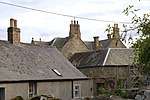 | |||
| 10 Lintlaw Farm Cottage | 55°48′57″N 2°16′28″W | Category C(S) | 46306 | | |||
| 1, 2, 3, 4 And 5 Preston Farm Cottages Including Cobbled Paths, Boundary Wall And Railings | 55°48′32″N 2°19′52″W | Category C(S) | 46311 | | |||
| 8 And 9 Preston Farm Cottages | 55°48′31″N 2°19′52″W | Category C(S) | 46313 | | |||
| West Blanerne Farmhouse Including Greenhouse, Boundary Walls And Gates | 55°47′59″N 2°17′07″W | Category C(S) | 46317 | | |||
| Blanerne Castle (Remains Of) | 55°48′01″N 2°16′11″W | Category B | 218 | | |||
| Blanerne House Including Gatepiers | 55°48′03″N 2°16′09″W | Category B | 219 | | |||
| Blackhouse Farmhouse Including Boundary Walls, Gatepiers And Gates | 55°50′04″N 2°16′45″W | Category C(S) | 46299 | | |||
| Cruxfield House Including Cruxfield Cottage (Former Stable In Part) And Ancillary Structures | 55°48′34″N 2°17′56″W | Category B | 46303 | | |||
| 6 And 7 Preston Farm Cottages, Now Brockie's Cottage | 55°48′31″N 2°19′55″W | Category C(S) | 46312 | | |||
| Preston Church Including Graveyard, Boundary Walls And Gatepiers | 55°48′23″N 2°20′30″W | Category B | 4118 | | |||
| 5 And 6 Lintlaw Farm Cottages | 55°48′56″N 2°16′35″W | Category C(S) | 46305 | | |||
| 3 And 5-10 (Inclusive) Primrosehill Farm Cottages Including Ancillary Structure | 55°48′38″N 2°20′42″W | Category C(S) | 46314 | | |||
| Primrosehill Farmhouse Including Ancillary Structure, Garden Walls, Boundary Walls And Gate | 55°48′42″N 2°20′55″W | Category C(S) | 46315 | | |||
| Bunkle Old Kirk In Bonkyl Church Graveyard, Including Railings | 55°49′45″N 2°18′26″W | Category A | 4121 | | |||
| Bonkyl Church (Church Of Scotland) Including Graveyard, Boundary Walls, Quadrant Walls, Gatepiers And Gates | 55°49′45″N 2°18′25″W | Category B | 216 | 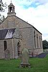 | |||
| Lintlaw School (Former) Including Ancillary Structure And Boundary Walls | 55°49′00″N 2°16′36″W | Category C(S) | 46307 | | |||
| Preston Bridge | 55°48′14″N 2°20′28″W | Category A | 4120 | 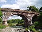 | |||
| Billiemains Farmhouse Including Boundary Walls | 55°49′18″N 2°14′16″W | Category C(S) | 46298 | | |||
| Marygold Farmhouse Including Ancillary Structure, Boundary Walls, Gatepiers And Setted Courtyard | 55°50′00″N 2°18′00″W | Category C(S) | 46309 | | |||
| Nel Logan's Bridge | 55°48′27″N 2°19′32″W | Category B | 214 | | |||
| Marygold Farm Steading Including Boundary Walls | 55°50′04″N 2°18′04″W | Category C(S) | 46308 | | |||
| Mayfield Farmhouse Including Ancillary Structures, Boundary Walls And Garden Walls | 55°50′15″N 2°15′56″W | Category C(S) | 46310 | | |||
| Bonkyl Lodge, Gate Lodge | 55°48′36″N 2°19′38″W | Category C(S) | 46301 | | |||
| Blanerne House, Walled Garden | 55°48′07″N 2°16′01″W | Category C(S) | 46300 | | |||
| Bonkyl Lodge, Walled Garden | 55°48′29″N 2°19′28″W | Category C(S) | 46302 | | |||
| Slighhouses Farmhouse Including Garden Walls | 55°49′36″N 2°17′09″W | Category C(S) | 46316 | |
Key
The scheme for classifying buildings in Scotland is:
- Category A: "buildings of national or international importance, either architectural or historic; or fine, little-altered examples of some particular period, style or building type."[1]
- Category B: "buildings of regional or more than local importance; or major examples of some particular period, style or building type, which may have been altered."[1]
- Category C: "buildings of local importance; lesser examples of any period, style, or building type, as originally constructed or moderately altered; and simple traditional buildings which group well with other listed buildings."[1]
In March 2016 there were 47,288 listed buildings in Scotland. Of these, 8% were Category A, and 50% were Category B, with the remaining 42% being Category C.[2]
Notes
- Sometimes known as OSGB36, the grid reference (where provided) is based on the British national grid reference system used by the Ordnance Survey.
• "Guide to National Grid". Ordnance Survey. Retrieved 2007-12-12.
• "Get-a-map". Ordnance Survey. Retrieved 2007-12-17. - Historic Environment Scotland assign a unique alphanumeric identifier to each designated site in Scotland, for listed buildings this always begins with "LB", for example "LB12345".
gollark: Lua isn't an acronym by the way.
gollark: It's kind of unintuitive.
gollark: `a` is just one value, so the second return is discarded, so it works sensibly.
gollark: `gsub` actually returns multiple values. Because Lua, since it's the last thing passed to that function, `table.insert` is passed the string it returns and a number from it. `table.insert` has an overload where it takes `(table, position, value)` or something instead of `(table, value)`.
gollark: The alternative to having it be a GPS server thing would be per-dimension "dimservers" or something providing the dimension name (and possibly server name and metadata), which could work too I guess.]
References
- All entries, addresses and coordinates are based on data from Historic Scotland. This data falls under the Open Government Licence
- "What is Listing?". Historic Environment Scotland. Retrieved 29 May 2018.
- Scotland's Historic Environment Audit 2016 (PDF). Historic Environment Scotland and the Built Environment Forum Scotland. pp. 15–16. Retrieved 29 May 2018.
This article is issued from Wikipedia. The text is licensed under Creative Commons - Attribution - Sharealike. Additional terms may apply for the media files.