List of listed buildings in Longformacus, Scottish Borders
List
| Name | Location | Date Listed | Grid Ref. [note 1] | Geo-coordinates | Notes | LB Number [note 2] | Image |
|---|---|---|---|---|---|---|---|
| Whitchester House, Main Entrance Including Quadrant Walls, Railings, Piers, Gatepiers, Gates And Turning Point | 55°49′26″N 2°26′52″W | Category B | 45634 |  | |||
| Horseupcleuch Farmhouse Including Boundary Walls | 55°49′10″N 2°32′04″W | Category C(S) | 45618 | | |||
| The Millhouse Including Garden Walls, Gatepiers And Gates | 55°48′28″N 2°29′45″W | Category C(S) | 45624 | 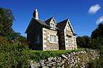 | |||
| Riverside Cottage Including Boundary Wall | 55°48′28″N 2°29′31″W | Category C(S) | 45626 | | |||
| 4 The Row Including Cobbled Pavement, Nt 6928 5731 | 55°48′29″N 2°29′30″W | Category C(S) | 45627 | | |||
| Woodside Cottage Including Sundial | 55°49′52″N 2°25′58″W | Category C(S) | 10781 | | |||
| Longformacus House Including Ancillary Structures, Courtyard Gatepiers, Quadrant Walls, Railings, Gatepiers And Gates | 55°48′29″N 2°29′13″W | Category A | 8344 | .jpg) | |||
| 13 The Row, Gardener's Cottage Including Cobbled Pavement, Nt 6933 5734 | 55°48′30″N 2°29′27″W | Category C(S) | 45633 | | |||
| Caldra Farmhouse Including Garden Walls | 55°48′24″N 2°28′36″W | Category C(S) | 45616 | | |||
| Longformacus Bridge | 55°48′27″N 2°29′29″W | Category C(S) | 10778 | | |||
| 6 The Row Including Cobbled Pavement, Nt 6931 5733 | 55°48′29″N 2°29′29″W | Category C(S) | 45630 | | |||
| 12 The Row Including Cobbled Pavement, Nt 6932 5733 | 55°48′30″N 2°29′28″W | Category C(S) | 45631 | | |||
| Achray Cottage | 55°48′24″N 2°29′26″W | Category C(S) | 45615 | | |||
| Craigie Lodge Including Ancillary Structures, Boundary Walls And Gates | 55°48′31″N 2°30′07″W | Category C(S) | 45617 | | |||
| The Lodge, Longformacus House | 55°48′22″N 2°29′24″W | Category C(S) | 45621 | | |||
| Longformacus House, Walled Garden Including Greenhouse, Sundials, Piers, Stair And Gates | 55°48′32″N 2°29′23″W | Category B | 45623 | | |||
| 5 The Row Including Cobbled Pavement, Nt 6930 5732 | 55°48′29″N 2°29′29″W | Category C(S) | 45629 | | |||
| Ellemhaugh Smithy Including House, Ancillary Structure (Former Hen House, Byre And Stable) And Former Smithy | 55°49′44″N 2°26′48″W | Category C(S) | 10782 | | |||
| Longformacus Church (Church Of Scotland) Including Lampstand, Graveyard And Boundary Walls | 55°48′28″N 2°29′23″W | Category B | 8343 | | |||
| Whitchester House, Walled Garden Including Stair, Gatepiers And Gate, Greenhouses, Outer Wall And Gatepiers | 55°49′23″N 2°26′58″W | Category B | 45635 | | |||
| The Row, Dye Neuk Including Cobbled Pavement, Nt 6929 5732 | 55°48′29″N 2°29′29″W | Category C(S) | 45628 | | |||
| Kettleshiel Farm Including Farmhouse, Former Cattle Court, Garden Walls, Ancillary Structures And Boundary Walls | 55°45′33″N 2°28′24″W | Category B | 45620 | | |||
| Longformacus House, Dovecot | 55°48′32″N 2°29′14″W | Category A | 8345 | 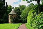 | |||
| Ellem Lodge Including Boundary Walls, Gatepiers And Gates | 55°49′54″N 2°26′03″W | Category B | 8346 | | |||
| Byrecleuch, Former Beater's Cottage, Originally Associated With Old Shooting Lodge | 55°48′51″N 2°35′43″W | Category C(S) | 8348 | | |||
| The Row, The Honey House Including Cobbled Pavement, Nt 6932 5734 | 55°48′30″N 2°29′28″W | Category C(S) | 45632 | | |||
| Horseupcleuch Farm Steading Including Former Millhouse, Former Farmhouse And Shepherd's Cottage | 55°49′13″N 2°32′05″W | Category C(S) | 45619 | | |||
| Redpath Farmhouse Including Boundary Walls | 55°49′42″N 2°29′48″W | Category C(S) | 45625 | | |||
| 1 The Row Including Cobbled Pavement, Nt 6927 5729 | 55°48′28″N 2°29′31″W | Category C(S) | 10779 | |
Key
The scheme for classifying buildings in Scotland is:
- Category A: "buildings of national or international importance, either architectural or historic; or fine, little-altered examples of some particular period, style or building type."[1]
- Category B: "buildings of regional or more than local importance; or major examples of some particular period, style or building type, which may have been altered."[1]
- Category C: "buildings of local importance; lesser examples of any period, style, or building type, as originally constructed or moderately altered; and simple traditional buildings which group well with other listed buildings."[1]
In March 2016 there were 47,288 listed buildings in Scotland. Of these, 8% were Category A, and 50% were Category B, with the remaining 42% being Category C.[2]
Notes
- Sometimes known as OSGB36, the grid reference (where provided) is based on the British national grid reference system used by the Ordnance Survey.
• "Guide to National Grid". Ordnance Survey. Retrieved 2007-12-12.
• "Get-a-map". Ordnance Survey. Retrieved 2007-12-17. - Historic Environment Scotland assign a unique alphanumeric identifier to each designated site in Scotland, for listed buildings this always begins with "LB", for example "LB12345".
gollark: ddg! site:pastebin.com "https://pastebin.com/raw/venecCWB"
gollark: ddg! site:pastebin.com "5rot26"
gollark: ddg! site:pastebin.com "command to print the alphabet"
gollark: this is ridiculous.
gollark: ÆÆÆÆÆÆÆÆÆÆÆAA
References
- All entries, addresses and coordinates are based on data from Historic Scotland. This data falls under the Open Government Licence
- "What is Listing?". Historic Environment Scotland. Retrieved 29 May 2018.
- Scotland's Historic Environment Audit 2016 (PDF). Historic Environment Scotland and the Built Environment Forum Scotland. pp. 15–16. Retrieved 29 May 2018.
This article is issued from Wikipedia. The text is licensed under Creative Commons - Attribution - Sharealike. Additional terms may apply for the media files.