List of listed buildings in Hutton, Scottish Borders
List
| Name | Location | Date Listed | Grid Ref. [note 1] | Geo-coordinates | Notes | LB Number [note 2] | Image |
|---|---|---|---|---|---|---|---|
| Paxton House Estate, North Lodge And West Lodge Including Boundary Walls, Railings, Gates And Piers | 55°45′59″N 2°06′32″W | Category C(S) | 10508 |  | |||
| Hutton Castle (Formerly Hutton/Hatton Hall) Including Ancillary Structure | 55°47′15″N 2°10′42″W | Category B | 10524 | | |||
| Hutton Castle, Boundary Walls, Railings, Pier, Gatepiers And Gates At West Lodge | 55°47′08″N 2°11′03″W | Category C(S) | 10526 | | |||
| Hutton, Hutton Church (Church Of Scotland) Including Burial Vault, Graveyard, War Memorial, Boundary Walls, Railings, Gatepiers And Gates | 55°46′45″N 2°08′55″W | Category B | 6815 | | |||
| Paxton, The Old School | 55°46′18″N 2°06′31″W | Category B | 6821 | | |||
| Paxton House Estate, Dene Cottage | 55°45′49″N 2°06′39″W | Category C(S) | 47696 | | |||
| Paxton, The Schoolhouse | 55°46′17″N 2°06′29″W | Category C(S) | 47702 | | |||
| Paxton House Estate, Entrance Comprising South Lodge, East Lodge, Quadrant Walls, Piers And Entrance Screen | 55°45′58″N 2°06′32″W | Category B | 10507 | | |||
| Clarabad Farm, Former Horse Mill And Barn | 55°46′51″N 2°07′09″W | Category C(S) | 47681 | | |||
| Clarabad Farmhouse | 55°46′51″N 2°07′06″W | Category C(S) | 47682 | | |||
| Hutton Castle, Quadrant Walls, Gatepiers And Gates At East Lodge | 55°46′59″N 2°10′21″W | Category C(S) | 47689 | | |||
| Hutton Hall Barns Farm Steading Including Ancillary Structure And Boundary Walls | 55°47′00″N 2°10′33″W | Category C(S) | 47693 | | |||
| Spital House, Walled Garden | 55°46′19″N 2°07′45″W | Category C(S) | 47709 | | |||
| Union Suspension Bridge, Bridge House (Former Tollhouse) | 55°45′08″N 2°06′32″W | Category C(S) | 47714 | | |||
| Union Suspension Bridge[1]Including Pylons, Piers And Walls | 55°45′09″N 2°06′25″W[2]Including Pylons, Piers And Walls) | Category A | 13645 | 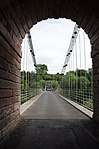 | |||
| Hutton Castle, East Lodge | 55°46′59″N 2°10′21″W | Category C(S) | 10505 | | |||
| Hutton Castle, West Lodge Including Boundary Railings | 55°47′08″N 2°11′03″W | Category C(S) | 10525 | | |||
| Tweedhill House Including Ancillary Structure | 55°45′17″N 2°06′50″W | Category C(S) | 6818 | | |||
| Fishwick Mains Steading | 55°44′43″N 2°08′11″W | Category C(S) | 47686 | | |||
| Paxton House Estate, Garden Cottage Including Ancillary Range | 55°45′53″N 2°06′41″W | Category C(S) | 47698 | | |||
| Paxton House Estate, Ice House | 55°45′47″N 2°06′29″W | Category C(S) | 47699 | | |||
| Paxton, War Memorial Including Bollards And Chains | 55°46′09″N 2°06′32″W | Category C(S) | 47704 | | |||
| Scotch New Water Shiel | 55°45′11″N 2°06′30″W | Category C(S) | 47705 | | |||
| Spital House Including Service Courtyard And Garden Walls And Gatepiers | 55°46′16″N 2°07′35″W | Category B | 47706 | | |||
| Spital House, Quadrant Walls, Piers, Gatepiers & Gate | 55°46′06″N 2°07′42″W | Category C(S) | 47708 | | |||
| Paxton South Mains Including Farmhouse, Steading, Boundary Walls, Railings, Pier, Gatepiers And Gate | 55°46′00″N 2°06′35″W | Category B | 6817 | | |||
| Clarabad Mill Including Cottage | 55°46′55″N 2°06′29″W | Category C(S) | 47683 | | |||
| Fishwick Mains, Fishing Shiel Including Ice House, Near St Thomas's Island | 55°44′21″N 2°07′07″W | Category C(S) | 47687 | | |||
| Hutton, Smiddy Cottage Including Former Smithy And Boundary Walls | 55°46′42″N 2°08′54″W | Category C(S) | 47691 | | |||
| Nabdean Farmhouse Including Former Cartshed And Granary, Ancillary Structure, Implement Shed And Boundary Walls | 55°45′51″N 2°07′14″W | Category C(S) | 47694 | | |||
| Spital Mains Including Farmhouse, Cottage, Steading, Threshing Mill, Boundary Walls And Gatepiers | 55°46′08″N 2°07′16″W | Category B | 47710 | | |||
| Sunwick Farmhouse Including Boundary Wall | 55°45′59″N 2°09′44″W | Category B | 47711 | | |||
| Tweedhill House, Boundary Wall, Quadrant Walls, Piers And Gatepiers | 55°45′21″N 2°07′10″W | Category C(S) | 47713 | | |||
| Broadmeadows Home Farm, West Range | 55°46′54″N 2°07′52″W | Category C(S) | 47680 | | |||
| Fishwick Mains Farmhouse Including Ancillary Range And Boundary Walls | 55°44′41″N 2°08′16″W | Category C(S) | 47685 | | |||
| 2, 3, 4 And 5 Hutton Hall Barns Farm Cottages Including Cobbled Path | 55°46′59″N 2°10′25″W | Category C(S) | 47692 | | |||
| Spital House, Bridge Spanning Netherlough Burn | 55°46′14″N 2°07′40″W | Category C(S) | 47707 | | |||
| Hutton Castle, Hutton Castle Mill, Kiln And Bridge | 55°47′10″N 2°09′17″W | Category B | 48613 | | |||
| Paxton House Estate, Bridge Spanning Linn Burn | 55°45′47″N 2°06′29″W | Category B | 6816 | | |||
| Hutton, Antrim House (Former Manse) Including Ancillary Structure, Boundary Walls And Gatepiers | 55°46′49″N 2°08′56″W | Category C(S) | 47688 | | |||
| Paxton, Paxton Church (Church Of Scotland) Including Boundary Walls, Railings, Gatepiers And Gates | 55°46′15″N 2°06′23″W | Category C(S) | 47701 | | |||
| Tweedhill Garden | 55°45′14″N 2°06′59″W | Category C(S) | 47712 | | |||
| Tweedhill Stables Including Garden Walls And Bridge | 55°45′14″N 2°06′55″W | Category C(S) | 6819 | | |||
| Paxton House Estate, The Dower House (Former Factor's House) | 55°45′50″N 2°07′00″W | Category A | 47697 | | |||
| Paxton House Estate, Paxton House | 55°45′40″N 2°06′36″W | Category A | 10506 | | |||
| Paxton House Estate, Boundary Walls, Railings And Gatepiers | 55°45′58″N 2°06′41″W | Category C(S) | 10509 | | |||
| Fishwick Mortuary Chapel Including Graveyard And Boundary Wall | 55°44′40″N 2°07′14″W | Category C(S) | 6822 | | |||
| Finchy Shiel Including Ice House | 55°45′49″N 2°05′31″W | Category C(S) | 47684 | | |||
| Hutton Castle, Walled Garden | 55°47′12″N 2°10′54″W | Category C(S) | 47690 | | |||
| Paxton Brick And Tile Works Kiln Block (Former) | 55°46′43″N 2°06′07″W | Category C(S) | 47695 | | |||
| Paxton House Estate, Walled Garden | 55°45′50″N 2°06′34″W | Category C(S) | 47700 | | |||
| Paxton, Thorn Cottage Including Boundary Wall | 55°46′18″N 2°06′33″W | Category C(S) | 47703 | |
Key
The scheme for classifying buildings in Scotland is:
- Category A: "buildings of national or international importance, either architectural or historic; or fine, little-altered examples of some particular period, style or building type."[4]
- Category B: "buildings of regional or more than local importance; or major examples of some particular period, style or building type, which may have been altered."[4]
- Category C: "buildings of local importance; lesser examples of any period, style, or building type, as originally constructed or moderately altered; and simple traditional buildings which group well with other listed buildings."[4]
In March 2016 there were 47,288 listed buildings in Scotland. Of these, 8% were Category A, and 50% were Category B, with the remaining 42% being Category C.[5]
Notes
- Sometimes known as OSGB36, the grid reference (where provided) is based on the British national grid reference system used by the Ordnance Survey.
• "Guide to National Grid". Ordnance Survey. Retrieved 2007-12-12.
• "Get-a-map". Ordnance Survey. Retrieved 2007-12-17. - Historic Environment Scotland assign a unique alphanumeric identifier to each designated site in Scotland, for listed buildings this always begins with "LB", for example "LB12345".
gollark: Aaa. How do I put images in my signature? I did it before but it won't work again.
gollark: Please remind everyone when it's nearing AP times?
gollark: My luck is terrible anyway. I've seen basically no rares (except those thunders, which I do not actually want) for ages.
gollark: Not that I have any chance of actually getting it, anyway...
gollark: *ponders being somewhat evil and keeping it if he finds it*
References
- All entries, addresses and coordinates are based on data from Historic Scotland. This data falls under the Open Government Licence
- aka Union Bridge (Tweed)
- aka Union Bridge (Tweed)
- aka Union Bridge (Tweed)
- "What is Listing?". Historic Environment Scotland. Retrieved 29 May 2018.
- Scotland's Historic Environment Audit 2016 (PDF). Historic Environment Scotland and the Built Environment Forum Scotland. pp. 15–16. Retrieved 29 May 2018.
This article is issued from Wikipedia. The text is licensed under Creative Commons - Attribution - Sharealike. Additional terms may apply for the media files.