Lagraulet-du-Gers
Lagraulet-du-Gers is a commune in the Gers department in southwestern France.
Lagraulet-du-Gers | |
|---|---|
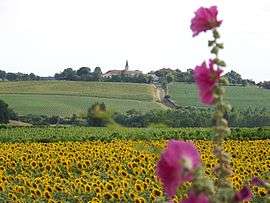 A general view of Lagraulet-du-Gers | |
Location of Lagraulet-du-Gers 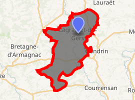
| |
 Lagraulet-du-Gers  Lagraulet-du-Gers | |
| Coordinates: 43°54′16″N 0°12′48″E | |
| Country | France |
| Region | Occitanie |
| Department | Gers |
| Arrondissement | Condom |
| Canton | Armagnac-Ténarèze |
| Government | |
| • Mayor (2008–2014) | Nicolas Meliet |
| Area 1 | 27.22 km2 (10.51 sq mi) |
| Population (2017-01-01)[1] | 575 |
| • Density | 21/km2 (55/sq mi) |
| Time zone | UTC+01:00 (CET) |
| • Summer (DST) | UTC+02:00 (CEST) |
| INSEE/Postal code | 32180 /32330 |
| Elevation | 85–186 m (279–610 ft) |
| 1 French Land Register data, which excludes lakes, ponds, glaciers > 1 km2 (0.386 sq mi or 247 acres) and river estuaries. | |
Geography
The Auzoue flows north through the middle of the commune.
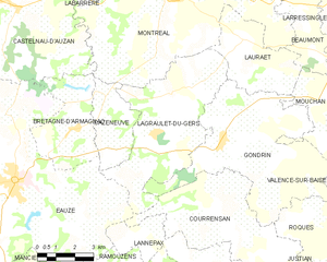
Lagraulet-du-Gers and its surrounding communes
Population
| Year | Pop. | ±% |
|---|---|---|
| 1962 | 575 | — |
| 1968 | 545 | −5.2% |
| 1975 | 410 | −24.8% |
| 1982 | 427 | +4.1% |
| 1990 | 395 | −7.5% |
| 1999 | 381 | −3.5% |
| 2008 | 399 | +4.7% |
gollark: What? No, we optimize to arbitrary depth in all parallel universes and timelines simultaneously.
gollark: Anyway, if you still use embodied employees, that might explain why UCorp™ is so behind.
gollark: The measures are of course autooptimized too.
gollark: Our cluster management systems just automatically select for productivity.
gollark: See, wage growth cost us capital which could otherwise be fed to our capital generators, so we just use orbital mind control laser backscatter to nondestructively extract neural patterns from arbitrary people, then execute them in parallel at a few thousand times real time speed on our computing clusters.
See also
References
- "Populations légales 2017". INSEE. Retrieved 6 January 2020.
| Wikimedia Commons has media related to Lagraulet-du-Gers. |
| Authority control |
|
|---|
This article is issued from Wikipedia. The text is licensed under Creative Commons - Attribution - Sharealike. Additional terms may apply for the media files.