Estampes, Gers
Estampes is a commune in the Gers department in southwestern France.
Estampes | |
|---|---|
.JPG) The church in Estampes | |
.svg.png) Coat of arms | |
Location of Estampes 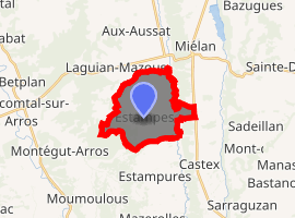
| |
 Estampes  Estampes | |
| Coordinates: 43°23′53″N 0°16′37″E | |
| Country | France |
| Region | Occitanie |
| Department | Gers |
| Arrondissement | Mirande |
| Canton | Mirande-Astarac |
| Intercommunality | Hautes vallées de Gascogne |
| Government | |
| • Mayor (2008–2014) | Francis Durot |
| Area 1 | 10.82 km2 (4.18 sq mi) |
| Population (2017-01-01)[1] | 159 |
| • Density | 15/km2 (38/sq mi) |
| Time zone | UTC+01:00 (CET) |
| • Summer (DST) | UTC+02:00 (CEST) |
| INSEE/Postal code | 32126 /32170 |
| Elevation | 203–339 m (666–1,112 ft) (avg. 259 m or 850 ft) |
| 1 French Land Register data, which excludes lakes, ponds, glaciers > 1 km2 (0.386 sq mi or 247 acres) and river estuaries. | |
Geography
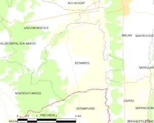
Estampes and its surrounding communes
Population
| Year | Pop. | ±% |
|---|---|---|
| 1962 | 289 | — |
| 1968 | 274 | −5.2% |
| 1975 | 237 | −13.5% |
| 1982 | 207 | −12.7% |
| 1990 | 189 | −8.7% |
| 1999 | 173 | −8.5% |
| 2008 | 170 | −1.7% |
gollark: Oh, and you want it to be the ONLY thing?
gollark: You do NOT want to know about Microsoft's VisualBasic HTML.
gollark: That was already tried, actually. JavaScript is the least bad result to come out of meddling with the development of web scripting via time travel.
gollark: Without type theory, the world would be in a PERPETUAL HELLSCAPE of JAVASCRIPT.
gollark: You are wrong. Type theory is important and useful.
See also
References
- "Populations légales 2017". INSEE. Retrieved 6 January 2020.
| Wikimedia Commons has media related to Estampes (Gers). |
| Authority control |
|
|---|
This article is issued from Wikipedia. The text is licensed under Creative Commons - Attribution - Sharealike. Additional terms may apply for the media files.