Fourcès
Fourcès is a commune in the Gers department in the Occitanie region in southwestern France known for its circular place.
Fourcès | |
|---|---|
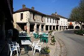 The village of Fourcès | |
.svg.png) Coat of arms | |
Location of Fourcès 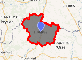
| |
 Fourcès  Fourcès | |
| Coordinates: 43°59′38″N 0°13′51″E | |
| Country | France |
| Region | Occitanie |
| Department | Gers |
| Arrondissement | Condom |
| Canton | Armagnac-Ténarèze |
| Government | |
| • Mayor (2008–2014) | Daniel Bellot |
| Area 1 | 23.72 km2 (9.16 sq mi) |
| Population (2017-01-01)[1] | 260 |
| • Density | 11/km2 (28/sq mi) |
| Time zone | UTC+01:00 (CET) |
| • Summer (DST) | UTC+02:00 (CEST) |
| INSEE/Postal code | 32133 /32250 |
| Elevation | 64–180 m (210–591 ft) (avg. 65 m or 213 ft) |
| 1 French Land Register data, which excludes lakes, ponds, glaciers > 1 km2 (0.386 sq mi or 247 acres) and river estuaries. | |
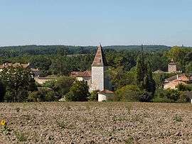
View of Fourcès
Geography
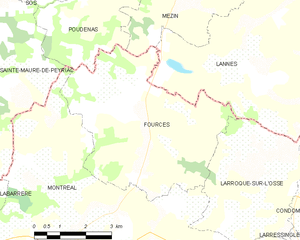
Fourcès lies near Castelnau-d'Auzan and Montréal.
The Auzoue flows north through the middle of the commune. The village lies in the middle of the commune, on the left bank of the Auzoue.
Fourcès and its surrounding communes
Population
| Year | Pop. | ±% |
|---|---|---|
| 1962 | 532 | — |
| 1968 | 468 | −12.0% |
| 1975 | 372 | −20.5% |
| 1982 | 356 | −4.3% |
| 1990 | 324 | −9.0% |
| 1999 | 277 | −14.5% |
| 2008 | 290 | +4.7% |
Sights
Fourcès is a typical medieval bastide, a little village where the houses are built in a circle to allow a proper defence.
The following are notable sights:
- The arena for the course Landaise for example in Castelnau-d'Auzan.
- Old Armagnac caves.
- The bastide of Bretagne-d'Armagnac.
- The Bastide Gasconne of Fourcès.
- The city of Montréal-du-Gers with a medieval bastide.
- The city of Eauze and its Roman treasure.
- The fortified village of Larressingle.
- The Gallo-Roman villa of Séviac, in Montréal-du-Gers.
- The Ganaderia de Buros.
- The museum of D'Artagnan in Lupiac.
- The Spa of Barbotan-les-Thermes in Cazaubon.
gollark: Yes, there's lots of interesting discussion.
gollark: I'm on desktop. It is not good on that.
gollark: Oh no. I accidentally refreshed the page, and now I am experiencing the horrors of the new UI.
gollark: I haven't actually personally experienced it, but apparently here in the UK the government handles the usual tax arrangements automatically instead of making you fill out all the paperwork, which seems good.
gollark: ÿ́ͦ̐ǒ̆̍uͣ̋ͬr̊͐ͤeͣ̇ͣ
See also
External links
| Wikimedia Commons has media related to Fourcès. |
- Location of the commune (map with scale 1:100.000) on Mapquest
- More statistical information concerning the commune on www.insee.fr
| Authority control |
|
|---|
This article is issued from Wikipedia. The text is licensed under Creative Commons - Attribution - Sharealike. Additional terms may apply for the media files.