Grade II* listed buildings in Vale of White Horse
There are over 20,000 Grade II* listed buildings in England. This page is a list of these buildings in the district of Vale of White Horse in Oxfordshire.
List of buildings
| Name | Location | Type | Completed [note 1] | Date designated | Grid ref.[note 2] Geo-coordinates |
Entry number [note 3] | Image |
|---|---|---|---|---|---|---|---|
| Stratton House | Abingdon | House | 1722 | 10 December 1971 | SU4961597209 51°40′17″N 1°17′02″W |
1048924 |  |
| Stratton Lodge | Abingdon | House | c.1800 | 19 January 1951 | SU4960897219 51°40′18″N 1°17′03″W |
1183402 | |
| The Clock House | Abingdon | House | 1722 | 19 January 1951 | SU4950097031 51°40′12″N 1°17′08″W |
1368304 | .jpg) The Clock House |
| The Knowl | Abingdon | House | 16th century | 19 January 1951 | SU4975697268 51°40′19″N 1°16′55″W |
1283160 | .jpg) The Knowl |
| Tomkins Almshouses | Abingdon | Almshouses | Founded 1733 | 19 January 1951 | SU4928397016 51°40′11″N 1°17′20″W |
1368299 | 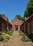 Tomkins Almshouses |
| Twickenham House (20 East St Helen Street) | Abingdon | House | Mid-18th century | 19 January 1951 | SU4976096954 51°40′09″N 1°16′55″W |
1368281 | 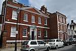 Twickenham House (20 East St Helen Street) |
| Railings to No 20, East St Helen Street | Abingdon | Railings and lamp holder | 10 December 1971 | SU4975496954 51°40′09″N 1°16′55″W |
1048904 | 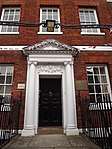 Railings to No 20, East St Helen Street | |
| Stables to No 20 including cobbled yard | Abingdon | Stables | Mid-18th century | 10 December 1971 | SU4977396969 51°40′09″N 1°16′54″W |
1199451 | |
| Wall and gatepiers to Stables at No 20 | Abingdon | Wall and gate | 10 December 1971 | SU4975696970 51°40′10″N 1°16′55″W |
1368282 | | |
| 26 and 26a East St Helen St | Abingdon | House | C. late 16th or early 17th century | 19 January 1951 | SU4975396929 51°40′08″N 1°16′55″W |
1048906 | 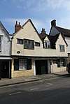 26 and 26a East St Helen St |
| 28 East St Helen St | Abingdon | House | Early 18th century | 19 January 1951 | SU4975296917 51°40′08″N 1°16′55″W |
1283371 | 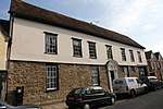 28 East St Helen St |
| 57 East St Helen Street | Abingdon | House | 1732 | 19 January 1951 | SU4971496871 51°40′06″N 1°16′57″W |
1199427 | .jpg) 57 East St Helen Street |
| Appleton Manor | Appleton | House | c.1190–1200 | 6 August 1952 | SP4435601510 51°42′38″N 1°21′34″W |
1198061 | 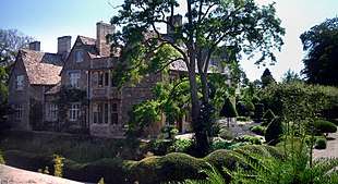 Appleton Manor |
| Church of St Lawrence | Appleton | Church | Late 12th century | 9 February 1966 | SP4439401545 51°42′39″N 1°21′32″W |
1048421 | 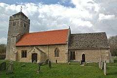 Church of St Lawrence |
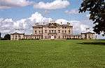
| Ardington House | Ardington | Country house | c.1720 | 25 October 1951 | SU4329588273 51°35′30″N 1°22′35″W |
1048188 | 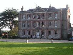 Ardington House |
| Church of the Holy Trinity | Ardington | Church | 12th century | 24 November 1966 | SU4315688319 51°35′31″N 1°22′42″W |
1048189 | 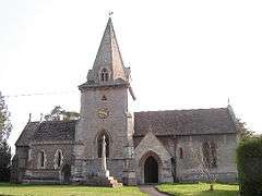 Church of the Holy Trinity |
| The Manor House | Ashbury | Manor house | c.1488 | 21 November 1966 | SU2631685228 51°33′55″N 1°37′18″W |
1368375 | 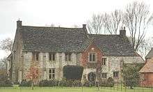 The Manor House |
| Church of St Lawrence | Besselsleigh | Church | Early 12th century | 9 February 1966 | SP4563101073 51°42′24″N 1°20′28″W |
1048397 | 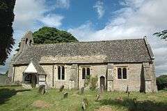 Church of St Lawrence |
| Buckland House | Buckland | Country house | c.1757 | 21 November 1966 | SU3405298212 51°40′54″N 1°30′32″W |
1368380 | |
| Home Farm Dovecote | Buckland | Dovecote | 1755–57 | 15 January 1986 | SU3406396708 51°40′05″N 1°30′32″W |
1048686 | 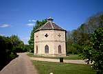 Home Farm Dovecote |
| Ice house about 270m north east of Buckland House | Buckland | Icehouse | c.1757 | 15 January 1986 | SU3425098399 51°41′00″N 1°30′22″W |
1284798 | |
| Manor House | Buckland | Country house | c.1580 | 10 November 1952 | SU3426298258 51°40′55″N 1°30′21″W |
1284800 | 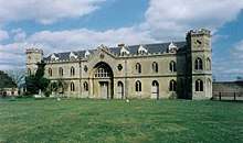 Manor House |
| Buscot Park | Buscot | Country house | c.1780 | 10 November 1952 | SU2430696829 51°40′11″N 1°39′00″W |
1368116 | |
| Manor Farmhouse | Buscot | Farmhouse | 1691 | 10 November 1952 | SU2304197720 51°40′40″N 1°40′05″W |
1181672 | 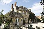 Manor Farmhouse |
| The Old Parsonage | Buscot | Vicarage | 1703 | 10 November 1952 | SU2259698147 51°40′54″N 1°40′28″W |
1052711 | .jpg) The Old Parsonage |
| Place Farm House | Chilton | Farmhouse | 15th century | 7 May 1976 | SU4908885822 51°34′09″N 1°17′35″W |
1199600 | |
| Church of All Saints | Coleshill | Church | Late 12th century | 21 November 1966 | SU2354693776 51°38′32″N 1°39′40″W |
1368120 | 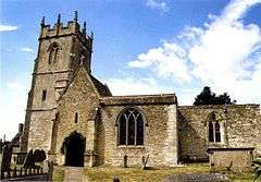 Church of All Saints |
| Coleshill Park, northern pair of piers on the drive about 40m south east of gate lodge | Coleshill | Gatepiers | 17th century | 10 November 1952 | SU2398393837 51°38′34″N 1°39′17″W |
1284579 | |
| Coleshill Park, northern pair of piers about 15m south east of clock house | Coleshill | Gatepiers | 17th century | 10 November 1952 | SU2394893769 51°38′32″N 1°39′19″W |
1052694 | |
| Coleshill Park, southern pair of piers on the drive, about 40m south east of gate lodge | Coleshill | Gatepiers | 17th century | 10 November 1952 | SU2398093834 51°38′34″N 1°39′17″W |
1052693 | |
| Coleshill Park, southern pair of piers about 15m south east of clock house | Coleshill | Gatepiers | 17th century | 10 November 1952 | SU2394293765 51°38′32″N 1°39′19″W |
1284553 | |
| Courtleaze Farm buildings and attached gatepiers and rickyard walls | Coleshill | Farm buildings | c.1850–54 | 23 November 1990 | SU2353193562 51°38′25″N 1°39′41″W |
1052663 | 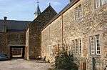 Courtleaze Farm buildings and attached gatepiers and rickyard walls |
| The Old Rectory | Coleshill | House | 14th–19th century | 10 November 1952 | SU2365593805 51°38′33″N 1°39′34″W |
1052689 | |
| Church of St Swithun | Compton Beauchamp | Church | Late 13th century | 21 November 1966 | SU2792386919 51°34′50″N 1°35′54″W |
1198176 | 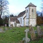 Church of St Swithun |
| Compton Beauchamp House: gates, gatepiers and walls about 35m north | Compton Beauchamp | Gatepiers | c.1710 | 10 November 1952 | SU2799286982 51°34′52″N 1°35′51″W |
1283938 | 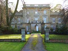 Compton Beauchamp House: gates, gatepiers and walls about 35m north |
| Compton Beauchamp House: gates, gatepiers and walls about 200m south | Compton Beauchamp | Gate | c.1710 | 11 December 1985 | SU2792986759 51°34′44″N 1°35′54″W |
1198250 | |
| Bear and Ragged Staff Inn | Cumnor | Farmhouse | Early 17th century | 6 August 1952 | SP4591004094 51°44′01″N 1°20′12″W |
1368591 | 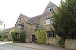 Bear and Ragged Staff Inn |
| Swinford Bridge (that part in Cumnor) | Cumnor | Bridge | 1767 | 9 February 1966 | SP4430708608 51°46′28″N 1°21′33″W |
1284764 | 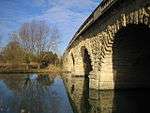 Swinford Bridge (that part in Cumnor) |
| Church of St James | Denchworth | Church | Late 12th century | 24 November 1966 | SU3810891714 51°37′23″N 1°27′03″W |
1048582 | 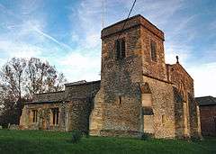 Church of St James |
| Denchworth Manor | Denchworth | House | Late 16th/early 17th century | 25 October 1951 | SU3824891754 51°37′24″N 1°26′56″W |
1048583 | |
| Church of Saint Peter | Drayton | Church | c.1200 | 9 February 1966 | SU4804994140 51°38′38″N 1°18′25″W |
1052771 | 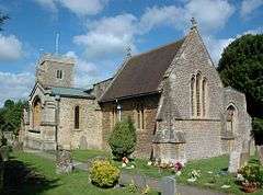 Church of Saint Peter |
| The Manor House | Drayton | Manor house | Mid-15th century | 6 August 1952 | SU4823094063 51°38′36″N 1°18′16″W |
1052737 | 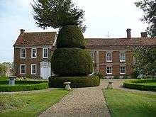 The Manor House |
| Church of St Nicholas | East Challow | Church | Mid-/late 13th century | 24 November 1966 | SU3807888253 51°35′31″N 1°27′06″W |
1048593 | 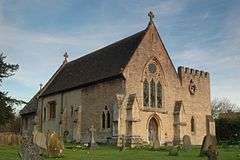 Church of St Nicholas |
| Church of St Augustine of Canterbury | East Hendred | Church | 12th century | 24 November 1966 | SU4593188614 51°35′40″N 1°20′18″W |
1048169 | 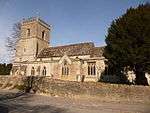 Church of St Augustine of Canterbury |
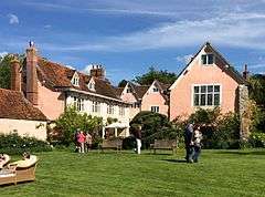
| Hendred House and St Amands Chapel | East Hendred | Cross-wing house | Early 15th century | 25 October 1951 | SU4609288635 51°35′41″N 1°20′10″W |
1368665 | 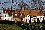 Hendred House and St Amands Chapel |
| Church of St Michael | Eaton Hastings | Church | 13th century | 21 November 1966 | SU2628198558 51°41′07″N 1°37′16″W |
1182735 | 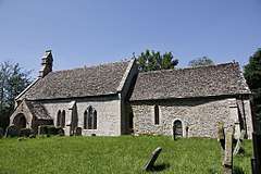 Church of St Michael |
| Church of St Nicholas | Fyfield | Church | c.1200 | 9 February 1966 | SU4234198904 51°41′14″N 1°23′20″W |
1368546 | 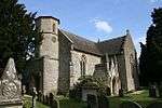 Church of St Nicholas |
| Manor Farmhouse | Fyfield | Farmhouse | c.1700 | 9 February 1966 | SU4227198842 51°41′12″N 1°23′24″W |
1048366 | 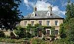 Manor Farmhouse |
| The Manor House | Fyfield | Manor house | c.1325 | 6 August 1952 | SU4230798943 51°41′16″N 1°23′22″W |
1198429 | .jpg) The Manor House |
| The White Hart Inn | Fyfield | Open-hall house | Mid-15th century, after 1442 | 6 August 1952 | SU4235698760 51°41′10″N 1°23′19″W |
1048407 | |
| Church of All Saints | Goosey | Church | Early/mid-13th century | 24 November 1966 | SU3563891654 51°37′21″N 1°29′12″W |
1368468 | 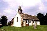 Church of All Saints |
| Church of St Giles | Great Coxwell | Church | 13th century | 21 November 1966 | SU2698993424 51°38′20″N 1°36′41″W |
1368112 | 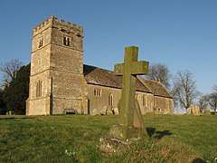 Church of St Giles |
| Old Town Hall | Great Faringdon | Town hall | Late 17th or early 18th century | 12 February 1958 | SU2888195578 51°39′30″N 1°35′02″W |
1048440 | .jpg) Old Town Hall |
| Sudbury House | Great Faringdon | House | 18th century | 10 November 1952 | SU2933595626 51°39′31″N 1°34′38″W |
1368525 | |
| Cherry Barn and attached outbuildings, about 5m east of Bayllols Manor | Harwell | Hall house | c.1350 | 25 October 1951 | SU4919289339 51°36′03″N 1°17′28″W |
1368642 | |
| Cruck barn about 40m east of Bayllols Manor | Harwell | Cruck barn | c.1365 | 24 November 1966 | SU4923689372 51°36′04″N 1°17′26″W |
1048206 | |
| Gable Cottage and Tibbleton Cottage | Harwell | House | Late 17th century | 5 May 1988 | SU4916888872 51°35′48″N 1°17′30″W |
1048218 | |
| Geering's Almshouses and attached walls and gate | Harwell | Gate | c.1723 | 25 October 1951 | SU4916389167 51°35′57″N 1°17′30″W |
1368639 |  Geering's Almshouses and attached walls and gate |
| Lime Tree House | Harwell | House | 17th century | 24 November 1966 | SU4911489121 51°35′56″N 1°17′32″W |
1199929 | |
| The Manor House | Hatford | House | Late 17th century | 10 November 1952 | SU3368994804 51°39′04″N 1°30′52″W |
1048640 | |
| The Old Church of St George | Hatford | Church | Mid-12th century | 21 November 1966 | SU3371994817 51°39′04″N 1°30′50″W |
1284666 | 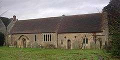 The Old Church of St George |
| Church of St Margaret | Hinton Waldrist | Church | Mid-13th century | 21 November 1966 | SU3751399104 51°41′22″N 1°27′31″W |
1048641 | 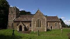 Church of St Margaret |
| Hinton Manor | Hinton Waldrist | House | Late 16th century | 10 November 1952 | SU3744499163 51°41′24″N 1°27′35″W |
1182212 | |
| The Old Rectory and Old Rectory Cottage | Hinton Waldrist | House | 14th–19th century | 15 January 1986 | SU3757699145 51°41′23″N 1°27′28″W |
1368397 | |
| Kennington Manor House and attached wall and gatepiers | Kennington | Farmhouse | Late 18th century | 6 August 1952 | SP5233702356 51°43′03″N 1°14′38″W |
1182054 | |
| Gazebo, terrace walls, gates, gatepiers and wall 74m north west of Kingston House | Kingston Bagpuize with Southmoor | Gazebo | Early 18th century | 6 August 1952 | SU4079997986 51°40′45″N 1°24′41″W |
1048380 | .jpg) Gazebo, terrace walls, gates, gatepiers and wall 74m north west of Kingston House |
| Kingston House | Kingston Bagpuize with Southmoor | Country house | 17th century | 6 August 1952 | SU4072897913 51°40′43″N 1°24′44″W |
1198912 | .jpg) Kingston House |
| New Bridge and flanking walls (that part in Kingston Bagpuize civil parish) | Kingston Bagpuize with Southmoor | Bridge | 14th century and later | 9 February 1966 | SP4036401387 51°42′35″N 1°25′02″W |
1048348 | 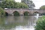 New Bridge and flanking walls (that part in Kingston Bagpuize civil parish) |
| Church of St John the Baptist | Kingston Lisle | Church | c.1200 | 21 November 1966 | SU3261887622 51°35′11″N 1°31′50″W |
1048718 | 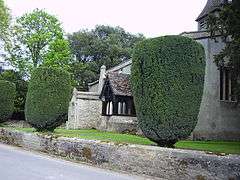 Church of St John the Baptist |
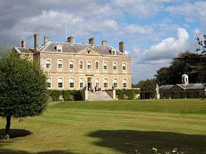
| Kingston Lisle Park | Kingston Lisle | Country house | 1677 | 10 November 1952 | SU3264587500 51°35′07″N 1°31′49″W |
1048722 | |
| Church of St Michael | Letcombe Bassett | Church | 12th century | 24 November 1966 | SU3737884919 51°33′43″N 1°27′44″W |
1253889 | 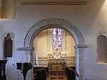 Church of St Michael |
| The Old Rectory, barn about 15m south east | Letcombe Bassett | Barn | 14th century | 11 December 1985 | SU3748284967 51°33′44″N 1°27′38″W |
1048731 | |
| Church of St Andrew | Letcombe Regis | Church | 12th century | 24 November 1966 | SU3802586474 51°34′33″N 1°27′10″W |
1368706 | 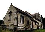 Church of St Andrew |
| Church of St Mary | Little Coxwell | Church | Transitional | 21 November 1966 | SU2819093534 51°38′24″N 1°35′39″W |
1048820 | 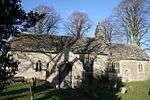 Church of St Mary |
| Church of All Saints | East Lockinge | Church | 12th century | 24 November 1966 | SU4282087204 51°34′55″N 1°23′00″W |
1368679 | 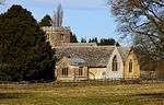 Church of All Saints |
| Church of St Mary | Longcot | Church | 13th century | 21 November 1966 | SU2739690718 51°36′53″N 1°36′21″W |
1048781 | 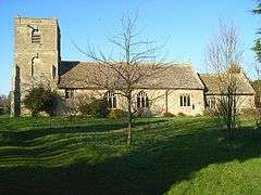 Church of St Mary |
| Longcot House | Longcot | House | c.1703 | 21 November 1966 | SU2766090939 51°37′00″N 1°36′07″W |
1048786 | .jpg) Longcot House |
| Tithe Barn | Longworth | Tithe barn | 17th century | 19 July 1999 | SU3870698196 51°40′52″N 1°26′30″W |
1387458 | |
| Church of St Mary | Lyford | Church | Early 13th century | 9 February 1966 | SU3901194230 51°38′44″N 1°26′15″W |
1199327 | 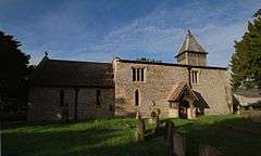 Church of St Mary |
| Lyford Grange | Lyford | House | c.1430–80 | 9 February 1966 | SU3961794531 51°38′53″N 1°25′44″W |
1283468 | |
| Church of All Saints | Marcham | Church | Early 13th century | 9 February 1966 | SU4520496814 51°40′06″N 1°20′52″W |
1048354 | 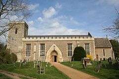 Church of All Saints |
| Hyde Farmhouse | Marcham | Farmhouse | Circa mid-16th century | 12 February 1987 | SU4596796838 51°40′06″N 1°20′12″W |
1368562 | |
| The Priory about 10m south of Marcham Priory (not included) | Marcham | House | Mid-16th century | 6 August 1952 | SU4567196434 51°39′53″N 1°20′28″W |
1199599 |  The Priory about 10m south of Marcham Priory (not included) |
| Church of St Blaise | Milton | Church | 14th century | 9 February 1966 | SU4853692417 51°37′43″N 1°18′01″W |
1368648 | 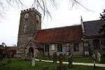 Church of St Blaise |
| 42a and 42b High Street | Milton | Jettied house | Early 14th century | 5 May 1988 | SU4856692362 51°37′41″N 1°17′59″W |
1300905 | 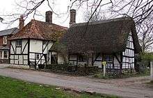 42a and 42b High Street |
| Church of St Lawrence | North Hinksey | Church | Early 12th century | 9 February 1966 | SP4948305479 51°44′45″N 1°17′05″W |
1182110 | 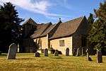 Church of St Lawrence |
| Churchyard cross approximately 15 metres south of Church of St Lawrence | North Hinksey | Cross | 15th century | 9 February 1966 | SP4950505470 51°44′45″N 1°17′04″W |
1048318 | 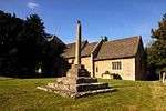 Churchyard cross approximately 15 metres south of Church of St Lawrence |
| Well house, approximately 160 metres south-east of The Fold | North Hinksey | Well house | 1610 | 9 February 1966 | SP4952405048 51°44′31″N 1°17′03″W |
1048315 | 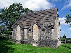 Well house, approximately 160 metres south-east of The Fold |
| Church of All Saints | Pusey | Church | 1745–50 | 21 November 1966 | SU3604996526 51°39′59″N 1°28′49″W |
1368423 | 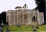 Church of All Saints |
| Pusey House | Pusey | Country house | c.1750 | 10 November 1952 | SU3592296762 51°40′07″N 1°28′55″W |
1048628 | 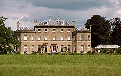 Pusey House |
| Chapel | St Peters College, Radley | Chapel | 1893–94 | 24 June 1987 | SU5183799505 51°41′31″N 1°15′05″W |
1368608 | 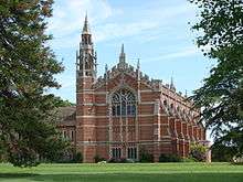 Chapel |
| Church of St James | Radley | Church | 13th century | 9 February 1966 | SU5219499377 51°41′27″N 1°14′47″W |
1048324 | 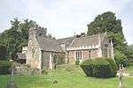 Church of St James |
| Radley Hall | St Peters College, Radley | Country House | 1721–27 | 9 February 1966 | SU5178299546 51°41′32″N 1°15′08″W |
1182496 | 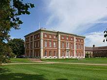 Radley Hall |
| Wick Hall and attached walls | Radley | House | c.1720 | 9 February 1966 | SU5166097974 51°40′41″N 1°15′15″W |
1284611 | |
| Holywell House | Shellingford | House | Mid-17th century | 15 January 1986 | SU3174893706 51°38′29″N 1°32′33″W |
1182685 | |
| Elm Tree House | Shrivenham | House | c.1700 | 10 November 1952 | SU2404688970 51°35′57″N 1°39′15″W |
1183075 | 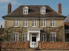 Elm Tree House |
| Church of St Laurence | South Hinksey | Church | Early/mid-13th century | 9 February 1966 | SP5097303969 51°43′56″N 1°15′48″W |
1048297 | 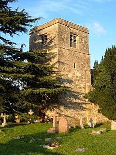 Church of St Laurence |
| Barn about 20m north east of the Manor Preparatory School | Shippon, St. Helen Without | Barn | 15th century | 9 February 1966 | SU4846698045 51°40′45″N 1°18′02″W |
1048303 | |
| Cox's Hall | Stanford in the Vale | House | 1739 | 10 November 1952 | SU3405693116 51°38′09″N 1°30′34″W |
1048611 | .jpg) Cox's Hall |
| Wall about 15m south of Cox's Hall | Stanford in the Vale | Gatepier | c.1739 | 15 January 1986 | SU3406293085 51°38′08″N 1°30′33″W |
1048577 | Wall about 15m south of Cox's Hall |
| Orchard House | Stanford in the Vale | House | 1635 | 10 November 1952 | SU3435393438 51°38′19″N 1°30′18″W |
1368473 |  Orchard House |
| The Manor House and Manor Cottage | Stanford in the Vale | Farmhouse | 16th/early 18th century | 10 November 1952 | SU3421893403 51°38′18″N 1°30′25″W |
1368451 | |
| Home Farmhouse | Steventon | Farmhouse | 14th century | 9 February 1966 | SU4729392027 51°37′30″N 1°19′06″W |
1052749 | |
| Priory Cottage | Steventon | House | c.1463 | 6 August 1952 | SU4655891503 51°37′14″N 1°19′44″W |
1052724 |  Priory Cottage |
| Raised Causeway | Steventon | Causeway | 14th century | 19 February 1988 | SU4665191649 51°37′18″N 1°19′39″W |
1052720 |  Raised Causeway |
| Raised Causeway | Steventon | Causeway | 14th century | 19 February 1988 | SU4688691845 51°37′25″N 1°19′27″W |
1368076 |  Raised Causeway |
| Raised Causeway | Steventon | Causeway | 14th century | 19 February 1988 | SU4728892062 51°37′31″N 1°19′06″W |
1368074 |  Raised Causeway |
| Tudor House | Steventon | House | Mid-17th century | 6 August 1952 | SU4675791739 51°37′21″N 1°19′34″W |
1052721 | 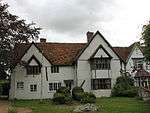 Tudor House |
| 39 The Causeway | Steventon | House | 15th century | 6 August 1952 | SU4698691864 51°37′25″N 1°19′22″W |
1052753 | 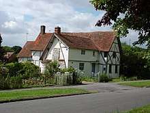 39 The Causeway |
| 83 and 85 The Causeway | Steventon | House | 15th century | 6 August 1952 | SU4669191673 51°37′19″N 1°19′37″W |
1052723 | 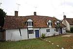 83 and 85 The Causeway |
| Church of St Leonard | Sunningwell | Church | 13th century | 9 February 1966 | SP4957200532 51°42′05″N 1°17′03″W |
1182736 | 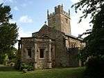 Church of St Leonard |
| The Old Manor | Sunningwell | House | Early 17th century | 6 August 1952 | SP4974700660 51°42′09″N 1°16′54″W |
1368593 |  The Old Manor |
| Buckeridges | Sutton Courtenay | Timber-framed house | 1631 | 6 August 1952 | SU5018793850 51°38′28″N 1°16′34″W |
1052701 | |
| Chest tomb about 10m south of chancel of Church of All Saints | Sutton Courtenay | Chest Tomb | 15th century | 19 February 1988 | SU5048894175 51°38′39″N 1°16′18″W |
1368103 | 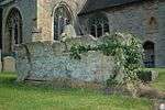 Chest tomb about 10m south of chancel of Church of All Saints |
| East gatepier about 20m south east of the Manor House | Sutton Courtenay | Gatepier | c.1670 | 6 August 1952 | SU5024694134 51°38′38″N 1°16′31″W |
1052733 | |
| Outbuilding about 15m north east of the Manor House | Sutton Courtenay | Banqueting house | 16th century | 6 August 1952 | SU5025594160 51°38′38″N 1°16′30″W |
1182341 | |
| The Manor House | Sutton Courtenay | Cruck house | 12th century | 6 August 1952 | SU5023094140 51°38′38″N 1°16′32″W |
1052732 | |
| West gatepier approximately 20 metres south east of the Manor House | Sutton Courtenay | Gatepier | c.1670 | 6 August 1952 | SU5024194129 51°38′37″N 1°16′31″W |
1052734 | |
| Church of St Mary | Upton | Church | 12th century | 24 November 1966 | SU5148987002 51°34′46″N 1°15′30″W |
1200134 |  Church of St Mary |
| Ham House | Wantage | House | c.1740 | 22 April 1950 | SU3904087434 51°35′04″N 1°26′17″W |
1368457 | |
| 32 and 33 Market Place | Wantage | Town house | c.1700 | 22 April 1950 | SU3977187928 51°35′20″N 1°25′38″W |
1048552 |  32 and 33 Market Place |
| Church of St Laurence | West Challow | Church | Late 12th century | 24 November 1966 | SU3666688328 51°35′33″N 1°28′20″W |
1052756 | 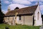 Church of St Laurence |
| Church of St James | West Hanney | Church | c.1150 | 24 November 1966 | SU4061992800 51°37′57″N 1°24′52″W |
1300859 | 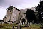 Church of St James |
| West Hanney House and attached archways | West Hanney | Vicarage | 1727 | 25 October 1951 | SU4058492888 51°38′00″N 1°24′54″W |
1300843 | 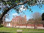 West Hanney House and attached archways |
| Church of All Saints | Woolstone | Church | c.1200 | 21 November 1966 | SU2943987599 51°35′11″N 1°34′35″W |
1199074 | 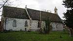 Church of All Saints |
gollark: Oh bee oh apioform. Tom Scott CANNOT be incorrect.
gollark: Under the FSG™ system, you have to explicitly register an idea, and when you do so it is erased entirely from everyone else's mind via our nanobot networks.
gollark: zeroth
gollark: Says an untrustworthy falsehood octachoron™.
gollark: If I don't license a software project, it is under "all rights reserved".
See also
Notes
- The date given is the date used by Historic England as significant for the initial building or that of an important part in the structure's description.
- Sometimes known as OSGB36, the grid reference is based on the British national grid reference system used by the Ordnance Survey.
- The "List Entry Number" is a unique number assigned to each listed building and scheduled monument by Historic England.
External links
![]()
This article is issued from Wikipedia. The text is licensed under Creative Commons - Attribution - Sharealike. Additional terms may apply for the media files.