Grade II* listed buildings in Amber Valley
There are over 20,000 Grade II* listed buildings in England. This page is a list of these buildings in the district of Amber Valley in Derbyshire.
List of buildings
| Name | Location | Type | Completed [note 1] | Date designated | Grid ref.[note 2] Geo-coordinates |
Entry number [note 3] | Image |
|---|---|---|---|---|---|---|---|
| Church of St Martin | Alfreton | Church | 19th century | 13 July 1966 | SK4073155885 53°05′55″N 1°23′35″W |
1335406 | 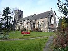 Church of St Martin |
| Belper river weirs, retaining walls and sluices to Belper river veirs | Bridge Foot, Belper | Weir | 1796–97 | 3 February 1966 | SK3454048170 53°01′47″N 1°29′11″W |
1335702 | 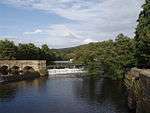 Belper river weirs, retaining walls and sluices to Belper river veirs |
| Road archway and footbridge (includes offices forming south part of block in east side of archway) | Bridge Foot, Belper | Footbridge | Late 18th–early 19th century | 3 February 1966 | SK3453748036 53°01′43″N 1°29′11″W |
1087395 | 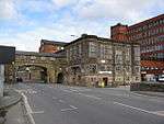 Road archway and footbridge (includes offices forming south part of block in east side of archway) |
| Mills occupied by George Brettle and Company Limited (that part along the Chapel Street frontage, bounded on the north by the 1834 building, including northern rear wing, and, on the south, by the recessed, single-storey red-brick building) | Belper | Mill | Early–mid-19th century | 3 February 1966 | SK3465947298 53°01′19″N 1°29′05″W |
1087409 |  Mills occupied by George Brettle and Company Limited (that part along the Chapel Street frontage, bounded on the north by the 1834 building, including northern rear wing, and, on the south, by the recessed, single-storey red-brick building) |
| Crossroads Farmhouse | Belper | Farmhouse | Early 19th century | 3 February 1966 | SK3364247869 53°01′37″N 1°29′59″W |
1087421 | .jpg) Crossroads Farmhouse |
| North wing of Dalley Farmhouse | Belper | Farmhouse | 17th century | 30 December 1979 | SK3368248096 53°01′45″N 1°29′57″W |
1087426 | .jpg) North wing of Dalley Farmhouse |
| East and south boundary walls to eastern farmyard at Dalley Farm, north and west boundary walls and stone steps to farm complex | Belper | Boundary wall | Early 19th century | 13 December 1979 | SK3365148186 53°01′48″N 1°29′59″W |
1087427 |  |
| Stable range and carriageway entrance dividing east and west farmyards at Dalley Farm | Belper | Stable | Early 19th century | 13 December 1979 | SK3369248082 53°01′44″N 1°29′57″W |
1087428 | |
| Range of farm buildings fronting north side of east and west farmyards at Dalley Farm | Belper | Farm buildings | Early 19th century | 13 December 1979 | SK3371048103 53°01′45″N 1°29′56″W |
1087429 | |
| Range of farm buildings forming western side of west farmyard at Dalley Farm | Belper | Farm buildings | Early 19th century | 13 December 1979 | SK3367548080 53°01′44″N 1°29′58″W |
1087430 | |
| Northeastern range of farm buildings at Dalley Farm (L-shaped range including northern hay barn, corner cart shed and shelter shed at lower level | Belper | Farm buildings | 19th century | 13 December 1979 | SK3372348126 53°01′46″N 1°29′55″W |
1087431 | |
| Moscow Farmhouse | Milford, Belper | Farmhouse | 1812–15 | 13 December 1979 | SK3467044478 52°59′47″N 1°29′06″W |
1335721 | |
| Ranges to east of house at Moscow Farm | Milford, Belper | Farmhouse | unknown | 13 December 1979 | SK3467844468 52°59′47″N 1°29′05″W |
1099936 | |
| Ranges to north, east and west of foldyard at Moscow Farm | Milford, Belper | Farm buildings | unknown | 13 December 1979 | SK3465444465 52°59′47″N 1°29′06″W |
1087352 | |
| Unitarian Chapel and Chapel Cottage | Belper | Chapel | 1689 | 13 December 1979 | SK3496247838 53°01′36″N 1°28′49″W |
1348701 | |
| Church Farmhouse and attached outbuilding | Denby | Farmhouse | Early 17th century | 13 February 1967 | SK3981646461 53°00′50″N 1°24′29″W |
1109127 | |
| Park Hall Farmhouse | Denby | Farmhouse | Early 17th century | 25 September 1951 | SK3815547366 53°01′20″N 1°25′57″W |
1109132 | |
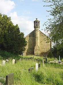
| Church of St John the Baptist | Dethick | Church | 1530 | 13 February 1967 | SK3271457970 53°07′04″N 1°30′46″W |
1373840 | |
| Lea Hall, gatepier, and boundary wall to the north | Dethick | House | 18th century | 13 February 1967 | SK3333357482 53°06′49″N 1°30′12″W |
1109185 | 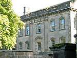 Lea Hall, gatepier, and boundary wall to the north |
| Lea Wood Hall, entrance gatepiers and attached boundary wall | Dethick | Country House | 1874–77 | 26 November 1979 | SK3228156221 53°06′08″N 1°31′10″W |
1109189 | |
| Manor Farmhouse | Dethick | Farmhouse | 18th century | 25 September 1951 | SK3276857980 53°07′05″N 1°30′43″W |
1335316 | |
| Duffield Hall | Duffield | Country house | c.1640 | 13 February 1967 | SK3452943014 52°59′00″N 1°29′14″W |
1158301 | |
| Stone Row | Golden Valley, Ironville | Cottages | Late 18th century | 7 December 1976 | SK4265251296 53°03′26″N 1°21′54″W |
1109007 | 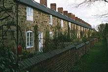 Stone Row |
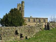
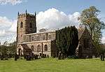
| Church of St Lawrence | Heanor | Church | 15th century | 25 November 1963 | SK4358146440 53°00′49″N 1°21′07″W |
1311460 | 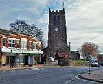 Church of St Lawrence |
| Holbrook Hall | Holbrook | House | 17th century | 13 February 1967 | SK3631144597 52°59′51″N 1°27′38″W |
1335333 | |
| Christ Church | Holloway | Church | 1911 | 14 August 1985 | SK3230056965 53°06′32″N 1°31′08″W |
1335315 | 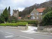 Christ Church |
| South Sitch | Idridgehay and Alton | House | 1621 | 13 February 1967 | SK2881048709 53°02′06″N 1°34′19″W |
1109057 | |
| The Old Rectory and attached stable block | Kedleston | House | 1986 | 24 January 1986 | SK3047241061 52°57′58″N 1°32′52″W |
1335354 | |
| Lion Statue | Kedleston Park | Statue | c.1760–70 by Joseph Wilton | 13 February 1967 | SK3117040236 52°57′31″N 1°32′15″W |
1109087 | 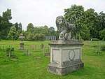 Lion Statue |
| Gothic Temple | Kedleston Park | House | c.1758–59 | 13 February 1967 | SK3187741789 52°58′21″N 1°31′36″W |
1276750 | 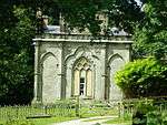 Gothic Temple |
| Monument to Michael Drayton | Kedleston Park | Vase | c.1760–70 | 13 February 1967 | SK3115540231 52°57′31″N 1°32′16″W |
1109086 | 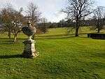 Monument to Michael Drayton |
| The Orangery | Kedleston Park | Orangery | 1800–01 | 13 February 1967 | SK3102840255 52°57′32″N 1°32′22″W |
1109084 | 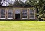 The Orangery |
| The South Lodges | Kedleston Park | Lodges | c.1775 | 13 February 1967 | SK3054141181 52°58′02″N 1°32′48″W |
1311480 |  The South Lodges |
| The Stables | Kedleston Park | Stable | 1768–69 | 13 February 1967 | SK3114240322 52°57′34″N 1°32′16″W |
1109125 | _(geograph_4514473).jpg) The Stables |
| The Sulphur Bath | Kedleston Park | Bath house | 1759–62 | 13 February 1967 | SK3181140531 52°57′40″N 1°31′40″W |
1335353 | 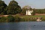 The Sulphur Bath |
| The Summer House | Kedleston Park | Summerhouse | c.1775 | 13 February 1967 | SK3113540197 52°57′30″N 1°32′17″W |
1109085 | 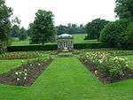 The Summer House |
| Top Farmhouse | Kilburn | Farmhouse | 16th century | 22 August 1980 | SK3788945852 53°00′31″N 1°26′12″W |
1335337 | 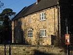 Top Farmhouse |
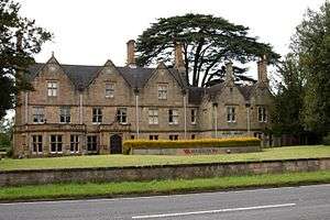
| Kedleston Hotel | Quarndon | Hotel | 1760–62 | 13 February 1967 | SK3262040580 52°57′42″N 1°30′57″W |
1109064 |  Kedleston Hotel |
| Church of St Luke | Heage | Church | 1646–61 | 29 November 1965 | SK3696550627 53°03′06″N 1°27′00″W |
1158964 | |
| Heage Windmill | Heage | Windmill | Early 19th century | 29 November 1965 | SK3669150783 53°03′11″N 1°27′15″W |
1109016 | 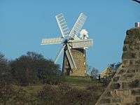 Heage Windmill |
| Furnaces at Morley Park Iron Works | Ripley | Furnace | c.1780 | 29 November 1965 | SK3799849190 53°02′19″N 1°26′05″W |
1108984 | 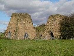 Furnaces at Morley Park Iron Works |
| Padley Hall | Ripley | House | Mid-17th century | 29 November 1965 | SK3946051434 53°03′31″N 1°24′46″W |
1159063 | .jpg) Padley Hall |
| Home Farmhouse and associated farm buildings | Shipley | Farmhouse | 1861 | 14 October 1974 | SK4362944261 52°59′38″N 1°21′05″W |
1335340 | |
| Morley Manor | Smalley | House | 1900 | 20 January 1986 | SK4005642631 52°58′46″N 1°24′18″W |
1109106 | |
| Church of All Saints | South Wingfield | Church | 12th century | 13 February 1967 | SK3832655778 53°05′52″N 1°25′45″W |
1040011 | |
| Crich Stand | Crich | War memorial | 1923 | 15 October 1997 | SK3439455369 53°05′40″N 1°29′16″W |
1072594 | 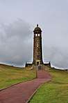 Crich Stand |
See also
- Grade I listed buildings in Derbyshire
- Grade II* listed buildings in Bolsover (district)
- Grade II* listed buildings in Chesterfield
- Grade II* listed buildings in Derby
- Grade II* listed buildings in Derbyshire Dales
- Grade II* listed buildings in Erewash
- Grade II* listed buildings in High Peak
- Grade II* listed buildings in North East Derbyshire
- Grade II* listed buildings in South Derbyshire
Notes
- The date given is the date used by Historic England as significant for the initial building or that of an important part in the structure's description.
- Sometimes known as OSGB36, the grid reference is based on the British national grid reference system used by the Ordnance Survey.
- The "List Entry Number" is a unique number assigned to each listed building and scheduled monument by Historic England.
External links
![]()
This article is issued from Wikipedia. The text is licensed under Creative Commons - Attribution - Sharealike. Additional terms may apply for the media files.