Grade II* listed buildings in Cherwell (district)
There are over 20,000 Grade II* listed buildings in England. This page is a list of these buildings in the district of Cherwell in Oxfordshire.
List of buildings
| Name | Location | Type | Completed [note 1] | Date designated | Grid ref.[note 2] Geo-coordinates |
Entry number [note 3] | Image |
|---|---|---|---|---|---|---|---|
| The Grange | Adderbury East | Manor house | 1381 | 8 December 1955 | SP4710635416 52°00′55″N 1°18′54″W |
1200006 |  |
| Cross Hill House | Adderbury West | House | Mid-18th century | 8 December 1955 | SP4663235522 52°00′58″N 1°19′19″W |
1046411 | |
| Friends Meeting House | Adderbury West | Friends Meeting House | 1675 | 8 December 1955 | SP4651835302 52°00′51″N 1°19′25″W |
1046356 |  Friends Meeting House |
| Numbers 1, 1a, 2, 3 and 4 Le Hall Place plus attached forecourt walls and gatepiers | Adderbury West | Manor house | 14th century | 8 December 1955 | SP4656235496 52°00′57″N 1°19′23″W |
1046359 | |
| Church of St Mary the Virgin | Ambrosden | Church | Late 12th century | 7 December 1966 | SP6030019409 51°52′12″N 1°07′32″W |
1046525 |  Church of St Mary the Virgin |
| Church of St Mary | Ardley | Church | 14th century or earlier | 7 December 1966 | SP5424227371 51°56′32″N 1°12′44″W |
1046881 | 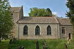 Church of St Mary |
| Ann Elizabeth Health Foods/The Reindeer Inn | Banbury | Public house | Early/mid-16th century | 9 April 1952 | SP4549740643 52°03′44″N 1°20′16″W |
1369571 |  Ann Elizabeth Health Foods/The Reindeer Inn |
| Banbury Cross | Banbury | Town cross | 1858 | 7 October 1969 | SP4532440399 52°03′36″N 1°20′25″W |
1199654 |  Banbury Cross |
| Browns/Clays Butchers/Lunn Poly | Banbury | House | 1650 | 9 April 1952 | SP4566240598 52°03′43″N 1°20′07″W |
1046969 |  Browns/Clays Butchers/Lunn Poly |
| Calthorpe House/Danvers House/Dashwood House | Banbury | House | 16th century or earlier | 9 April 1952 | SP4541740255 52°03′32″N 1°20′20″W |
1046966 | |
| Carpenters | Banbury | House | 19th century | 9 April 1952 | SP4560640598 52°03′43″N 1°20′10″W |
1200100 | 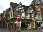 Carpenters |
| FB Hancock solicitors | Banbury | House | 17th century | 9 April 1952 | SP4536840510 |
1283202 |  FB Hancock solicitors |
| Hardwick House | Banbury | Farmhouse | 16th century | 9 April 1952 | SP4589942956 52°04′59″N 1°19′54″W |
1200559 | 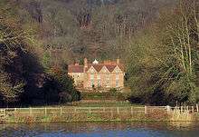 Hardwick House |
| Jervis and Partners | Banbury | House | c.1830–40 | 9 April 1952 | SP4533940105 52°03′27″N 1°20′25″W |
1046914 | |
| Johnson and Gaunt Solicitors | Banbury | House | 17th century | 7 October 1969 | SP4540840672 52°03′45″N 1°20′21″W |
1200151 | .jpg) Johnson and Gaunt Solicitors |
| Nationwide and entrance to Unicorn Hotel | Banbury | Hotel | Mid-17th century | 9 April 1952 | SP4561140624 52°03′44″N 1°20′10″W |
1369548 |  Nationwide and entrance to Unicorn Hotel |
| Oxfordshire County Council Social Services | Banbury | House | Early 18th century | 9 April 1952 | SP4528440192 52°03′30″N 1°20′27″W |
1046912 | |
| Unicorn Hotel | Banbury | Inn | Mid-17th century | 9 April 1952 | SP4558940623 52°03′44″N 1°20′11″W |
1200118 |  Unicorn Hotel |
| Church of St John | Barford St. John, Barford St. John and St. Michael | Church | 12th century | 8 December 1955 | SP4389333201 51°59′44″N 1°21′44″W |
1046238 | .jpg) Church of St John |
| Manor House | Barford St. Michael, Barford St. John and St. Michael | Farmhouse | Probably 16th/17th century | 8 December 1955 | SP4319932740 51°59′29″N 1°22′20″W |
1046247 | |
| Church of St Michael | Begbroke | Church | Late 12th century | 7 December 1966 | SP4684613942 51°49′20″N 1°19′18″W |
1291232 | 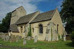 Church of St Michael |
| The Old Priory and attached garden walls | Bicester | House | 15th century | 31 January 1952 | SP5842322118 51°53′40″N 1°09′09″W |
1046470 | |
| The Old Vicarage | Bicester | House | c.1500 | 3 January 1952 | SP5825522309 51°53′47″N 1°09′17″W |
1199889 | |
| Bletchingdon Park | Bletchingdon | Country house | 1782 | 26 November 1951 | SP5053318026 51°51′31″N 1°16′04″W |
1219924 | |
| Church of St Giles | Bletchingdon | Church | Mid-13th century | 7 December 1966 | SP5065318058 51°51′32″N 1°15′57″W |
1220032 | 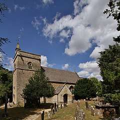 Church of St Giles |
| Home Farmhouse | Bletchingdon | Farmhouse | 17th century | 26 November 1951 | SP5030417512 51°51′14″N 1°16′16″W |
1220080 | |
| Rectory Farmhouse | Bloxham | Farmhouse | Mid-15th century | 8 December 1955 | SP4295035657 52°01′04″N 1°22′32″W |
1046194 | |
| Church of St John the Baptist | Bodicote | Church | 13th century | 8 December 1955 | SP4599337683 52°02′08″N 1°19′51″W |
1277948 |  Church of St John the Baptist |
| Church of St Lawrence | Caversfield | Church | 10th/11th century | 7 December 1966 | SP5806325202 51°55′20″N 1°09′26″W |
1046533 |  Church of St Lawrence |
| Churchyard cross approximately 5 metres south west of Church of St Mary the Virgin | Charlton-on-Otmoor | Cross | 14th/15th century | 10 April 1987 | SP5618015808 51°50′17″N 1°11′10″W |
1045779 | 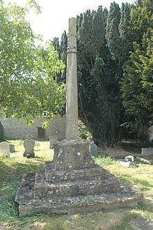 Churchyard cross approximately 5 metres south west of Church of St Mary the Virgin |
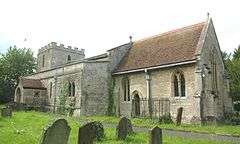
| Church of St Mary | Great Chesterton, Chesterton | Church | 12th century | 7 December 1966 | SP5618821366 51°53′17″N 1°11′06″W |
1300898 | 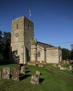 Church of St Mary |
| Manor Farm House | Great Chesterton, Chesterton | Farmhouse | 12th century and later | 9 December 1987 | SP5631621367 51°53′17″N 1°10′59″W |
1369747 | |
| Church of St James the Great | Claydon, Claydon with Clattercot | Church | 12th century | 8 December 1955 | SP4570350047 52°08′49″N 1°20′01″W |
1287785 |  Church of St James the Great |
| Priory Farmhouse | Clattercote, Claydon with Clattercot | Farmhouse | Late 13th/early 14th century | 8 December 1955 | SP4579849200 52°08′21″N 1°19′56″W |
1215881 | |
| Church of St Mary | Cottisford | Church | 13th century | 7 December 1966 | SP5872931063 51°58′30″N 1°08′47″W |
1046439 | 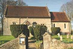 Church of St Mary |
| Castle End Monks Court | Deddington | Farmhouse | 16th century or earlier | 8 December 1955 | SP4700931700 51°58′54″N 1°19′01″W |
1046345 | |
| Castle House | Deddington | Manor house | 13th century | 8 December 1955 | SP4675231746 51°58′56″N 1°19′14″W |
1300851 | 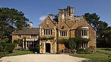 Castle House |
| Church of St Peter and St Paul | Deddington | Church | Early 13th century | 8 December 1955 | SP4675031699 51°58′54″N 1°19′15″W |
1365859 |  Church of St Peter and St Paul |
| Maunds Farmhouse | Deddington | Farmhouse | Early 17th century | 19 June 1987 | SP4655131627 51°58′52″N 1°19′25″W |
1046314 | 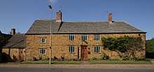 Maunds Farmhouse |
| Plough House The Steps | Deddington | House | Mid-17th century | 8 December 1955 | SP4675031306 51°58′42″N 1°19′15″W |
1046329 |  Plough House The Steps |
| The Hermitage | Deddington | House | Mid-17th century | 8 December 1955 | SP4666731717 51°58′55″N 1°19′19″W |
1046323 | 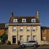 The Hermitage |
| Church of St Peter | Drayton | Church | 14th century | 8 December 1955 | SP4283741564 52°04′15″N 1°22′35″W |
1369591 | 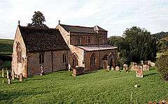 Church of St Peter |
| Drayton Arch approximately 300 metres to south of Park Farmhouse | Drayton | Folly | c.1750 | 23 February 1982 | SP4285941082 52°03′59″N 1°22′34″W |
1369593 |  Drayton Arch approximately 300 metres to south of Park Farmhouse |
| Church of St Anne | Epwell | Church | 13th century | 8 December 1955 | SP3529240473 52°03′41″N 1°29′12″W |
1369555 | 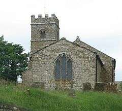 Church of St Anne |
| Church of St Olave | Fritwell | Church | 12th century | 7 December 1966 | SP5245229301 51°57′35″N 1°14′17″W |
1046892 |  Church of St Olave |
| Fritwell Manor | Fritwell | House | 1619 | 26 November 1951 | SP5240329479 51°57′41″N 1°14′20″W |
1266393 | |
| Manor House | Water Eaton, Gosford and Water Eaton | Hall house | c.1586 | 26 November 1951 | SP5156012067 51°48′18″N 1°15′13″W |
1046562 | 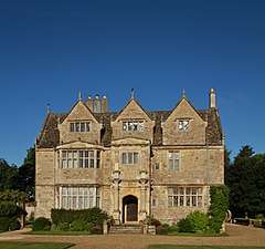 Manor House |
| St Frideswides Farmhouse | Cutteslowe, Gosford and Water Eaton | Farmhouse | 16th century | 26 November 1951 | SP5072711266 51°47′52″N 1°15′57″W |
1286525 | |
| Church of St Giles | Hampton Gay | Church | 1767–72 | 7 December 1966 | SP4845816450 51°50′40″N 1°17′53″W |
1291122 | 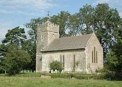 Church of St Giles |
| Church of St Mary | Hampton Poyle | Church | Late 13th century | 7 December 1966 | SP4983715522 51°50′10″N 1°16′41″W |
1220144 |  Church of St Mary |
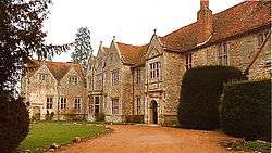
| Hanwell Castle | Hanwell | House | c.1498 | 8 December 1955 | SP4363143605 52°05′21″N 1°21′53″W |
1287674 | 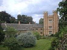 Hanwell Castle |
| Granary/dovecote at SP 5652 3068 | Tusmore, Hardwick with Tusmore | Dovecote | 16th century | 7 December 1966 | SP5647830687 51°58′18″N 1°10′45″W |
1046450 | .jpg) Granary/dovecote at SP 5652 3068 |
| Hardwick Manor House | Hardwick, Hardwick with Tusmore | Farmhouse | c.1580 to 1643 | 26 November 1951 | SP5765729602 51°57′43″N 1°09′44″W |
1046449 | .jpg) Hardwick Manor House |
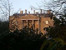
| Swerford Park | Swerford Park, Hook Norton | House | 18th century | 8 December 1955 | SP3640931310 51°58′45″N 1°28′17″W |
1369836 | |
| Manor House | Horley | Clergy house | 16th/17th century | 8 December 1955 | SP4168243857 52°05′29″N 1°23′35″W |
1216542 |  Manor House |
| Proffitt's House | Hornton | House | Mid-17th century | 8 December 1955 | SP3932645072 52°06′09″N 1°25′38″W |
1216568 |  Proffitt's House |
| Studley Almshouses | Horton-cum-Studley | Almshouse | 1639 | 26 November 1951 | SP5977712367 51°48′24″N 1°08′04″W |
1193018 |  Studley Almshouses |
| Studley Priory | Studley, Horton-cum-Studley | Priory/Hotel | 15th/early 16th century | 26 November 1951 | SP5975312219 51°48′20″N 1°08′05″W |
1193052 | |
| The Old Weir | Studley, Horton-cum-Studley | House | c.1350 | 10 April 1987 | SP6022612555 51°48′30″N 1°07′40″W |
1046568 | |
| The Old Rectory | Islip | House | 19th/20th century | 26 November 1951 | SP5273113996 51°49′20″N 1°14′11″W |
1046539 |  The Old Rectory |
| Dovecote approximately 10 metres north north east of the Old Rectory and Dovecote End | Kidlington | Dovecote | 16th century | 26 November 1951 | SP4972214455 51°49′35″N 1°16′48″W |
1290949 | |
| The Vicarage | Kidlington | Vicarage | Mid-16th century | 26 November 1951 | SP4969114341 51°49′32″N 1°16′49″W |
1290954 | |
| Church of St Mary | Kirtlington | Church | Early 12th century, possibly earlier | 7 December 1966 | SP5002119493 51°52′18″N 1°16′30″W |
1300872 | 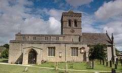 Church of St Mary |
| Barn approximately 50 metres south of Manor Farmhouse | Launton | Barn | 14th/15th century | 9 December 1987 | SP6036622816 51°54′02″N 1°07′27″W |
1232879 | |
| Church of St Mary | Lower Heyford | Church | 13th century | 7 December 1966 | SP4851124872 51°55′13″N 1°17′46″W |
1225457 | 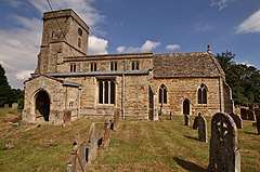 Church of St Mary |
| Heyford Bridge: that part in the parish of Lower Heyford | Lower Heyford | Bridge | 1255 | 26 November 1951 | SP4785924764 51°55′10″N 1°18′20″W |
1266350 | 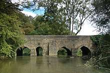 Heyford Bridge: that part in the parish of Lower Heyford |
| Church of All Saints | Middleton Stoney | Church | Mid-12th century | 7 December 1966 | SP5310823252 51°54′19″N 1°13′46″W |
1276839 | 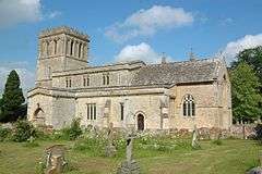 Church of All Saints |
| Middleton Park: garage wing and northern pair of forecourt lodges | Middleton Stoney | House | 1938 | 26 November 1951 | SP5254923281 51°54′20″N 1°14′15″W |
1232950 | |
| Middleton Park: service wing and southern pair of forecourt lodges | Middleton Stoney | House | 1938 | 26 November 1951 | SP5252723242 51°54′19″N 1°14′16″W |
1232953 | |
| Church of All Saints | Mixbury | Church | 12th century | 7 December 1966 | SP6092833994 52°00′04″N 1°06′50″W |
1192977 | 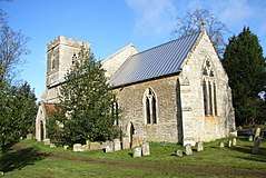 Church of All Saints |
| Church of All Saints | Mollington | Church | Late 13th century or early 14th century | 8 December 1955 | SP4422647499 52°07′27″N 1°21′20″W |
1228026 | 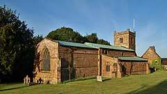 Church of All Saints |
| Church of St Giles | Noke | Church | 13th century | 7 December 1966 | SP5444613173 51°48′52″N 1°12′42″W |
1369713 | 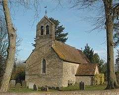 Church of St Giles |
| Church of St Mary | North Aston | Church | 14th century | 8 December 1955 | SP4805028894 51°57′23″N 1°18′08″W |
1200620 | 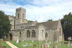 Church of St Mary |
| Church of St Andrew | Oddington | Church | 13th century | 7 December 1966 | SP5526014801 51°49′45″N 1°11′58″W |
1369717 | 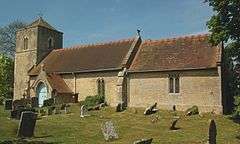 Church of St Andrew |
| Church of St Nicholas | Piddington | Church | Late 13th century | 7 December 1966 | SP6399916980 51°50′52″N 1°04′20″W |
 Church of St Nicholas | |
| Church of Holy Trinity | Shenington | Church | 12th century | 8 December 1955 | SP3727942786 52°04′56″N 1°27′27″W |
1183960 | 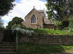 Church of Holy Trinity |
| The Beeches | Alkerton, Shenington with Alkerton | House | 1716 | 28 January 1981 | SP3768142836 52°04′57″N 1°27′06″W |
1046834 | |
| The Old Rectory and attached wall | Alkerton, Shenington with Alkerton | House | 1625 | 20 September 1988 | SP3774542892 52°04′59″N 1°27′02″W |
1046833 | |
| Village Cross | Thrupp, Shipton-on-Cherwell and Thrupp | Village cross | c.1500 | 7 December 1966 | SP4804715773 51°50′19″N 1°18′15″W |
1210769 | |
| Church of St Martin | Shutford | Church | Late 12th/13th century | 8 December 1955 | SP3860940183 52°03′31″N 1°26′18″W |
1184161 |  Church of St Martin |
| Manor House and abutting kitchen block | Shutford | Manor house | 17th century | 8 December 1955 | SP3864640167 52°03′31″N 1°26′16″W |
1300239 |  Manor House and abutting kitchen block |
| Barn at Manor Farm at SP52183155 | Souldern | Threshing barn | c.1400 | 3 October 1988 | SP5206031622 51°58′50″N 1°14′36″W |
1046430 | |
| Church of St Mary | Souldern | Church | Mid-12th century | 7 December 1966 | SP5230131691 51°58′52″N 1°14′24″W |
1046428 | 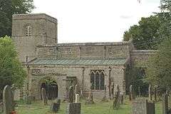 Church of St Mary |
| College Farmhouse | South Newington | Farmhouse | 1659 | 8 December 1955 | SP4077333307 51°59′48″N 1°24′27″W |
1249042 |  College Farmhouse |
| Church of St Peter and St Paul | Steeple Aston | Church | 13th century | 8 December 1955 | SP4760026070 51°55′52″N 1°18′33″W |
1357162 |  Church of St Peter and St Paul |
| Cuttle Mill | Steeple Aston | House | Late 17th/early 18th century | 8 December 1955 | SP4801125114 51°55′21″N 1°18′12″W |
1066593 | |
| Eyecatcher at SP48282603 | Steeple Aston | Folly | c.1740 | 8 December 1955 | SP4828026030 51°55′51″N 1°17′57″W |
1357142 | 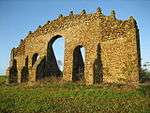 Eyecatcher at SP48282603 |
| Church of St Peter | Stoke Lyne | Church | 12th century | 7 December 1966 | 49°46′01″N 7°33′26″W | 1193248 | _St_Peter's_Church_-_geograph.org.uk_-_69746.jpg) Church of St Peter |
| Barn at Manor House | Tadmarton | Grange barn | 15th century | 8 December 1955 | SP3926337902 52°02′17″N 1°25′44″W |
1283551 | |
| Church of St Mary | Upper Heyford | Church | 14th century | 7 December 1966 | SP4948325866 51°55′45″N 1°16′54″W |
1226006 | 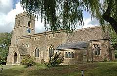 Church of St Mary |
| Wardington Manor | Upper Wardington, Wardington | Manor house | 15th or 16th century | 8 December 1955 | SP4934146062 52°06′38″N 1°16′51″W |
1228757 | |
| Williamscot House, late sixteenth-century range | Williamscot, Wardington | Country house | c.1568 | 8 December 1955 | SP4779345698 52°06′27″N 1°18′13″W |
1287374 | |
| Church of St Mary | Weston-on-the-Green | Church | Pre-Conquest, early C13 | 7 December 1966 | SP5311018580 51°51′48″N 1°13′49″W |
1233027 | 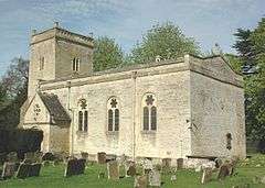 Church of St Mary |
| Weston Manor Hotel | Weston-on-the-Green | Hall house | Late medieval, rebuilt 1820 | 7 December 1966 | SP5337418450 51°51′44″N 1°13′35″W |
1276762 | 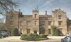 Weston Manor Hotel |
| Church of All Saints | Wroxton | Church | 14th century | 8 December 1955 | SP4173041760 52°04′22″N 1°23′33″W |
1300046 | 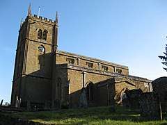 Church of All Saints |
| Church of St Mary Magdalene | Balscote, Wroxton | Church | 14th century | 8 December 1955 | SP3899741733 52°04′21″N 1°25′57″W |
1299831 | .jpg) Church of St Mary Magdalene |
| Dovecote approximately 200 metres south west of Wroxton College | Wroxton | Dovecote | 1745 | 20 September 1988 | SP4148341515 52°04′14″N 1°23′46″W |
1046772 |  Dovecote approximately 200 metres south west of Wroxton College |
| Gateway, gates, wall and attached lodge to Wroxton College | Wroxton | Gate | 1771 | 20 September 1988 | SP4143441738 52°04′21″N 1°23′49″W |
1369625 | |
| Icehouse approximately 150 metres north east of Wroxton College | Wroxton | Icehouse | Early 18th century | 20 September 1988 | SP4184141695 52°04′19″N 1°23′27″W |
1369626 | |
| Obelisk approximately 400 metres south east of Wroxton College | Wroxton | Obelisk | c.1750 | 23 February 1988 | SP4196141272 52°04′06″N 1°23′21″W |
1046770 |  Obelisk approximately 400 metres south east of Wroxton College |
| Priory Farmhouse | Balscote, Wroxton | Farmhouse | 14th century | 8 December 1955 | SP3923541665 52°04′19″N 1°25′44″W |
1299886 | |
| Base and shaft of churchyard cross approximately 16 metres south south east of south porch of Church of St Bartholomew | Yarnton | Cross | 14th century | 26 February 1988 | SP4777011664 51°48′06″N 1°18′31″W |
1290168 |  Base and shaft of churchyard cross approximately 16 metres south south east of south porch of Church of St Bartholomew |
| Yarnton Manor and attached wall and gateway | Yarnton | Farmhouse | Post Civil War–1895 | 26 November 1951 | SP4769311627 51°48′05″N 1°18′35″W |
1290170 | 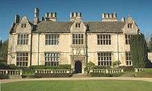 Yarnton Manor and attached wall and gateway |
.jpg)
gollark: Not directly, but it is important to understand that people often care about that sort of thing *anyway*.
gollark: My site is ad-free even though I could undoubtedly make an entire $0.10 off it if I monetized it.
gollark: > I dont and will never understand why people give enough of a shit about people being trans to actually go and complain online ectThe general thing is that some people/groups see some things people do as actively against their moral system in some way. You should probably be able to understand that.
gollark: If people kept mixing them up, it would *basically* destroy civilization. Nobody would be able to tell exactly how much storage their drive had and drive manufacturers would ship them with slightly less capacity than they should have. It would be *anarchy*.
gollark: It should be TiB then, and it would be 256GiB. Correct unit prefixes are important!
See also
Notes
- The date given is the date used by Historic England as significant for the initial building or that of an important part in the structure's description.
- Sometimes known as OSGB36, the grid reference is based on the British national grid reference system used by the Ordnance Survey.
- The "List Entry Number" is a unique number assigned to each listed building and scheduled monument by Historic England.
External links
![]()
This article is issued from Wikipedia. The text is licensed under Creative Commons - Attribution - Sharealike. Additional terms may apply for the media files.