Grade II* listed buildings in Copeland
There are over 20,000 Grade II* listed buildings in England. This page is a list of these buildings in the district of Copeland in Cumbria.
List of buildings
| Name | Location | Type | Completed [note 1] | Date designated | Grid ref.[note 2] Geo-coordinates |
Entry number [note 3] | Image |
|---|---|---|---|---|---|---|---|
| Cross Lacon in garden to south of Dower House | Arlecdon and Frizington | Cross | Possibly 13th century | 9 August 1984 | NY0246616680 54°32′09″N 3°30′32″W |
1086720 |  |
| Seaton Hall with attached ruins | Bootle | House | 16th century | 8 September 1967 | SD1074789923 54°17′50″N 3°22′22″W |
1086649 | |
| United Reformed Church and 2 attached houses to east | Bootle | House | 1780 | 14 July 1989 | SD1077688176 54°16′53″N 3°22′19″W |
1252005 | |
| Eskdale Corn Mill | Boot, Eskdale | Corn mill | 1578 | 21 January 1985 | NY1764201146 54°23′57″N 3°16′12″W |
1086655 | 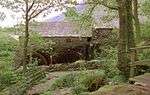 Eskdale Corn Mill |
| Gatepiers to South of Gosforth Hall | Gosforth | Gate pier | c.1658 | 9 March 1967 | NY0716503621 54°25′10″N 3°25′56″W |
1063743 | 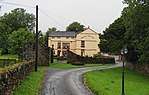 Gatepiers to South of Gosforth Hall |
| Gosforth Hall | Gosforth | House | c.1658 | 9 March 1967 | NY0715803652 54°25′11″N 3°25′56″W |
1086661 | |
| Library and that part of Village Hall which originally constituted Denton Hill | Gosforth | House | 1628 | 9 March 1967 | NY0688403523 54°25′07″N 3°26′11″W |
1336018 | |
| Gatehouse range to south of Haile Hall | Haile | House | 16th century or 17th century | 9 March 1967 | NY0355009096 54°28′05″N 3°29′23″W |
1086615 | |
| Haile Hall | Haile | House | 1591 | 9 March 1967 | NY0357009146 54°28′07″N 3°29′22″W |
1084317 | 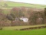 Haile Hall |
| Church of St Paul | Irton with Santon | Parish church | 1857 | 8 September 1967 | NY0916200470 54°23′30″N 3°24′02″W |
1086671 | 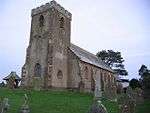 Church of St Paul |
| Medieval tower incorporated into Irton Hall | Irton with Santon | Fortified house | 14th century | 21 January 1985 | NY1048600579 54°23′34″N 3°22′48″W |
1067822 | 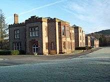 Medieval tower incorporated into Irton Hall |
| Church of St Michael | Lamplugh | Parish church | 1870 | 9 March 1967 | NY0885720797 54°34′27″N 3°24′41″W |
1086674 | 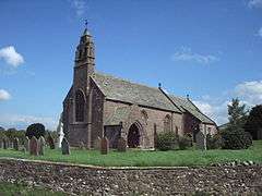 Church of St Michael |
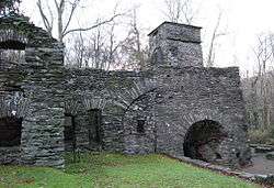
| Duddon Iron Furnace | Millom Without | Metal production furnace | c.1737 | 8 September 1967 | SD1966288303 54°17′02″N 3°14′08″W |
1068577 | |
| Rosehill, house and adjoining wall | Moresby | House | Late 18th century | 9 March 1967 | NX9909820298 54°34′04″N 3°33′44″W |
1086712 | |
| Farm building immediately west of Cropple How Farmhouse | Muncaster | Farmhouse | Mid- to late 15th century | 27 February 2009 | SD1285497743 54°22′04″N 3°20′34″W |
1393157 | |
| Pelham House | Ponsonby | House | c.1780 | 14 July 1989 | NY0378105753 54°26′17″N 3°29′06″W |
1356190 | |
| Manor Stead and house adjoining to north | St Bees | House | Pre-1517 | 9 March 1967 | NX9714311875 54°29′30″N 3°35′22″W |
1086684 | 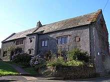 Manor Stead and house adjoining to north |
| Pow Bridge over Pow Beck | St Bees | Road bridge | 1585 | 9 August 1984 | NX9701312028 54°29′35″N 3°35′29″W |
1137347 | 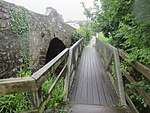 Pow Bridge over Pow Beck |
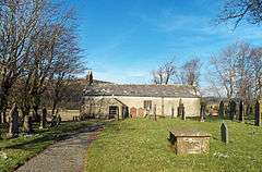
| Church of St Bridget | St Bridget Beckermet | Church | Medieval | 9 March 1967 | NY0149406066 54°26′26″N 3°31′13″W |
1086588 | 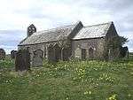 Church of St Bridget |
| Gatehouse to Calder Abbey | Calder Abbey, St. Bridget Beckermet | Abbey | Probably 14th century | 14 July 1989 | NY0496006396 54°26′39″N 3°28′01″W |
1086629 | |
| The Monks Oven | Calder Abbey, St. Bridget Beckermet | Abbey | Uncertain | 14 July 1989 | NY0520506468 54°26′41″N 3°27′48″W |
1068656 | 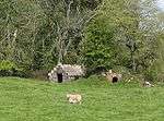 The Monks Oven |
| Church of St John | Ulpha | Parish church | 17th century | 8 September 1967 | SD1980493246 54°19′42″N 3°14′05″W |
1068873 |  Church of St John |
| Church of St John | Waberthwaite | Parish church | 13th century | 8 September 1967 | SD1002695116 54°20′37″N 3°23′08″W |
1086644 | |
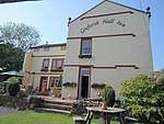
| Church of St Michael and All Angels | Nether Wasdale, Wasdale | Parish church | 15th century | 21 January 1985 | NY1248404074 54°25′28″N 3°21′01″W |
1343668 | .jpg) Church of St Michael and All Angels |
| Nether End Farmhouse | Weddicar | Farmhouse | 1624 | 9 March 1967 | NX9954416071 54°31′48″N 3°33′14″W |
1137431 | |
| Barracks Mill | Whitehaven | Fireproof factory | 1809 | 13 September 1972 | NX9736417813 54°32′42″N 3°35′17″W |
1038943 | .jpg) Barracks Mill |
| No 151 Queen Street (including Area Railings) | Whitehaven | House | Georgian | 20 July 1949 | NX9729417972 54°32′48″N 3°35′21″W |
1086737 | 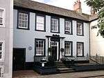 No 151 Queen Street (including Area Railings) |
| Somerset House | Whitehaven | House | 18th century | 20 July 1949 | NX9768418125 54°32′53″N 3°35′00″W |
1086776 | 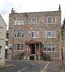 Somerset House |
| 44, 45 Roper Street | Whitehaven | House | Georgian Gothic | 13 September 1972 | NX9731618002 54°32′49″N 3°35′20″W |
1336017 | 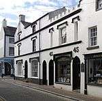 44, 45 Roper Street |
| 14 Scotch Street | Whitehaven | House | Mid-18th century | 20 July 1949 | NX9747117949 54°32′47″N 3°35′11″W |
1335979 | 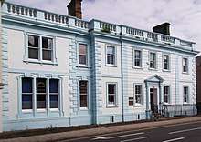 14 Scotch Street |
Notes
- The date given is the date used by Historic England as significant for the initial building or that of an important part in the structure's description.
- Sometimes known as OSGB36, the grid reference is based on the British national grid reference system used by the Ordnance Survey.
- The "List Entry Number" is a unique number assigned to each listed building and scheduled monument by Historic England.
External links
![]()
This article is issued from Wikipedia. The text is licensed under Creative Commons - Attribution - Sharealike. Additional terms may apply for the media files.