Grade II* listed buildings in Ashford (borough)
There are over 20,000 Grade II* listed buildings in England. This page is a list of these buildings in the district of Ashford in Kent.
List of buildings
| Name | Location | Type | Completed [note 1] | Date designated | Grid ref.[note 2] Geo-coordinates |
Entry number [note 3] | Image |
|---|---|---|---|---|---|---|---|
| Cobb's Hall | Aldington | Continuous jetty house | c.1525–30 | 13 October 1952 | TR0666936276 51°05′19″N 0°56′59″E |
1184555 | 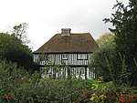 Cobb's Hall |
| Court Lodge Farmhouse | Aldington | Farmhouse | 17th century | 27 November 1957 | TR0752036203 51°05′15″N 0°57′42″E |
1071209 | 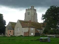 Court Lodge Farmhouse |
| Ruffyn's Hill Farmhouse and walls projecting | Aldington | House | 16th century or earlier | 13 October 1952 | TR0717036011 51°05′10″N 0°57′24″E |
1184521 |  |
| Horne's Place | Appledore | Box frame house | 17th century | 4 June 1952 | TQ9574530870 51°02′38″N 0°47′28″E |
1362879 | 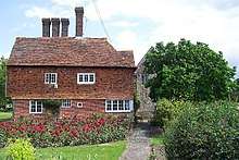 Horne's Place |
| Bridge House | Ashford | House | 18th century | 24 September 1951 | TR0144042774 51°08′56″N 0°52′44″E |
1071079 | 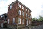 Bridge House |
| Nightingale House | Ashford | House | 18th century | 24 September 1951 | TR0127342767 51°08′56″N 0°52′35″E |
1071078 | 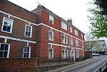 Nightingale House |
| The College | Ashford | Vicarage | Edward IV | 24 September 1951 | TR0106142703 51°08′54″N 0°52′24″E |
1184332 |  The College |
| The Doctor Wilks Memorial Hall | Ashford | Grammar school | 1635 | 24 September 1951 | TR0098042760 51°08′56″N 0°52′20″E |
1071118 | 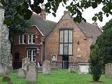 The Doctor Wilks Memorial Hall |
| Whist House | Ashford | House | 1707 | 24 September 1951 | TR0134542465 51°08′46″N 0°52′38″E |
1299918 | |
| 22 North Street | Ashford | House | 18th century | 24 September 1951 | TR0106842917 51°09′01″N 0°52′25″E |
1071037 | 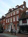 22 North Street |
| 91 High Street | Ashford | House | 18th century | 24 September 1951 | TR0091042816 51°08′58″N 0°52′16″E |
1184508 | |
| 51–55 High Street | Ashford | House | 18th century | 24 September 1951 | TR0105142770 51°08′56″N 0°52′24″E |
1362831 | |
| Pimphurst Farmhouse | Bethersden | Farmhouse | Circa early 16th century | 10 October 1980 | TQ9252942129 51°08′46″N 0°45′04″E |
1070788 | |
| Ring Cottage | Wissenden, Bethersden | Timber-framed house | 15th century | 14 February 1967 | TQ9127541132 51°08′15″N 0°43′58″E |
1362987 | |
| The Old House | Wissenden, Bethersden | Timber-framed house | 15th century | 14 February 1967 | TQ9068141448 51°08′26″N 0°43′28″E |
1070764 | 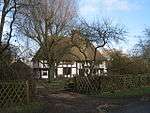 The Old House |
| Tuesnoad Cottage | Tuesnoad, Bethersden | Farmhouse | 16th century or earlier | 14 February 1967 | TQ9086242136 51°08′48″N 0°43′39″E |
1362986 | |
| Biddenden Place | Biddenden | House | Dated 1624 | 4 June 1952 | TQ8515838301 51°06′51″N 0°38′38″E |
1299500 | 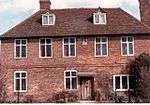 Biddenden Place |
| Birchley Farmhouse | Biddenden | Farmhouse | 16th century | 16 August 1962 | TQ8452537196 51°06′16″N 0°38′04″E |
1071005 | 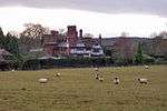 Birchley Farmhouse |
| Castwisell Manor Farmhouse | Biddenden | Farmhouse | 15th century | 4 June 1952 | TQ8348337466 51°06′26″N 0°37′11″E |
1184788 | |
| Great Bachelors Hall | Biddenden | Timber-framed house | 15th century | 4 June 1952 | TQ8326638496 51°06′59″N 0°37′01″E |
1070991 | |
| Hendon Hall | Biddenden | House | Late 17th century | 4 June 1952 | TQ8509238330 51°06′52″N 0°38′35″E |
1070956 | 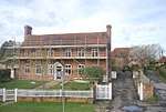 Hendon Hall |
| Standen | Standen, Biddenden | Guesthouse | 15th century | 16 August 1962 | TQ8559140056 51°07′47″N 0°39′04″E |
1185339 | |
| The Cott | Biddenden | House | c.1535 | 9 August 1979 | TQ8556139355 51°07′24″N 0°39′01″E |
1071009 | |
| Vane Court | Biddenden | Wealden house | 15th century | 9 August 1979 | TQ8588740472 51°08′00″N 0°39′20″E |
1362899 | 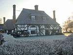 Vane Court |
| Barn about 50 metres south-west of Court Lodge | Bilsington | Aisled barn | 15th century | 10 August 1988 | TR0411534234 51°04′16″N 0°54′44″E |
1300006 | |
| Church of St Peter and St Paul | Bilsington | Church | 12th century | 27 November 1957 | TR0421634264 51°04′17″N 0°54′49″E |
1071191 | 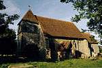 Church of St Peter and St Paul |
| Boughton Court | Boughton Aluph | Manor house | 16th century | 13 October 1952 | TR0328048209 51°11′49″N 0°54′29″E |
1362711 | |
| The Hall | Brabourne | House | Early 18th century | 13 October 1952 | TR0884042546 51°08′39″N 0°59′03″E |
1232797 | |
| Barn about 20 metres west | Brook | Barn | Mid-17th century | 27 November 1957 | TR0650342339 51°08′35″N 0°57′03″E |
1232968 |  Barn about 20 metres west |
| Court Lodge | Brook | House | 15th century or earlier | 27 November 1957 | TR0663344231 51°09′36″N 0°57′14″E |
1276825 | |
| Forstal Farmhouse | Brook | Farmhouse | 17th century | 27 November 1957 | TR0623644003 51°09′29″N 0°56′53″E |
1232970 | |
| Troy Town House and Wall | Troy Town, Brook | House | Late 17th century | 15 March 1988 | TR0711244354 51°09′39″N 0°57′38″E |
1232977 | |
| Church of St Cosmas and St Damian | Challock | Church | 1504 | 27 November 1957 | TR0114449196 51°12′24″N 0°52′41″E |
1185088 | 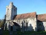 Church of St Cosmas and St Damian |
| Great Paddock Farmhouse | Challock | Manor house | Early 17th century | 27 November 1957 | TQ9916150244 51°13′00″N 0°51′01″E |
1071302 | 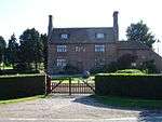 Great Paddock Farmhouse |
| Laurenden Forstal, Nine Chimneys | Challock Lees, Challock | Jettied house | 17th century | 13 August 1984 | TR0101250478 51°13′05″N 0°52′37″E |
1362736 | |
| Brockton Manor | Charing Heath, Charing | House | 18th century | 14 February 1967 | TQ9242449006 51°12′28″N 0°45′12″E |
1070774 | |
| Chapel at Newlands Stud Farm | Charing | Chapel | Late Norman | 17 September 1952 | TQ9362748211 51°12′01″N 0°46′12″E |
1071538 | 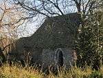 Chapel at Newlands Stud Farm |
| Ludwell House | Charing | House | Early 18th century | 17 September 1952 | TQ9529449471 51°12′40″N 0°47′41″E |
1185767 | 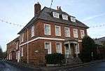 Ludwell House |
| Newlands Stud Farmhouse | Charing | Farmhouse | Possibly late Norman | 10 October 1980 | TQ9368748185 51°12′00″N 0°46′16″E |
1071537 | |
| Peirce House | Charing | House | 13th century | 17 September 1952 | TQ9527249423 51°12′38″N 0°47′40″E |
1070742 |  Peirce House |
| Sherborne House | Charing | House | Mid-16th century | 17 September 1952 | TQ9527049387 51°12′37″N 0°47′39″E |
1070740 | 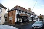 Sherborne House |
| The Old House | Charing | House | 14th century | 17 September 1952 | TQ9519449236 51°12′32″N 0°47′35″E |
1186103 | 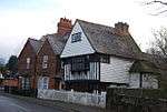 The Old House |
| The Old Vicarage, Vicarage Cottage | Charing | Vicarage | c.1702 | 14 February 1967 | TQ9550149385 51°12′37″N 0°47′51″E |
1185849 | 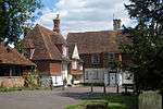 The Old Vicarage, Vicarage Cottage |
| Tithe Barn to the south-east of Pett Place | Charing | Tithe barn | Medieval, refaced 17th century | 14 February 1967 | TQ9614348921 51°12′21″N 0°48′23″E |
1362628 | |
| Tram Hatch | Charing | House | 15th to 16th century | 10 October 1980 | TQ9234747474 51°11′39″N 0°45′05″E |
1070770 | |
| Wakeley House | Charing | House | 18th century | 17 September 1952 | TQ9533649517 51°12′41″N 0°47′43″E |
1070747 | 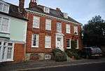 Wakeley House |
| Wickens Manor | Charing | House | 16th century | 17 September 1952 | TQ9602348331 51°12′02″N 0°48′16″E |
1071548 | |
| The Vicarage | Chilham | Vicarage | 1746 | 13 October 1952 | TR0694253682 51°14′41″N 0°57′49″E |
1071252 | 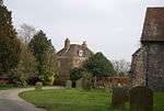 The Vicarage |
| Hunt Street Farmhouse | Crundale | Farmhouse | c.1595 | 13 October 1952 | TR0906848592 51°11′54″N 0°59′28″E |
1185666 | |
| Lake House | Eastwell | House | Late 13th century | 13 October 1952 | TR0101347326 51°11′23″N 0°52′31″E |
1362760 | 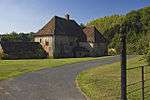 Lake House |
| Link House | Egerton | Timber-framed house | 15th century | 17 September 1952 | TQ8976847207 51°11′33″N 0°42′52″E |
1071518 | 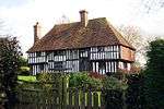 Link House |
| Court Lodge | Great Chart with Singleton | House | 13th century | 17 September 1952 | TQ9791441934 51°08′33″N 0°49′41″E |
1362641 | 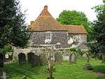 Court Lodge |
| Little Singleton | Great Chart with Singleton | Timber-framed house | 16th century or earlier | 14 February 1967 | TQ9706141678 51°08′26″N 0°48′56″E |
1071474 | |
| Singleton Manor | Great Chart with Singleton | Manor house | 16th century or earlier | 17 September 1952 | TQ9888241647 51°08′22″N 0°50′30″E |
1116272 | |
| Timber-framed building in the south-west corner of the churchyard of Church of St Mary [Pest House] | Great Chart with Singleton | Timber-framed house | 16th century or earlier | 14 February 1967 | TQ9796041884 51°08′31″N 0°49′43″E)] |
1071488 | 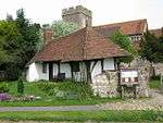 Timber-framed building in the south-west corner of the churchyard of Church of St Mary [Pest House] |
| Yardhurst | Daniel's Water, Great Chart with Singleton | Timber-framed house | 15th century | 17 September 1952 | TQ9557641172 51°08′11″N 0°47′39″E |
1071478 | |
| South Hill and wall and steps attached | Hastingleigh | House | c.1640 | 27 November 1957 | TR0960743995 51°09′24″N 0°59′46″E |
1276735 | |
| Potkiln Farmhouse | Further Quarter, High Halden | Farmhouse | c.1600 | 16 August 1962 | TQ8982439325 51°07′18″N 0°42′40″E |
1362889 | |
| Swinford Manor School | Swinford, Hothfield | House | 19th century | 10 October 1980 | TQ9751543725 51°09′31″N 0°49′24″E |
1115575 | |
| Church of St Mary | Kenardington | Church | 13th century | 16 August 1962 | TQ9747832132 51°03′16″N 0°48′59″E |
1116484 | 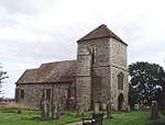 Church of St Mary |
| Manor Farmhouse | Kenardington | Farmhouse | 16th century or earlier | 4 June 1952 | TQ9691732344 51°03′24″N 0°48′31″E |
1116469 | |
| Calehill House | Calehill Park, Little Chart | House | Early 17th century | 14 February 1967 | TQ9416447142 51°11′26″N 0°46′38″E |
1071434 | |
| Barn about 30 metres north-west of Mersham Manor | Mersham | Aisled barn | Early to mid-14th century | 16 February 1989 | TR0515839414 51°07′02″N 0°55′48″E |
1233497 | 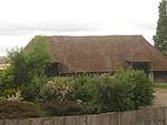 Barn about 30 metres north-west of Mersham Manor |
| Bower Farmhouse | Mersham | Farmhouse | 16th–18th century | 27 November 1957 | TR0565439388 51°07′01″N 0°56′13″E |
1276692 | |
| Mill House, Swanton Mill | South Stour, Mersham | Mill house | 16th century | 27 November 1957 | TR0388438856 51°06′46″N 0°54′41″E |
1276466 | |
| Newhouse | Mersham | House | 17th century | 13 October 1952 | TR0545039970 51°07′20″N 0°56′04″E |
1276324 | |
| Stonegreen Hall | Mersham | House | 1704 | 13 October 1952 | TR0469938350 51°06′28″N 0°55′22″E |
1233498 | |
| Stonelees | Mersham | Continuous jetty house | 16th century | 27 November 1957 | TR0450837281 51°05′54″N 0°55′10″E |
1233761 | 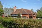 Stonelees |
| Great Bower Farmhouse | Molash | Farmhouse | 16th century | 27 November 1957 | TR0340852939 51°14′22″N 0°54′45″E |
1071242 | 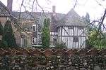 Great Bower Farmhouse |
| Parish Church of St Peter | Newenden | Church | 14th or 15th century | 16 August 1962 | TQ8343327306 51°00′57″N 0°36′50″E |
1116453 | 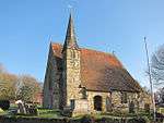 Parish Church of St Peter |
| Church of St Mary the Virgin | Orlestone | Church | Late 12th/early 13th century | 27 November 1957 | TR0001034696 51°04′36″N 0°51′14″E |
1184978 | 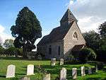 Church of St Mary the Virgin |
| Court Lodge | Orlestone | House | 16th century | 13 October 1952 | TQ9998434641 51°04′34″N 0°51′13″E |
1184992 | 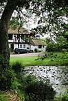 Court Lodge |
| Cooper Farmhouse | Pluckley | Farmhouse | 15th century | 14 February 1967 | TQ9151743948 51°09′46″N 0°44′16″E |
1145835 | 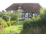 Cooper Farmhouse |
| Dowle Street Cottages | Pluckley | Farmhouse | 15th century | 14 February 1967 | TQ9357243757 51°09′37″N 0°46′01″E |
1318895 | |
| Gore Court | Pluckley | Wealden house | 15th century | 14 February 1967 | TQ9336644028 51°09′46″N 0°45′51″E |
1087078 | 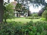 Gore Court |
| Granary and oasthouse to the south-west of Sheerland Farmhouse | Pluckley | Oasthouse | 1838 | 14 February 1967 | TQ9335045456 51°10′32″N 0°45′53″E |
1335838 | 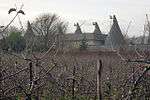 Granary and oasthouse to the south-west of Sheerland Farmhouse |
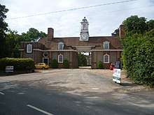
| Gatehouse to Great Maytham | Rolvenden | Gatehouse | Designed 1909–12 | 4 June 1952 | TQ8489530730 51°02′46″N 0°38′11″E |
1070886 | |
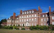
| Great Maytham | Rolvenden | House | 1721 | 4 June 1952 | TQ8481930620 51°02′43″N 0°38′07″E |
1115477 | |
| Kingpost | Rolvenden | House | 18th century | 4 June 1952 | TQ8443531581 51°03′14″N 0°37′49″E |
1115555 | 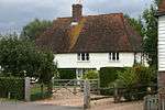 Kingpost |
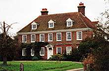
| Rawlinson Farmhouse | Hole Park, Rolvenden | Farmhouse | 15th century | 4 June 1952 | TQ8390932650 51°03′49″N 0°37′24″E |
1362909 | |
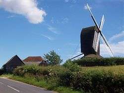
| Rolvenden Windmill | Rolvenden | Windmill | Site of mill of 1596 | 16 August 1962 | TQ8381531537 51°03′14″N 0°37′17″E |
1116206 | |
| 2, 4 and 6 Hastings Road | Rolvenden | House | 18th century | 16 August 1962 | TQ8447231258 51°03′04″N 0°37′50″E |
1070913 | 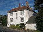 2, 4 and 6 Hastings Road |
| Church of St Peter and St Paul | Shadoxhurst | Church | 13th century | 14 February 1967 | TQ9723737601 51°06′14″N 0°48′57″E |
1326649 | 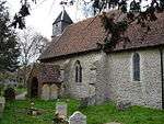 Church of St Peter and St Paul |
| Biddenden Green Farmhouse | Smarden | Farmhouse | 15th century | 14 February 1967 | TQ8878142867 51°09′14″N 0°41′53″E |
1362699 | 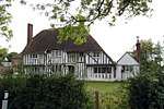 Biddenden Green Farmhouse |
| Chessenden | Smarden | Timber-framed house | 15th century | 17 September 1952 | TQ8827042405 51°09′00″N 0°41′26″E |
1359673 | 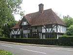 Chessenden |
| Dragon Cottage | Smarden | Timber-framed house | 15th century | 17 September 1952 | TQ8809642333 51°08′58″N 0°41′17″E |
1071360 | 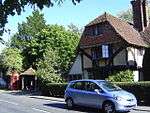 Dragon Cottage |
| Hamden Grange | Smarden | House | 14th century | 17 September 1952 | TQ8914340715 51°08′04″N 0°42′08″E |
1071368 | |
| Hartnup House | Smarden | House | 1671 | 17 September 1952 | TQ8792342335 51°08′58″N 0°41′08″E |
1366291 | 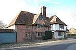 Hartnup House |
| The Cloth Hall | Smarden | Farmhouse | 16th century | 17 September 1952 | TQ8788742357 51°08′59″N 0°41′06″E |
1071366 | 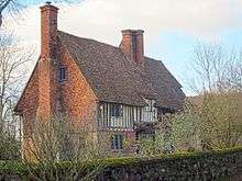 The Cloth Hall |
| Bridge House/The Thatched House | Smarden | Hall house | 15th century | 14 February 1967 | TQ8782242092 51°08′50″N 0°41′02″E |
1106331 | 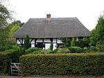 Bridge House/The Thatched House |
| West Hoy Farmhouse | Smarden | Farmhouse | 15th century | 14 February 1967 | TQ8608542329 51°09′00″N 0°39′33″E |
1071352 | 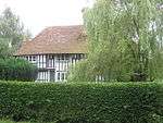 West Hoy Farmhouse |
| Evegate Manor | Smeeth | House | Early 17th century | 27 November 1957 | TR0682238975 51°06′46″N 0°57′12″E |
1362798 | |
| Lodge House | Smeeth | House | Early 18th century | 10 August 1988 | TR0852039673 51°07′06″N 0°58′41″E |
1185326 | 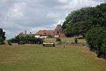 Lodge House |
| Parish Church of St Mary the Virgin | Stone-cum-Ebony | Church | 15th century; contains Roman altar | 16 August 1962 | TQ9401927347 51°00′46″N 0°45′52″E |
1362959 | 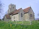 Parish Church of St Mary the Virgin |
| Ashenden | Tenterden | House | 17th century | 8 May 1950 | TQ8945331428 51°03′03″N 0°42′06″E |
1362789 | 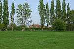 Ashenden |
| Chestnut House | Tenterden | House | 18th century | 8 May 1950 | TQ8797832965 51°03′55″N 0°40′53″E |
1203483 | |
| Church of St John the Baptist | Smallhythe, Tenterden | Church | Rebuilt 1516–17 | 8 May 1950 | TQ8935530162 51°02′23″N 0°41′59″E |
1362790 | 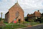 Church of St John the Baptist |
| East Hill House | Tenterden | House | 18th century | 8 May 1950 | TQ8884433657 51°04′16″N 0°41′39″E |
1031824 | |
| Finchden Manor | Tenterden | House | 1658 (dated feature) | 8 May 1950 | TQ9007933127 51°03′58″N 0°42′41″E |
1363181 | |
| Garden turrets in grounds of Hales Place | Tenterden | Tower | Early 16th century | 8 May 1950 | TQ8886133489 51°04′11″N 0°41′39″E |
1362822 | |
| Hales Place | Tenterden | House | Early 16th century | 8 May 1950 | TQ8884733400 51°04′08″N 0°41′39″E |
1071143 | |
| Maynard's Farmhouse | Tenterden | Farmhouse | Late 14th century | 8 June 1972 | TQ9015833068 51°03′56″N 0°42′45″E |
1070383 | 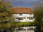 Maynard's Farmhouse |
| Old Knockwood | Tenterden | Jettied house | 16th century | 8 May 1950 | TQ8972634276 51°04′35″N 0°42′25″E |
1071130 | |
| Pigeon Hoo | Tenterden | Farmhouse | Early 15th century | 8 May 1950 | TQ9084933576 51°04′11″N 0°43′22″E |
1071151 |  Pigeon Hoo |
| Priest's House | Small Hythe, Tenterden | Jettied house | 15th century | 8 May 1950 | TQ8934230146 51°02′22″N 0°41′58″E |
1281677 |  Priest's House |
| Smallhythe Place | Small Hythe, Tenterden | Jettied house | 15th century | 8 May 1950 | TQ8934229997 51°02′17″N 0°41′58″E |
1071163 | |
| The Cedars | Tenterden | House | 18th century | 8 May 1950 | TQ8805632911 51°03′53″N 0°40′57″E |
1071121 | |
| The White House | Tenterden | House | 18th century | 8 May 1950 | TQ8859433695 51°04′18″N 0°41′26″E |
1070394 | |
| Westfield House | Tenterden | Apartment | Early 18th century | 8 May 1950 | TQ8791033109 51°04′00″N 0°40′50″E |
1071128 | |
| Westwell | Tenterden | Country house | 1711 | 8 May 1950 | TQ8771033064 51°03′58″N 0°40′40″E |
1071156 | |
| 29, 31 and 33 High Street | Tenterden | Jettied house | 16th century | 8 May 1950 | TQ8842333329 51°04′06″N 0°41′17″E |
1025841 |  29, 31 and 33 High Street |
| 15 and 17 East Cross | Tenterden | House | 18th century | 8 May 1950 | TQ8855433542 51°04′13″N 0°41′24″E |
1070364 | 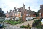 15 and 17 East Cross |
| Leacon Hall | Warehorne | House | 1708 | 10 August 1988 | TQ9866333087 51°03′46″N 0°50′02″E |
1185579 | |
| Digges Court | Westwell | Hall house | 16th century and later | 10 October 1980 | TQ9732447780 51°11′43″N 0°49′22″E |
1071333 | 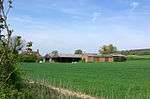 Digges Court |
| The Stocks Windmill | Wittersham | Windmill | Dated 1781 | 4 June 1952 | TQ9130427305 51°00′48″N 0°43′33″E |
1323124 | 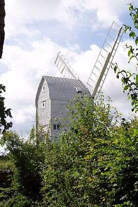 The Stocks Windmill |
| Diamond House | Woodchurch | House | Late 16th century to early 17th century | 9 August 1979 | TQ9249633692 51°04′13″N 0°44′46″E |
1362980 | 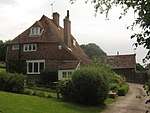 Diamond House |
| Hendon Place | The Green, Woodchurch | Clothiers house | 15th century | 4 June 1952 | TQ9437334911 51°04′50″N 0°46′25″E |
1121861 | 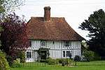 Hendon Place |
| Robhurst | Woodchurch | Wealden house | 16th century or earlier | 16 August 1962 | TQ9182534657 51°04′45″N 0°44′14″E |
1337002 | |
| Shirley Farmhouse | Woodchurch | Farmhouse | 16th century or earlier | 9 August 1979 | TQ9318332532 51°03′35″N 0°45′19″E |
1123740 | |
| Woodchurch Windmill | Woodchurch | Windmill | Early 18th century | 16 August 1962 | TQ9430335215 51°05′00″N 0°46′22″E |
1121143 | 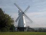 Woodchurch Windmill |
| Old Swan House | Wye with Hinxhill | Continuous jetty house | 15th century | 27 November 1957 | TR0526446706 51°10′58″N 0°56′08″E |
1365318 | |
| Spring Grove and walled garden attached | Wye with Hinxhill | House | 1674 | 13 October 1952 | TR0425046687 51°10′58″N 0°55′16″E |
1216831 | |
| The Old Flying Horse Inn | Wye with Hinxhill | House | 16th century | 27 November 1957 | TR0548046804 51°11′01″N 0°56′20″E |
1216805 | |
| The Old Manor House | Wye with Hinxhill | House | Late 16th century | 27 November 1957 | TR0541346815 51°11′01″N 0°56′16″E |
1216736 | |
| The Wheel House (Junior Common Room), walls and gates attached | Wye with Hinxhill | House | 15th century | 27 November 1957 | TR0549246833 51°11′02″N 0°56′20″E |
1275530 | |
| Wye Bridge | Wye with Hinxhill | Bridge | 1638 | 13 October 1952 | TR0486446920 51°11′05″N 0°55′48″E |
1234208 | 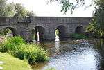 Wye Bridge |
| Yew Trees | Wye with Hinxhill | Continuous jetty house | c.1600 | 13 October 1952 | TR0570946760 51°10′59″N 0°56′31″E |
1217546 | 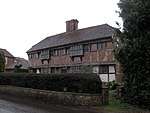 Yew Trees |
.jpg)
Notes
- The date given is the date used by Historic England as significant for the initial building or that of an important part in the structure's description.
- Sometimes known as OSGB36, the grid reference is based on the British national grid reference system used by the Ordnance Survey.
- The "List Entry Number" is a unique number assigned to each listed building and scheduled monument by Historic England.
External links
This article is issued from Wikipedia. The text is licensed under Creative Commons - Attribution - Sharealike. Additional terms may apply for the media files.