Grade II* listed buildings in Braintree (district)
There are over 20,000 Grade II* listed buildings in England. This page is a list of these buildings in the district of Braintree in Essex.
List of buildings
| Name | Location | Type | Completed [note 1] | Date designated | Grid ref.[note 2] Geo-coordinates |
Entry number [note 3] | Image |
|---|---|---|---|---|---|---|---|
| Street Farmhouse | Ashen | House | Early 16th century | 7 August 1952 | TL7468342380 52°03′08″N 0°32′46″E |
1123004 |  |
| Bevingdon House | Belchamp Otten | House | c.1772 | 7 August 1952 | TL8135142128 52°02′52″N 0°38′36″E |
1308998 | 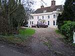 Bevingdon House |
| Belchamp Hall, including outbuilding at rear | Belchamp Walter | Country house | c.1720 | 12 November 1955 | TL8264240688 52°02′04″N 0°39′40″E |
1169581 | 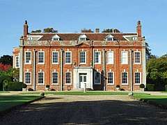 Belchamp Hall, including outbuilding at rear |
| Barn approximately 25 metres north north east of Birdbrook Hall | Birdbrook | Barn | 17th century | 16 May 1984 | TL7072241274 52°02′37″N 0°29′17″E |
1122347 | |
| Eagle Farm Cottages | Birdbrook | Farmhouse | 19th century | 7 August 1952 | TL7244942777 52°03′24″N 0°30′50″E |
1122345 | 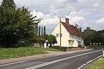 Eagle Farm Cottages |
| Parish Church of St Augustine | Birdbrook | Parish church | Late 11th/early 12th century | 21 June 1962 | TL7067041150 52°02′33″N 0°29′14″E |
1317398 | 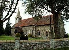 Parish Church of St Augustine |
| Card's | Black Notley | House | Late 15th/early 16th century | 9 May 1979 | TL7449720266 51°51′13″N 0°31′56″E |
1122806 | 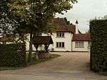 Card's |
| Church of St Peter and St Paul | Black Notley | Parish church | 12th century | 21 December 1967 | TL7614720722 51°51′26″N 0°33′23″E |
1147111 | 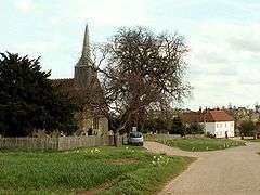 Church of St Peter and St Paul |
| Church of St Mary the Virgin, Pattiswick (redundant) | Pattiswick, Bradwell Juxta Coggeshall | House | Mid-13th century | 21 December 1967 | TL8167124041 51°53′07″N 0°38′18″E |
1168451 | 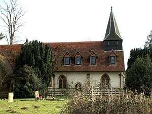 Church of St Mary the Virgin, Pattiswick (redundant) |
| Butlers Hall Farmhouse | Bulmer | Farmhouse | 15th century | 7 August 1952 | TL8361837408 52°00′17″N 0°40′25″E |
1169693 | .jpg) Butlers Hall Farmhouse |
| Parsonage Hall | Bures Hamlet | Farmhouse | 15th century | 7 August 1952 | TL9009833710 51°58′10″N 0°45′57″E |
1122842 | |
| Castle Hedingham United Reformed Church | Castle Hedingham | Congregational chapel | c.1842 | 15 October 1984 | TL7840535390 51°59′18″N 0°35′48″E |
1122952 | |
| Hedingham Castle House | Castle Hedingham | House | c. 1718–19 | 21 June 1962 | TL7879435889 51°59′34″N 0°36′10″E |
1122962 | 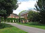 Hedingham Castle House |
| Hedingham Castle, bridge spanning dry moat between inner and outer baileys and including attached retaining wall to north west | Castle Hedingham | Moat | c.1496 | 21 June 1962 | TL7875235881 51°59′33″N 0°36′08″E |
1122960 | 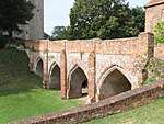 Hedingham Castle, bridge spanning dry moat between inner and outer baileys and including attached retaining wall to north west |
| The Vicarage, including section of curved wall attached to left and right of house | Castle Hedingham | House | 18th century | 21 June 1952 | TL7846535439 51°59′19″N 0°35′52″E |
1338045 | |
| Chapel Hotel | Coggeshall | Cross-wing house | Late 14th century | 31 October 1966 | TL8500422610 51°52′17″N 0°41′09″E |
1337968 | |
| Cooperative Stores | Coggeshall | Timber-framed house | c.1600 | 2 May 1953 | TL8515222737 51°52′21″N 0°41′17″E |
1337951 | |
| Creag Dhu | Coggeshall | Timber-framed house | 14th/15th century | 31 October 1966 | TL8516322715 51°52′20″N 0°41′18″E |
1306727 | |
| Houchin's Farmhouse | Coggeshall | Farmhouse | c.1590 | 2 May 1953 | TL8708423548 51°52′45″N 0°43′00″E |
1123187 | |
| Langan's Restaurant premises 35 yards north of junction of Church Street and Stoneham Street | Coggeshall | House | 15th century | 2 May 1953 | TL8501522651 51°52′18″N 0°41′10″E |
1306051 | |
| Part of the White Hart Hotel | Coggeshall | Timber-framed house | 15th century | 2 May 1953 | TL8500622539 51°52′15″N 0°41′09″E |
1123119 | 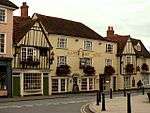 Part of the White Hart Hotel |
| Royal Oak | Coggeshall | Jettied house | Early 17th century | 31 October 1966 | TL8495422787 51°52′23″N 0°41′07″E |
1123101 | |
| The Cricketers Public House | Coggeshall | Market hall | Late 14th century | 24 June 1983 | TL8492522526 51°52′14″N 0°41′05″E |
1337596 | |
| The Fleece Public House | Coggeshall | Timber-framed house | 15th century | 2 May 1953 | TL8477622498 51°52′14″N 0°40′57″E |
1123893 | 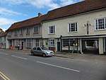 The Fleece Public House |
| The Old Bull | Coggeshall | Cross-wing house | 16th century | 31 October 1966 | TL8515922761 51°52′22″N 0°41′18″E |
1168720 | |
| The Woolpack Inn | Coggeshall | Cross-wing house | 14th century | 2 May 1953 | TL8529922942 51°52′27″N 0°41′25″E |
1168802 | 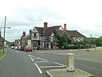 The Woolpack Inn |
| 15, Grange Hill | Coggeshall | Abbey | Late 14th century | 13 May 1975 | TL8499222191 51°52′03″N 0°41′08″E |
1123111 | |
| 47, 49 and 51 Queen Street | Coggeshall | Timber-framed house | Early 17th century | 31 October 1966 | TL8522122889 51°52′26″N 0°41′21″E |
1123128 | |
| 14 and 15, Market Hill | Coggeshall | House | c. 1600 | 31 October 1966 | TL8502522588 51°52′16″N 0°41′10″E |
1170113 | |
| 6 and 6a, East Street | Coggeshall | Flats | Late 14th to early 16th century | 31 October 1966 | TL8504822555 51°52′15″N 0°41′12″E |
1123146 | |
| 14, East Street | Coggeshall | Cross-wing house | 15th/early 16th century | 2 May 1953 | TL8508222556 51°52′15″N 0°41′13″E |
1123147 | |
| 52 and 54, Church Street | Coggeshall | Timber-framed house | 1565 | 31 October 1966 | TL8519922763 51°52′22″N 0°41′20″E |
1169046 | |
| 1, Brickhouse Road | Colne Engaine | House | 16th century | 3 February 1986 | TL8559930754 51°56′40″N 0°41′56″E |
1337910 | |
| Boundary wall to south, east and north-east of Colne Priory | Earls Colne | Boundary wall | Early 15th century | 21 June 1962 | TL8654828807 51°55′35″N 0°42′42″E |
1123234 | 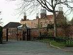 Boundary wall to south, east and north-east of Colne Priory |
| Granary/stables block 70 metres south of Cressing Temple Farmhouse | Cressing Temple | Timber-framed granary | Late 16th century | 21 December 1967 | TL7991118632 |
1123867 | 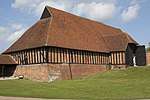 Granary/stables block 70 metres south of Cressing Temple Farmhouse |
| Newneys Farmhouse | Fairstead | House | 15th century | 13 March 1986 | TL7494316543 51°49′12″N 0°32′13″E |
1123450 | |
| Troys Hall | Fairstead | House | 16th century | 2 May 1953 | TL7752716973 51°49′23″N 0°34′28″E |
1123457 | |
| Little Troys | Faulkbourne | House | Late 16th century | 13 March 1986 | TL7902316355 51°49′02″N 0°35′45″E |
1123462 | |
| Ancillary building 6 metres south-east of Feeringbury Manor | Feering | Chapel | 15th century | 21 December 1967 | TL8635821543 51°51′41″N 0°42′18″E |
1123828 | |
| Cobham Oak Cottages | Feering | Aisled house | 1250–1300 | 22 January 1986 | TL8720619596 51°50′37″N 0°42′58″E |
1123836 | |
| Feering House | Feering | House | 14th–16th century | 21 December 1967 | TL8664119304 51°50′28″N 0°42′28″E |
1123833 | |
| Feeringbury Manor | Feering | Aisled house | c.1300 | 2 May 1953 | TL8633121558 51°51′41″N 0°42′17″E |
1306710 | 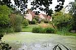 Feeringbury Manor |
| Sun Cottage | Feering | House | 15th century | 21 December 1967 | TL8661919286 51°50′28″N 0°42′27″E |
1337605 | |
| The Sun Inn | Feering | Country house | Early 16th century | 2 May 1953 | TL8661319280 51°50′27″N 0°42′27″E |
1123832 | 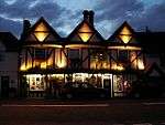 The Sun Inn |
| Barn approximately 25 metres west of Nortofts Farmhouse | Finchingfield | Barn | 17th century | 21 December 1967 | TL7048031579 51°57′24″N 0°28′47″E |
1123492 | |
| Springmede | Finchingfield | Timber-framed house | Early 17th century | 21 December 1967 | TL6847632874 51°58′08″N 0°27′04″E |
1122724 | |
| Church of St Peter and St Paul | Foxearth | Parish church | c.1350 | 21 June 1962 | TL8358144765 52°04′15″N 0°40′38″E |
1216708 | 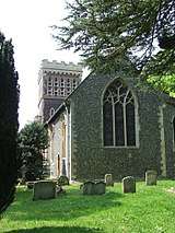 Church of St Peter and St Paul |
| Foxearth Hall | Foxearth | Cross-wing house | Late 15th/early 16th century | 7 August 1952 | TL8326744943 52°04′21″N 0°40′21″E |
1338318 | |
| Gestingthorpe Hall | Gestingthorpe | House | 17th century or earlier | 7 August 1952 | TL8103838652 52°01′00″N 0°38′13″E |
1307107 | |
| Moat Farmhouse | Gestingthorpe | Farmhouse | Late 14th century | 7 August 1952 | TL8159136824 52°00′01″N 0°38′38″E |
1337982 | 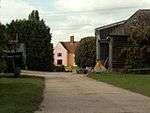 Moat Farmhouse |
| Highgates Cottages | Gosfield | House | Early 15th century or earlier | 7 August 1952 | TL7810429538 51°56′09″N 0°35′22″E |
1122936 | |
| Barn approximately 60 metres SSW of Great Bardfield Hall | Great Bardfield | Aisled barn | Early 14th century | 17 May 1985 | TL6773230184 51°56′42″N 0°26′20″E |
1337760 | |
| Bridge & Great Bardfield Watermill | Great Bardfield | Bridge & watermill | Early 19th century | 21 December 1967 | TL6799831150 51°57′12″N 0°26′36″E |
1337813 | .jpg) Bridge & Great Bardfield Watermill |
| Gobions | Great Bardfield | House | 16th century | 21 December 1967 | TL6745430466 51°56′51″N 0°26′06″E |
1123473 | |
| Great Lodge | Great Bardfield | House | Early 17th century | 2 May 1953 | TL6942929048 51°56′03″N 0°27′47″E |
1123499 | |
| Place House | Great Bardfield | House | 18th century | 2 May 1953 | TL6741030339 51°56′47″N 0°26′04″E |
1337792 | |
| Rear wing of Bank House | Great Bardfield | Guildhall | Late 15th century | 21 December 1967 | TL6753030562 51°56′54″N 0°26′10″E |
1123478 | |
| 6, 7 and 8 Brook Street | Great Bardfield | House | 15th century | 21 December 1967 | TL6767530554 51°56′54″N 0°26′18″E |
1123467 | |
| Parish Church of St Mary | Great Henny | Parish church | Late 11th/12th century | 21 June 1962 | TL8675037786 52°00′26″N 0°43′10″E |
1123259 | 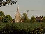 Parish Church of St Mary |
| Dyne's Hall | Great Maplestead | House | Late 17th century | 7 August 1952 | TL8055433070 51°58′00″N 0°37′37″E |
1168338 | 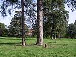 Dyne's Hall |
| Barn adjoining road and approximately 50 metres north of Piccott's Farmhouse | Great Saling | Barn | Early 15th century | 2 January 1985 | TL7083225696 51°54′13″N 0°28′54″E |
1122786 | |
| Church of St James | Great Saling | Parish church | 14th century | 21 December 1967 | TL6999925805 51°54′17″N 0°28′11″E |
1147381 | .jpg) Church of St James |
| Saling Hall | Great Saling | House | Late 17th century | 2 May 1953 | TL6999825856 51°54′19″N 0°28′11″E |
1147360 | 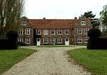 Saling Hall |
| The Old Rectory | Great Yeldham | House | 15th century | 7 August 1952 | TL7567738750 52°01′10″N 0°33′32″E |
1338029 | |
| The White Hart Public House | Great Yeldham | House | c.1500 | 7 August 1952 | TL7617637753 52°00′37″N 0°33′56″E |
1123017 | 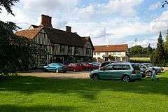 The White Hart Public House |
| Bluebridge House | Greenstead Green and Halstead Rural | House | Early and late 18th century | 7 August 1952 | TL8264929720 51°56′10″N 0°39′20″E |
1337934 | |
| Stanstead Hall | Greenstead Green and Halstead Rural | House | Mid-16th century | 7 August 1952 | TL8269228880 51°55′42″N 0°39′21″E |
1170482 | |
| Holy Trinity Church | Halstead | Church | 1843–44 | 16 March 1978 | TL8083730478 51°56′36″N 0°37′47″E |
1122421 | |
| Old Townford Mill | Halstead | Mill | 1807 | 24 February 1950 | TL8129830396 51°56′33″N 0°38′10″E |
1122457 | .jpg) Old Townford Mill |
| Trinity House | Halstead | House | Mid-17th century | 24 February 1950 | TL8094130499 51°56′37″N 0°37′52″E |
1122420 | 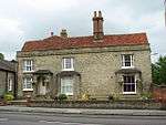 Trinity House |
| 22 and 24, High Street | Halstead | House | Latter half 18th century | 24 February 1950 | TL8140530686 51°56′42″N 0°38′17″E |
1338312 | 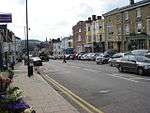 22 and 24, High Street |
| 26, High Street | Halstead | Chantry college | 1411 | 24 February 1950 | TL8138930678 51°56′42″N 0°38′16″E |
1169344 | 26, High Street |
| Hatfield Place | Hatfield Peverel | House | 1791–95 | 13 March 1986 | TL7852411443 51°46′23″N 0°35′10″E |
1337808 | |
| Parish Church of St Andrew | Hatfield Peverel | Parish church | Late 15th/early 16th century | 13 March 1986 | TL7970111017 51°46′08″N 0°36′11″E |
1308736 | 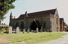 Parish Church of St Andrew |
| Termitts Farmhouse | Hatfield Peverel | Farmhouse | 15th century | 7 May 1976 | TL7903513349 51°47′25″N 0°35′40″E |
1123403 | |
| The Crown Public House | Hatfield Peverel | House | 15th century | 13 March 1986 | TL7873811604 51°46′28″N 0°35′22″E |
1337810 | |
| The Priory | Hatfield Peverel | House | c.1750 | 18 May 1978 | TL7962910854 51°46′03″N 0°36′07″E |
1308731 | |
| Boblow House | Helions Bumpstead | House | 16th century | 21 June 1962 | TL6530940515 52°02′18″N 0°24′31″E |
1122356 | |
| Parish Church of St Andrew | Helions Bumpstead | Parish church | 13th century | 21 June 1962 | TL6513641664 52°02′56″N 0°24′24″E |
1338347 | 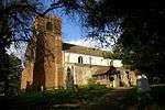 Parish Church of St Andrew |
| Parsonage House | Helions Bumpstead | House | Late 16th century | 21 June 1962 | TL6589942448 52°03′20″N 0°25′06″E |
1165334 | |
| Bridgefoot House | Kelvedon | House | Late 16th century | 2 May 1953 | TL8611718055 51°49′48″N 0°41′59″E |
1337648 | |
| Chambers & Dormers & Gables | High St, Kelvedon | House | 16th/17th century | 2 May 1953 | TL8639619103 51°50′22″N 0°42′15″E |
1170862 | |
| Easterford Mill | Kelvedon | Watermill | 18th century | 21 December 1967 | TL8669419069 51°50′20″N 0°42′31″E |
1171251 | 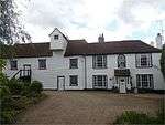 Easterford Mill |
| Hole Farmhouse | Kelvedon | House | 19th century | 29 July 1988 | TL8484017216 51°49′23″N 0°40′50″E |
1123803 | |
| Numbers 180A, B and C, and wing to east in Swan Street | Kelvedon | House | 16th century | 2 May 1953 | TL8648519173 51°50′24″N 0°42′20″E |
1337625 | 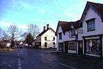 Numbers 180A, B and C, and wing to east in Swan Street |
| Orchard House and Post Office | Kelvedon | House | 15th/early 16th century | 2 May 1953 | TL8636719065 51°50′21″N 0°42′14″E |
1170818 | 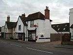 Orchard House and Post Office |
| Red House | Kelvedon | House | 16th/17th century | 2 May 1953 | TL8578018515 51°50′04″N 0°41′42″E |
1169951 | .jpg) Red House |
| St Mary's House | Kelvedon | House | 15th century | 25 June 1974 | TL8595218377 51°49′59″N 0°41′51″E |
1305733 | 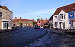 St Mary's House |
| 26–30 High Street | Kelvedon | House | Late 16th century | 25 June 1974 | TL8599618524 51°50′04″N 0°41′53″E |
1337621 | |
| Round Hill House | Lamarsh | House | Early 16th century | 21 June 1962 | TL8857336834 51°59′53″N 0°44′44″E |
1122858 | |
| Glebe House | Liston | House | 14th century | 17 May 1984 | TL8530444381 52°04′00″N 0°42′07″E |
1122336 | |
| Church of St John the Baptist | Little Maplestead, Braintree | Parish church | c.1340 | 21 June 1962 | TL8224833997 51°58′28″N 0°39′07″E |
1338017 | 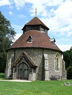 Church of St John the Baptist |
| Church of St Mary the Virgin | Ovington | Parish church | 12th century | 21 June 1962 | TL7632742559 52°03′12″N 0°34′13″E |
1277192 | 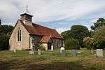 Church of St Mary the Virgin |
| Barn 80 metres WNW of Great Priory Farmhouse | Panfield | Barn | 15th century | 25 November 1983 | TL7359225865 51°54′15″N 0°31′19″E |
1337829 | |
| Parish Church of St Mary the Virgin | Panfield | Church | 15th century | 21 December 1967 | TL7386025344 51°53′58″N 0°31′32″E |
1123400 | 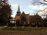 Parish Church of St Mary the Virgin |
| Marvel's Garden | Pebmarsh | House | c.1400 | 12 November 1984 | TL8504232704 51°57′43″N 0°41′31″E |
1122833 | |
| World's End Farmhouse | Pebmarsh | House | c.1570 | 7 August 1952 | TL8416532163 51°57′27″N 0°40′44″E |
1308939 | |
| Larks in the Wood | Pentlow | House | Late 15th/early 16th century | 7 August 1952 | TL8059344985 52°04′26″N 0°38′01″E |
1232780 | |
| Pannels Ash Farmhouse | Pentlow | Farmhouse | 13th century | 21 June 1962 | TL7971544295 52°04′04″N 0°37′14″E |
1277133 | |
| Pentlow Hall | Pentlow | Jettied house | 15th century | 7 August 1952 | TL8120646241 52°05′05″N 0°38′36″E |
1232611 | |
| Pentlow Street Farmhouse | Pentlow Street, Pentlow | Farmhouse | Late 15th century | 17 May 1984 | TL8204945878 52°04′53″N 0°39′19″E |
1232705 | 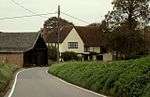 Pentlow Street Farmhouse |
| Rayne Hall | Rayne Hall Green, Rayne | House | Late 15th century | 2 May 1953 | TL7321722962 51°52′42″N 0°30′54″E |
1147693 | |
| Appletrees | Ridgewell | House | 16th century | 24 September 1976 | TL7363041056 52°02′27″N 0°31′49″E |
1338373 | |
| Hill Farmhouse | Ridgewell | House | Late 16th century | 7 August 1952 | TL7445441026 52°02′25″N 0°32′32″E |
1338336 | |
| Little Meadowend | Ridgewell | House | c.1600 | 16 May 1984 | TL7470540290 52°02′01″N 0°32′44″E |
1122314 | |
| Oak Cottage and The Nook | Ridgewell | House | Early 16th century | 21 June 1962 | TL7380340920 52°02′22″N 0°31′58″E |
1122322 | |
| The Mill House | Ridgewell | House | 16th century | 16 May 1984 | TL7329640785 52°02′18″N 0°31′31″E |
1317177 | |
| Rivenhall Place | Rivenhall | House | 16th century | 1 March 1950 | TL8198219016 51°50′24″N 0°38′25″E |
1122598 | |
| Garretts | Shalford | House | c.1600 | 21 December 1967 | TL7177027240 51°55′02″N 0°29′46″E |
1147765 | |
| Redfants Manor | Shalford | House | Mid-16th century | 2 May 1953 | TL7138429638 51°56′20″N 0°29′30″E |
1123379 | |
| Alderford Mill | Sible Hedingham | Watermill | 18th century | 21 June 1962 | TL7848233918 51°58′30″N 0°35′50″E |
1122888 | 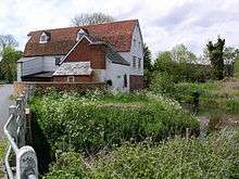 Alderford Mill |
| Church of St Peter | Sible Hedingham | Parish church | 14th century | 21 June 1962 | TL7757034363 51°58′46″N 0°35′03″E |
1122897 | 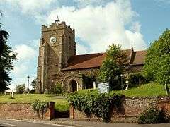 Church of St Peter |
| Greys Hall | Sible Hedingham | House | c.1714 | 21 June 1962 | TL7766034397 51°58′47″N 0°35′08″E |
1276585 | |
| The Old Rectory | Sible Hedingham | House | c.1714 | 7 August 1952 | TL7766734234 51°58′41″N 0°35′08″E |
1233454 | |
| The former Red Lion Public House | Stambourne | House | c. 1500 | 7 August 1952 | TL7208638794 52°01′15″N 0°30′24″E |
1317140 | .jpg) The former Red Lion Public House |
| Brick House | Steeple Bumpstead | House | 19th century | 7 August 1952 | TL6820441648 52°02′52″N 0°27′05″E |
1338387 | |
| Latchleys Farmhouse | Steeple Bumpstead | Farmhouse | 17th/18th century | 7 August 1952 | TL6712439598 52°01′47″N 0°26′05″E |
1338362 | 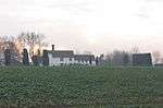 Latchleys Farmhouse |
| The Ancient House | Steeple Bumpstead | House | 16th century | 21 June 1962 | TL6808941129 52°02′35″N 0°26′58″E |
1122307 | |
| The Gun House | Steeple Bumpstead | House | Late 16th century | 7 August 1952 | TL6795641029 52°02′32″N 0°26′51″E |
1122308 | |
| The Moot Hall | Steeple Bumpstead | Moot hall | Late 16th century | 7 August 1952 | TL6801741052 52°02′33″N 0°26′54″E |
1146551 |  The Moot Hall |
| Baytree Farmhouse | Stisted | Farmhouse | Early 16th century | 2 May 1953 | TL7916223354 51°52′48″N 0°36′06″E |
1171048 | |
| Kentishes Farmhouse | Stisted | Farmhouse | Late 16th century | 2 May 1953 | TL7911926235 51°54′21″N 0°36′09″E |
1123898 | |
| Stisted Hall | Stisted | Country house | 1823–25 | 6 September 1988 | TL7951224667 51°53′30″N 0°36′26″E |
1170996 | |
| The Linnetts | Sturmer | House | Late 15th/early 16th century | 16 May 1984 | TL7048343497 52°03′49″N 0°29′08″E |
1338393 | |
| Kendalls | Terling | Timber-framed house | Mid-16th century | 13 March 1986 | TL7664014915 51°48′18″N 0°33′38″E |
1337801 | |
| Owls Hill House | Terling | Cross-wing house | Late 14th century | 13 March 1986 | TL7697315077 51°48′23″N 0°33′56″E |
1337824 | |
| Parish Church of All Saints | Terling | Parish church | Early 13th century | 13 March 1986 | TL7731614817 51°48′14″N 0°34′13″E |
1123411 | 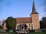 Parish Church of All Saints |
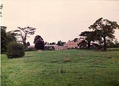
| Terling Place | Terling | Country house | 1772–73 | 2 May 1953 | TL7736714625 51°48′08″N 0°34′16″E |
1123407 | |
| Terling Stores and Post Office | Terling | Cross-wing house | Late 14th century | 13 March 1986 | TL7732714960 51°48′19″N 0°34′14″E |
1147405 | .jpg) Terling Stores and Post Office |
| The Old Vicarage | Terling | Jettied house | 14th/15th century | 13 March 1986 | TL7702315050 51°48′22″N 0°33′59″E |
1308470 | 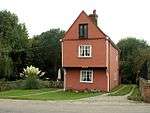 The Old Vicarage |
| Tudor House | Terling | Cross-wing house | 16th century | 13 March 1986 | TL7732514872 51°48′16″N 0°34′14″E |
1147379 | 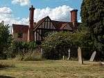 Tudor House |
| United Reformed Church | Terling | Congregational chapel | 1752–53 | 13 March 1986 | TL7724914867 51°48′16″N 0°34′10″E |
1123410 | 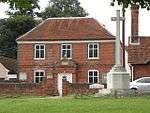 United Reformed Church |
| Vine Cottage and Church View | Terling | Jettied house | 14th century | 13 March 1986 | TL7727314878 51°48′16″N 0°34′11″E |
1308572 | |
| Tilbury Hall | Tilbury Juxta Clare | House | 18th/19th century | 7 August 1952 | TL7583440069 52°01′52″N 0°33′42″E |
1122988 | |
| Bradfields | Harrow Hill, Toppesfield | Farmhouse | Mainly 16th century | 7 August 1952 | TL7259736555 52°00′02″N 0°30′46″E |
1122999 | |
| Olivers Farmhouse | Toppesfield | Farmhouse | Late 16th century | 7 August 1952 | TL7448036750 52°00′06″N 0°32′25″E |
1122997 | |
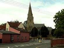
| Church of St John the Evangelist | Twinstead | Parish church | 1859–60 | 21 June 1962 | TL8611936697 51°59′51″N 0°42′35″E |
1306308 | 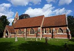 Church of St John the Evangelist |
| Boydell's Farmhouse | Wethersfield | House | 16th century | 2 May 1953 | TL7215129897 51°56′27″N 0°30′11″E |
1337870 | |
| Great Codham Hall | Wethersfield | House | 16th century | 21 December 1967 | TL7382528058 51°55′26″N 0°31′35″E |
1337873 | |
| Littleacres | Wethersfield | House | 18th/19th century | 19 March 1986 | TL7358231571 51°57′20″N 0°31′29″E |
1337872 | |
| Simm's Farmhouse | Wethersfield | House | 16th century or earlier | 21 December 1967 | TL7120931003 51°57′04″N 0°29′24″E |
1123356 | |
| Spice's Farmhouse | Wethersfield | House | 16th/17th century | 21 December 1967 | TL7300829379 51°56′10″N 0°30′55″E |
1306774 | |
| St George's House | Wethersfield | House | c.1600 | 21 December 1967 | TL7117531296 51°57′14″N 0°29′22″E |
1337878 | |
| The Priest House | Wethersfield | Continuous jetty house | Early 16th century | 21 December 1967 | TL7303429348 51°56′09″N 0°30′56″E |
1123312 | _(geograph_3513623).jpg) The Priest House |
| Valley Farmhouse | Wethersfield | Farmhouse | Early 16th century | 21 December 1967 | TL7288229809 51°56′24″N 0°30′49″E |
1123308 | |
| Wright's Farmhouse | Wethersfield | Farmhouse | 14th century | 18 May 1978 | TL7393131278 51°57′10″N 0°31′47″E |
1168807 | |
| Baggarett's Farmhouse | White Colne | Farmhouse | 16th century | 10 April 1987 | TL8711431933 51°57′16″N 0°43′18″E |
1123184 | |
| Colneford House | White Colne | House | 1685 | 7 August 1952 | TL8681929068 51°55′44″N 0°42′57″E |
1337920 | |
| Parish Church of St Andrew | White Colne | Parish church | 12th century | 21 June 1962 | TL8797529946 51°56′11″N 0°43′59″E |
1170815 | .jpg) Parish Church of St Andrew |
| White Notley Hall | White Notley | House | 16th century | 2 May 1953 | TL7842818344 51°50′07″N 0°35′18″E |
1122738 | |
| Catley Cross House | Wickham St. Paul | Cross passage house | Last quarter 16th century | 19 July 1984 | TL8449735602 51°59′18″N 0°41′08″E |
1338002 | |
| Church of All Saints | Wickham St. Paul | Parish church | 14th century | 21 June 1962 | TL8271337133 52°00′09″N 0°39′37″E |
1168870 | 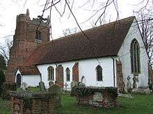 Church of All Saints |
| Avenue House and Newbury House | Witham | House | 1757 | 1 March 1950 | TL8226014769 51°48′07″N 0°38′31″E |
1122576 | |
| Freebourne's House | Witham | House | Largely 17th century | 1 March 1950 | TL8227014687 51°48′04″N 0°38′31″E |
1306394 | |
| High House | Witham | House | 18th century after 1757 | 1 March 1950 | TL8222914629 51°48′02″N 0°38′29″E |
1122587 | |
| Midland Bank | Witham | House | 18th century | 1 March 1950 | TL8211514464 51°47′57″N 0°38′23″E |
1122591 | |
| Roslyn House | Witham | House | 18th century | 1 March 1950 | TL8224414721 51°48′05″N 0°38′30″E |
1338220 | |
| Spread Eagle Hotel | Witham | Jettied house | 15th century | 1 March 1950 | TL8213814494 51°47′58″N 0°38′24″E |
1122590 | 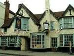 Spread Eagle Hotel |
| 23–27, Bridge Street | Witham | Jettied house | Early 16th century | 1 March 1950 | TL8182114103 51°47′46″N 0°38′07″E |
1122602 | |
| 117 and 119 Newland Street | Witham | House | 18th century | 1 March 1950 | TL8199214313 51°47′52″N 0°38′16″E |
1306348 | |
| 129, Newland Street | Witham | House | 18th century | 1 March 1950 | TL8196714272 51°47′51″N 0°38′15″E |
1338228 | |
| Black Notley Lodge | Notley Road, Braintree | House | Late 17th or early 18th century | 22 March 1957 | TL7592921586 51°51′54″N 0°33′13″E |
1171947 | |
| Bocking Hall | Bocking | House | 17th century | 25 October 1951 | TL7569525754 51°54′09″N 0°33′09″E |
1338237 | |
| Boleyns | Bocking | House | Late 18th century | 25 October 1951 | TL7601324398 51°53′25″N 0°33′23″E |
1170835 | |
| Bradford House | Braintree | Timber-framed house | 18th century | 25 October 1951 | TL7599023740 51°53′04″N 0°33′21″E |
1122543 | |
| Bradford Mill | Bocking | Mill | 18th century | 25 October 1951 | TL7624824328 51°53′23″N 0°33′35″E |
1170364 | 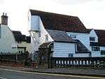 Bradford Mill |
| Church of St Michael | Braintree | Church | 12th–13th century | 25 October 1951 | TL7560722937 51°52′38″N 0°32′59″E |
1338293 | 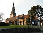 Church of St Michael |
| Dial House Inn | Bocking | House | 1603 | 25 October 1951 | TL7619424284 51°53′21″N 0°33′32″E |
1338247 | |
| Doreward's Hall | Bocking | House | 1579 | 25 October 1951 | TL7626025442 51°53′59″N 0°33′38″E |
1170740 | |
| Georgian House | Bocking | House | 18th century | 25 October 1951 | TL7600323791 51°53′06″N 0°33′21″E |
1170198 | |
| Lyons Hall | Lyons Hall | House | 18th century | 25 October 1951 | TL7756625428 51°53′57″N 0°34′46″E |
1122469 | |
| Maysent House | Bocking | House | c.1691 | 25 October 1951 | TL7601924093 51°53′15″N 0°33′23″E |
1122551 | |
| Swan Inn | Braintree | Inn | Late 16th century | 25 October 1951 | TL7571723134 51°52′45″N 0°33′05″E |
1338242 | |
| The Constitutional Club and Shops | Braintree | House | 18th century | 25 October 1951 | TL7577523096 51°52′43″N 0°33′08″E |
1338263 | |
| The Old Manor House | Braintree | House | 17th century | 25 October 1951 | TL7572523129 51°52′45″N 0°33′06″E |
1338266 | |
| Town Hall including screens and public lavatories adjoining north east and south | Braintree | Town hall | 1926–28 | 27 April 1992 | TL7585423018 51°52′41″N 0°33′12″E |
1235026 | 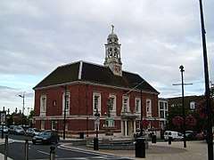 Town Hall including screens and public lavatories adjoining north east and south |
| Wall to the Church of St Mary the Virgin | Bocking | Wall | 16th century | 29 November 1973 | TL7568125660 51°54′06″N 0°33′08″E |
1305850 | 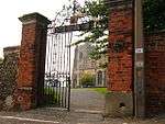 Wall to the Church of St Mary the Virgin |
| Wentworth House | Bocking | House | 1679 | 25 October 1951 | TL7601624078 51°53′15″N 0°33′23″E |
1170324 | |
| 4, Bradford Street | Bocking | Timber-framed house | 18th century | 25 October 1951 | TL7604323806 51°53′06″N 0°33′23″E |
1122553 | |
| 11, Bradford Street | Bocking | House | 18th century | 25 October 1951 | TL7596823705 51°53′03″N 0°33′19″E |
1170171 | |
| 77–81, Bradford Street | Bocking | House | 1590 | 25 October 1951 | TL7601824023 51°53′13″N 0°33′23″E |
1338246 | |
| 75, Bradford Street | Bocking | House | 18th century | 22 March 1957 | TL7602324016 51°53′13″N 0°33′23″E |
1122549 | |
| 114–118, Bradford Street | Bocking | Jettied house | Early 16th century | 25 October 1951 | TL7610924192 51°53′18″N 0°33′28″E |
1305938 | 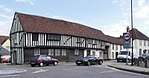 114–118, Bradford Street |
| 35–39 Church Lane | Bocking | House | Late 16th century | 25 October 1951 | TL7596424424 51°53′26″N 0°33′20″E |
1170825 | |
Notes
- The date given is the date used by Historic England as significant for the initial building or that of an important part in the structure's description.
- Sometimes known as OSGB36, the grid reference is based on the British national grid reference system used by the Ordnance Survey.
- The "List Entry Number" is a unique number assigned to each listed building and scheduled monument by Historic England.
External links
![]()
This article is issued from Wikipedia. The text is licensed under Creative Commons - Attribution - Sharealike. Additional terms may apply for the media files.