Grade II* listed buildings in the City of Chelmsford
There are over 20,000 Grade II* listed buildings in England. This page is a list of these buildings in the City of Chelmsford in Essex.
List of buildings
| Name | Location | Type | Completed [note 1] | Date designated | Grid ref.[note 2] Geo-coordinates |
Entry number [note 3] | Image |
|---|---|---|---|---|---|---|---|
| The Old Rectory | Boreham | House | 17th century | 10 April 1967 | TL7557109521 51°45′25″N 0°32′33″E |
1338401 | 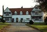 The Old Rectory |
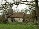
| Church of St Mary the Virgin | Broomfield | Church | Late 11th century | 10 April 1967 | TL7052410473 51°46′01″N 0°28′11″E |
1338425 | 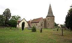 Church of St Mary the Virgin |
| Former Church of St James | Chignal St James, Chignall | House | Late 13th and early 14th century | 10 April 1967 | TL6695209663 51°45′39″N 0°25′04″E |
1122199 | |
| Chobbing's Farmhouse | Chignal St James, Chignall | Farmhouse | Late 14th century | 19 June 1975 | TL6863709414 51°45′29″N 0°26′31″E |
1306286 | 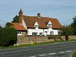 Chobbing's Farmhouse |
| Church of St Nicholas | Chignall Smealy, Chignall | Church | Early 16th century | 10 April 1967 | TL6678711617 51°46′42″N 0°24′59″E |
1170018 | 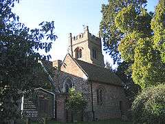 Church of St Nicholas |
| Slough House | Danbury | House | 17th century | 29 December 1952 | TL8051803134 51°41′53″N 0°36′39″E |
1122172 | 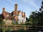 Slough House |
| Willis Farmhouse | East Hanningfield | Farmhouse | Early 16th century | 29 December 1952 | TL7717000799 51°40′41″N 0°33′40″E |
1122177 |  |
| Barn at Great Seabrights Farm | Galleywood | Barn | 18th century | 29 May 1981 | TL7179703852 51°42′26″N 0°29′06″E |
1237350 | 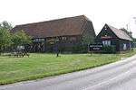 Barn at Great Seabrights Farm |
| Church of St Andrew | Good Easter | Church | c.1200 | 10 April 1967 | TL6264012077 51°47′01″N 0°21′23″E |
1122143 | 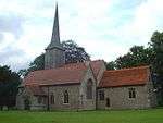 Church of St Andrew |
| Church of St John the Evangelist | Little Leighs, Great and Little Leighs | Church | Early 12th century | 10 April 1967 | TL7189916750 51°49′23″N 0°29′34″E |
1122132 | 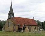 Church of St John the Evangelist |
| The Vicarage | Great Baddow | House | Early 18th century | 19 June 1975 | TL7298004755 51°42′53″N 0°30′09″E |
1170837 | |
| 66 and 68 High Street | Great Baddow | House | 17th century | 10 April 1967 | TL7288004850 51°42′57″N 0°30′04″E |
1170982 | |
| Black Chapel Cottage | North End, Great Waltham | House | Late 15th century | 10 April 1967 | TL6634318187 51°50′15″N 0°24′47″E |
1171938 | 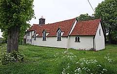 Black Chapel Cottage |
| Bollingtons | Great Waltham | House | 18th century | 29 December 1952 | TL6960213454 51°47′38″N 0°27′29″E |
1122056 | 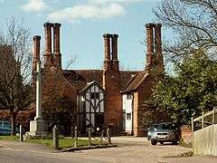 Bollingtons |
| Fitzjohn's Farmhouse | Great Waltham | Farmhouse | 15th century | 10 April 1967 | TL6756613738 51°47′50″N 0°25′43″E |
1171901 | 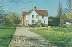 Fitzjohn's Farmhouse |
| Hillhouse Farmhouse | Howe Street, Great Waltham | Farmhouse | 16th century | 29 December 1952 | TL7003915437 51°48′42″N 0°27′55″E |
1338490 | |
| Wisemans | Great Waltham | Jettied house | 16th century | 10 April 1967 | TL6942413501 51°47′40″N 0°27′19″E |
1305525 | |
| Little Baddow Hall | Little Baddow | House | 16th century | 29 December 1952 | TL7644108022 51°44′35″N 0°33′15″E |
1338483 | 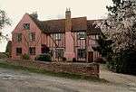 Little Baddow Hall |
| Old Riffhams | Little Baddow | House | Mid-16th century | 29 December 1952 | TL7770506565 51°43′47″N 0°34′18″E |
1122037 | 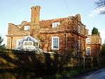 Old Riffhams |
| Brick revetting to moat and octagonal turrets at north-west and south-west angles, Killigrews | Margaretting | Moat | Early 16th century | 10 April 1967 | TL6883502787 51°41′54″N 0°26′30″E |
1152176 | |
| Church of St Margaret | Margaretting | Church | Early–mid-15th century | 10 April 1967 | TL6651200422 51°40′40″N 0°24′25″E |
1338504 | 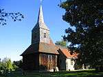 Church of St Margaret |
| Killigrews | Margaretting | House | 1714 | 29 December 1952 | TL6886502777 51°41′54″N 0°26′32″E |
1338505 | |
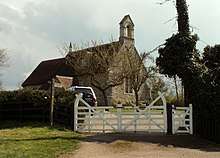
| Church (of no known dedication) | Mashbury | Church | 12th century | 10 April 1967 | TL6515011856 51°46′52″N 0°23′34″E |
1265087 | 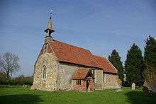 Church (of no known dedication) |
| Church of Holy Trinity | Pleshey | Church | c.1394 | 10 April 1967 | TL6632814297 51°48′09″N 0°24′39″E |
1235569 | 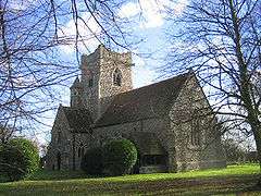 Church of Holy Trinity |
| Church of St Michael and All Angels | Roxwell | Church | 14th century | 10 April 1967 | TL6454608490 51°45′03″N 0°22′56″E |
1235784 | 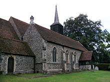 Church of St Michael and All Angels |
| Church of St Andrew | Sandon | Church | 12th century | 10 April 1967 | TL7431104813 51°42′54″N 0°31′19″E |
1235849 | 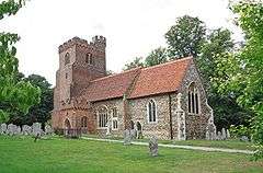 Church of St Andrew |
| The Rectory | Sandon | House | Mid-18th century | 10 April 1967 | TL7424404668 51°42′49″N 0°31′15″E |
1264863 | |
| Church of St Peter | South Hanningfield | Parish church | Late 11th-century or early 12th-century origin | 10 April 1967 | TQ7444698056 51°39′15″N 0°31′13″E |
1236422 | |
| Church of St Mary | Buttsbury, Stock | Church | 14th–15th century | 10 April 1967 | TQ6638498622 51°39′42″N 0°24′15″E |
1264434 | 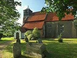 Church of St Mary |
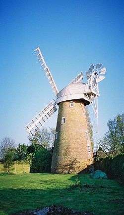
| Stock Windmill | Stock | Tower mill | 18th century | 10 April 1967 | TQ6981598781 51°39′44″N 0°27′14″E |
1264461 | |
| Church of St Mary and St Edward | West Hanningfield | Church | 12th century | 10 April 1967 | TQ7350899825 51°40′13″N 0°30′28″E |
1236738 | 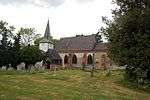 Church of St Mary and St Edward |
| Colevile Hall | West Hanningfield | House | Late 16th century | 10 April 1967 | TL7153600246 51°40′29″N 0°28′46″E |
1236888 | |
| Edwins Hall | Woodham Ferrers and Bicknacre | House | Late 16th century | 29 December 1952 | TQ8115599386 51°39′51″N 0°37′05″E |
1236906 | 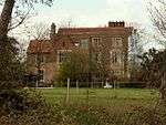 Edwins Hall |
| Barn south-west of Lordship Farm | Writtle | Aisled barn | Late 15th–early 16th century | 19 June 1975 | TL6766606676 51°44′01″N 0°25′36″E |
1264255 | |
| Church of All Saints | Writtle | Church | Late 12th century | 10 April 1967 | TL6775006145 51°43′44″N 0°25′39″E |
1237229 | 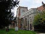 Church of All Saints |
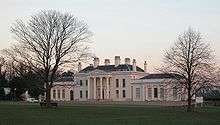
| Hylands House | Hylands Park, Writtle | Country house | c.1728 | 10 April 1967 | TL6848504195 51°42′40″N 0°26′14″E |
1264253 | |
| Moor Hall | Newney Green, Writtle | House | 16th century | 29 December 1952 | TL6498306467 51°43′57″N 0°23′16″E |
1237175 | |
| Church of All Saints | Springfield | Church | Nave c.1100 | 20 May 1949 | TL7195107986 51°44′39″N 0°29′21″E |
1186867 | 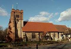 Church of All Saints |
| Lodge Farmhouse | Chelmsford | House | c.1280–1330 | 14 December 1978 | TL6936802736 51°41′52″N 0°26′58″E |
1141329 | |
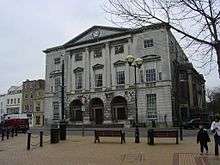
| Shire Hall | Chelmsford | Shire hall | 1790–91 | 20 May 1949 | TL7084406902 51°44′05″N 0°28′22″E |
1141328 | |
| The Old Rectory | Chelmsford | House | 1752 | 20 May 1949 | TL7180707933 51°44′38″N 0°29′14″E |
1263936 | |
| The Old Rectory | Springfield | House | 1752 | 20 May 1949 | TL7181007936 51°44′38″N 0°29′14″E |
1141369 | |
| 26 High Street | Chelmsford | House | Early 18th century | 20 April 1949 | TL7099306733 51°44′00″N 0°28′29″E |
1328766 | |
See also
- Grade II* listed buildings in Essex
- Grade II* listed buildings in Basildon (district)
- Grade II* listed buildings in Braintree (district)
- Grade II* listed buildings in Brentwood (borough)
- Grade II* listed buildings in Castle Point
- Grade II* listed buildings in Colchester (borough)
- Grade II* listed buildings in Epping Forest (district)
- Grade II* listed buildings in Harlow
- Grade II* listed buildings in Maldon (district)
- Grade II* listed buildings in Rochford (district)
- Grade II* listed buildings in Southend-on-Sea
- Grade II* listed buildings in Tendring
- Grade II* listed buildings in Thurrock
- Grade II* listed buildings in Uttlesford
- Grade I listed buildings in Essex
Notes
- The date given is the date used by Historic England as significant for the initial building or that of an important part in the structure's description.
- Sometimes known as OSGB36, the grid reference is based on the British national grid reference system used by the Ordnance Survey.
- The "List Entry Number" is a unique number assigned to each listed building and scheduled monument by Historic England.
External links
![]()
This article is issued from Wikipedia. The text is licensed under Creative Commons - Attribution - Sharealike. Additional terms may apply for the media files.