Grade II* listed buildings in Uttlesford
There are over 20,000 Grade II* listed buildings in England. This page is a list of these buildings in the district of Uttlesford in Essex.
Uttlesford
| Name | Location | Type | Completed [note 1] | Date designated | Grid ref.[note 2] Geo-coordinates |
Entry number [note 3] | Image |
|---|---|---|---|---|---|---|---|
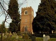
| Church of St Mary the Virgin | Arkesden, Uttlesford | Church | Norman | 21 February 1967 | TL4822534599 51°59′24″N 0°09′26″E |
1170054 | 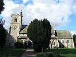 Church of St Mary the Virgin |
| Guildhall | Church End, Ashdon | House | By 1501 | 26 November 1951 | TL5810341465 52°02′57″N 0°18′15″E |
1112492 | 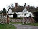 Guildhall |
| Friars Grange Farmhouse | Aythorpe Roding | House | 16th century | 7 February 1952 | TL6038414324 51°48′16″N 0°19′29″E |
1328492 |  Friars Grange Farmhouse |
| Judds Cottage | Keeres Green, Aythorpe Roding | Hall House | Early 14th century | 17 October 1983 | TL5957614275 51°48′16″N 0°18′47″E |
1141300 |  |
| Parish Church of St Mary | Aythorpe Roding | Parish Church | 13th century | 23 February 1967 | TL5843415350 51°48′52″N 0°17′49″E |
1141292 | 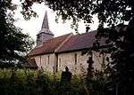 Parish Church of St Mary |
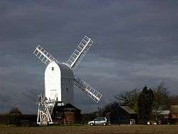
| Aythorpe Roding Windmill | Gunners Green, Aythorpe Roding | Post Mill | Late 18th century | 23 February 1967 | TL5903415159 51°48′45″N 0°18′20″E |
1328785 | |
| Yeomans | Aythorpe Roding | Hall House | 14th century or 15th century | 17 October 1983 | TL6021015756 51°49′03″N 0°19′23″E |
1328786 | |
| Barnston Hall | Barnston | House | 1920 | 7 February 1952 | TL6510819659 51°51′04″N 0°23′45″E |
1322252 | |
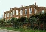
| Barnston Lodge | Barnston | House | Late 18th century | 20 February 1967 | TL6544319666 51°51′04″N 0°24′02″E |
1112886 | .jpg) Barnston Lodge |
| Church of St Andrew | Barnston | Parish Church | c1160-1170 | 20 February 1967 | TL6523219624 51°51′03″N 0°23′51″E |
1308903 | 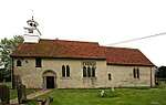 Church of St Andrew |
| The Old Rectory | Barnston | House | 18th century | 20 February 1967 | TL6563719473 51°50′57″N 0°24′12″E |
1322254 | |
| Berden Hall | Berden | House | 16th century | 26 November 1951 | TL4674629505 51°56′41″N 0°08′01″E |
1112468 | |
| Berden Priory | Berden | Farmhouse | 17th century | 26 November 1951 | TL4623830224 51°57′05″N 0°07′35″E |
1112470 | .jpg) Berden Priory |
| Well House and Treadmill to North of Berden Priory | Berden | Donkey Wheel | 17th century | 21 February 1967 | TL4622130257 51°57′06″N 0°07′35″E |
1170289 | |
| Church of St Mary | Birchanger | Church | Early 12th century | 21 February 1967 | TL5073022781 51°53′00″N 0°11′19″E |
1322445 | .jpg) Church of St Mary |
| Barn to East of Church Hall | Church End, Broxted | Aisled Barn | Early 15th century | 20 February 1967 | TL5798127416 51°55′22″N 0°17′45″E |
1112225 | |
| Church Hall | Church End, Broxted | House | Later alterations | 7 February 1952 | TL5791927397 51°55′22″N 0°17′42″E |
1322561 | |
| Church of St Mary the Virgin | Broxted | Church | Early 13th century | 20 February 1967 | TL5784327380 51°55′21″N 0°17′38″E |
1112251 | 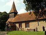 Church of St Mary the Virgin |
| Wood Farmhouse | Brick End, Broxted | Timber Framed House | Early 16th century or earlier | 24 October 1979 | TL5655726551 51°54′56″N 0°16′30″E |
1306916 | |
| Dovecote at Sibley's Farm | Chickney | Dovecote | Later | 7 February 1952 | TL5654429713 51°56′38″N 0°16′34″E |
1322581 | |
| Sibley's Farmhouse | Chickney | Farmhouse | 14th century | 7 February 1952 | TL5655529744 51°56′39″N 0°16′35″E |
1322580 | |
| The Bury | Clavering | House | Pre-Conquest - Norman | 26 November 1951 | TL4714431935 51°57′59″N 0°08′26″E |
1170538 | |
| The Old Hall | Clavering | House | Later | 26 November 1951 | TL4702531724 51°57′52″N 0°08′19″E |
1112414 | |
| 1–5 Church Walk | Clavering | Jettied House | Late 15th century | 21 February 1967 | TL4704431764 51°57′54″N 0°08′20″E |
1112457 | 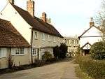 1–5 Church Walk |
| Brick House Farmhouse | Debden | Farmhouse | 15th century | 26 November 1951 | TL5444634094 51°59′02″N 0°14′51″E |
1112375 | |
| New Amberden Hall | Debden Green, Debden | House | c. 1670 | 26 November 1951 | TL5621830513 51°57′04″N 0°16′18″E |
1112407 | |
| Church of St Nicholas | Elmdon | Church | 15th century | 21 February 1967 | TL4619439663 52°02′10″N 0°07′48″E |
1112358 | .jpg) Church of St Nicholas |
| Pigots | Elmdon | Moat | Early 16th century | 21 February 1967 | TL4633739193 52°01′55″N 0°07′54″E |
1322504 | |
| Barn to North West of Waterside Preparatory School, on the West Side of the Yard | Hassobury, Farnham | Barn | c. 1300 | 22 February 1980 | TL4845125220 51°54′21″N 0°09′24″E |
1112313 | |
| Boote House | Felsted | Jettied House | c. 1596 | 7 February 1952 | TL6768620351 51°51′24″N 0°26′01″E |
1308644 | 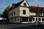 Boote House |
| House Adjoining and now integral with Boote House | Felsted | House | C20 | 7 February 1952 | TL6769020340 51°51′23″N 0°26′01″E |
1112870 | House Adjoining and now integral with Boote House |
| Bury Farm Barn 50 Metres to North West | Felsted | Timber Framed Barn | Late 16th century | 22 May 1978 | TL6757720519 51°51′29″N 0°25′55″E |
1112865 | |
| Hartford End Mill | Hartford End, Felsted | House | Late 18th century | 6 August 1984 | TL6854017322 51°49′45″N 0°26′40″E |
1112855 | 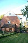 Hartford End Mill |
| Ingrams Close | Felsted | House | c. 1800 | 20 February 1967 | TL6777520417 51°51′26″N 0°26′05″E |
1146667 | |
| Leez Priory Fisherman's Hut | Felsted | House | Mid 16th century | 20 February 1967 | TL7004018593 51°50′24″N 0°28′01″E |
1112816 | |
| Old Schoolmasters House adjacent to Old School to the East | Felsted | Jettied House | Early 16th century | 7 February 1952 | TL6768320367 51°51′24″N 0°26′01″E |
1322255 | 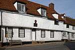 Old Schoolmasters House adjacent to Old School to the East |
| The Pavilion | Felsted | House | Mid 16th century | 6 August 1984 | TL6795820478 51°51′27″N 0°26′15″E |
1112891 | |
| Old Vicarage | Great Chesterford | House | 19th century | 21 February 1967 | TL5064142779 52°03′46″N 0°11′46″E |
1112297 | .jpg) Old Vicarage |
| Brands Farmhouse | Great Dunmow | Farmhouse | 14th century | 7 February 1952 | TL6085719396 51°51′00″N 0°20′02″E |
1098283 | |
| Brook House | Great Dunmow | Kitchen | 16th century | 20 February 1967 | TL6272222412 51°52′36″N 0°21′45″E |
1076533 | |
| Diabold | Great Dunmow | House | Earlier | 20 February 1967 | TL6274521945 51°52′20″N 0°21′45″E |
1328241 | |
| Maltings at Boyes Croft | Great Dunmow | Maltings | Early 16th century | 2 June 1971 | TL6283922034 51°52′23″N 0°21′50″E |
1298840 | |
| Porters Yard | Church End, Great Dunmow | Hall House | 14th century | 20 February 1967 | TL6288522774 51°52′47″N 0°21′54″E |
1121539 | |
| The Chestnuts | Great Dunmow | House | 18th century | 20 February 1967 | TL6269122014 51°52′23″N 0°21′43″E |
1051609 | |
| White Horse Public House | Great Dunmow | Jettied House | Early 14th century | 24 March 1981 | TL6277221964 51°52′21″N 0°21′47″E |
1122660 | |
| 20, 22 and 24 High Street | Great Dunmow | Hall House | Late 14th century | 16 February 1984 | TL6277721888 51°52′19″N 0°21′47″E |
1359637 | |
| War Memorial | Great Dunmow | Cross | 1921 | 14 October 2016 | TL6282521809 57°52′16″N 0°21′49″E |
1438524 | 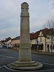 War Memorial |
| Bridgefoot | Great Easton | House | 16th century | 7 February 1952 | TL6038625328 51°54′12″N 0°19′48″E |
1322576 | |
| Church of St John and St Giles | Great Easton | Church | Early 12th century | 20 February 1967 | TL6076025471 51°54′17″N 0°20′08″E |
1112198 | 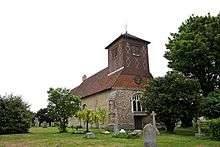 Church of St John and St Giles |
| Elizabeth's Cottage | Great Easton | House | Later | 28 June 1983 | TL6037626893 51°55′03″N 0°19′50″E |
1164926 | |
| Thatched Cottage | Little Cambridge, Great Easton | Hall House | 14th century | 28 June 1968 | TL6197827088 51°55′08″N 0°21′14″E |
1317501 | |
| Church of St Giles | Great Hallingbury | Church | Late 11th century | 20 February 1967 | TL5113719600 51°51′16″N 0°11′35″E |
1147293 | 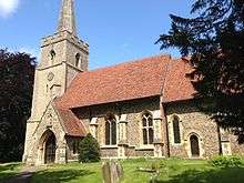 Church of St Giles |
| Barrington Hall | Hatfield Broad Oak | Country House | c. 1734 | 21 July 1975 | TL5497217645 51°50′09″N 0°14′52″E |
1097470 | |
| Forest Cottage | Wood Row, Hatfield Broad Oak | House | Extension | 8 August 1985 | TL5390418797 51°50′48″N 0°13′58″E |
1186299 | |
| Oak Cottage | Broad St, Hatfield Broad Oak | House | C20 | 1 April 1982 | TL5497216439 51°49′30″N 0°14′50″E |
1097482 | 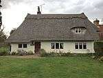 Oak Cottage |
| Old Court House | Hatfield Broad Oak | House | 1985 | 8 August 1985 | TL5456016567 51°49′35″N 0°14′29″E |
1299266 |  Old Court House |
| Ploughden | Bush End, Hatfield Broad Oak | House | 1985 | 8 August 1985 | TL5508519912 51°51′23″N 0°15′02″E |
1186260 |  Ploughden |
| Rundle House | Hatfield Broad Oak | House | Early 19th century | 20 February 1967 | TL5455116512 51°49′33″N 0°14′28″E |
1120880 | 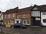 Rundle House |
| Shell House | Hatfield Forest, Hatfield Broad Oak | Garden House | c. 1757 | 8 August 1985 | 49°46′01″N 7°33′26″W | 1186279 | 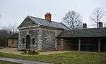 Shell House |
| Town Farmhouse including Wall enclosing Yard | Hatfield Broad Oak | Kitchen | Late 14th century or early 15th century | 7 February 1952 | TL5456716441 51°49′31″N 0°14′29″E |
1120907 | Town Farmhouse including Wall enclosing Yard |
| Ware Pond Cottages | Hatfield Broad Oak | Farmhouse | Early 15th century | 8 August 1985 | TL5505516511 51°49′33″N 0°14′55″E |
1334068 | 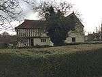 Ware Pond Cottages |
| Down Hall | Hatfield Heath | Country House | 1871-3 | 14 December 1983 | TL5225513108 51°47′45″N 0°12′23″E |
1186292 |  Down Hall |
| Lea Hall | Hatfield Heath | House | Early 17th century | 7 February 1952 | TL5286215357 51°48′57″N 0°12′58″E |
1334062 | |
| Church of St Andrew | Hempstead | Church | Mid 14th century by 1365 | 21 February 1967 | TL6350437996 52°00′59″N 0°22′52″E |
1278485 | 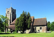 Church of St Andrew |
| Cock and Bell | High Easter | House | Later Alteration | 7 February 1952 | TL6206214773 51°48′29″N 0°20′58″E |
1112509 | .jpg) Cock and Bell |
| High Easterbury | High Easter | House | 14th century | 20 September 1985 | TL6196014668 51°48′26″N 0°20′52″E |
1147300 | |
| Pentlow End | High Easter | Farmhouse | Late 16th century | 20 November 1975 | TL6212816234 51°49′16″N 0°21′03″E |
1112504 | |
| Barn approximately 60 Metres South West of Moat at New Hall Farm | High Roothing | Barn | 17th century | 7 February 1952 | TL5795516158 51°49′18″N 0°17′26″E |
1328813 | |
| Parish Church of All Saints | High Roothing | Parish Church | 13th century | 20 February 1967 | TL5918616523 51°49′29″N 0°18′30″E |
1141272 | 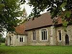 Parish Church of All Saints |
| Church of St John the Evangelist | Upper Green, Langley | Church | 12th century | 21 February 1967 | TL4425935258 51°59′49″N 0°05′59″E |
1278241 | 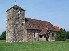 Church of St John the Evangelist |
| Parish Church of St Michael and All Angels | Leaden Roding | Parish Church | 11th century | 20 February 1967 | TL5899813248 51°47′43″N 0°18′15″E |
1328803 | 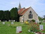 Parish Church of St Michael and All Angels |
| Church of St Mary the Virgin | Lindsell | Parish Church | 12th century | 20 February 1967 | TL6436727122 51°55′06″N 0°23′19″E |
1112140 | 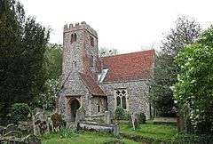 Church of St Mary the Virgin |
| Barn at Little Canfield Hall (50 Metres South West) | Little Canfield | Timber Framed Barn | Late 14th century | 16 February 1984 | TL5850421887 51°52′23″N 0°18′04″E |
1054762 | |
| Stone Hall | Little Canfield | House | 16th century | 16 February 1984 | TL5925222274 51°52′35″N 0°18′43″E |
1334091 | |
| Church of St Mary the Virgin | Little Chesterford | Church | Early 13th century | 21 February 1967 | TL5151441717 52°03′11″N 0°12′30″E |
1277390 | 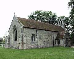 Church of St Mary the Virgin |
| Brick House | Little Dunmow | House | Late C16-early 17th century | 7 May 1952 | TL6552720624 51°51′35″N 0°24′08″E |
1168301 | |
| Grange Farm Granary 60 Metres South of Farmhouse | Little Dunmow | Granary | 15th century or earlier | 20 February 1967 | TL6533821231 51°51′55″N 0°24′00″E |
1251436 | |
| Easton Glebe | Little Easton | House | Mid 18th century | 20 February 1967 | TL6010323866 51°53′25″N 0°19′31″E |
1334055 | |
| Church of St Mary the Virgin | Little Hallingbury | Church | 12th century | 20 February 1967 | TL5032617472 51°50′08″N 0°10′49″E |
1112021 | 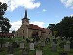 Church of St Mary the Virgin |
| Gaston House | Gaston Green, Little Hallingbury | House | Late 18th century | 20 February 1967 | TL4987217215 51°50′00″N 0°10′25″E |
1322661 |  Gaston House |
| Hallingbury Mill | Little Hallingbury | Flour Mill | 1874 | 13 June 1983 | TL4957616922 51°49′51″N 0°10′09″E |
1111991 | 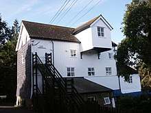 Hallingbury Mill |
| Tewes | Little Sampford | House | 16th century | 26 November 1951 | TL6405733925 51°58′46″N 0°23′14″E |
1231857 | |
| Ring Temple | Audley End Park, Littlebury | Garden Building | 1763 | 21 February 1967 | TL5155938323 52°01′21″N 0°12′27″E |
1231275 | |
| Church of St Mary the Virgin | Manuden | Church | 12th century | 21 February 1967 | TL4910426665 51°55′07″N 0°10′00″E |
1233999 | 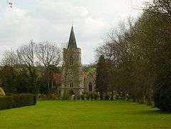 Church of St Mary the Virgin |
| Clock House, North House, South House | Shortgrove, Newport | House | 1980 | 21 February 1967 | TL5267035326 51°59′43″N 0°13′20″E |
1235092 | |
| Crown House | Newport | House | Late 17th century | 26 November 1951 | TL5216834557 51°59′19″N 0°12′53″E |
1234043 | _p25b_-_Nell_Gwynn's_House.jpg) Crown House |
| Monk's Barn | Newport | House | Later | 26 November 1951 | TL5215933938 51°58′59″N 0°12′51″E |
1234841 | 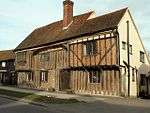 Monk's Barn |
| Newport House | Newport | House | 18th century | 21 February 1967 | TL5212933940 51°58′59″N 0°12′50″E |
1275835 | |
| Old Vicarage | Newport | Jettied House | Early 16th century | 21 February 1967 | TL5213833835 51°58′56″N 0°12′50″E |
1234747 | 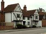 Old Vicarage |
| The Georgians | Newport | House | 18th century | 21 February 1967 | TL5213233801 51°58′55″N 0°12′50″E |
1275909 | |
| Tudor House | Newport | Farmhouse | 15th century | 26 November 1951 | TL5214834622 51°59′21″N 0°12′52″E |
1276293 | |
| Church of St Simon and St Jude | Quendon, Quendon and Rickling | Church | 13th century | 21 February 1967 | TL5154830664 51°57′14″N 0°12′14″E |
1216675 | 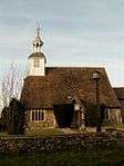 Church of St Simon and St Jude |
| Dovecote to West of Quendon Hall | Quendon Park, Quendon and Rickling | Dovecote | 17th century | 26 November 1951 | TL5145331861 51°57′53″N 0°12′11″E |
1217182 | |
| Forecourt Walls and Gate Piers to South of Quendon Hall | Quendon Park, Quendon and Rickling | Gate Pier | 17th century | 21 February 1967 | TL5154031768 51°57′49″N 0°12′15″E |
1216683 | |
| Quendon Court | Quendon, Quendon and Rickling | House | Medieval | 21 February 1967 | TL5139330238 51°57′00″N 0°12′05″E |
1275800 | .jpg) Quendon Court |
| Rickling Hall | Rickling, Quendon and Rickling | Hall | C14-C15 | 26 November 1951 | TL5003730302 51°57′04″N 0°10′54″E |
1216666 | .jpg) Rickling Hall |
| Church of St Mary the Virgin | The Village, Radwinter | Church | 14th century | 21 February 1967 | TL6063137275 52°00′38″N 0°20′21″E |
1221254 | .jpg) Church of St Mary the Virgin |
| The Old Vicarage | Radwinter | House | Modern | 26 November 1951 | TL6060837237 52°00′37″N 0°20′19″E |
1221273 | _(geograph_4872338).jpg) The Old Vicarage |
| Ashcroft Court | Saffron Walden | House | c. 1800 | 28 November 1951 | 49°46′01″N 7°33′26″W | 1196153 | |
| Barclays Bank | Saffron Walden | Steps | 1874 | 1 November 1972 | TL5389738544 52°01′26″N 0°14′30″E |
1297732 | |
| Bridge House the Corner House | Saffron Walden | House | Early 16th century | 28 November 1951 | TL5354538653 52°01′30″N 0°14′11″E |
1204544 | |
| Burntwood End | Little Walden, Saffron Walden | House | 19th century | 1 November 1972 | TL5414242878 52°03′46″N 0°14′50″E |
1196099 | |
| Commemorative Column north east of Audley End House | Audley End, Saffron Walden | Column | 1774 | 28 November 1951 | TL5267138944 52°01′40″N 0°13′26″E |
1196117 | |
| Lion Gate | Audley End, Saffron Walden | Gate | 1616 | 1 November 1972 | TL5233238023 52°01′11″N 0°13′07″E |
1204373 | 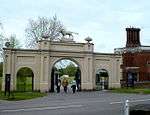 Lion Gate |
| Temple east of Audley End House | Audley End, Saffron Walden | Temple | 1790 | 1 November 1972 | TL5280038100 52°01′13″N 0°13′32″E |
1196116 | 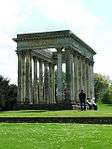 Temple east of Audley End House |
| South Boundary Wall to Park | Audley End, Saffron Walden | Gate | Early 17th century | 28 November 1951 | TL5299237926 52°01′07″N 0°13′41″E |
1204384 | |
| 1–7 Village Street | Audley End, Saffron Walden | House | Later alterations | 28 November 1951 | TL5248537947 52°01′08″N 0°13′15″E |
1196244 | |
| 2–28, Village Street | Audley End, Saffron Walden | House | 17th century | 28 November 1951 | TL5246937942 52°01′08″N 0°13′14″E |
1196245 |  2–28, Village Street |
| Cromwell House | 23, Church St, Saffron Walden | House | 16th century | 28 November 1951 | TL5378838566 52°01′27″N 0°14′24″E |
1196154 | .jpg) Cromwell House |
| Cross Keys Hotel | Saffron Walden | House | 16th century | 28 November 1951 | TL5373338455 52°01′24″N 0°14′21″E |
1196188 | .jpg) Cross Keys Hotel |
| Eight Bells Inn | Saffron Walden | Inn | Early 15th century | 28 November 1951 | TL5355538680 52°01′31″N 0°14′12″E |
1196128 | .jpg) Eight Bells Inn |
| Jubilee House | Saffron Walden | House | c. 1720 | 28 November 1951 | TL5387838426 52°01′22″N 0°14′29″E |
1196204 | |
| Sparrows Charity | Saffron Walden | House | Late 16th century | 28 November 1951 | TL5373638535 52°01′26″N 0°14′21″E |
1205520 | |
| The Priory | Saffron Walden | House | c. 1600 | 28 November 1951 | TL5396438562 52°01′27″N 0°14′33″E |
1297783 | .jpg) The Priory |
| No 21, High Street | Saffron Walden | Apartment | 17th century | 29 August 1969 | 49°46′01″N 7°33′26″W | 1196187 |  No 21, High Street |
| No 53, High St and attached Walls | Saffron Walden | House | Medieval | 28 November 1951 | TL5371938363 52°01′21″N 0°14′20″E |
1206038 |  No 53, High St and attached Walls |
| 5 and 7, Bridge Street | Saffron Walden | House | Late 17th century | 28 November 1951 | TL5356438630 52°01′29″N 0°14′12″E |
1204528 | .jpg) 5 and 7, Bridge Street |
| 24 and 26, Bridge Street | Saffron Walden | House | Mid 16th century | 28 November 1951 | TL5351338719 52°01′32″N 0°14′10″E |
1204567 | .jpg) 24 and 26, Bridge Street |
| 27 and 29, Bridge Street | Saffron Walden | House | 16th century | 28 November 1951 | TL5352038679 52°01′31″N 0°14′10″E |
1297807 | |
| 31, Bridge Street | Saffron Walden | House | Late 16th century | 28 November 1951 | TL5351938688 52°01′31″N 0°14′10″E |
1196126 | |
| 33, Bridge Street | Saffron Walden | House | 17th century | 28 November 1951 | TL5351438683 52°01′31″N 0°14′10″E |
1297768 | |
| 41 and 43 Castle Street | Saffron Walden | House | 19th century | 28 November 1951 | TL5369738692 52°01′31″N 0°14′20″E |
1280720 | .jpg) 41 and 43 Castle Street |
| 45 and 47, Castle Street | Saffron Walden | House | Later alterations | 28 November 1951 | TL5370438693 52°01′31″N 0°14′20″E |
1205408 | 45 and 47, Castle Street |
| 49 and 51, Castle Street | Saffron Walden | House | Later alterations | 28 November 1951 | TL5371138698 52°01′31″N 0°14′20″E |
1205418 | 49 and 51, Castle Street |
| 1, Freshwell Street | Saffron Walden | House | 19th century | 28 November 1951 | TL5355538642 52°01′30″N 0°14′12″E |
1297749 | |
| 11, 13 and 15, Museum Street | Saffron Walden | House | 19th century | 28 November 1951 | TL5377838683 52°01′31″N 0°14′24″E |
1298578 | |
| 17, 19 and 21, King Street | Saffron Walden | House | Early 16th century | 28 November 1951 | TL5379238457 52°01′24″N 0°14′24″E |
1206346 |  17, 19 and 21, King Street |
| 13a and 15, King Street | Saffron Walden | House | c. 1800 | 28 November 1951 | TL5382038473 52°01′24″N 0°14′26″E |
1196208 | |
| 4, Market Hill | Saffron Walden | House | c. 1800 | 28 November 1951 | TL5384938559 52°01′27″N 0°14′27″E |
1206460 | |
| 12 and 14, Market Hill | Saffron Walden | House | Mid 16th century | 28 November 1951 | 49°46′01″N 7°33′26″W | 1196216 | .jpg) 12 and 14, Market Hill |
| Church of St Mary the Virgin | Stansted Mountfitchet | Church | 1120-1124 | 21 February 1967 | TL5210724174 51°53′43″N 0°12′33″E |
1238498 | |
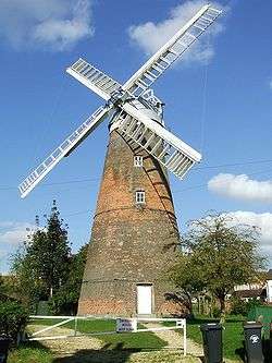
| Stansted Mountfitchet Windmill | Stansted Mountfitchet | Tower Mill | 1787 | 26 November 1951 | TL5097624740 51°54′03″N 0°11′35″E |
1221435 | |
| Parsonage Farmhouse | Stebbing | Kitchen | Late 15th century | 7 February 1952 | TL6626023888 51°53′20″N 0°24′52″E |
1322281 | _(geograph_3603312).jpg) Parsonage Farmhouse |
| Porters Hall | Stebbing | House | Earlier | 7 February 1952 | TL6775723668 51°53′11″N 0°26′10″E |
1322338 |  Porters Hall |
| Stebbing Memorial Club | Stebbing | Public Library | c. 1674 | 20 February 1967 | TL6620924152 51°53′28″N 0°24′50″E |
1168695 | |
| Stebbing Mill | Stebbing | Feed Mill | 18th century | 20 February 1967 | TL6586024063 51°53′26″N 0°24′32″E |
1322337 | |
| Stebbing Park | Stebbing Park, Stebbing | House | Later | 7 May 1952 | TL6574224433 51°53′38″N 0°24′26″E |
1306764 | |
| Tan Farmhouse | Stebbing | Farmhouse | 15th century | 7 February 1952 | TL6599124122 51°53′27″N 0°24′39″E |
1112728 | |
| Chestnuts | Takeley | House | 19th century | 10 September 1981 | TL5574421309 51°52′07″N 0°15′39″E |
1322589 |  Chestnuts |
| Josephes | Takeley | House | Modern | 10 September 1981 | TL5453421290 51°52′08″N 0°14′35″E |
1169005 |  Josephes |
| Moat Cottage | Smith's Green, Takeley | Timber Framed House | Mid 16th century | 20 February 1967 | TL5658521308 51°52′06″N 0°16′22″E |
1112211 | |
| Sheering Hall | Bambers Green, Takeley | House | 18th century | 10 September 1981 | TL5756422889 51°52′56″N 0°17′16″E |
1306827 | |
| Borough Farmhouse | Thaxted | Farmhouse | Late 14th century | 20 February 1967 | TL6070430785 51°57′08″N 0°20′14″E |
1112972 | _(geograph_4758992).jpg) Borough Farmhouse |
| Goddards Farmhouse | Boyton End, Thaxted | Farmhouse | Late 16th century | 7 February 1952 | TL6124032435 51°58′01″N 0°20′44″E |
1165505 | |
| Park Farmhouse | Thaxted | House | 17th century | 7 February 1952 | TL6116630692 51°57′05″N 0°20′38″E |
1112927 | .jpg) Park Farmhouse |
| Prouds Farmhouse | Thaxted | Farmhouse | 14th century | 7 February 1952 | TL6044532663 51°58′09″N 0°20′03″E |
1112152 | |
| Recorder's House | 17, Town St, Thaxted | Jettied House | Mid 15th century | 7 February 1952 | TL6118130911 51°57′12″N 0°20′39″E |
1112902 |  Recorder's House |
| The Manse | 19, Town St, Thaxted | House | Early 19th century | 20 February 1967 | TL6117530914 51°57′12″N 0°20′38″E |
1322261 |  The Manse |
| The Priory | 38, Town St, Thaxted | House | 18th century | 20 February 1967 | TL6114630987 51°57′14″N 0°20′37″E |
1112944 | |
| Town House | 25, Town St, Thaxted | House | late 15th century or early 16th century | 20 February 1967 | TL6114330934 51°57′13″N 0°20′37″E |
1112904 | |
| John Webb's Windmill | Thaxted | Tower Mill | 1804 | 7 February 1952 | TL6096630818 51°57′09″N 0°20′27″E |
1112153 | 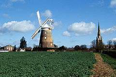 John Webb's Windmill |
| 16 Watling Street | Thaxted | House | 18th century | 20 February 1967 | TL6110031049 51°57′17″N 0°20′35″E |
1166190 | 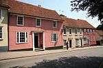 16 Watling Street |
| 1, Stoney Lane | Thaxted | House | 14th century with 18th century alterations | 20 February 1967 | TL6113330956 51°57′14″N 0°20′36″E |
1112933 | |
| Tilty Mill | Tilty | Watermill | Early 18th century | 10 September 1981 | TL5994426734 51°54′58″N 0°19′27″E |
1112221 | 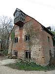 Tilty Mill |
| Church of St Peter | Ugley | Church | 13th century | 21 February 1967 | TL5196128755 51°56′12″N 0°12′33″E |
1275055 | 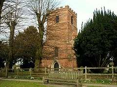 Church of St Peter |
| Orford House | Ugley | House | c. 1700 | 21 February 1967 | TL5147627081 51°55′18″N 0°12′05″E |
1221630 | |
| Dovecote at Hall Farm, Lofts Hall | Lofts Hall, Wenden Lofts | Dovecote | 16th century | 21 February 1967 | TL4644438721 52°01′39″N 0°07′59″E |
1238148 | |
| Barn to North of Colville Hall | White Roothing | Barn | 15th century Or early 16th century | 13 June 1983 | TL5535613456 51°47′53″N 0°15′06″E |
1308419 | |
| Byre to West of Colville Hall | White Roothing | Cow House | LATE 14th century or Early 15th century | 13 June 1983 | TL5533013416 51°47′52″N 0°15′04″E |
1112004 | |
| Cammas Hall | White Roothing | Hall | Late 16th century | 7 February 1952 | TL5653615302 51°48′52″N 0°16′10″E |
1111989 | |
| Church of St Martin | White Roothing | Church | 11th century | 20 February 1967 | TL5617513351 51°47′49″N 0°15′48″E |
1322680 | .jpg) Church of St Martin |
| Colville Hall | White Roothing | House | Later | 7 February 1952 | TL5536713420 51°47′52″N 0°15′06″E |
1112003 | |
| Gateway at Colville Hall | White Roothing | Gate | Early 16th century | 7 February 1952 | TL5541313373 51°47′51″N 0°15′08″E |
1147664 | |
| Granary to North West of Colville Hall | White Roothing | Granary | 15th century | 13 June 1983 | TL5536813447 51°47′53″N 0°15′06″E |
1112005 | |
| Lower Barn North East of Colville Hall | White Roothing | Barn | 1630 | 13 June 1983 | TL5534113479 51°47′54″N 0°15′05″E |
1322692 | |
| Lucas Farm House | White Roothing | Farmhouse | Early and mid 16th century | 13 June 1983 | TL5765813787 51°48′02″N 0°17′06″E |
1322653 | 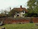 Lucas Farm House |
| Brick House | Wicken Bonhunt | House | c. 1600 | 26 November 1951 | TL4973233102 51°58′34″N 0°10′43″E |
1238316 | |
| Church of St Margaret | Wicken Bonhunt | Church | 13th century | 21 February 1967 | TL4988733346 51°58′42″N 0°10′51″E |
1238314 | 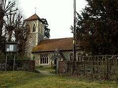 Church of St Margaret |
| Church of St Mary the Virgin | Widdington | Church | 12th century | 21 February 1967 | TL5397231779 51°57′47″N 0°14′23″E |
1238372 | 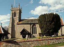 Church of St Mary the Virgin |
| Thistley Hall | Widdington | House | c. 1670 | 26 November 1951 | TL5563731090 51°57′23″N 0°15′49″E |
1112403 | .jpg) Thistley Hall |
| Broadoaks Farmhouse | Wimbish | Farmhouse | 1980 | 26 November 1951 | TL5899133570 51°58′40″N 0°18′49″E |
1238676 | .jpg) Broadoaks Farmhouse |
| Operations Block, Carver Barracks (former RAF Debden) | Caversfield, Wimbish | Barracks | 1938 | 1 December 2005 | TL5686234523 51°59′13″N 0°16′59″E |
1392874 | |
Notes
- The date given is the date used by Historic England as significant for the initial building or that of an important part in the structure's description.
- Sometimes known as OSGB36, the grid reference is based on the British national grid reference system used by the Ordnance Survey.
- The "List Entry Number" is a unique number assigned to each listed building and scheduled monument by Historic England.
gollark: I also used `warp` in Rust once... the type errors were *horrible*. They were several lines filled with dense crazy generics.
gollark: Kind of? I mean, I find those easier to debug, possibly just due to greater exposure.
gollark: Anyway, I remember working on this, and spending most of the time on it just debugging unintuitive type errors.
gollark: I think it complained when I tried that that I should move them back to files.
gollark: Yes, I'm aware it's probably horrible and not idiomatic.
External links
![]()
This article is issued from Wikipedia. The text is licensed under Creative Commons - Attribution - Sharealike. Additional terms may apply for the media files.