Gibson County, Indiana
Gibson County is a county in the southwestern part of the U.S. state of Indiana. As of 2010, the population was 33,503.[1] The county seat is Princeton.[2]
Gibson County | |
|---|---|
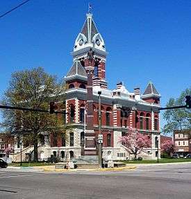 The southeastern face of the current Gibson County Courthouse in Princeton, built in 1884 and the Civil War monument built in 1912. | |
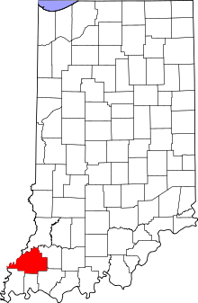 Location within the U.S. state of Indiana | |
 Indiana's location within the U.S. | |
| Coordinates: 38°19′N 87°35′W | |
| Country | |
| State | |
| Founded | April 1, 1813 From Knox and Harrison Counties |
| Named for | John Gibson |
| Seat | Princeton |
| Largest city | Princeton |
| Area | |
| • Total | 499.16 sq mi (1,292.8 km2) |
| • Land | 487.49 sq mi (1,262.6 km2) |
| • Water | 11.68 sq mi (30.3 km2) 2.34%% |
| Population | |
| • Estimate (2018) | 33,452 |
| • Density | 69/sq mi (26.46/km2) |
| Time zone | UTC−6 (Central) |
| • Summer (DST) | UTC−5 (CDT) |
| Congressional district | 8th |
| Website | Gibson County, Indiana |
| |
Gibson County is included in the Evansville, Indiana–Kentucky Metropolitan Statistical Area.
History
From 1790 to 1813, this area was part of Knox County, Indiana. The first white settler of what became Gibson County was John Severns, a native of Wales who had come with his parents to North America several years before the Revolutionary War. He settled in Gibson County in 1789–90 on the south bank of the Patoka River at a place now known as Severns Bridge. Another early Gibson County settler was William Hargrove, who came from Kentucky by pack mule in 1803; Captain Hargrove commanded a company of militia from Gibson County at the Battle of Tippecanoe in 1811.

The Rev. Joseph Milburn and his son Robert also arrived in 1803. They settled near Princeton, between the Patoka and White Rivers. The Milburns were from the area of Washington County, Kentucky. Rev. Milburn, a Baptist, established the first church; Robert established the first distillery in Indiana.
In 1805, Jacob Warrick arrived, along with his father-in-law, Thomas Montgomery. They burned out the last Native American village in 1807, chasing the inhabitants into the Illinois Territory. Captain Warrick was killed at the Battle of Tippecanoe in 1811.
Gibson and Warrick Counties were organized in 1813 out of Knox County. Gibson County was named for John Gibson, an officer in the French and Indian War and the Revolutionary War.[3][4] Gibson was Secretary of the Indiana Territory, serving as acting Governor on two occasions. The two counties of Gibson County and Warrick County, separated by Rector's Base Line, were formed March 9, 1813. Gibson County was organized on April 1, 1813 while Warrick County was organized on April 30, meaning that both territories fell under Gibson County for that nearly two month period. Gibson County occupied everything from the Wabash River and from the White River's extension to the Paoli Base Line down the 2d Principal Meridian to the Rector's Base Line. The area south of this line became Warrick County, which covered the area from the 2d Principal Meridian west to the Wabash River and down the Wabash River and with meanders up the Ohio River back to the 2d Principal Meridian (which had separated Knox County from Harrison County, Indiana Territory). Orange County, Spencer County, Pike County, Dubois County, and Crawford County all came from the roughly 2,000-square-mile (5,200 km2) area occupied by the original Gibson County, as well as small portions of Lawrence County, Perry County, Posey County, the current Warrick County, and Vanderburgh County.
When the county was organized, Patoka was intended to be the county seat. However, Patoka's low-lying location along the Patoka River gave rise to a malaria epidemic; to avoid this, the commissioners chose to establish a new town, eventually known as Princeton, on higher ground approximately 4 miles (6 km) south. However, although Princeton contends it was the only county seat, some contend county records indicate Owensville was a temporary county seat since Princeton was not laid out until late 1814, at least a year after Gibson County's organization.
Abolitionists
Although Indiana was technically a "free state," those assisting runaway slaves were guilty of breaking the law and could be prosecuted and jailed. Despite the legal threats, the Abolitionist movement was strong in Gibson County where many were active in the Underground Railroad, some openly known as Abolitionists such as David Stormont and his wife who maintained a station at their home three miles northwest of Princeton, along with John Carithers who aided runaway slaves at his home east of Princeton,[5] Sarah Merrick, Princeton, was jailed in Gibson County for helping a runaway slave and her children from nearby Henderson, Kentucky, where slavery was legal, escape to free territory after she was unable or unwilling to pay her $500 bail. One individual, a Presbyterian minister, the Reverend Thomas B. McCormick, was so well known as an Abolitionist that he fled to Canada after the Kentucky governor requested his extradition.[6] Joseph Hartin, Princeton, politically identified as an Abolitionist.[5] James Washington Cockrum, originally from North Carolina, maintained a station at his home in Oakland City, first hiding runaways in a root cellar of their log cabin. His son William, who later authored History of the Underground railroad as it was conducted by the Anti-slavery league; including many thrilling encounters between those aiding the slaves to escape and those trying to recapture them, aided him in the family effort to free runaways. The family home in Oakland City, known as Cockrum Hall, is located on the grounds of present-day Oakland City University and is recognized as a prominent station on the Underground Railroad.[7]
Geography
Gibson County is the northern third of the Evansville, Indiana–Kentucky Metropolitan Statistical Area. Nearly 90% of the county exists within the Ohio River Valley American Viticultural Area along with all of neighboring Posey, Vanderburgh and Warrick counties and a portion of Pike County.[8] Despite being close to Evansville and experiencing a large growth of population in the central areas, Gibson County still remains a largely rural county with half of the ten townships having populations less than 2,000. Less than 7 percent of the county's 500 square miles (1,300 km2) lies within incorporated settlements, or 10 percent if subdivisions are included.
The western part of the county consists largely of spread-out flood-prone farms with spotty marshes along the Wabash and White Rivers. There are rolling hills around Owensville, and large forest and marshland tracts lie near the Gibson Generating Station and the three river settlements of Crawleyville, East Mount Carmel, and Skelton. The northern part is near the White River and is more given to hills and forest. The eastern part contains many hills and is also dotted with strip pits and active coal mines. The southern part is more given to valley and marshland, drained by the Pigeon Creek which flows south through Evansville.
Even without Interstate 69, the county is within a day's drive of Chicago, Cincinnati, Chattanooga, Columbus, Indianapolis, Louisville, Memphis, Nashville, Springfield, St. Louis, even South Bend, and Fort Wayne despite the lack of freeway connection. There are two major intersections in the southern extremes of the county. One is the intersection of Interstate 64 and US 41. The other is between Interstate 64 and Interstate 69, which will eventually link the county and Evansville to Indianapolis and Memphis and make a day trip to even Detroit possible.
The western half of the Patoka River National Wildlife Refuge and Management Area lies within Gibson County.
According to the 2010 census, the county has a total area of 499.16 square miles (1,292.8 km2), of which 487.49 square miles (1,262.6 km2) (or 97.66%) is land and 11.68 square miles (30.3 km2) (or 2.34%) is water.[9]
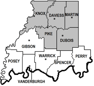
Adjacent counties
- White County, Illinois (west of panhandle or "tail" of Gibson County. This boundary is now along Bonpas Creek instead of the Wabash River.)
- Wabash County, Illinois (northwest & west)
- Knox County (north & northwest)
- Pike County (east & northeast)
- Warrick County (southeast & east)
- Vanderburgh County (south)
- Posey County (southwest & west)
Cities
|
|
Towns
|
|
|

Unincorporated communities
|
|
|
* Baldwin Heights and Northbrook Hills are within the city limits of Princeton.
Townships
Gibson County consists of ten townships:
Two townships, Wabash and Washington, contain no incorporated towns.
Climate and weather
| Princeton, Indiana | ||||||||||||||||||||||||||||||||||||||||||||||||||||||||||||
|---|---|---|---|---|---|---|---|---|---|---|---|---|---|---|---|---|---|---|---|---|---|---|---|---|---|---|---|---|---|---|---|---|---|---|---|---|---|---|---|---|---|---|---|---|---|---|---|---|---|---|---|---|---|---|---|---|---|---|---|---|
| Climate chart (explanation) | ||||||||||||||||||||||||||||||||||||||||||||||||||||||||||||
| ||||||||||||||||||||||||||||||||||||||||||||||||||||||||||||
| ||||||||||||||||||||||||||||||||||||||||||||||||||||||||||||
In recent years, average temperatures in Princeton have ranged from a low of 21 °F (−6 °C) in January to a high of 88 °F (31 °C) in July, although a record low of −19 °F (−28 °C) was recorded in January 1985 and a record high of 113 °F (45 °C) was recorded in July 1936. Average monthly precipitation ranged from 2.90 inches (74 mm) in January to 5.11 inches (130 mm) in May.[10]
Demographics
| Historical population | |||
|---|---|---|---|
| Census | Pop. | %± | |
| 1830 | 6,192 | — | |
| 1840 | 6,280 | 1.4% | |
| 1850 | 6,403 | 2.0% | |
| 1860 | 7,855 | 22.7% | |
| 1870 | 7,939 | 1.1% | |
| 1880 | 8,282 | 4.3% | |
| 1890 | 11,156 | 34.7% | |
| 1900 | 11,227 | 0.6% | |
| 1910 | 13,661 | 21.7% | |
| 1920 | 18,061 | 32.2% | |
| 1930 | 19,666 | 8.9% | |
| 1940 | 23,926 | 21.7% | |
| 1950 | 27,777 | 16.1% | |
| 1960 | 28,567 | 2.8% | |
| 1970 | 28,799 | 0.8% | |
| 1980 | 29,233 | 1.5% | |
| 1990 | 30,159 | 3.2% | |
| 2000 | 32,580 | 8.0% | |
| 2010 | 33,503 | 2.8% | |
| Est. 2018 | 33,452 | [11] | −0.2% |
| U.S. Decennial Census[12] 1790–1960[13] 1900–1990[14] 1990–2000[15] 2010–2013[1] | |||
As of the 2010 United States Census, there were 33,503 people, 13,255 households, and 9,168 families residing in the county.[16] The population density was 68.7 inhabitants per square mile (26.5/km2). There were 14,645 housing units at an average density of 30.0 per square mile (11.6/km2).[9] The racial makeup of the county was 95.5% white, 1.8% black or African American, 0.5% Asian, 0.2% American Indian, 0.5% from other races, and 1.6% from two or more races. Those of Hispanic or Latino origin made up 1.3% of the population.[16] In terms of ancestry, 28.3% were German, 24.3% were American, 13.1% were Irish, and 11.7% were English.[17]
Of the 13,255 households, 32.3% had children under the age of 18 living with them, 55.0% were married couples living together, 9.7% had a female householder with no husband present, 30.8% were non-families, and 26.5% of all households were made up of individuals. The average household size was 2.47 and the average family size was 2.98. The median age was 39.9 years.[16]
The median income for a household in the county was $47,697 and the median income for a family was $61,652. Males had a median income of $43,271 versus $28,424 for females. The per capita income for the county was $22,542. About 7.6% of families and 12.2% of the population were below the poverty line, including 16.1% of those under age 18 and 9.8% of those age 65 or over.[18]
Government and politics
| Gibson County Sheriff's Department | |
|---|---|
| Jurisdictional structure | |
| Operations jurisdiction | Gibson, Indiana, United States |
| Size | 499 sq mi |
| Legal jurisdiction | As per operations jurisdiction |
| General nature | |
| Operational structure | |
| Agency executive |
|
| Facilities | |
| Stations | 1 |
| Jails | 1 |
| Cars | 24 |
The county government is a constitutional body granted specific powers by the Constitution of Indiana, and by the Indiana Code.
The county council is the fiscal branch of the county government and controls all the spending and revenue collection in the county. Representatives are elected from county districts. The council members serve four-year terms. They are responsible for setting salaries, the annual budget, and special spending. The council also has limited authority to impose local taxes, including income and property taxes (which are subject to state-level approval), excise taxes, and service taxes. The Council Members are, Jay Riley, Derek McGraw, Bill McConnell, Mike Stilwell, Dan Beard, Craig Pflug, and Jeremy Overton.[19][20]
The Board of Commissioners is the legislative and executive body of the county government. The commissioners are elected county-wide, in staggered four-year terms. One of the commissioners—typically the most senior—serves as president. The commissioners are charged with executing the acts legislated by the council, collecting revenue, and managing the day-to-day functions of the county government. The Commissioners are Steve Bottoms, Gerald Bledsoe, and Mary Key.[19][20]
The county maintains two court systems, Circuit Court, with Judge Jeff Meade, presiding and Superior Court, with Judge Robert Krieg, presiding. The judges on the court are elected to a term of six years and must be a member of the Indiana Bar Association. In some cases, court decisions can be appealed to the state level circuit court.[20]
The county has several other elected offices, including Sheriff, Timothy Bottoms; Coroner, Misty Hoke; Auditor, Sherri Smith; Treasurer, Mary O'Neal; Recorder, Tonya Thompson; Surveyor, Scott Martin; Assessor, Kim Minkler; and Circuit Court Clerk, Jim Morrow. Each of these elected officers serves a term of four years and oversees a different part of county government. Members elected to county government positions are required to declare party affiliations and to be residents of the county.[20]
Timothy Bottoms was elected sheriff of Gibson County in 2014, becoming the first Republican sheriff since 1982.
Gibson County is part of Indiana's 8th congressional district; Indiana Senate districts 48 and 49;[21] and Indiana House of Representatives districts 64, 75 and 76.[22]
| Year | Republican | Democratic | Third parties |
|---|---|---|---|
| 2016 | 71.6% 11,081 | 24.0% 3,721 | 4.4% 682 |
| 2012 | 64.5% 9,487 | 33.5% 4,928 | 2.1% 306 |
| 2008 | 55.7% 8,449 | 42.6% 6,455 | 1.7% 260 |
| 2004 | 62.5% 9,133 | 36.8% 5,378 | 0.7% 103 |
| 2000 | 56.2% 7,734 | 42.1% 5,802 | 1.7% 236 |
| 1996 | 39.9% 5,392 | 48.0% 6,488 | 12.2% 1,648 |
| 1992 | 35.0% 5,172 | 46.7% 6,909 | 18.4% 2,719 |
| 1988 | 51.8% 7,610 | 47.9% 7,031 | 0.3% 43 |
| 1984 | 54.6% 8,618 | 44.9% 7,082 | 0.5% 77 |
| 1980 | 50.3% 7,643 | 45.0% 6,834 | 4.7% 712 |
| 1976 | 45.6% 7,105 | 54.0% 8,430 | 0.4% 64 |
| 1972 | 61.5% 9,115 | 38.0% 5,633 | 0.5% 71 |
| 1968 | 47.9% 7,645 | 42.5% 6,777 | 9.6% 1,535 |
| 1964 | 35.6% 5,865 | 63.8% 10,507 | 0.5% 86 |
| 1960 | 53.9% 8,838 | 45.6% 7,479 | 0.5% 82 |
| 1956 | 55.6% 9,256 | 43.9% 7,318 | 0.5% 79 |
| 1952 | 54.0% 9,171 | 44.8% 7,617 | 1.2% 198 |
| 1948 | 47.3% 7,431 | 50.9% 7,988 | 1.9% 290 |
| 1944 | 50.9% 7,895 | 48.1% 7,462 | 1.1% 168 |
| 1940 | 48.3% 8,326 | 50.6% 8,709 | 1.1% 188 |
| 1936 | 42.4% 7,078 | 56.2% 9,392 | 1.4% 240 |
| 1932 | 39.3% 6,237 | 57.8% 9,162 | 2.9% 464 |
| 1928 | 57.1% 8,137 | 41.3% 5,882 | 1.7% 240 |
| 1924 | 49.6% 7,100 | 43.0% 6,149 | 7.4% 1,059 |
| 1920 | 51.3% 7,498 | 43.7% 6,384 | 5.0% 728 |
| 1916 | 45.8% 3,576 | 48.3% 3,765 | 5.9% 460 |
| 1912 | 31.0% 2,266 | 44.4% 3,250 | 24.6% 1,798 |
| 1908 | 48.4% 3,753 | 47.2% 3,656 | 4.4% 338 |
| 1904 | 51.3% 3,871 | 42.7% 3,221 | 6.1% 458 |
| 1900 | 49.1% 3,648 | 47.3% 3,509 | 3.6% 267 |
| 1896 | 48.4% 3,471 | 50.5% 3,622 | 1.1% 82 |
| 1892 | 45.3% 2,738 | 40.7% 2,460 | 13.9% 841 |
| 1888 | 49.7% 2,953 | 45.8% 2,721 | 4.4% 263 |
Overall Gibson County has been a Republican stronghold in national politics. In contrast, Democrats tend to be strong on county-level politics. Princeton accounts for the majority of consistent Democratic support within the county, whereas outside of Princeton, particularly South Gibson is where the consistent Republican support is found.
Recent disasters
2004 snowstorm
In the holiday season of 2004, a crippling snowstorm dumped over twice the normal annual snowfall in three days. Accumulations averaged 20 inches in Gibson County, with snow drifts reaching over 4 feet (1.2 m) in spots and some spots of Gibson County receiving as much as 32 inches (0.81 m).[24] Interstate 64 was closed down. The Indiana National Guard was dispatched and local farmers were recruited to assist in emergency services for stranded motorists.
2005 flood
The White River at Hazleton got as high as 31 feet (9.4 m), almost high enough to overtake US 41,[25] while the Wabash River at Mount Carmel, Illinois rose to 33.95 feet (10.35 m).[26] Extreme flooding occurred throughout the county and hundreds of local high school students from many counties assisted the Indiana National Guard in shoring up levees and sandbagging towns. Hazleton was evacuated because its levee was showing signs of fatigue. All of the levees held. By the end of January 2005, the rivers had receded enough to allow people to return to their homes. Over 100 homes were lost in the flood, which was considered the second-worst flood in the area's history (after the Great Flood of 1913).[26]
2008 earthquake
With a moment magnitude of 5.2 and a maximum Mercalli intensity of VII, the 2008 Illinois earthquake was one of the largest instrumentally recorded earthquakes in Illinois. It occurred at 4:37:00 a.m. CDT (9:37:00 UTC) on April 18 within the Wabash Valley Seismic Zone at a depth of 11.6 km. It was centered near West Salem, Illinois and Mount Carmel, Illinois, specifically at 38.45° N, 87.89° W.
2008 flood
A major flood occurred in June 2008. It was caused by intense rainfall and the source of the flood was entirely upstream.[27] Both the Wabash and White Rivers were severely flooded and nearly all of Gibson County's levees held the flood back, while many levees upstream were failing.[28]
2017 tornado
On the evening of February 28, 2017, a powerful and extremely violent EF3 tornado struck areas of southern Illinois and Southwest Indiana, the tornado began near Crossville, IL where it caused one death, the tornado then continued northeast, crossing the Wabash River into Posey County, IN where it caused mainly tree and relatively minor structure damage, the tornado then continued its track east-northeast into southern Gibson County where the most intense damage occurred just north of the Posey County line, 2 people received minor injuries there, the tornado continued, causing damage along the way, until ending near Oakland City, IN after tracking 44 miles.[29][30]
Transportation
County roads
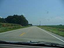
Gibson County has over 1,700 miles (2,700 km) of county roads, one of the largest amounts of county-maintained roads outside of an urban county. Like most Indiana counties, Gibson County uses the Indiana county road system to identify its roads. U.S. Route 41 (a north-south road) and State Road 64 (an east-west road) are near the meridian and division lines for the county, respectively.
Major highways

Interstate 69
A section of Interstate 69's construction groundbreaking occurred on July 16, 2008, at the Centre in Evansville. This project has its controversy, highlighted by a group of protesters in attendance.
A portion of the first segment opened in late September 2009. [31][32] The entire stretch of highway in Gibson County was open to traffic on November 15, 2012.
Railroads
Three railroad lines pass through the county. CSX Transportation operates a north-south line, and Norfolk Southern Railway operates an east-west line; they intersect in Princeton. A north-south Indiana Southern Railroad line intersects the Norfolk Southern line at Oakland City.[33]
Sports
Gibson County's association with baseball is far-reaching with known Major League Baseball players and announcers such as Gary Denbo and Dave Niehaus, and most notably MLB hall of famer Edd Roush and MLB legend Gil Hodges, the namesake of Gil Hodges Field, a little league field in Princeton.
Gibson County has recently made its mark on the High School scene with two softball titles by Gibson Southern and a double overtime Boys Basketball State Title by Princeton in 2009, completing a 29–0 season as well as PCHS now holding the All-time points record with Jackie Young as of 2016 and a 2015 Girls Basketball State Title. In addition there are three State Runner-Up Titles. All of these titles have been acquired since Gibson Southern's Softball Runner-Up Title in 2001.
Education

East Gibson in Green
North Gibson in Red
South Gibson in Maroon
Gibson County's three municipal school districts
East Gibson School Corporation – Oakland City:
- Waldo J. Wood Memorial Jr/Sr High School – Oakland City
(Trojans) - Oakland City Elementary School – Oakland City
(Acorns) - Francisco Elementary School – Francisco
(Owls) - Barton Township School – Mackey
(Aces)
North Gibson School Corporation – Princeton:
- Princeton Community High School – Princeton
(Tigers) - Princeton Community Middle School – Princeton
(Tigers) - Brumfield Elementary School (formerly the "Early Learning Center") – Princeton
(Tiger Cubs)
South Gibson School Corporation – Fort Branch:

- Gibson Southern High School – Fort Branch
(Titans) - Fort Branch Community School (K-8) – Fort Branch
(Twigs) - Haubstadt Community School (K-8) – Haubstadt
(Elites) - Owensville Community School (K-8) – Owensville
(Kickapoos)
Private education
Gibson County's Private Education consists of four Catholic Schools run by the Roman Catholic Diocese of Evansville and one non-Catholic Christian school. Holy Cross, St. James, and Bethel field basketball teams. Enrollment and Grades are in the 1st parentheses.[34] Mascot (I/A) is in 2nd parentheses.
- Bethel Christian School – Princeton (K3-8:112) (Crusaders)
- Holy Cross Catholic School – Fort Branch (K-5:111) (Crusaders)
- St. James Catholic School – St. James/Haubstadt (K-8:185) (Cougars)
- St. Joseph Catholic School – Princeton (K-5:185)
- St.s Peter & Paul Catholic School – Haubstadt (K-5:200)
Higher education
- Oakland City University – Oakland City, Private university
- Vincennes University Workforce Training Center – Princeton Branch – On southwest corner of Gibson County Courthouse
- Ivy Tech Campus – 2 miles (3.2 km) south of Princeton, soon to be within city limits in upcoming annexation.
- Vincennes University Center for Advanced Manufacturing – located near Fort Branch Community School at U.S. 41 and Coal Mine Road (CR 800 South). Groundbreaking was on October 23, 2009 with Construction starting on November 3, 2009.[35] Many workforce programs are offered at the Gibson County Center, including certified miner safety training and heavy equipment operator training. In February 2016, in cooperation with North American Crane Certifications (NACC), this facility became an official training and testing site for Crane Institute Certification (CIC)[36]
Businesses
Industry
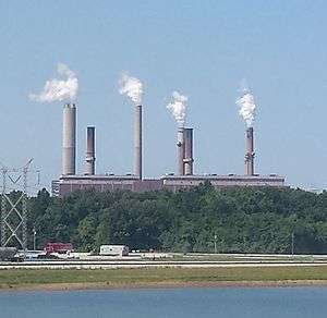
- Gibson Generating Station (Coal), Owensville (across IN-64 from East Mount Carmel and across the Wabash River from Mount Carmel, Illinois, 7 miles northwest of Owensville and 10 miles west of Princeton).
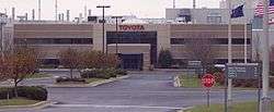
- Toyota Motor Manufacturing Indiana (TMMI), Princeton (located almost exactly halfway between Princeton and Fort Branch and largely in Union Township but addressed to Princeton.)
Produces the Toyota Highlander, Toyota Sienna, and the Toyota Sequoia. - Hansen Corporation, Princeton (located on the south side)
- Millennium Steel, Princeton (Located Immediately north of Toyota). Visited by President Barack Obama on October 3, 2014.
- Vuteq, Princeton (Located at north east corner of Toyota Plant Complex).
- Gibson County Quality Assurance, Princeton (Located in Gibson County Warehousing Complex— 1 mile (2 km) north of the Toyota Plant). Also has a warehouse complex southeast of the Toyota Plant.
- Toyota Tsusho, Princeton (Located in Gibson County Warehousing complex— 1 mile (2 km) north of Toyota Plant).
- Toyota Boshoku Indiana (TBIN), formerly TISA (Total Interior Systems of America), Princeton (Located at north end of the Industrial Park on Gach Road).
- Peabody Energy, Francisco Mine (Formerly Black Beauty Coal Co.) (Located north of Francisco, IN).
- Gibson County Coal, Operates a large mine northwest of Princeton, a service mine 7 miles west of Princeton, and a mine north of Owensville.
- Norfolk Southern Railway
- CSX Transportation
Proposed Industry or Industry under construction
Broadcast media
- TV 06 W06BD – Operated by Princeton Community High School.
- FM 98.1 WRAY-FM – Princeton – Country Music
- FM 101.5 WBGW-FM – Fort Branch – Religious Music/Talk
- AM 1250 WRAY – Princeton – News/Talk
Newspapers
- Gibson County Today – Princeton
- Princeton Daily Clarion – Princeton
- Oakland City Journal – Oakland City
- South Gibson Star-Times – Owensville, Fort Branch, and Haubstadt
- South Gibson Bulletin – Owensville, Fort Branch, and Haubstadt
Recreation
- Gibson County Fairgrounds – Princeton – site of Indiana's oldest county fair, started in 1852.[37]
- Azalea Path Arboretum and Botanical Gardens (Located South of Mt Olympus on the Gibson/Pike County Line)
- Oakland City New Lake – Oakland City
- Lafayette Park – Princeton
- Gil Hodges Field – Princeton
- Camp Carson YMCA Campground – Princeton
- Haubstadt Old School Park and Old Gym – Haubstadt
- Tri-State Speedway – Haubstadt
- Weather Rock Campground – Warrenton
- Montgomery Park – Owensville
- REH Center (Old Owensville Gym) – Owensville
- Gibson Lake – Owensville
- Marlette Park – Fort Branch
- Old Gym – Fort Branch
- City Park of Fort Branch
- Gibson Southern High School Grounds – Fort Branch
- Patoka River National Wildlife Refuge and Management Area – Francisco and Oakland City
- Hemmer Woods State Nature Preserve – Southeast of Mackey
See also
References
- Specific
- "Gibson County QuickFacts". United States Census Bureau. Archived from the original on 2011-06-07. Retrieved 2011-09-17.
- "Find a County". National Association of Counties. Archived from the original on 2011-05-31. Retrieved 2011-06-07.
- Gannett, Henry (1905). The Origin of Certain Place Names in the United States. U.S. Government Printing Office. p. 137.
- De Witt Clinton Goodrich & Charles Richard Tuttle (1875). An Illustrated History of the State of Indiana. Indiana: R. S. Peale & co. p. 558.
- Stormont, Gil R. (1914). History of Gibson County, Indiana : her people, industries and institutions, with biographical sketches of representative citizens and genealogical records of many of the old families. Indianapolis, IN: B. F. BOWEN & CO., Inc. pp. 651–652.
- "IHB: The Underground Railroad". www.in.gov. Retrieved 2017-07-11.
- Snodgrass, Mary Ellen (2008). The Underground Railroad: An Encyclopedia of People, Places, and Operations. New York: Routledge. p. 124.
- Edocket.access.gpo.gov
- "Population, Housing Units, Area, and Density: 2010 – County". United States Census Bureau. Archived from the original on 2020-02-10. Retrieved 2015-07-10.
- "Monthly Averages for Princeton, Indiana". The Weather Channel. Retrieved 2011-01-27.
- "Population and Housing Unit Estimates". Retrieved July 26, 2019.
- "U.S. Decennial Census". United States Census Bureau. Retrieved July 10, 2014.
- "Historical Census Browser". University of Virginia Library. Retrieved July 10, 2014.
- "Population of Counties by Decennial Census: 1900 to 1990". United States Census Bureau. Retrieved July 10, 2014.
- "Census 2000 PHC-T-4. Ranking Tables for Counties: 1990 and 2000" (PDF). United States Census Bureau. Retrieved July 10, 2014.
- "DP-1 Profile of General Population and Housing Characteristics: 2010 Demographic Profile Data". United States Census Bureau. Archived from the original on 2020-02-13. Retrieved 2015-07-10.
- "DP02 SELECTED SOCIAL CHARACTERISTICS IN THE UNITED STATES – 2006–2010 American Community Survey 5-Year Estimates". United States Census Bureau. Archived from the original on 2020-02-14. Retrieved 2015-07-10.
- "DP03 SELECTED ECONOMIC CHARACTERISTICS – 2006–2010 American Community Survey 5-Year Estimates". United States Census Bureau. Archived from the original on 2020-02-14. Retrieved 2015-07-10.
- Indiana Code. "Title 36, Article 2, Section 3". IN.gov. Retrieved 2008-09-16.
- Indiana Code. "Title 2, Article 10, Section 2" (PDF). IN.gov. Retrieved 2008-09-16.
- "Indiana Senate Districts". State of Indiana. Retrieved 2011-01-23.
- "Indiana House Districts". State of Indiana. Retrieved 2011-01-23.
- Leip, David. "Dave Leip's Atlas of U.S. Presidential Elections". uselectionatlas.org. Retrieved 2018-05-16.
- NWS Paducah, KY
- Advanced Hydrologic Prediction Service: Indianapolis: White River at Hazleton
- Advanced Hydrologic Prediction Service: Indianapolis: Wabash River at Mount Carmel
- SRH.noaa.gov, Precipitation Analysis Pages.
- Tristate-media.com
- NWS Paducah [@NWSPaducah] (1 March 2017). "Part 2 Survey team work continues...a preliminary rating of EF-3 is expected with the storm damage near Poseyville Indiana" (Tweet) – via Twitter.
- http://www.tristatehomepage.com/news/local-news/damage-reported-in-posey-gibson-white-counties/664402595
- Invitation-only groundbreaking set for I-69 segment : Local News : Evansville Courier Press
- Long-awaited I-69 begins : Local News : Evansville Courier Press
- "Indiana Railroad Map" (PDF). Indiana Department of Transportation. 2006. Archived from the original (PDF) on 2007-09-26. Retrieved 2007-10-14.
- "Gibson County Private Schools". Archived from the original on 2016-03-06. Retrieved 2007-12-25.
- Che.state.in.us Archived July 20, 2011, at the Wayback Machine
- "Archived copy". Archived from the original on 2015-09-30. Retrieved 2015-10-13.CS1 maint: archived copy as title (link)
- The first Indiana State Fair Queen Pageant was held in 1958 when Carol Parks of Montgomery County was crowned
- General
- Stormont, Gil R. (1914). History of Gibson County, Indiana.
External links
| Wikimedia Commons has media related to Gibson County, Indiana. |
Places adjacent to Gibson County, Indiana | ||||||||||
|---|---|---|---|---|---|---|---|---|---|---|
| ||||||||||
Articles Relating to Gibson County | |||||||||||||||||||||||||||||||||||||||||||||||||||
|---|---|---|---|---|---|---|---|---|---|---|---|---|---|---|---|---|---|---|---|---|---|---|---|---|---|---|---|---|---|---|---|---|---|---|---|---|---|---|---|---|---|---|---|---|---|---|---|---|---|---|---|
| |||||||||||||||||||||||||||||||||||||||||||||||||||


| Authority control |
|
|---|