Indiana State Road 357
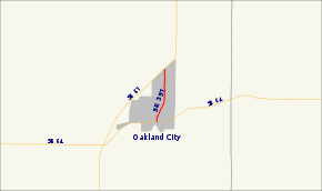
State Road 357 in the U.S. state of Indiana is a very short north–south state highway in Gibson County, entirely within the city of Oakland City.
| ||||
|---|---|---|---|---|
 | ||||
| Route information | ||||
| Maintained by INDOT | ||||
| Length | 1.238 mi[1] (1.992 km) | |||
| Major junctions | ||||
| South end | ||||
| North end | ||||
| Location | ||||
| Counties | Gibson | |||
| Highway system | ||||
| ||||
Route description
State Road 357 starts at State Road 64, which is also Morton Street, on the south side of town. It runs north for about 200 feet, then veers to the north-northeast and runs parallel with the railroad track about 100 feet to the east. Upon reaching Mill Street, the road veers back to the north and proceeds to its northern terminus at State Road 57 at the north edge of town. It is concurrent with Main Street over its entire length.
Major intersections
The entire route is in Oakland City, Gibson County.
| mi[1] | km | Destinations | Notes | ||
|---|---|---|---|---|---|
| 0.000 | 0.000 | Southern terminus of SR 357 | |||
| 1.238 | 1.992 | Northern terminus of SR 357 | |||
| 1.000 mi = 1.609 km; 1.000 km = 0.621 mi | |||||
gollark: ALL protocols are to support reasonable confidentiality.
gollark: Maybe, but it can have POST bodies.
gollark: - gpg is isomorphic to cryoapioform - it is already too late, as I just interfaced this with a JS engine and some HTML layouting stuff and am accessing my email through this; for now, I am using an SSH tunnel, but this is uncool, so security *is* required - additionally, normalizing protection of exactly which content you visit from eavesdroppers is good- it doesn't even have a Content-Length field- but I need to store arbitrarily large indices into metagollarious ultraspace
gollark: Where?
gollark: - lack of TLS, while ALL is to be utterly secured- no extensibility- what if I want to send 1025 bytes
References
- Indiana Department of Transportation (July 2015). Reference Post Book (PDF). Indianapolis: Indiana Department of Transportation. Retrieved October 3, 2016.
This article is issued from Wikipedia. The text is licensed under Creative Commons - Attribution - Sharealike. Additional terms may apply for the media files.
