Adjungbilly
Adjungbilly is a rural community in the central east part of the Riverina and on the north-western edge of the Snowy Mountains. It is situated about 29 kilometres south-east of Gobarralong and 35 kilometres north-east of Tumut.
| Adjungbilly New South Wales | |||||||||
|---|---|---|---|---|---|---|---|---|---|
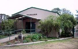 Adjungbilly Community Hall | |||||||||
Adjungbilly | |||||||||
| Coordinates | 35°4′53″S 148°24′35″E | ||||||||
| Postcode(s) | 2727 | ||||||||
| Elevation | 514 m (1,686 ft) | ||||||||
| Area | 455 km2 (175.7 sq mi)[1] | ||||||||
| Location | |||||||||
| LGA(s) | Cootamundra-Gundagai Regional Council | ||||||||
| County | Buccleuch | ||||||||
| State electorate(s) | Cootamundra | ||||||||
| Federal Division(s) | Riverina | ||||||||
| |||||||||
The (first) Tomooroma Post Office opened on 15 May 1896, was renamed Adjungbilly in 1899 and closed in 1974.[3]
The area of Adjungbilly was originally referred to as Nadjongbilla, from the Wiradjuri word nadjong meaning water and billa meaning creek, therefore referring to the area's creek with its permanent water supply.[4]
The area has a community hall and a small isolated primary school named the Bongongo Public School probably in relation to the nearby Bongongo Station.
Notes and references
- "Map of Adjungbilly".
- "Archived copy". Archived from the original on 24 March 2007. Retrieved 27 March 2008.CS1 maint: archived copy as title (link)
- Premier Postal History, Post Office List, retrieved 11 June 2009
- "Adjungbilly". Geographical Names Register (GNR) of NSW. Geographical Names Board of New South Wales.

| Wikimedia Commons has media related to Adjungbilly. |
Climate
| Climate data for Adjungbilly, NSW (Red Hill State Forest); 640 m AMSL; 35° 10′ 00.12″ S | |||||||||||||
|---|---|---|---|---|---|---|---|---|---|---|---|---|---|
| Month | Jan | Feb | Mar | Apr | May | Jun | Jul | Aug | Sep | Oct | Nov | Dec | Year |
| Average high °C (°F) | 28.7 (83.7) |
27.8 (82.0) |
25.1 (77.2) |
19.5 (67.1) |
14.5 (58.1) |
11.1 (52.0) |
10.0 (50.0) |
11.7 (53.1) |
15.3 (59.5) |
18.6 (65.5) |
21.9 (71.4) |
26.3 (79.3) |
19.2 (66.6) |
| Average low °C (°F) | 12.5 (54.5) |
12.8 (55.0) |
10.5 (50.9) |
6.7 (44.1) |
3.7 (38.7) |
1.9 (35.4) |
0.8 (33.4) |
1.5 (34.7) |
3.3 (37.9) |
5.9 (42.6) |
8.0 (46.4) |
10.8 (51.4) |
6.5 (43.7) |
| Average precipitation mm (inches) | 73.3 (2.89) |
56.1 (2.21) |
76.1 (3.00) |
78.6 (3.09) |
108.3 (4.26) |
96.5 (3.80) |
117.0 (4.61) |
118.9 (4.68) |
91.5 (3.60) |
105.3 (4.15) |
85.1 (3.35) |
70.0 (2.76) |
1,076.7 (42.4) |
| Average precipitation days (≥ 0.2 mm) | 6.5 | 5.9 | 6.3 | 8.1 | 11.8 | 12.9 | 14.5 | 15.2 | 11.5 | 12.1 | 9.2 | 7.5 | 121.5 |
| Source: Australian Bureau of Meteorology; Red Hill State Forest | |||||||||||||
gollark: It uses nonlinear apionic recursion.
gollark: The idea-generator-powered one.
gollark: Use the idea generator.
gollark: ↑ thoughts
gollark: ?tag bm25
This article is issued from Wikipedia. The text is licensed under Creative Commons - Attribution - Sharealike. Additional terms may apply for the media files.