National Register of Historic Places listings in Baxter County, Arkansas
This is a list of the National Register of Historic Places listings in Baxter County, Arkansas.
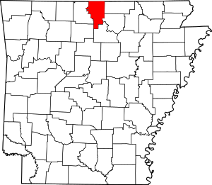
Location of Baxter County in Arkansas
This is intended to be a complete list of the properties and districts on the National Register of Historic Places in Baxter County, Arkansas, United States. The locations of National Register properties and districts for which the latitude and longitude coordinates are included below, may be seen in a map.[1]
There are 19 properties and districts listed on the National Register in the county.
- This National Park Service list is complete through NPS recent listings posted August 14, 2020.[2]
Current listings
| [3] | Name on the Register[4] | Image | Date listed[5] | Location | City or town | Description |
|---|---|---|---|---|---|---|
| 1 | Baxter County Courthouse | 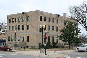 Baxter County Courthouse |
May 26, 1995 (#95000658) |
Courthouse Sq. 36°20′07″N 92°23′05″W |
Mountain Home | |
| 2 | Big Flat School Gymnasium | 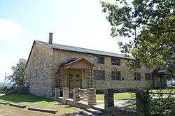 Big Flat School Gymnasium |
November 19, 1993 (#93001255) |
County Road 121 south of its junction with Highway 14 36°00′10″N 92°24′17″W |
Big Flat | |
| 3 | Buford School Building |  Buford School Building |
September 4, 1992 (#92001128) |
Highway 126 36°14′55″N 92°25′38″W |
Buford | |
| 4 | Case-Shiras-Dearmore House | 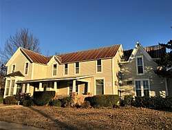 Case-Shiras-Dearmore House |
February 3, 1992 (#91000580) |
351 E. 4th St. 36°20′13″N 92°22′53″W |
Mountain Home | |
| 5 | Casey House |  Casey House |
December 4, 1975 (#75000374) |
Fairgrounds off U.S. Highway 62 36°19′26″N 92°22′56″W |
Mountain Home | |
| 6 | Cold Water School | 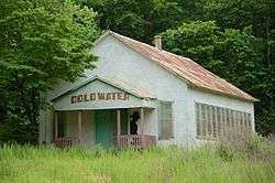 Cold Water School |
May 29, 2008 (#08000485) |
2422 County Road 73 36°08′26″N 92°15′58″W |
Big Flat | |
| 7 | Cotter Bridge | 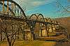 Cotter Bridge |
April 4, 1990 (#90000518) |
U.S. Highway 62B over the White River 36°16′03″N 92°32′50″W |
Cotter | |
| 8 | Old Cotter High School Gymnasium | 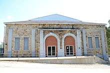 Old Cotter High School Gymnasium |
September 29, 1995 (#95001147) |
412 Powell St. 36°16′14″N 92°32′09″W |
Cotter | |
| 9 | Cotter Water Tower | 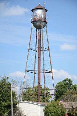 Cotter Water Tower |
January 24, 2007 (#06001280) |
Northeast of the junction of U.S. Highway 62B and State St. 36°16′34″N 92°31′46″W |
Cotter | |
| 10 | Davis House | 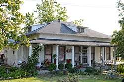 Davis House |
March 23, 1995 (#95000271) |
Southeastern corner of the junction of Wolf Street and Highway 5 36°12′35″N 92°17′10″W |
Norfork | |
| 11 | Fort Smith to Jackson Road-Talbert's Ferry Segments | September 22, 2004 (#04001030) |
Address Restricted |
Cotter | Segments of the Trail of Tears[6] | |
| 12 | Horace Mann School Historic District | 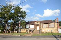 Horace Mann School Historic District |
January 29, 2007 (#06001311) |
City Hall Circle 36°12′19″N 92°17′02″W |
Norfork | |
| 13 | Sid Hutcheson Building | 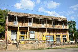 Sid Hutcheson Building |
September 30, 2014 (#14000789) |
13912 AR 5, S. 36°12′31″N 92°17′12″W |
Norfork | |
| 14 | Mountain Home Cemetery, Historic Section | February 13, 2020 (#100004895) |
147 East 11th St. 36°19′45″N 92°23′04″W |
Mountain Home | ||
| 15 | Mountain Home Commercial Historic District | 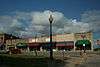 Mountain Home Commercial Historic District |
June 15, 2010 (#10000348) |
Roughly bounded on the north by East 5th St., East 9th St. on the south, South St. on the east, and Hickory St. on the west 36°20′04″N 92°23′04″W |
Mountain Home | |
| 16 | Old Joe | May 4, 1982 (#82002094) |
Address Restricted |
Norfork | ||
| 17 | Rollins Hospital | 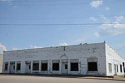 Rollins Hospital |
September 20, 2007 (#07000970) |
107 E. Main St. 36°16′58″N 92°29′40″W |
Gassville | |
| 18 | Wolf Cemetery | 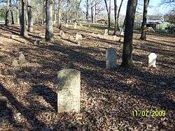 Wolf Cemetery |
March 13, 2013 (#13000063) |
County Road 68 36°09′43″N 92°15′28″W |
Norfork | |
| 19 | Jacob Wolf House |  Jacob Wolf House |
April 13, 1973 (#73000380) |
On Highway 5, west of the fork of the White and North Fork Rivers 36°12′37″N 92°17′11″W |
Norfork |
Former listings
| [3] | Name on the Register | Image | Date listed | Date removed | Location | City or town | Summary |
|---|---|---|---|---|---|---|---|
| 1 | North Fork Bridge | 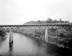 North Fork Bridge |
April 9, 1990 (#90000512) | September 29, 2015 | Highway 5, over the North Fork of the White River (North Fork River) 36°12′49″N 92°17′11″W |
Norfork |
See also
| Wikimedia Commons has media related to National Register of Historic Places in Baxter County, Arkansas. |
References
- The latitude and longitude information provided in this table was derived originally from the National Register Information System, which has been found to be fairly accurate for about 99% of listings. Some locations in this table may have been corrected to current GPS standards.
- "National Register of Historic Places: Weekly List Actions". National Park Service, United States Department of the Interior. Retrieved on August 14, 2020.
- Numbers represent an ordering by significant words. Various colorings, defined here, differentiate National Historic Landmarks and historic districts from other NRHP buildings, structures, sites or objects.
- "National Register Information System". National Register of Historic Places. National Park Service. March 13, 2009.
- The eight-digit number below each date is the number assigned to each location in the National Register Information System database, which can be viewed by clicking the number.
- "Trail Of Tears National Historic Trail: National Register Research". National Park Service. Retrieved January 22, 2013.
| Topics | |
|---|---|
| Lists by state |
|
| Lists by insular areas | |
| Lists by associated state | |
| Other areas | |
| Related | |
| |
Municipalities and communities of Baxter County, Arkansas, United States | ||
|---|---|---|
| Cities | Map of Arkansas highlighting Baxter County | |
| Towns | ||
| CDP | ||
| Unincorporated communities | ||
| Footnotes | ‡This populated place also has portions in an adjacent county or counties | |
This article is issued from Wikipedia. The text is licensed under Creative Commons - Attribution - Sharealike. Additional terms may apply for the media files.