National Register of Historic Places listings in Hot Spring County, Arkansas
This is a list of the National Register of Historic Places listings in Hot Spring County, Arkansas.
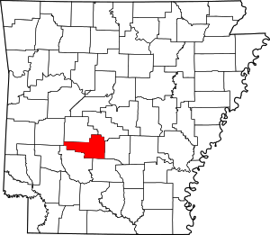
Location of Hot Spring County in Arkansas
This is intended to be a complete list of the properties and districts on the National Register of Historic Places in Hot Spring County, Arkansas, United States. The locations of National Register properties and districts for which the latitude and longitude coordinates are included below, may be seen in a map.[1]
There are 29 properties and districts listed on the National Register in the county.
- This National Park Service list is complete through NPS recent listings posted August 14, 2020.[2]
Current listings
| [3] | Name on the Register[4] | Image | Date listed[5] | Location | City or town | Description |
|---|---|---|---|---|---|---|
| 1 | Alderson-Coston House | 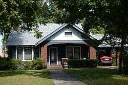 Alderson-Coston House |
May 26, 1995 (#95000657) |
204 Pine Bluff St. 34°21′43″N 92°48′33″W |
Malvern | |
| 2 | Bank of Malvern |  Bank of Malvern |
March 13, 1987 (#87000425) |
212 S. Main St. 34°21′48″N 92°48′49″W |
Malvern | |
| 3 | Billings-Cole House | 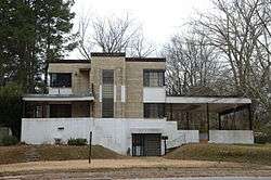 Billings-Cole House |
May 27, 2015 (#15000283) |
725 E. Page Ave. 34°21′48″N 92°48′12″W |
Malvern | |
| 4 | Blakely House | 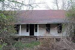 Blakely House |
May 3, 1976 (#76002142) |
West of Social Hill on Highway 84 34°20′06″N 93°01′32″W |
Social Hill | |
| 5 | Cabin No. 1 | 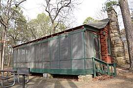 Cabin No. 1 |
April 20, 1995 (#95000455) |
Cabin area access road at Lake Catherine State Park 34°26′15″N 92°54′46″W |
Shorewood Hills | |
| 6 | Clark House | 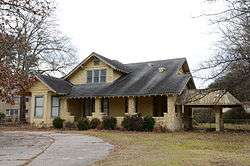 Clark House |
December 22, 1982 (#82000828) |
1324 S. Main St. 34°21′24″N 92°48′30″W |
Malvern | |
| 7 | Couchwood | 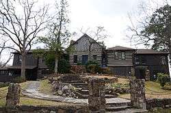 Couchwood |
December 4, 1986 (#86003582) |
On the grounds of the Couchwood estate, 601 Couchwood Rd.[6] 34°26′47″N 92°54′50″W |
Shorewood Hills | Extends into Garland County; listing encompasses artwork of Dionicio Rodriguez on the private estate of Harvey C. Couch. |
| 8 | Couchwood Historic District | 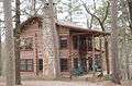 Couchwood Historic District |
May 17, 2001 (#01000487) |
601 Couchwood Rd. 34°26′50″N 92°54′50″W |
Hot Springs | Extends into Garland County; listing encompasses buildings and structures of the private estate of Harvey C. Couch. |
| 9 | Gatewood House | 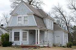 Gatewood House |
July 24, 1992 (#92000928) |
235 Pine Bluff St. 34°21′41″N 92°48′30″W |
Malvern | |
| 10 | Hodges House | 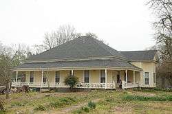 Hodges House |
June 2, 1995 (#95000683) |
Highway 7 34°16′23″N 93°08′53″W |
Bismarck | |
| 11 | Hot Spring County Courthouse | 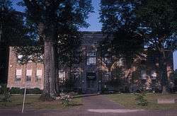 Hot Spring County Courthouse |
November 7, 1996 (#96001271) |
210 Locust St. 34°21′46″N 92°48′53″W |
Malvern | |
| 12 | Hot Springs Railroad Roundhouse | 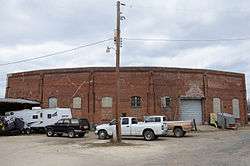 Hot Springs Railroad Roundhouse |
May 29, 2003 (#03000462) |
132 Front St. 34°21′53″N 92°48′59″W |
Malvern | |
| 13 | Jones Mill Site (3HS28) | September 12, 1988 (#87001385) |
Address Restricted |
Jones Mill | ||
| 14 | Lake Catherine Quarry | September 11, 1975 (#75000388) |
Address Restricted |
Malvern | ||
| 15 | Lake Catherine State Park-Bridge No. 2 | 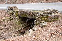 Lake Catherine State Park-Bridge No. 2 |
May 28, 1992 (#92000528) |
Highway 171 west of Slunger Creek in Lake Catherine State Park 34°25′46″N 92°56′21″W |
Shorewood Hills | |
| 16 | Lake Catherine State Park-Cabin No. 2 | 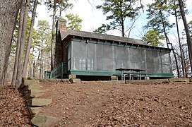 Lake Catherine State Park-Cabin No. 2 |
May 28, 1992 (#92000526) |
Cabin area access road in Lake Catherine State Park 34°26′15″N 92°54′45″W |
Shorewood Hills | |
| 17 | Lake Catherine State Park-Cabin No. 3 | 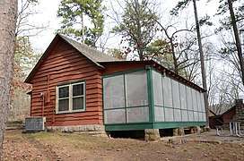 Lake Catherine State Park-Cabin No. 3 |
May 28, 1992 (#92000527) |
Cabin area access road in Lake Catherine State Park 34°26′15″N 92°54′44″W |
Shorewood Hills | |
| 18 | Lake Catherine State Park-Nature Cabin | 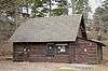 Lake Catherine State Park-Nature Cabin |
May 28, 1992 (#92000535) |
Camping area access road in Lake Catherine State Park 34°26′15″N 92°55′03″W |
Shorewood Hills | |
| 19 | Lake Catherine State Park Prisoner of War Structures | January 24, 2017 (#100000553) |
Campground, Lake Catherine State Park 34°26′15″N 92°55′05″W |
Hot Springs vicinity | Stone retaining wall and outdoor oven built in part by CCC and in part by German POW labor | |
| 20 | Lawyers' Row Historic District | 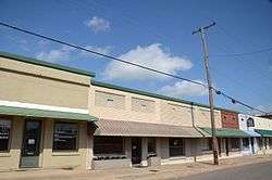 Lawyers' Row Historic District |
September 28, 2015 (#15000625) |
118, 120, 130, 132 W. 2nd St. 34°21′49″N 92°48′53″W |
Malvern | |
| 21 | Lono Gymnasium | January 21, 2020 (#100004896) |
11702 AR 222 34°12′30″N 92°42′30″W |
Lono | ||
| 22 | Malvern Commercial Historic District | 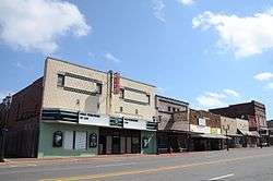 Malvern Commercial Historic District |
September 28, 2015 (#15000626) |
Bounded by W. 1st., S. Main, W. 5th & Locust Sts. 34°21′46″N 92°48′50″W |
Malvern | |
| 23 | Malvern Rosenwald School | 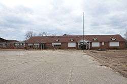 Malvern Rosenwald School |
September 28, 2005 (#05001075) |
836 Acme St. 34°21′45″N 92°49′18″W |
Malvern | |
| 24 | Missouri-Pacific Railroad Depot-Malvern | 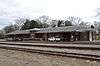 Missouri-Pacific Railroad Depot-Malvern |
June 11, 1992 (#92000615) |
1st St. 34°21′56″N 92°48′49″W |
Malvern | |
| 25 | Morrison Plantation Smokehouse | December 28, 1977 (#77000254) |
Off Interstate 30 34°16′12″N 92°56′50″W |
Saginaw | ||
| 26 | Pine Bluff Street Historic District | 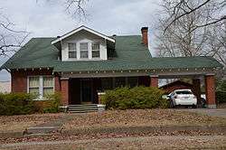 Pine Bluff Street Historic District |
February 16, 1999 (#99000154) |
Pine Bluff St., roughly from Bois D'Arc to McNeal St. 34°21′42″N 92°48′17″W |
Malvern | |
| 27 | Remmel Dam | 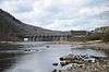 Remmel Dam |
September 4, 1992 (#92001084) |
Remmel Dam Rd. 34°25′37″N 92°53′38″W |
Jones Mill | |
| 28 | Rockport Cemetery | 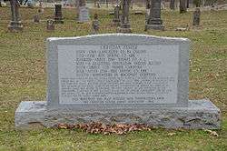 Rockport Cemetery |
January 28, 2002 (#01001527) |
U.S. Route 270 34°22′48″N 92°49′57″W |
Rockport | |
| 29 | Strauss House | 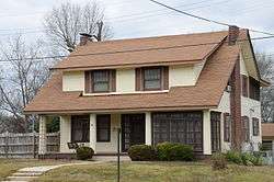 Strauss House |
December 22, 1982 (#82000830) |
528 E. Page St. 34°21′50″N 92°48′26″W |
Malvern |
Former listings
| [3] | Name on the Register | Image | Date listed | Date removed | Location | City or town | Summary |
|---|---|---|---|---|---|---|---|
| 1 | Bethel African Methodist Episcopal Church | May 26, 2004 (#04000496) | June 12, 2013 | 519 West Page Street 34°21′35″N 92°48′58″W |
Malvern | ||
| 2 | Burks Service Station | June 9, 2000 (#00000630) | October 18, 2002 | Jct. of Page Ave. and Sullenberger |
Malvern | ||
| 3 | Old Rockport Bridge | 1982 (#82000829) | August 11, 1999 | W of Rockport across Ouachita River |
Rockport vicinity | Damaged by flooding in 1987, completely destroyed by another flood in 1990. |
See also
| Wikimedia Commons has media related to National Register of Historic Places in Hot Spring County, Arkansas. |
References
- The latitude and longitude information provided in this table was derived originally from the National Register Information System, which has been found to be fairly accurate for about 99% of listings. Some locations in this table may have been corrected to current GPS standards.
- "National Register of Historic Places: Weekly List Actions". National Park Service, United States Department of the Interior. Retrieved on August 14, 2020.
- Numbers represent an ordering by significant words. Various colorings, defined here, differentiate National Historic Landmarks and historic districts from other NRHP buildings, structures, sites or objects.
- "National Register Information System". National Register of Historic Places. National Park Service. March 13, 2009.
- The eight-digit number below each date is the number assigned to each location in the National Register Information System database, which can be viewed by clicking the number.
- Location derived from the Couchwood Historic District article of the Encyclopedia of Arkansas History and Culture; the NRIS lists the site as "Address Restricted"
| Topics | |
|---|---|
| Lists by state |
|
| Lists by insular areas | |
| Lists by associated state | |
| Other areas | |
| Related | |
| |
Municipalities and communities of Hot Spring County, Arkansas, United States | ||
|---|---|---|
| Cities | Map of Arkansas highlighting Hot Spring County | |
| Towns | ||
| Census-designated place | ||
| Unincorporated communities |
| |
| Townships |
| |
| Ghost towns |
| |
This article is issued from Wikipedia. The text is licensed under Creative Commons - Attribution - Sharealike. Additional terms may apply for the media files.