Chesapeake Beach, Maryland
Chesapeake Beach is a town in Calvert County, Maryland, United States. Its major attractions include the Chesapeake Beach Railway Station, the Chesapeake Beach Rail Trail, a water park, marinas, piers, and charter boat fishing. The town's population was recorded as 5,753 in the 2010 census.
Chesapeake Beach, Maryland | |
|---|---|
| Town of Chesapeake Beach | |
_at_Maryland_State_Route_261_(Bayside_Road)_in_Chesapeake_Beach%2C_Calvert_County%2C_Maryland.jpg) | |
| Nickname(s): "Twin Beaches" | |
 Location of Chesapeake Beach, Maryland | |
| Coordinates: 38°41′42″N 76°32′10″W | |
| Country | |
| State | |
| County | |
| Incorporated | 1886 (repealed 1888, reincorporated 1894)[1] |
| Government | |
| • Mayor | Pat "Irish" Mahoney |
| Area | |
| • Total | 2.78 sq mi (7.21 km2) |
| • Land | 2.69 sq mi (6.97 km2) |
| • Water | 0.09 sq mi (0.23 km2) |
| Elevation | 49 ft (15 m) |
| Population | |
| • Total | 5,753 |
| • Estimate (2019)[4] | 6,030 |
| • Density | 2,239.14/sq mi (864.65/km2) |
| Time zone | UTC-5 (Eastern (EST)) |
| • Summer (DST) | UTC-4 (EDT) |
| ZIP code | 20732 |
| Area code(s) | 301 |
| FIPS code | 24-15925 |
| GNIS feature ID | 0589951 |
| Website | www |
Geography
Chesapeake Beach is located at 38°41′42″N 76°32′10″W (38.695070, -76.536125).[5]
According to the United States Census Bureau, the town has a total area of 2.79 square miles (7.23 km2), of which 2.71 square miles (7.02 km2) is land and 0.08 square miles (0.21 km2) is water.[6]
The city has grown out from the intersection of Fishing Creek and the Chesapeake Bay. The creek has been dredged to allow pleasure craft, commercial fisherman and a few small US Navy vessels to dock in the city.
The southern end of the city remains heavily wooded and is distinguished by the large sandstone cliffs called the Randle Cliffs. These cliffs, and others along the Western Shore of the Chesapeake Bay, tower as high as 180 feet above the water and are constantly eroding due to freeze/thaw and wave action. The debris from these cliffs has formed a number of shallow sand bars which makes navigation by boat near the cliffs very difficult and the water very shallow for hundreds of yards into the bay.
Transportation
_at_Maryland_State_Route_260_(Chesapeake_Beach_Road)_in_Chesapeake_Beach%2C_Calvert_County%2C_Maryland.jpg)
The primary method of travel to and from Chesapeake Beach is presently by road, and two state highways currently serve the town. Maryland Route 260 follows Chesapeake Beach Road into the town, providing a direct connection between the town and both Maryland Route 2 and Maryland Route 4. MD 2 leads north to Baltimore, while MD 4 heads northwest to Washington, D.C.. Maryland Route 261 is the other highway directly serving the town, following Bayside Road from south to north through Chesapeake Beach and providing connections to other communities along the Chesapeake Bay.
Demographics
| Historical population | |||
|---|---|---|---|
| Census | Pop. | %± | |
| 1940 | 326 | — | |
| 1950 | 504 | 54.6% | |
| 1960 | 731 | 45.0% | |
| 1970 | 934 | 27.8% | |
| 1980 | 1,408 | 50.7% | |
| 1990 | 2,403 | 70.7% | |
| 2000 | 3,180 | 32.3% | |
| 2010 | 5,753 | 80.9% | |
| Est. 2019 | 6,030 | [4] | 4.8% |
| U.S. Decennial Census[7] | |||
2010 census
As of the census[3] of 2010, there were 5,753 people, 2,134 households, and 1,520 families residing in the town. The population density was 2,122.9 inhabitants per square mile (819.7/km2). There were 2,354 housing units at an average density of 868.6 per square mile (335.4/km2). The racial makeup of the town was 84.8% White, 9.8% African American, 0.6% Native American, 1.4% Asian, 0.6% from other races, and 2.8% from two or more races. Hispanic or Latino of any race were 2.8% of the population.
There were 2,134 households, of which 43.1% had children under the age of 18 living with them, 51.4% were married couples living together, 15.2% had a female householder with no husband present, 4.6% had a male householder with no wife present, and 28.8% were non-families. 21.6% of all households were made up of individuals, and 5.6% had someone living alone who was 65 years of age or older. The average household size was 2.70 and the average family size was 3.15.
The median age in the town was 36.2 years. 28.6% of residents were under the age of 18; 6.8% were between the ages of 18 and 24; 29.6% were from 25 to 44; 27.7% were from 45 to 64; and 7.1% were 65 years of age or older. The gender makeup of the town was 48.1% male and 51.9% female.
2000 census
As of the census[8] of 2000, there were 3,180 people, 1,217 households, and 862 families residing in the town. The population density was 1,144.7 people per square mile (441.7/km2). There were 1,331 housing units at an average density of 479.1 per square mile (184.9/km2). The racial makeup of the town was 91.51% White, 5.28% African American, 0.35% Native American, 1.10% Asian, 0.38% from other races, and 1.38% from two or more races. Hispanic or Latino of any race were 1.42% of the population.
There were 1,217 households, out of which 35.2% had children under the age of 18 living with them, 52.7% were married couples living together, 12.9% had a female householder with no husband present, and 29.1% were non-families. 21.6% of all households were made up of individuals, and 5.4% had someone living alone who was 65 years of age or older. The average household size was 2.61 and the average family size was 3.03.
In the town, the population was spread out, with 27.2% under the age of 18, 7.4% from 18 to 24, 34.4% from 25 to 44, 24.0% from 45 to 64, and 7.0% who were 65 years of age or older. The median age was 36 years. For every 100 females, there were 99.1 males. For every 100 females age 18 and over, there were 93.8 males.
The median income for a household in the town was $68,365, and the median income for a family was $74,167. Males had a median income of $43,125 versus $35,865 for females. The per capita income for the town was $29,616. About 1.6% of families and 3.8% of the population were below the poverty line, including 3.8% of those under age 18 and 5.5% of those age 65 or over.
History

Chesapeake Beach was established as a resort community at the end of the Chesapeake Beach Railway, a short line railroad from Washington, DC. It was the site of many slot machines in the early twentieth century (despite efforts to prohibit them)[9] as part of the "Little Nevada" area of southern Maryland. Between steamer ships from Baltimore and trains from Washington, the weekend population of Chesapeake Beach reached into the 10,000s during the 1920s, until economic depression, and a bad hotel fire, brought an end to the railroad. The construction of the Bay Bridge to the Eastern Shore of Maryland in the 1950s enabled many of the visitors who used to spend their summers in Chesapeake Beach to now spend their time in Ocean City, Maryland instead. A museum at the old railroad station still exists today in Chesapeake Beach with many historic photos and an old passenger car from the railroad. It was listed on the National Register of Historic Places in 1980. In the new millennium a boardwalk and pier, and a new condominium development have risen in Chesapeake Beach. There is also a recreational water park with water slides, a newly opened resort spa hotel, and a seafood restaurant right on the bay. The Herrington Harbour (Rose Haven) marina resort, which was voted by Marina Dock Age magazine as the best marina in the United States, is a few miles north.
Chesapeake Beach is also host to the United States Naval Research Laboratory Chesapeake Bay Detachment that experiments with various military radar systems and fire suppression technology. Perched atop the sandstone cliffs along the Western Shore of the Chesapeake Bay the lab is able to use their radars against a variety of surface and air targets in the Bay. Nearby Naval Air Station Patuxent River has several aircraft that assist in the Research lab's mission.[10]
Hurricane Isabel struck Chesapeake Beach and the adjacent city of North Beach, Maryland in 2003. The storm surge pushed flood waters into both towns, damaging many homes beyond repair in North Beach, and knocking out electrical services for nearly one week.
Notable people
- Tom Clancy, author
- Thomas V. Mike Miller, Jr., the current president of the Maryland Senate
- Christopher Wilkinson, screenwriter, producer, and director
References
- "Chesapeake Beach". Maryland Manual. Retrieved 25 June 2017.
- "2019 U.S. Gazetteer Files". United States Census Bureau. Retrieved July 25, 2020.
- "U.S. Census website". United States Census Bureau. Retrieved 2013-01-25.
- "Population and Housing Unit Estimates". United States Census Bureau. May 24, 2020. Retrieved May 27, 2020.
- "US Gazetteer files: 2010, 2000, and 1990". United States Census Bureau. 2011-02-12. Retrieved 2011-04-23.
- "US Gazetteer files 2010". United States Census Bureau. Archived from the original on 2012-01-25. Retrieved 2013-01-25.
- "Census of Population and Housing". Census.gov. Retrieved June 4, 2015.
- "U.S. Census website". United States Census Bureau. Retrieved 2008-01-31.
- Chesapeake Beach Hotel Co. v. Hall, 121 Md. 643; 89 A. 445 (1913).
- http://www.nrl.navy.mil/field-sites/vxs-1/
Brett Cecil, Current starting pitcher for the Toronto Blue Jays
External links
| Wikimedia Commons has media related to Chesapeake Beach, Maryland. |
- Chesapeake Beach Railway Museum
- Chesapeake Beach official website
- Chesapeake Beach Naval Research lab
- Bruce "Snake" Gabrielson Surf Art Gallery and Museum
Municipalities and communities of Calvert County, Maryland, United States | ||
|---|---|---|
| Towns | 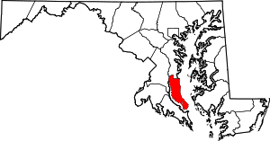 | |
| CDPs | ||
| Other communities | ||
| Ghost town | ||
| Principal cities (and city-like entities) |
|   | |||||||
|---|---|---|---|---|---|---|---|---|---|
| Counties (and county equivalents) |
| ||||||||
The District of Columbia itself, and Virginia's incorporated cities, are county equivalents. Virginia's incorporated cities are listed under their surrounding county. The incorporated cities bordering more than one county (Alexandria, Falls Church and Fredericksburg) are listed under the county they were part of before incorporation as a city. Some unincorporated areas and census-designated places like Silver Spring and Bethesda in Maryland, Reston in Virginia, as well as the County of Arlington in Virginia are also treated as city-like entities (or principal cities) even though they have not been legally incorporated as such. | |||||||||
| Authority control |
|
|---|