Sullivan, Indiana
Sullivan is a city in Hamilton Township, Sullivan County, Indiana, United States. The population was 4,249 at the 2010 census. It is part of the Terre Haute Metropolitan Statistical Area. The city is the county seat of Sullivan County.[6]
Sullivan, Indiana | |
|---|---|
| City of Sullivan | |
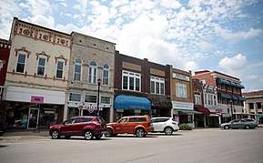
 Downtown Sullivan | |
| Nickname(s): Home of the Golden Arrows | |
| Motto(s): Take time to care | |
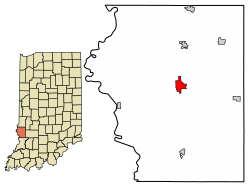
 Location of Sullivan in Sullivan County, Indiana. | |
| Coordinates: 39°5′49″N 87°24′23″W | |
| Country | |
| State | |
| County | Sullivan |
| Township | Hamilton |
| Government | |
| • Mayor | Clint Lamb (D) |
| • Chief of Police | Scott McCammon |
| • Building Commissioner | Brian D. Pound |
| • Street Superintendent | Clint Lamb |
| Area | |
| • Total | 1.88 sq mi (4.86 km2) |
| • Land | 1.88 sq mi (4.86 km2) |
| • Water | 0.00 sq mi (0.00 km2) 0% |
| Elevation | 528 ft (161 m) |
| Population | |
| • Total | 4,249 |
| • Estimate (2019)[4] | 4,093 |
| • Density | 2,181.77/sq mi (842.49/km2) |
| Time zone | UTC-5 (EST) |
| • Summer (DST) | UTC-4 (EDT) |
| ZIP codes | 47864, 47882 |
| Area code(s) | 812 |
| FIPS code | 18-74006[5] |
| GNIS feature ID | 444366 |
| Website | www |
History
The Sullivan post office has been in operation since 1843.[7]
Geography
Sullivan is located at 39°5′49″N 87°24′23″W (39.096888, -87.406447).[8]
According to the 2010 census, Sullivan has a total area of 1.88 square miles (4.87 km2), all land.[9]
Demographics
| Historical population | |||
|---|---|---|---|
| Census | Pop. | %± | |
| 1860 | 949 | — | |
| 1870 | 1,396 | 47.1% | |
| 1880 | 2,161 | 54.8% | |
| 1890 | 2,222 | 2.8% | |
| 1900 | 3,118 | 40.3% | |
| 1910 | 4,115 | 32.0% | |
| 1920 | 4,489 | 9.1% | |
| 1930 | 5,306 | 18.2% | |
| 1940 | 5,077 | −4.3% | |
| 1950 | 5,423 | 6.8% | |
| 1960 | 4,979 | −8.2% | |
| 1970 | 4,683 | −5.9% | |
| 1980 | 4,774 | 1.9% | |
| 1990 | 4,663 | −2.3% | |
| 2000 | 4,617 | −1.0% | |
| 2010 | 4,249 | −8.0% | |
| Est. 2019 | 4,093 | [4] | −3.7% |
| U.S. Decennial Census[10] | |||

2010 census
As of the census[3] of 2010, there were 4,249 people, 1,835 households, and 1,073 families living in the city. The population density was 2,260.1 inhabitants per square mile (872.6/km2). There were 2,110 housing units at an average density of 1,122.3 per square mile (433.3/km2). The racial makeup of the city was 97.7% White, 0.1% African American, 0.4% Native American, 0.2% Asian, 0.4% from other races, and 1.2% from two or more races. Hispanic or Latino of any race were 1.4% of the population.
There were 1,835 households, of which 29.4% had children under the age of 18 living with them, 39.2% were married couples living together, 14.3% had a female householder with no husband present, 5.0% had a male householder with no wife present, and 41.5% were non-families. 37.1% of all households were made up of individuals, and 18.1% had someone living alone who was 65 years of age or older. The average household size was 2.27 and the average family size was 2.96.
The median age in the city was 39.8 years. 23.8% of residents were under the age of 18; 9.3% were between the ages of 18 and 24; 23.4% were from 25 to 44; 25% were from 45 to 64; and 18.5% were 65 years of age or older. The gender makeup of the city was 46.3% male and 53.7% female.
2000 census
As of the census[5] of 2000, there were 4,617 people, 1,958 households, and 1,176 families living in the city. The population density was 2,410.1 people per square mile (928.5/km2). There were 2,264 housing units at an average density of 1,181.8 per square mile (455.3/km2). The racial makeup of the city was 97.92% White, 0.50% African American, 0.37% Native American, 0.24% Asian, 0.13% from other races, and 0.84% from two or more races. Hispanic or Latino of any race were 0.82% of the population.
There were 1,958 households, out of which 28.5% had children under the age of 18 living with them, 45.0% were married couples living together, 11.6% had a female householder with no husband present, and 39.9% were non-families. 36.0% of all households were made up of individuals, and 19.9% had someone living alone who was 65 years of age or older. The average household size was 2.26 and the average family size was 2.95.
In the city, the population was spread out, with 23.5% under the age of 18, 8.9% from 18 to 24, 25.5% from 25 to 44, 22.0% from 45 to 64, and 20.2% who were 65 years of age or older. The median age was 39 years. For every 100 females, there were 83.9 males. For every 100 females age 18 and over, there were 77.5 males.
The median income for a household in the city was $26,115, and the median income for a family was $35,042. Males had a median income of $28,773 versus $21,992 for females. The per capita income for the city was $17,717. About 13.6% of families and 16.6% of the population were below the poverty line, including 22.2% of those under age 18 and 11.0% of those age 65 or over.
Education
The town is served by the Southwest School Corporation, and students go to Sullivan High School.
Sullivan has a public library, a branch of the Sullivan County Public Library.[11]
Notable people
- Will H. Hays (1879–1954) - Chairman of the Republican National Committee (1918–21), Postmaster General of the United States (1921-22), President of the Motion Picture Producers and Distributors of America (1922–45) and namesake of the movie industry's Hays Code.
- Nelson Poynter (1903–1978) - Newspaperman and founder of the Poynter Institute.
References
- "2019 U.S. Gazetteer Files". United States Census Bureau. Retrieved July 16, 2020.
- "US Board on Geographic Names". United States Geological Survey. 2007-10-25. Retrieved 2008-01-31.
- "U.S. Census website". United States Census Bureau. Retrieved 2012-12-11.
- "Population and Housing Unit Estimates". United States Census Bureau. May 24, 2020. Retrieved May 27, 2020.
- "U.S. Census website". United States Census Bureau. Retrieved 2008-01-31.
- "Find a County". National Association of Counties. Retrieved 2011-06-07.
- "Sullivan County". Jim Forte Postal History. Retrieved August 29, 2016.
- "US Gazetteer files: 2010, 2000, and 1990". United States Census Bureau. 2011-02-12. Retrieved 2011-04-23.
- "G001 - Geographic Identifiers - 2010 Census Summary File 1". United States Census Bureau. Archived from the original on 2020-02-13. Retrieved 2015-07-29.
- "Census of Population and Housing". Census.gov. Retrieved June 4, 2015.
- "Locations". Sullivan County Public Library. Retrieved 15 March 2018.
External links
- Sullivan Daily Times (local newspaper)
- Sullivan County Historical Society (maintains a museum and a newsletter)
- Sullivan County Public Library
![]()
