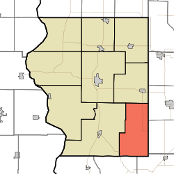
Jefferson Township, Sullivan County, Indiana
Jefferson Township is one of nine townships in Sullivan County, Indiana, United States. At the 2010 census, its population was 417 and it contained 234 housing units.[1]
Jefferson Township | |
|---|---|
 Location in Sullivan County | |
| Coordinates: 38°57′43″N 87°17′19″W | |
| Country | |
| State | |
| County | Sullivan |
| Government | |
| • Type | Indiana township |
| Area | |
| • Total | 42.95 sq mi (111.2 km2) |
| • Land | 42.42 sq mi (109.9 km2) |
| • Water | 0.53 sq mi (1.4 km2) 1.23% |
| Elevation | 623 ft (190 m) |
| Population (2010) | |
| • Total | 417 |
| • Density | 9.8/sq mi (3.8/km2) |
| ZIP codes | 47528, 47838, 47848, 47882 |
| GNIS feature ID | 453498 |
Geography
According to the 2010 census, the township has a total area of 42.95 square miles (111.2 km2), of which 42.42 square miles (109.9 km2) (or 98.77%) is land and 0.53 square miles (1.4 km2) (or 1.23%) is water.[1]
Unincorporated towns
(This list is based on USGS data and may include former settlements.)
Adjacent townships
- Cass Township (north)
- Stockton Township, Greene County (northeast)
- Stafford Township, Greene County (east)
- Vigo Township, Knox County (south)
- Widner Township, Knox County (southwest)
- Haddon Township (west)
Cemeteries
The township contains six cemeteries: Hale, McDade, Pirtle, Posey, Smith and Woodward.
Lakes
- Motorboat Lake
- Red Lake
- South Lake
- T Lake
- Twin Lake
School districts
- Northeast School Corporation
Political districts
- Indiana's 8th congressional district
- State House District 45
- State Senate District 39
gollark: My hosting costs probably £5/month in power and about that much (maybe) in amortized server hardware cost.
gollark: Yes.
gollark: I could probably script it, but meh.
gollark: `scp file.whatever loki:/data/public`, link to https://i.osmarks.tk/file, done.
gollark: Apart from the upload being awful, my setup is very easy to use.
References
- United States Census Bureau 2008 TIGER/Line Shapefiles
- United States Board on Geographic Names (GNIS)
- IndianaMap
- "Population, Housing Units, Area, and Density: 2010 - County -- County Subdivision and Place -- 2010 Census Summary File 1". United States Census. Archived from the original on 12 February 2020. Retrieved 10 May 2013.
This article is issued from Wikipedia. The text is licensed under Creative Commons - Attribution - Sharealike. Additional terms may apply for the media files.