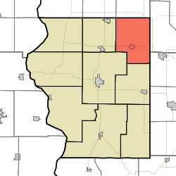
Jackson Township, Sullivan County, Indiana
Jackson Township is one of nine townships in Sullivan County, Indiana, United States. As of the 2010 census, its population was 1,904 and it contained 843 housing units.[1]
Jackson Township | |
|---|---|
 Location in Sullivan County | |
| Coordinates: 39°12′21″N 87°17′49″W | |
| Country | |
| State | |
| County | Sullivan |
| Government | |
| • Type | Indiana township |
| Area | |
| • Total | 44.12 sq mi (114.3 km2) |
| • Land | 43.26 sq mi (112.0 km2) |
| • Water | 0.86 sq mi (2.2 km2) 1.95% |
| Elevation | 525 ft (160 m) |
| Population (2010) | |
| • Total | 1,904 |
| • Density | 44/sq mi (17/km2) |
| ZIP codes | 47438, 47850, 47855, 47858, 47866, 47879, 47882 |
| GNIS feature ID | 453470 |
Geography
According to the 2010 census, the township has a total area of 44.12 square miles (114.3 km2), of which 43.26 square miles (112.0 km2) (or 98.05%) is land and 0.86 square miles (2.2 km2) (or 1.95%) is water.[1]
Cities and towns
Unincorporated communities
Adjacent townships
- Pierson Township, Vigo County (north)
- Lewis Township, Clay County (east)
- Wright Township, Greene County (southeast)
- Cass Township (south)
- Hamilton Township (southwest)
- Curry Township (west)
- Linton Township, Vigo County (northwest)
Cemeteries
The township contains these two cemeteries: Knights of Columbus and Mount Pleasant.
Lakes
- Hickory Lake
Landmarks
School districts
- Northeast School Corporation
Political districts
- Indiana's 8th congressional district
- State House District 45
- State Senate District 39
gollark: Well, you may want "whitespace" or "not whitespace", deterministic serialization in some way, and control over what happens to invalid types.
gollark: Unfortunately, like many CC things it doesn't seem that customizable and like many neat CC:T things I can't use it because backward compatibility.
gollark: `unserializeJSON` is new, though.
gollark: `textutils.serialiseJSON` exists in CC:T now, fortunately.
gollark: Yes, the async stuff is kind of irritating to reason about and potatOS has a good coroutine manager.
References
- United States Census Bureau 2008 TIGER/Line Shapefiles
- United States Board on Geographic Names (GNIS)
- IndianaMap
- "Population, Housing Units, Area, and Density: 2010 - County -- County Subdivision and Place -- 2010 Census Summary File 1". United States Census. Archived from the original on 2020-02-12. Retrieved 2013-05-10.
This article is issued from Wikipedia. The text is licensed under Creative Commons - Attribution - Sharealike. Additional terms may apply for the media files.