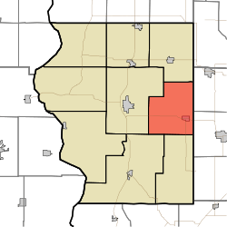
Cass Township, Sullivan County, Indiana
Cass Township is one of nine townships in Sullivan County, Indiana, USA. As of the 2010 census, its population was 2,074 and it contained 975 housing units.[1]
Cass Township | |
|---|---|
 Location in Sullivan County | |
| Coordinates: 39°05′07″N 87°17′40″W | |
| Country | |
| State | |
| County | Sullivan |
| Government | |
| • Type | Indiana township |
| Area | |
| • Total | 39.46 sq mi (102.2 km2) |
| • Land | 37.8 sq mi (98 km2) |
| • Water | 1.67 sq mi (4.3 km2) 4.23% |
| Elevation | 531 ft (162 m) |
| Population (2010) | |
| • Total | 2,074 |
| • Density | 54.9/sq mi (21.2/km2) |
| ZIP codes | 47438, 47848, 47882 |
| GNIS feature ID | 453168 |
Geography
According to the 2010 census, the township has a total area of 39.46 square miles (102.2 km2), of which 37.8 square miles (98 km2) (or 95.79%) is land and 1.67 square miles (4.3 km2) (or 4.23%) is water.[1]
Cities, towns, villages
Unincorporated towns
- Baker at 39.130598°N 87.312517°W
- Cass at 39.086987°N 87.278627°W
- Gambill at 39.048933°N 87.259737°W
- Greenville at 39.140875°N 87.301961°W
- Hawton at 39.126431°N 87.311128°W
- Jericho at 39.061432°N 87.297516°W
- Scotchtown at 39.075043°N 87.297794°W
- Shiloh at 39.038932°N 87.292516°W
- Stringtown at 39.053377°N 87.297516°W
(This list is based on USGS data and may include former settlements.)
Extinct towns
(These towns are listed as "historical" by the USGS.)
Adjacent townships
- Jackson Township (north)
- Wright Township, Greene County (east)
- Stockton Township, Greene County (southeast)
- Jefferson Township (south)
- Haddon Township (southwest)
- Hamilton Township (west)
Cemeteries
The township contains these five cemeteries: Burris, Clayton Cemeteries (historical), Deckard, Dugger and Houck.
Major highways
Lakes
- Greenbriar Lake
School districts
- Northeast School Corporation
Political districts
- Indiana's 8th congressional district
- State House District 45
- State Senate District 39
gollark: I was disappointed by the lack of squid participating in squid game.
gollark: ?urban apioform
gollark: > paying for programming languages
gollark: MP3 bad, though?
gollark: osmarkshypotheticalchatprotocol™ is much better.
References
- United States Census Bureau 2008 TIGER/Line Shapefiles
- United States Board on Geographic Names (GNIS)
- IndianaMap
- "Population, Housing Units, Area, and Density: 2010 - County -- County Subdivision and Place -- 2010 Census Summary File 1". United States Census. Archived from the original on 2020-02-12. Retrieved 2013-05-10.
This article is issued from Wikipedia. The text is licensed under Creative Commons - Attribution - Sharealike. Additional terms may apply for the media files.