Silverdale, Queensland
Silverdale is a rural locality in the Scenic Rim Region, Queensland, Australia.[2] In the 2016 census, Silverdale had a population of 120 people.[1]
| Silverdale Queensland | |||||||||||||||
|---|---|---|---|---|---|---|---|---|---|---|---|---|---|---|---|
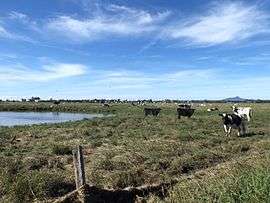
 Paddocks along Kengoon Road, 2015 | |||||||||||||||
 Silverdale | |||||||||||||||
| Coordinates | 27.8880°S 152.5966°E | ||||||||||||||
| Population | 120 (2016 census)[1] | ||||||||||||||
| • Density | 3.09/km2 (8.0/sq mi) | ||||||||||||||
| Postcode(s) | 4307 | ||||||||||||||
| Area | 38.8 km2 (15.0 sq mi) | ||||||||||||||
| Time zone | AEST (UTC+10:00) | ||||||||||||||
| LGA(s) | Scenic Rim Region | ||||||||||||||
| State electorate(s) | Scenic Rim | ||||||||||||||
| Federal Division(s) | Wright | ||||||||||||||
| |||||||||||||||
Geography
Silverdale is located in the Fassifern Valley farming area along the Cunningham Highway. The eastern boundary of Silverdale is marked by Warrill Creek, a tributary of the Bremer River.
History
Silverdale State School opened on 23 May 1910. It closed in 1962.[3]
At the 2011 census the locality and surrounds recorded a population of 434.[4]
Facilities
Silverdale has one of more than 30 cattle tick clearing facilities in Queensland.[5]
Events
The locality is home to the Annual Silverdale Show and Sale.
gollark: We do have dedicated oxygen import pipelines and arc furnaces nowadays. But it is hardly ideal.
gollark: Rust requires oxidation too.
gollark: Only ironically.
gollark: It interfaced with a few C things.
gollark: Legacy code.
References
- Australian Bureau of Statistics (27 June 2017). "Silverdale (SSC)". 2016 Census QuickStats. Retrieved 20 October 2018.

- "Silverdale - locality in Scenic Rim Region (entry 45187)". Queensland Place Names. Queensland Government. Retrieved 17 November 2019.
- Queensland Family History Society (2010), Queensland schools past and present (Version 1.01 ed.), Queensland Family History Society, ISBN 978-1-921171-26-0
- Australian Bureau of Statistics (31 October 2012). "Mundbilla (State Suburb)". 2011 Census QuickStats. Retrieved 31 March 2015.

- "Cattle tick clearing facilities". Department of Agriculture and Fisheries. 2 August 2013. Retrieved 31 March 2015.
Further reading
- Pfeffer, Collin; Miller, Lawrence; Yarrow, Robert A; Engelsburg State School Centenary Association (Kalbar, Qld.) (1979), Engelsburg State School centenary book : including history of:- Fassifern Station, Fassifern Valley, Charlwood, Silverdale, Obum Obum, Frazerview and Moogerah Dam Provisional School, Engelsburg State School Centenary Celebrations Association, ISBN 978-0-9595324-0-1
External links
![]()
This article is issued from Wikipedia. The text is licensed under Creative Commons - Attribution - Sharealike. Additional terms may apply for the media files.