Allandale, Queensland
Allandale is a rural locality in the Scenic Rim Region, Queensland, Australia.[2] In the 2016 census, Allandale had a population of 56 people.[1]
| Allandale Queensland | |||||||||||||||
|---|---|---|---|---|---|---|---|---|---|---|---|---|---|---|---|
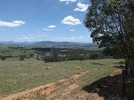 Paddocks and Mount French, 2016 | |||||||||||||||
 Allandale | |||||||||||||||
| Coordinates | 27°57′S 152°44′E | ||||||||||||||
| Population | 56 (2016 census)[1] | ||||||||||||||
| • Density | 1.148/km2 (2.972/sq mi) | ||||||||||||||
| Postcode(s) | 4310 | ||||||||||||||
| Area | 48.8 km2 (18.8 sq mi) | ||||||||||||||
| LGA(s) | Scenic Rim Region | ||||||||||||||
| State electorate(s) | Scenic Rim | ||||||||||||||
| Federal Division(s) | Wright | ||||||||||||||
| |||||||||||||||
Geography
There are no major roads in Allandale.
Teviot Brook flows through the north of Allandale. Some of the land is used for agricultural purposes. The southeast portion is hilly, undeveloped and mostly cleared of natural vegetation. This catchment area is separate from the Teviot Brook watershed, with run-off flowing in to Allan Creek, a tributary of the Logan River to the east.
History
Allandale State School opened on 27 February 1928 . It closed on 24 March 1963.[3]
Demographics
Allandale has a population of 56 at the 2016 census. The locality contains 33 households, in which 60.0% of the population are males and 40.0% of the population are females with a median age of 53, 15 years above the national average. The average weekly household income is $850, $588 below the national average.[1]
References
- Australian Bureau of Statistics (27 June 2017). "Allandale (SSC)". 2016 Census QuickStats. Retrieved 20 October 2018.

- "Allandale - locality in Scenic Rim Region (entry 45104)". Queensland Place Names. Queensland Government. Retrieved 5 November 2019.
- Queensland Family History Society (2010), Queensland schools past and present (Version 1.01 ed.), Queensland Family History Society, ISBN 978-1-921171-26-0